Highlights
- The heat is on! Hot weather tonight and Wednesday. Uncomfortable morning lows through Thursday morning.
- Thunderstorm chances remain for Wednesday through early Thursday morning.
- The cooldown for this coming weekend is looking more and more impressive.
- Pretty typical summer weather returns next week.
Details
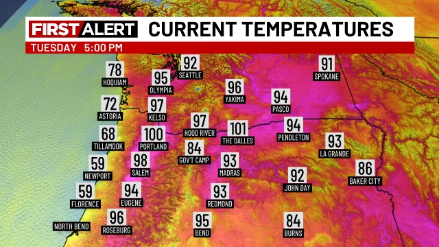
The “heat dome” is making its presence known today! Temperatures are well into the 90s pushing that 100 degree mark!
Tonight will be rough. I’m going with a low of 69° which is way too warm for a low in my book, and it will literally take all night just to get there. For reference, it’s still going to be a muggy 81 degrees at 11pm tonight. Brutal if you don’t have AC.
Wednesday will be similar, and the humidity and very warm start to the day will make tomorrow feel hot with highs likely topping out in the mid 90s. Showers and thunderstorms are possible at any point Wednesday through the early morning hours of Thursday.
Here are a few estimated radar images from two separate models showing the scattered thunderstorm potential during the day on Wednesday.
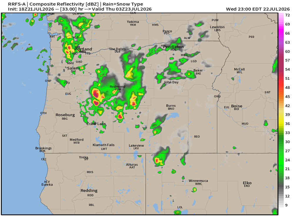
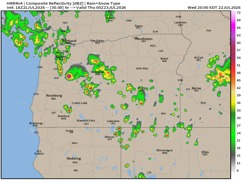
The important message to take away from these is how some of us will see thunderstorms and some of us won’t, but that everyone should plan on the possibility for storms arriving tomorrow and lasting through the early hours of Thursday morning.
Thursday and Friday
Most of Thursday will be dry, partly cloudy and warm. Lows will again start in the 60s, I’ll go with 65°. Highs in the mid 80s. Similar situation on Friday but with a cooler/more reasonable morning low. Temperatures Friday morning begin closer to 60 degrees before reaching the mid 80s.
Saturday – Tuesday
Much cooler weather settles in Saturday. In fact, we could see some a few light rain showers with temperatures only in the low 70s for highs. This map below shows precip totals from 11Am through 5pm Saturday. I’ve labeled Portland, Salem, and Eugene on here with some top notch editing haha. I’ve also drawn a line along the Coast and Cascade Ranges highlighting those areas as they will receive the bulk of the precip.
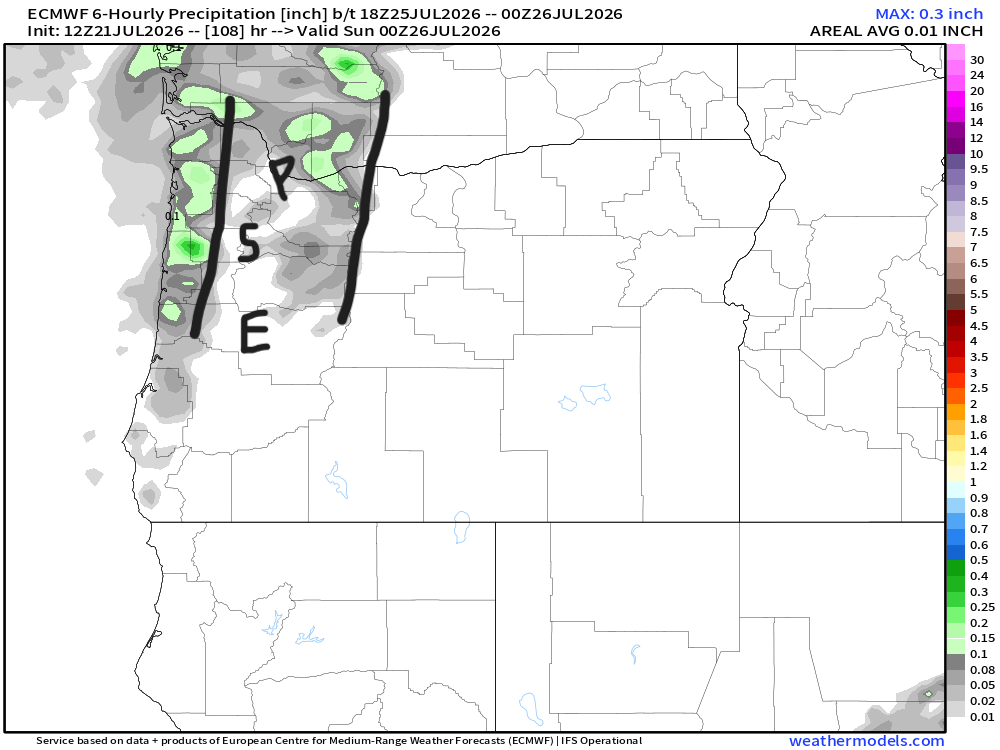
The way I interpret this map is the mountains and coastal areas will see at least a little bit of measurable rainfall, and the Willamette Valley could see a few sprinkles or brief light shower. Anything we do see would be less than in the aforementioned areas. How far north or south you are will also effect chances at seeing some light rain. Eugene for example will probably stay dry. This type of cooler and damp weather goes a long way in reducing fire danger west of the Cascades, even if it’s just a few hundredths of an inch. East of the mountains is a whole other story, and sadly, I don’t see a lot of help for those fires yet.
Sunday – Tuesday remain on the cooler side of average, but dry. Probably lots of morning clouds each day with some nice sunbreaks during the afternoon hours. Highs 78 – 82°. Lows will finally return back down to the mid 50s.
Next Wednesday through the first weekend of August
Pretty normal summer weather. Lows in the 50s each morning, and highs in the low to upper 80s depending on cloud cover.
As always, stay safe and have a fantastic week!
 Bryan Weather Alerts