We finally have something different other than sunshine and or morning clouds turning to sunshine lol. Our reliably dry summer pattern is going to be interrupted Wednesday night and Thursday by a chance for showers and even some thunderstorms.
Details
Beginning very late tonight and more likely Thursday morning, showers and thunderstorms will develop and move across the northwestern corner of the state.
Pinpointing who gets an actual thunderstorm with lightning and thunder is tough, but I’m confident most locations roughly from Albany and Corvallis northward and extending west all the way to Seaside, Astoria, and southwestern Washington will at least see some form of shower or brief wetting rain tonight through Thursday morning.
Thursday will also be much cooler, albeit a little muggy feeling with the added moisture. Highs will be limited to the mid to upper 70s with the added cloud cover.
Sunshine returns for Friday and we remain on the warmer side and even borderline hot through most of next week with highs approaching the low 90s Sunday through Tuesday.
It’s beautiful day out there and honestly, I see very few changes to our nice summertime weather for the next 10 days. Check out the webcam from this morning overlooking the Newport waterfront.
Details
The amount of ocean (marine) air coming eastward into the Willamette Valley will be the primary influencer or wildcard concerning temperatures day to day. Today for example will be pretty reasonable despite the abundant sunshine as cooler air from the Pacific Ocean sort of leaks inland.
Lows through Sunday morning will be in the low to mid 50s. Highs will range from 77 to 82°. I see we started out this morning at 52°. Saturday will probably be the “coolest” day with a high of just 77° as more marine air pushes inland that day.
Next Monday through Wednesday will likely be warmer, but still not “hot” with highs soaring into the 80s. I’ll go with 84° for Monday, 86° for Tuesday and back down to 82° on Wednesday. Lows during this time will only fall into the mid to upper 50s.
In recent days maybe you’ve heard about a “heat dome” or some other phrase to describe the heat to our east. This heat dome will be expanding and moving closer to us next week, but it’s clear to me that we will remain on the edge of it with enough marine influence still to prevent any sort of heatwave. Take a look at this map for next Tuesday showing the large high pressure (heat dome) way to our east. The warm colors correlate with hot weather, the white or lack of shading is fairly average, and the blues indicate cooler airmasses up above (about 18,000′ above sea level).
The bottom line is our reliable, dry, and warm Oregon summer weather is in full force. There is no rain in the forecast, no heatwaves (for now), and no chances for thunderstorms here in the Willamette Valley. Enjoy summertime living in this beautiful corner of the world we get to call home. 🙂
In short: we are done with the rain for the week. Dry for the next 7+ days. This is hands down the biggest change to the forecast. Maybe a sprinkle in the northwestern tip of the state Thursday night, but otherwise we are now moving back into a dry summertime pattern.
Temperatures will still be on the cooler side through Friday. Highs Tue – Thu will be in the upper 60s to near 70° with lots of clouds around and a few PM sunbreaks.
Friday: Highs in the upper 70s as clouds finally clear out.
The other big change is I’ve upped our temperatures for the weekend. Highs in the low 80s both Saturday (the 4th) and Sunday. Maybe a few AM clouds, but mostly sunny afternoons.
Today was a little bit of a surprise, but in a good way I suppose. There was very little rain during the daylight hours, and many more sunbreaks than I anticipated (I can admit when I’m wrong). The rain last night and early this morning however did not disappoint. Salem up to Portland generally had around 0.3″ of rain or more – a decent summer soaking.
Main headline
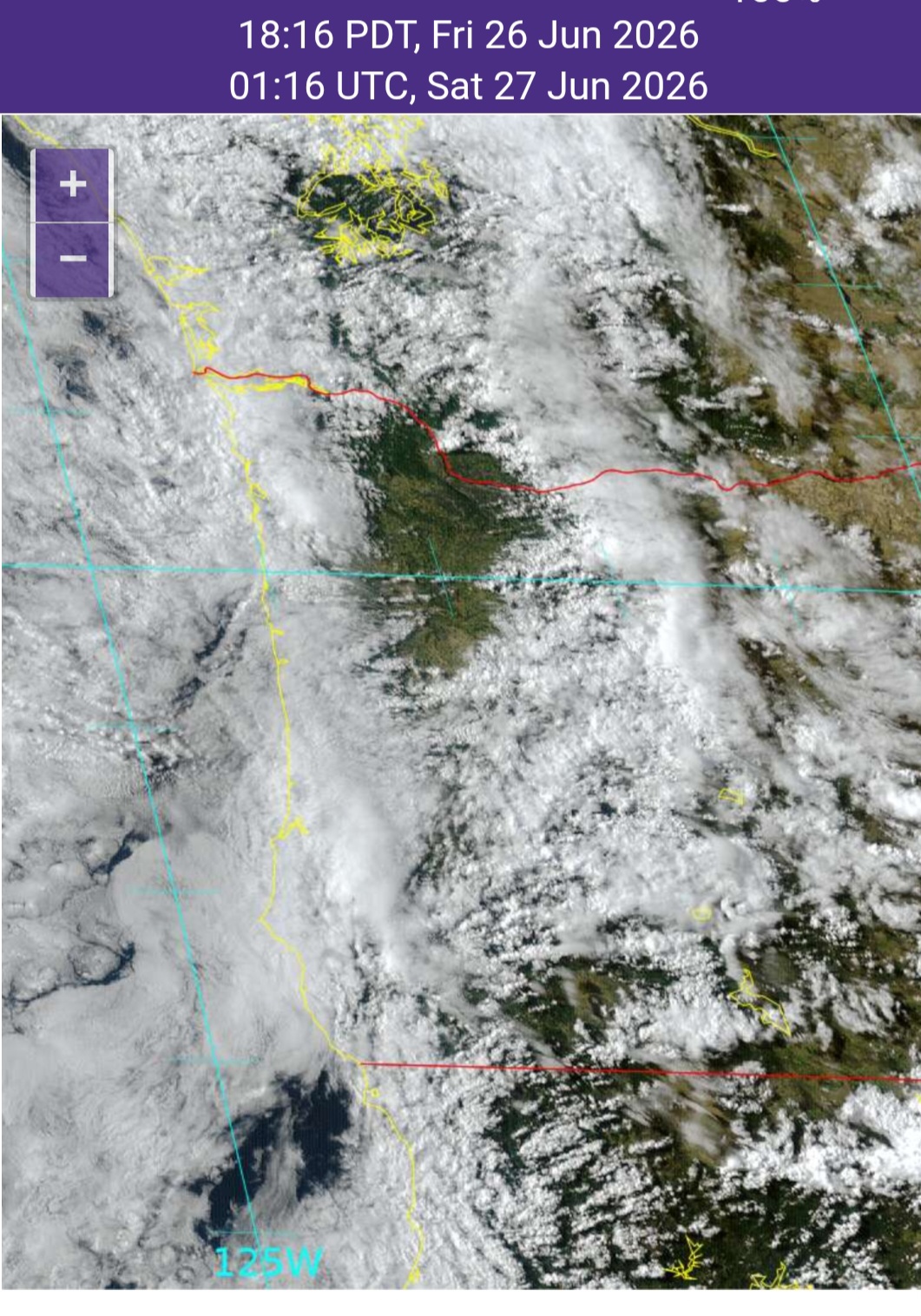
The drier day today was well within the realm of possibility when I was looking at the models and maps yesterday, but I didn’t think it would be this dry. Check out this satellite image from a little after 6pm this evening. Turns out this mostly sunny weather was limited to an area from Corvallis and Albany north through Portland and Vancouver. Everyone else west of the Cascades was cloudy most of the day.
We got lucky today, but don’t count on it for Saturday. Saturday will almost certainly be much wetter with showers, downpours, and some thundershowers even. Yes, brief lightning and thunderstorms are possible during the day tomorrow. On and off showers last at time through the late evening hours.
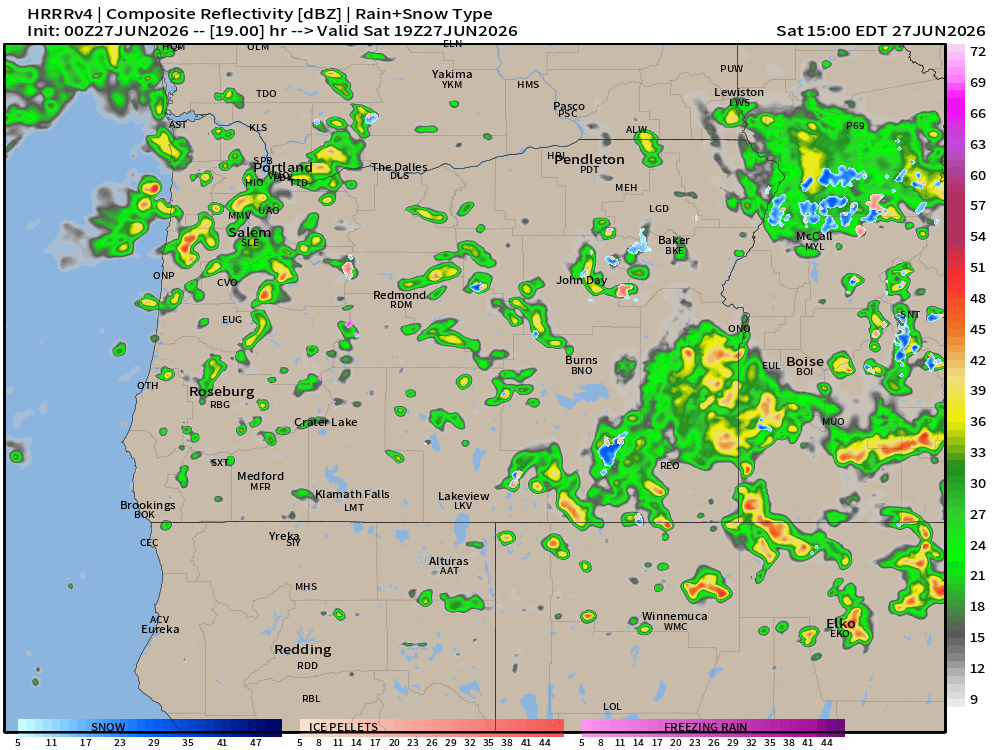
This image for noon on Saturday shows much stronger and more widespread showers than what this model depicted for today. Another reason (among several) as to why I believe Saturday will be wetter and stormier.
Sunday and next week
A few light showers Sunday and maybe even Monday with highs in the mid 60s.
Tue & Wed will be partly cloudy and dry. Highs in the low 70s.
Thursday and Friday: Showers return. Not an all day washout, but wet at times for most locations west of the Cascade crest with occasional showers. Highs back into the mid or upper 60s.
Independence Day (July 4th)
Still looking dry with highs in the low to mid 70s.
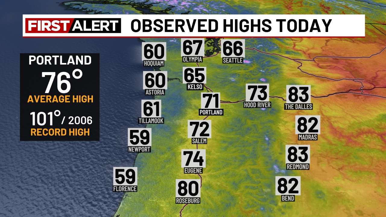
We’ve had a pretty warm/hot week with three days in a row topping 90, but today is much different! Our unofficial high temperatures for today look like this:
A much chillier day today as cloudy weather has set in. Even central Oregon was toned down a bit with highs only in the lower 80s. The cooler weather is here to stay for the next 8 or 9 days. Details below!
Details
Friday
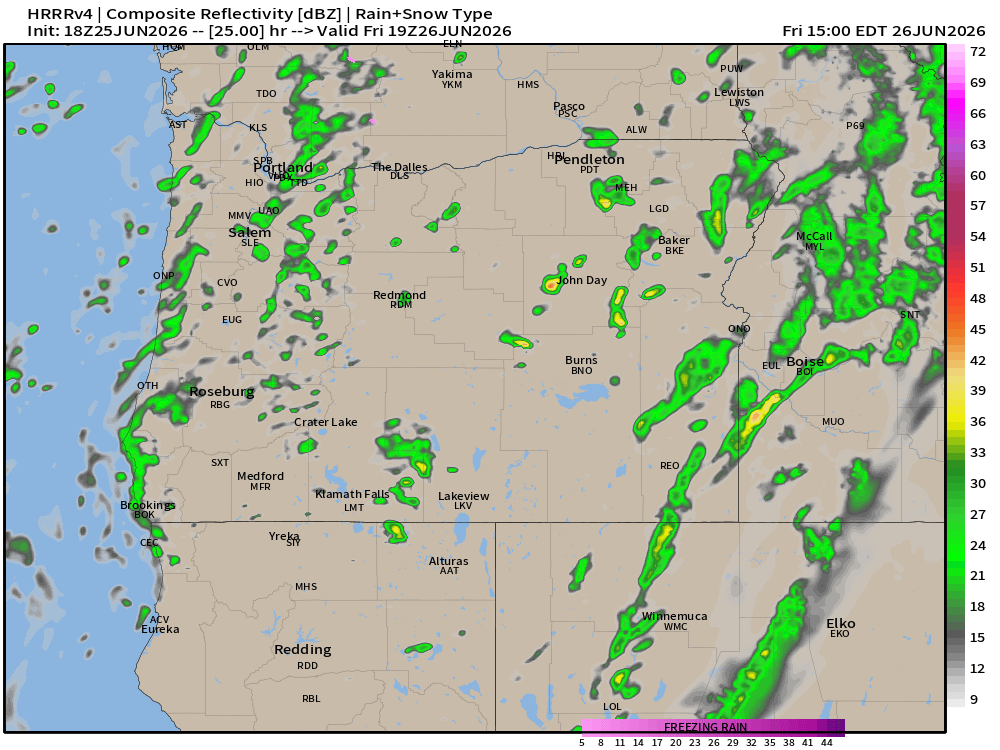
Mostly cloudy day with a few showers. Similar to today, but with a slightly higher chance of a shower. High of 65°. Estimated radar for noon Friday looks like this:
Saturday
Sunbreaks with showers. A few downpours, and even a brief thunderstorm are all likely at anytime Saturday. High of 66°. Keep in mind that while the sun may make an appearance at for a little while, it could change with showers possible right on through Saturday night.
Sunday
Mostly cloudy with slight chance for a shower, but the majority of this day will be dry. High of 67°.
Monday – Wednesday
Lots of clouds with afternoon sunbreaks. Mainly dry. Most areas will be dry, but with strong onshore flow at times, I cannot totally rule out a brief light shower. Highs in the low 70s.
Thursday and Friday
Showers return Thursday and could last through Friday. Highs back down to the mid and upper 60s.
Have an excellent rest of your week and enjoy the much cooler and wetter weather. Poor timing for weekend plans (I can attest to that), but it will be beneficial in many other ways.
Let’s get straight to the forecast first, and I’m happy to say that we are not done with the rain for summer yet. Details below!
Forecast details
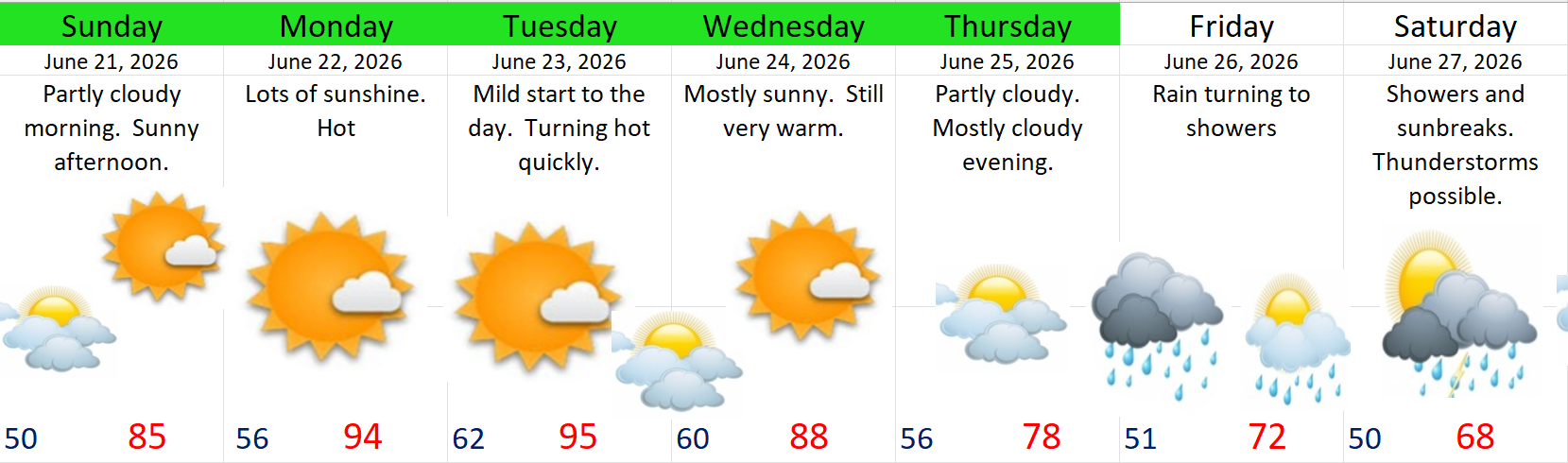
1.) Sunday (Father’s Day) looks great in my opinion. A nice cool morning with a few clouds likely. Nearly wall to wall sunshine for the afternoon though. High of 85°.
2.) Monday – Wednesday are going to feel rather hot with widespread highs in the 90s. Thursday will be much cooler.
3.) Thursday night into Friday morning is when I expect rain to arrive. This should be a nice steady rain hitting the entire Willamette Valley and most of western Oregon for that matter. Rain changes to scattered showers in the afternoon.
4.) Saturday looks like a shower and sunbreak type of day with thundershowers possible.
5.) Probably a little too soon to be talking about next Sunday, but it’s possible that the showers persist into next Sunday as well. More details later this week.
I also expect to have additional details on rainfall amounts, timing etc. in a future post this coming week. For now, plan on a wetter Friday and Saturday, and at a minimum, cooler weather next Sunday.
Drought and wildfires
I see a lot of wild posts online, and trying to sort through truth versus fiction or speculation can be tough, but I suppose that’s why I’m here haha. In this section, I’ll discuss our current drought situation, and then why I’m not panicking about our wildfire season yet.
Drought update
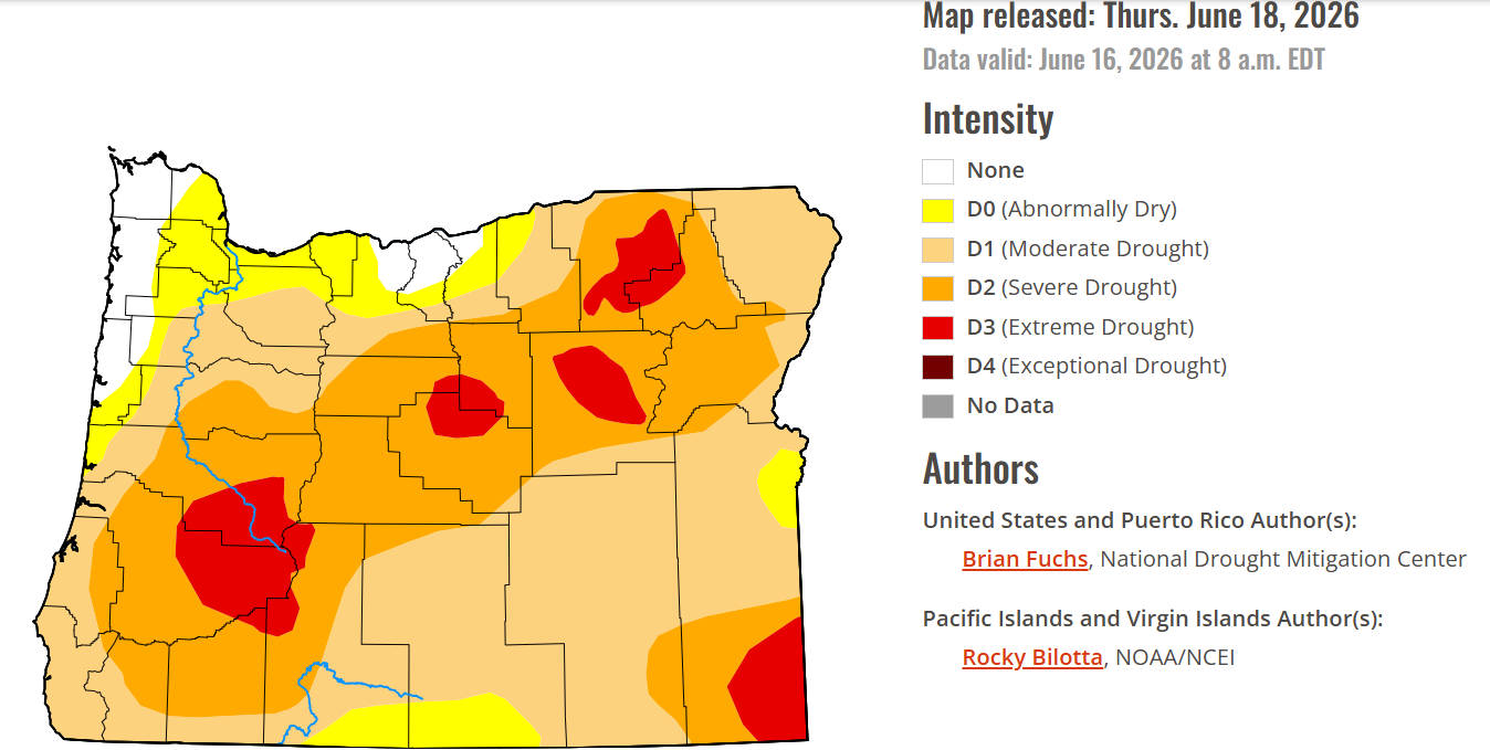
It’s true that most of Oregon has been much drier than normal for several months now. Salem is currently running at about 50% of our typical June rainfall for this point in the month. We picked up only 29% of our average monthly precip for May, 99% of average in April, and 71% in March. We have to go back to February to find a wetter than average month around here.
The drought monitor map reveals that it’s more of an issue the farther south and east one goes in Oregon. For instance. Just 50 some miles to our south, Eugene only had 13% of their typical May rainfall (versus 29% in Salem), and that’s been the trend for much of this spring. On the flipside, places to our northwest like Astoria and Clatsop County are actually doing alright.
We came into spring with almost no snow in our mountains below 4500 feet across the state – a near historic low. The lack of snow exposed vegetation and underbrush in our forests earlier than we would typically see and vegetation is drying out. The virtually nonexistent snowpack is the other major reason why large sections of central and eastern Oregon are facing such serious drought conditions.
Fortunately there’s some hope. A few days of wetting rain next weekend won’t end the drought, but it can’t hurt. More importantly, the rain next weekend could really put our fire season on hold west of the Cascades, and that brings me to my final point.
No need to panic about wildfires yet
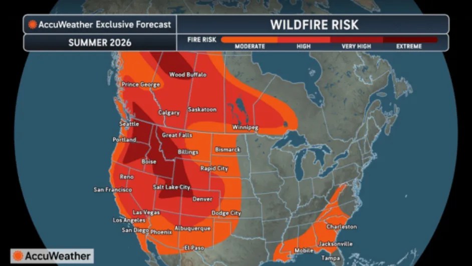
I want to remind you that fire season around here has much more to do with what occurs during June through September rather than the months prior, but in our world of clickbait, likes, subscribes, and follows, dramatic headlines often take center stage. Click on the images below to get a closer look.
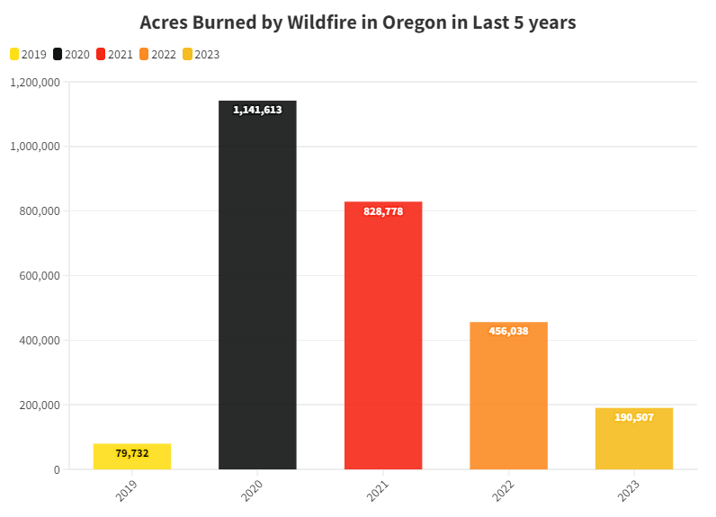
And honestly, these are just a small sample of the posts I’ve seen. I’m not forecasting how bad the fire season is, but I want to set a few things straight. If you were to ask random people off the street, I’m certain most of them would believe that every wildfire season over the past decade has been worse than normal, but that’s actually not true. I think a lot of it has to do with perception and headlines like you see above. When’s the last time you read a headline telling you that we had fewer acres burned than normal? Those headlines are out there, but they simply don’t make the rounds like scary predictions do.
For example, do you recall seeing this image circulated a few years ago (2023)? Probably not…. Such reality checks are hard to come by in our media these days. There’s rarely any follow up on what actually took place. Only dire warnings of the future. These numbers below were provided by the Oregon Department of Forestry and the Northwest Interagency Coordination Center.
If you think about it, every single summer here is generally warm and very dry regardless of how much rain fell during the previous winter. Yes, the lack of snow in the mountains this year made things worse earlier than normal, but how bad fire season gets really depends on the conditions we see in summer. Well timed summer rains can go a long ways in preventing large fires. Consequently, poorly timed dry thunderstorms with lightning strikes and gusty dry winds can make the season terrible (think 2020).
Lastly, and very sadly, people have been an increasingly higher cause of fires than in the past which can really alter what could have been a quiet fire season. If you want to read more, here is an article from the end of last summer: 2025 fire season – less acreage, but more human causes
Hopefully we will never tire from seeking the truth. Okay, have a fantastic Father’s Day celebrating the fathers or fatherlike figures in our lives, and stay safe out there! 🙂
After a cooler than average June, we are turning up the heat quite a bit! No sign of rain returning either which means summer weather is here to stay for the time being. Details below.
Details
Today – Tuesday
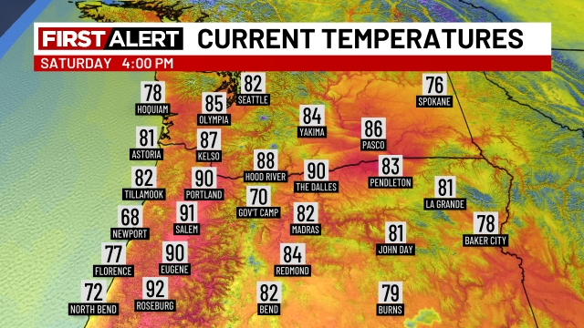
We just cracked 90° today. At 4pm this is what temperatures across the northwest looked like.
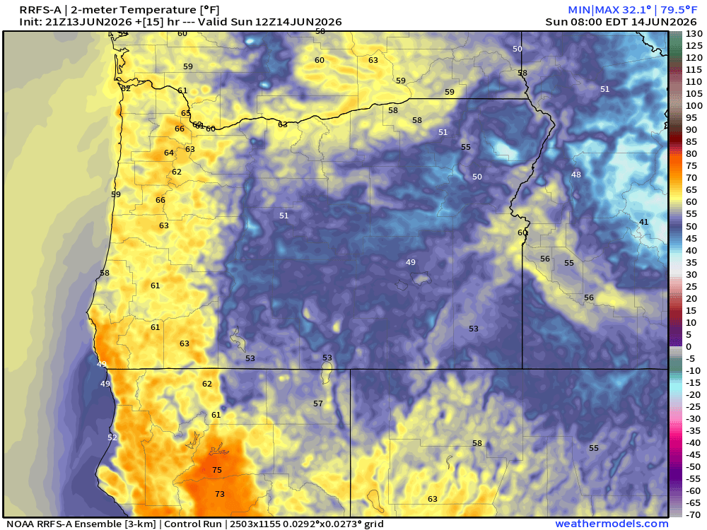
Hot, but we are already heading back down (very slowly). As of 5:30pm we are at 90. Winds have also been gusty (just shy of 30mph), and I expect similar conditions Sunday afternoon/evening too. Obviously this is not our typical cool summer breeze, but a hot offshore wind. These conditions are going to prevent temperatures from cooling off a lot tonight. Temperatures at 5am Sunday morning are expected to bottom out in the low 60s for much of the valley. Check it out:
The heat continues Sunday and Monday featuring highs in the upper 90s. Tuesday will be back down to near 90°. Our most uncomfortable low temperatures occur Monday morning with lows only in the mid 60s. Not very convenient for cooling the house down at night.
Wednesday – next Sunday
Excellent regular summertime weather with highs ranging from 80 to 85° depending on morning cloud cover. A very stable, warm, and dry period. No thunderstorms, no sprinkles, no rain. Warm/briefly hot afternoons, and decently cool nights again with lows back down well into the low to mid 50s. Very pleasant summer weather if you ask me! 🙂