Quick highlights
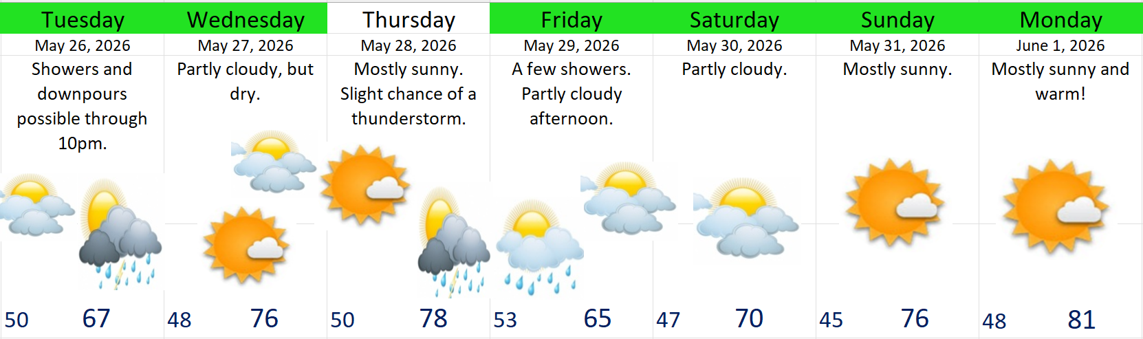
- Mostly dry weather over the next 7 days.
- A few areas could see thunderstorms. Storms have the potential to be on the strong side (watching Thursday in particular).
- A few showers Friday before a drying trend sets in.
Forecast
Details
1.) For the remainder of today expect a continuing chance for a rain shower or maybe even a thunderstorm through about 10pm. Highest chance continues to be near the Coast Range.
2.) Dry on Wednesday and mostly sunny.
3.) Thursday: Mostly sunny, but there’s a chance for evening thunderstorms. Storms will form east of the Cascades, and the steering flow aloft will be from the east/southeast that day. Furthermore, these storms will have a lot of support from the atmosphere making it easier for them to move right into the Willamette Valley Thursday evening. I’ll be watching closely. Just keep in mind that Thursday evening could turn into something impactful.
4.) Friday will feature some morning showers leading to a partly cloudy, but dry afternoon and evening.
5.) Saturday: Partly cloudy and dry.
6.) Sunday: Start of a warming trend. Highs near 80. Monday and Tuesday of next week will be on the warmer/hot side with sunny skies and highs climbing to the upper 80s by Tuesday.
Cascades and Central Oregon
Strong to possibly severe thunderstorms are possible both Wednesday and Thursday. If you are camping, hiking, traveling, or just going to be anywhere from Crater Lake up to Hood, and from Sisters, Bend, Redmond over to John Day and Hell’s Canyon or anywhere in between then pay attention to the forecast and what you see with your own eyes both these days. Between now and Thursday night, someone in Oregon is going to get slammed by strong storms. If I get around to it, I’ll put out another update Wednesday evening.
Take care and have a wonderful rest of your day!
 Bryan Weather Alerts