Boring winter weather

I’m sure a number of you enjoy this dry weather, but those of you who know me well know I love a good storm whether it be lots of rain, wind, snow, or ice, and sadly we have not had very many good storms at all this year. It’s been an especially boring winter overall with warmer than average temps and drier than normal rainfall, but life goes on.

Highlights

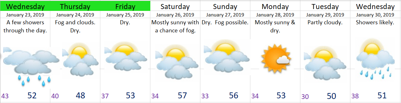
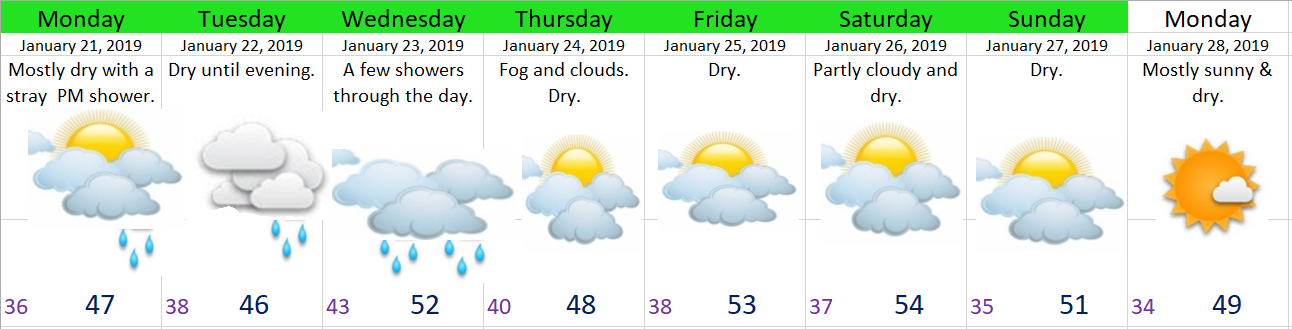
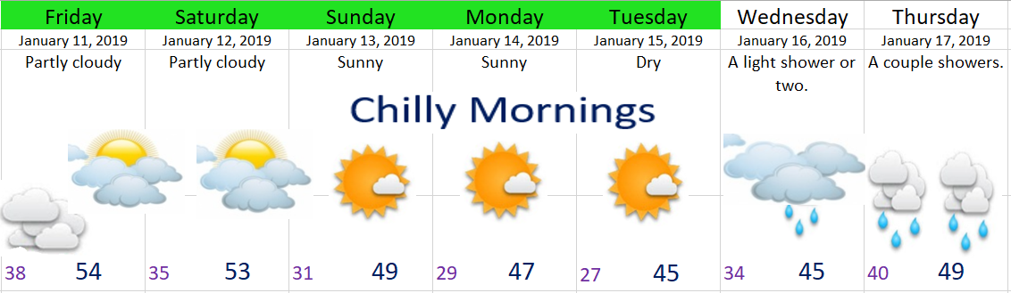
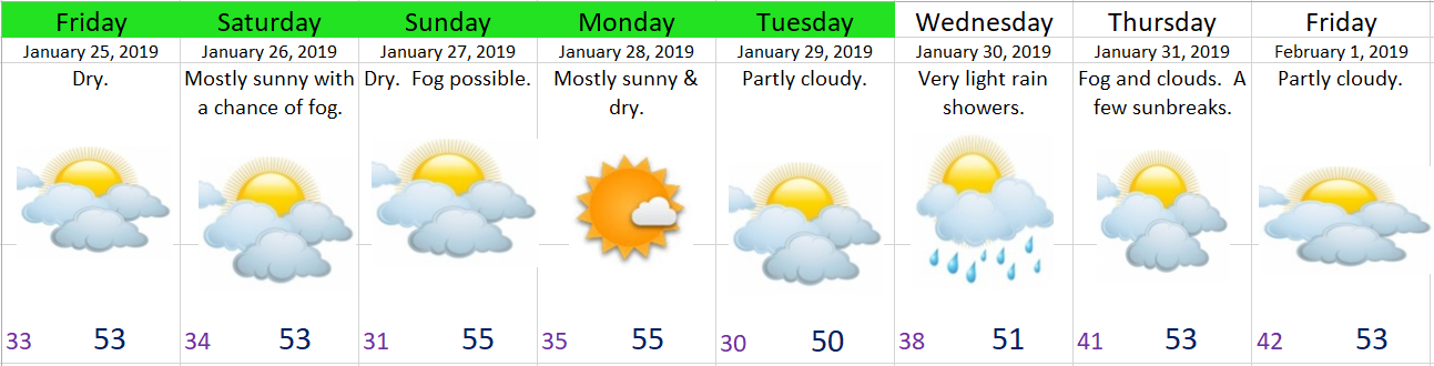
It looks to stay dry and mild for the foreseeable future with the minor exception of Wednesday when some very light rain showers will come through.

Following up on our “warm” weather potential this weekend I’ve decided to lower the high temps just a smudge. It will still be above average, but only mid 50s at best. Patchy fog is possible just about every single day this week which could keep temps cooler than what is currently forecast.


Jan 22nd

This is what we call a miss.  I said “dry until evening” in my previous forecast, but it appears as though the rain came several hours early today.  It’s also been a bit breezier than I expected, so sorry about that.  Tomorrow will be drippy/wet as well before we dry out Thursday and stay dry for at least several days.

jan 22

Additional thoughts

This weekend is a huge wildcard.  We will have a very warm air mass in place, but it won’t do us any good if we get socked in with fog & low clouds.  I’m watching closely, but as of right now I’m hedging my bets on sunny and mild with highs in the mid to upper 50s.  It will no doubt be dry during this time, so you can at least plan on that part of the forecast to come true 😉

After tomorrow’s showers we stay dry until next Wednesday!

Plain old January weather

After a few days without any updates I’m back in the saddle today.  This week’s forecast is looking real bland/plain with nothing exciting in the near future.

jan 21

Details

Today:  A slight chance of a shower later on this afternoon; otherwise, mostly dry.

Tuesday:  Dry start with light rain moving in from the north during the afternoon.  Locations south of Corvallis & Albany should stay dry.

Wednesday:  A few light showers for everyone.

Thursday:  Fog likely, turning partly cloudy as the day goes on.

Friday – Monday:  Partly cloudy & dry. 

Cool & wet

jan 15

Details

Wednesday is going to be a chilly day with showers at times and temps only in the upper 30s to low 40s.  Thursday will be wet with periods of rain.  Same goes for Friday.

Now if you recall in my last update I mentioned there was a chance Saturday could end up mostly dry.  After viewing the latest forecast maps it appears that chance is just about gone.  I guess that’s how it goes sometimes.  Anyway, it’s now looking quite wet Saturday and much of Sunday with a shower or two leftover on Monday.  Tuesday & Wednesday should be dry.


The Gorge

The east winds have been raging at the western end of the gorge and in the Portland metro area.  Those east winds continue through much of Thursday.  Light snow and some freezing rain is likely in the gorge along I-84 Wednesday evening and Thursday before “warming up” above freezing late in the day Thursday and more so by Friday morning.


The Cascades

14 to 20 inches of new snow is on the way above 4000’ Wednesday night through Monday.  Up to 6 inches is possible as low as 2000’ by Monday morning.  This means snowy travel conditions for several days.

And there you have it.  Nothing real exciting for now, but as always stay tuned for the latest changes and updates!!!

Chilly Monday morning

It’s a chilly 28° here in Salem this morning, so make sure to bundle up before heading out!

Looking ahead I see two more totally dry days (counting today) before turning wetter for the remainder of the week.

jan 14

Saturday could end up being a fairly nice day with only a chance for a shower very early on and then again late in the evening leaving the majority of the day nice and dry.  Will have a better idea in my next update.

Have a great Monday!!!

Mild & Dry

Did you notice how mild it was yesterday?  Salem tied the record high for January 10th at 60°F.  Check out some of the other very mild high temps across the area.

highs 1.10

The relatively warm weather won’t continue with temperatures gradually cooling over the next 5 days.  By Tuesday daytime highs should be down in the mid-40s and lows into the 20s.  Regardless of how mild or cold it is, the one thing it will be is totally dry through at least Tuesday. 

This type of pattern also gives strong gusty winds through the Gorge.  Winds will easily reach 35 – 40mph out near Troutdale with occasional gusts above 50.


The next 7 days

jan 11

There’s a small chance for a couple of wimpy showers Wednesday.  Thursday into next weekend are looking fairly wet.

Up in the mountains it will be easy going for several days with no snow until Thursday.


*Minor correction:  Salem’s peak wind gust from the storm last week ended up being 54mph, not 51mph as I stated.  Small difference, but as always I want to make sure I’m delivering accurate information for my wonderful viewers.

Storm recap and the week ahead

Brief recap of Saturday night’s storm

Was a quick storm with the strongest winds arriving right on target at around 8:30pm and dying off sometime around 11:30pm.  The Salem airport recorded wind gust of 54mph, our strongest gust this winter.  Many locations in the mid valley saw 48 to 54mph gusts.

Of course I love it when my forecasts turn out well, and if you have been following me over the last year you should have no trouble thinking back to a time or two (or more) when I missed a forecast.  Today I’m happy to say this weekend was not one of those times 😉 🙂


Okay, enough bragging, and onto the forecast for this coming week.  Currently we have very cold showers streaming onshore which will continue much of the night.  The snow level is quite low at roughly 1500 feet (for sticking snow), and will lower slightly tonight down to 1000’ or so.  Check out how Santiam pass looked late this afternoon.


Very snowy up there and that will continue to be the case through Monday night.  All of this is good news for our snowpack.  I see Hoodoo is now reporting over 50” of snow for their base!

Back down here in the valley, I suspect a few roads could be icy early Monday morning IF we get some extra clearing tonight, so pay close attention to conditions before you stepping out to go tomorrow. 

This coming week looks wet.  No big washouts, just drippy regular Oregon rain.

Best chance for dry weather is Thursday afternoon through Friday night.

Next weekend is looking wet..