Here we go again with more chances for snow only this time it’s March. I’ll get to all the fine details soon, but first the extended forecast.
In a nutshell I see several more opportunities for wintry weather before gradually warming up Saturday through Monday.
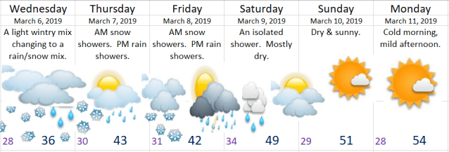
All the details
Tonight we slowly cool off back close to freezing. Just like last week’s little snowstorm I’ll keep a close eye on the temperatures as they will be an important indicator as to what falls from the sky later on. Regardless of temps, precip should arrive around midnight (give or take an hour or two). Precip will be very light and spotty at first as we have very dry air for it to overcome. Depending on how thick the cold air above us is we could see freezing rain, sleet or snow. I’m leaning towards a mix of all three, but more ice than snow as we will be right in the “battle zone” of the different air masses.
Precipitation will be very light: This looks like a drier version of last week’s storm that dropped 1 – 2 inches of snow. I’m going for a dusting of snow with areas of ice. Could be a messy early morning commute.
It’s March now which means even on a cloudy day the angle of the sun and it’s increased energy is enough to melt snow and ice off of roads from roughly 9 or 10am to 5pm), so travel during most of the day should be just fine even if snow is still flying through the air.
Cold air will be rushing in behind this storm giving us our second shot at snow Wednesday night. This is manly for the east side of the Willamette Valley. Basically the further east you live the better chance you have at seeing an inch or 2 of snow Wednesday evening/night.
Early Thursday morning a batch of heavier showers looks to roll in sometime between 4am and 10am. Temps are forecast to be right around 31 – 34° which means we could pick up a quick inch or two of very wet/slushy snow to start our day off. More rain and snow showers will fall the rest of the day. Just like Wednesday, there should be no travel concerns past about 10am. The rest of the day should be just fine.
Same story for Friday. Morning snow will give way to a few afternoon rain showers.
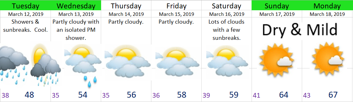
Beyond Saturday it looks like we have a brief warm up and dry break coming for Sunday and Monday. If this holds true it will feel very nice after this cold week.
THE CASCADES AND BEYOND
Tonight through Saturday morning I expect snow at times in the Coast Range, and plenty of snow in the Cascades even during the daytime up there above 2000′. The Gorge will also be messy, so if you plan on traveling through any of these regions be prepared for wintry weather with snow and ice.