Happy Thursday everyone! From what I’m seeing it appears as though the train is still on the tracks for now. Hahaha!!! Check out regional temps as of 11AM:
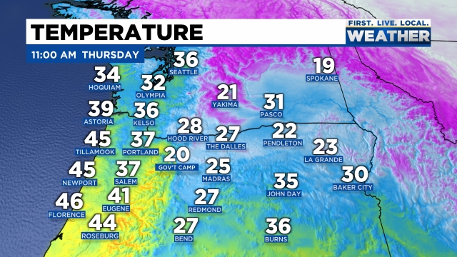
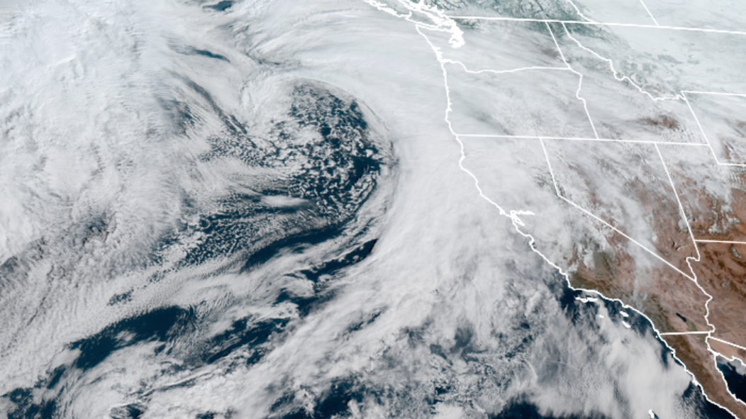
As you can see there’s a lot of very cold air east of the Cascades which is blasting through the gorge straight into the northern Willamette Valley. Next take a look at the satellite view of the storm rolling in. It’s a beast of a storm!!
The greater Portland metro area: All of Clackamas, Washington, and Multnomah counties, as well as parts of Yamhill County are looking at what will probably be a major top tier snowstorm. Locations further south like Wilsonville and Newberg may only pick up 2 to 6 inches of snow, while cities both close to Portland and cities north and east of Portland could easily see – and I’m not kidding – well over a foot of snow between now and Saturday afternoon! Plan on Portland being an absolute mess through Sunday, perhaps even into Monday with Portland metro roads freezing up and turning snowy before the PM commute this afternoon.
THE SALEM AREA
TIMING: Salem falls below freezing tonight. The cold air is currently spreading down into our region at a more “aggressive” rate than what some models were initially showing. Due to this fact, I’m feeling confident that Salem drops below freezing between 7 and 10PM tonight. This is a little bit sooner than what I said in my last update.
What to expect: For today we will only see cold rain. I’m still thinking we end up with a brutal mix of freezing rain, some sleet, and a little bit of snow at times beginning late tonight and lasting on and off through Saturday morning. My concern is that freezing rain will be our dominate precip type for the duration of this event. This could end up being an extremely hazardous and dangerous ice storm for the immediate Salem area. I’m thinking lots of trees, tree branches, and limbs coming down.
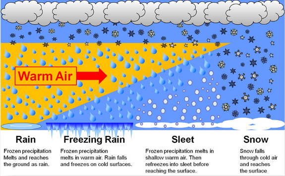
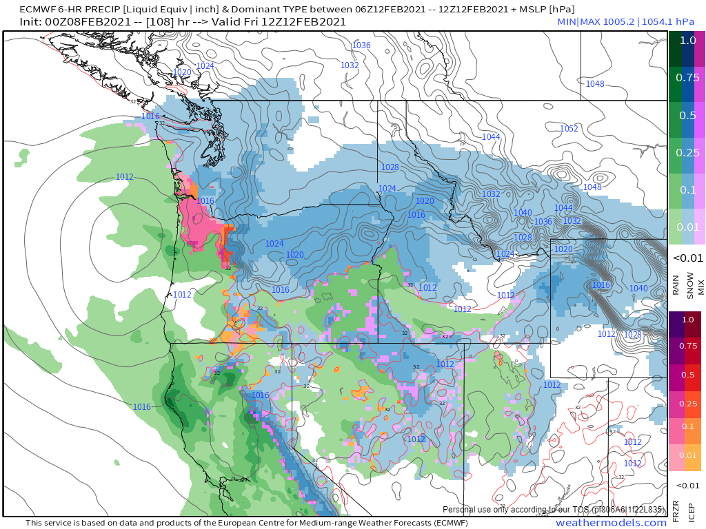
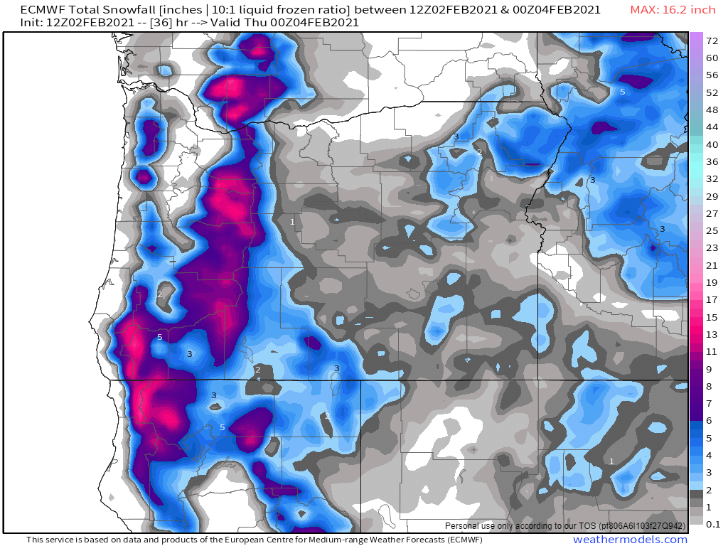
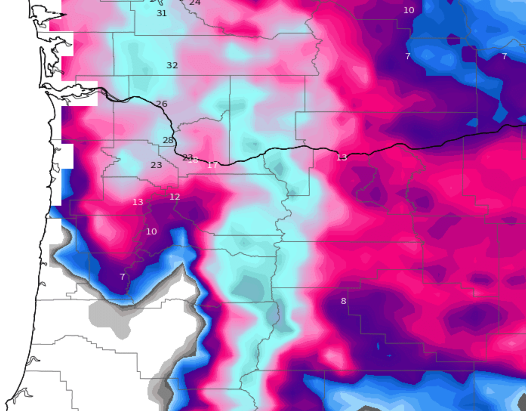
Because we are so close to the deeper cold air, it is very likely that we switch back and forth between freezing rain, sleet, and snow over the next two days. Being right on the edge of the cold air will cause us to do a lot of switching between precip types. I want to illustrate why this forecast is so tricky. This first pic shows estimated total snowfall in inches ending Monday morning.
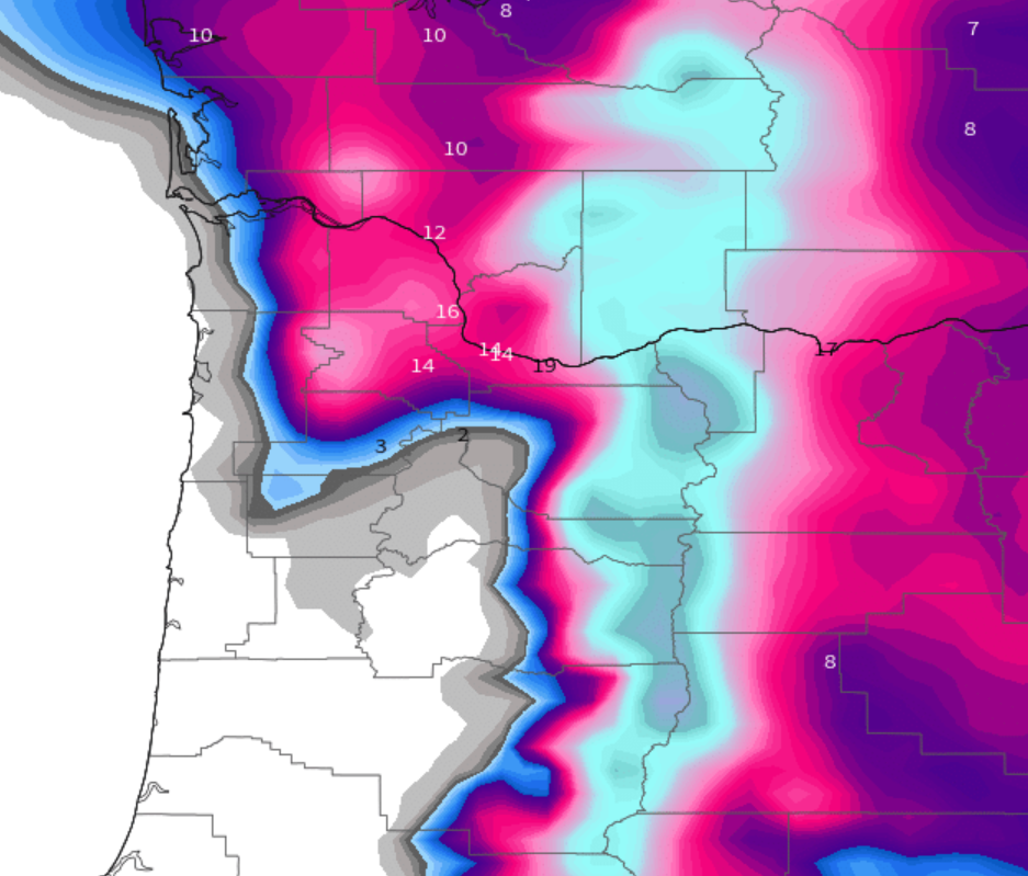
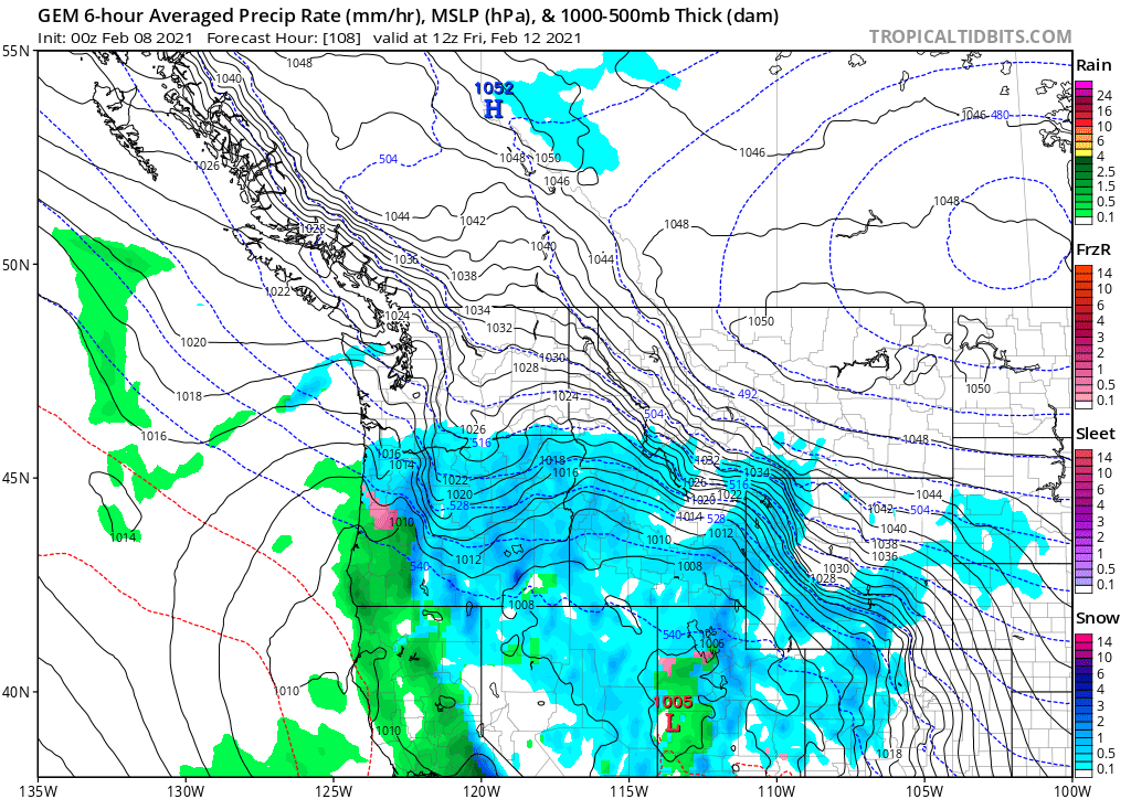
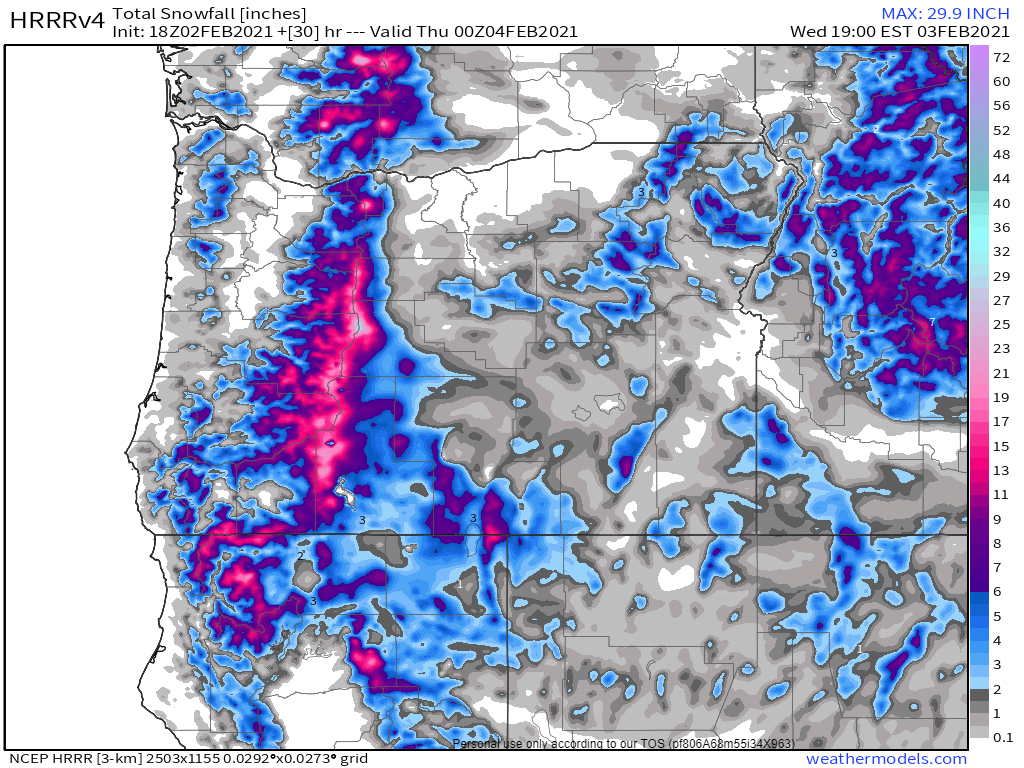
If this model is correct, Portland will end up with 12 to 18 inches of snow while Salem sees maybe an inch or two at most (I’m accounting for the cold air being slightly further south than what this model predicted.) In this scenario Salem would see a better part of an inch of freezing rain!! This could easily be one of the more serious ice storms we have seen in at least a decade. HOWEVER…… 🙂 Check out this next map from the other major weather model. It shows what could happen if the cold air is even more aggressive in moving in, with Salem receiving over 10 inches of snow and only a little bit of freezing rain.
If you take a blend of these two models, which is sorta what I’m doing, you end up with a lot of freezing rain and a little bit of snow. As much as I would like a ton of snow, I’m leaning more towards the freezing rain outcome being correct with just some snow here in Salem. I do recognize, however, that if things trend a little bit colder we could still see a big snowstorm here as well!
Either way Salem should stay close to or below freezing tonight through Saturday morning/early afternoon. This time of year it’s possible roads could be okay to drive on during the peak daytime hours on Friday if precip lets up and if we get a break in the clouds, but don’t bank on that. Drive as if they are still icy, stay safe, and plan on roads being a mess beginning late tonight through Saturday morning. At some point Saturday afternoon we should warm up above freezing and begin the melting process here in Salem. Portland will take longer and may not thaw out until Sunday afternoon.
I will continue to check real time observations to see if we are running warmer or colder than expected, and there are always little surprises that happen which simply can’t be forecasted and it will be interesting to se what actually transpires. Anyway, no promises on when the next update will be, but keep an eye out and plan for an icy few days with more snow the further north you go.