If you’re like me, well okay, if you at least share my love for weather, lol, then you probably enjoyed both the windy/stormy weather last night and the nice sunbreaks today. We have another round of wind & rain coming up Tuesday morning. Winds will again gust 25 to 35mph along with periods of rain.
Tue: Rainy at times and windy. Gusts 25 – 35mph.
Wed: Mostly dry with a couple of leftover showers. More showers up in the mountains and the further north you go.
Thu – Sat: Partly cloudy, mild afternoons, and dry. Lows in the 40s and highs 64 – 70°.
Sunday: The largest change to the forecast is the chance for a few showers on Sunday. Most of the weekend will still be dry, but if you’re outdoors on Sunday keep in mind you may have to dodge a couple of brief downpours before it dries back out.
Happy Friday!! I hope you all are enjoying October. We have a very wet Saturday on tap with close to an inch of rain expected tonight through the day tomorrow. Breezy too with gusts early Saturday morning of 20 – 30mph. Rain should move in tonight around 10pm.
1.) Sun & Mon: Showers at times with more breezy/gusty winds up to 30mph Sunday night.
2.) Tuesday starts off dry with rain moving in late afternoon.
3.) Wednesday will be the opposite with a few showers early morning; otherwise a mostly dry day.
4.) Thursday through next weekend (the 17th & 18th) looks dry for any outdoor activities you may have planned.
Below is the estimated total precipitation through Wednesday. These maps aren’t perfect; however, they do a decent job of showing roughly how much precip can be expected and where it will fall.
Basically we can expect about 2″ over the next several days here in Salem with more in the mountains and along the coast. A good fall soaking bringing rain even east of the Cascades which will help end the fire season over there! As mentioned, dry weather returns Wednesday afternoon and should last through next weekend.
Not quite a full week of sun, but now through Fri will be dry & mild with lots of afternoon sun. Clicking on the satellite link below you can see how the Willamette Valley is just now starting to break out of these stubborn low clouds. The sun is on its way, but definitely taking its sweet time today. We should turn sunnier much quicker both tomorrow and on Wednesday leading to highs in the upper 70s.
1.) Today – Thu: Areas of morning clouds and fog. Lots of PM sun. Thu will see a few more clouds, but still dry.
2.) Fri: Mostly dry with showers not moving in until 5 – 8pm.
3.) Saturday will be stormy. Steady rain with gusty winds out of the south at 20 – 30mph will rule the day before transitioning into showers during the late afternoon. Expect rain to be heavy at times. We even have a slight chance for a few rumbles of thunder.
4.) Showers & sun breaks on Sunday. Steady rain moves in Sunday night.
5.) Next Mon: Showers.
There you have it. Enjoy the nice dry weather this week and stay healthy!
Salem had a toasty high of 85° today!! The next several days are going to be much warmer than normal with highs in the mid 80s as we end September and begin October. I imagine everyone will be doing their best to enjoy the nice weather because we all know our wet season is just around the corner…
Since fall is here, even if it doesn’t totally feel like it, I figured it could be both fun and a good time to share a few thoughts on this upcoming winter. I’ve never done something quite like this before and to be honest some years, like last year, are more of a crapshoot; however, this year we are expecting a moderate La Nina which gives us a few extra hints as to what type of weather we are likely to see this winter.
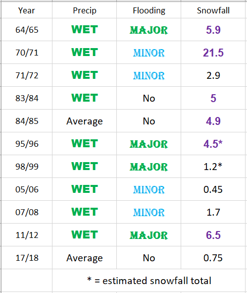
For this discussion I analyzed 11 La Nina winters which had similar strength to the one being predicted this year. I’ll also be referring to the months of November through March which I consider to be our primary storm/winter season. There are some years where the storm season really gets going during mid October, and this could be one of those years, but the statistics I looked at and the focus of this discussion are centered on the months of Nov – Mar. This first chart shows those 11 La Nina winters and how they fared in terms of precipitation for Salem, whether or not there was a valley flooding event, and Salem’s total snowfall in inches during each of those winters.
* = Estimated snowfall total as official records are not available those years.
1.) Perhaps the number one thing that stands out is how wet La Nina winters typically are in the valley. 9 of the 11 La Ninas surveyed gave Salem above normal precip. That lends pretty solid confidence we will end up wetter than normal. As is the case every winter, Salem should still see a number of dry days mixed in. The key thing to remember is that overall statistics favor a wetter and rainier than normal winter for the Willamette Valley.
2.) Not shown on the chart, but odds also favor an above normal or at “worse” an average mountain snowpack this year which is great news for skiers/snowboarders and our water supply. One caveat is there have been a few La Nina winters which got off to a slow start in the snow department meaning Nov and Dec weren’t necessarily real good in terms of mountain snow; however, the vast majority of those winters still saw an excellent second half to the ski season as snow ramped up nicely in Jan and Feb of those years.
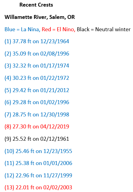
3.) This next one is not good news. Keep in mind I’m strictly talking odds here by looking at what happened in past La Ninas, but for this one the odds are not in our favor. Of the 11 years surveyed, 8 saw a notable (either minor or major) valley flooding event. The percentage of La Nina years with significant flooding events is high when compared to non La Nina winters. Below is a list of historic flood events on the Willamette River in Salem. This list only contains floods occurring since flood control dams were built in the 50s. It’s no coincidence that 10 of Salem’s 13 worse floods occurred in La Nina winters, and while it’s far from certain, one would be wise to keep this in the back of their mind, especially if you live in a flood or mudslide prone region as the odds of seeing some sort of flooding event this year are higher than normal….
4.) Perhaps the most anticipated question is whether or not it’s going to snow here in the valley. Well, 11 of the 11 La Nina winters I reviewed in detail produced at least some snow here in Salem. Woo hoo! Breaking it down further, 6 of those years produced enough snow for sledding or building a snowman in (highlighted in purple on the chart). The other 5 only saw minor accumulations of a slushy inch or two. Take it for what you want, but odds are high we at least get an inch or so of snow, and odds are higher than normal we see a respectable/decent snowstorm at some point this winter. Far from a slam dunk as I like to say, and we are talking statistics, but it does provide some extra hope for us snow lovers. Definitely better odds than last winter! 🙂
So yes, may the odds be ever in our favor, and with how 2020 has gone I really do mean that. A quick recap for you:
1.) Odds favor a wetter/stormier than normal winter overall.
2.) Odds favor a good mountain snowpack and good year for ski resorts.
3.) Increased odds for a significant valley flooding event.
4.) Higher than normal odds for some valley snow.
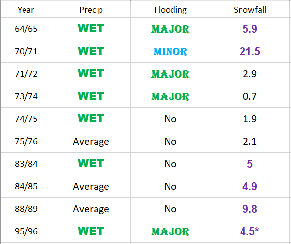
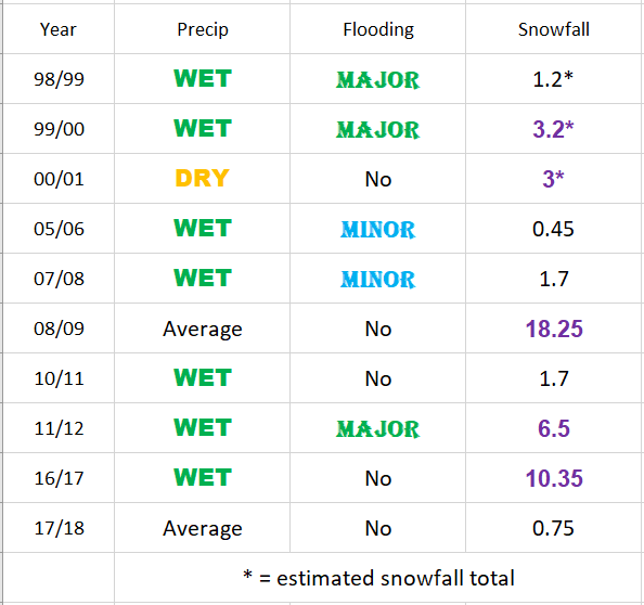
For reference, here are all La Nina winters (regardless of their strength) since 1960. Again, the pattern is the same. Almost all of them ended up wetter than normal, many of the years had flooding here in the valley, the majority of these years had a good mountain snowpack, and all of them produced at least some measurable snow (albeit some years it was no more than an inch or two) down to the valley floor.
The odds definitely favor a more active winter, but only time will tell, so be ready for anything, and then I guess just sit back and see what happens…
Any questions?? Lol, it’s a very straightforward forecast this week. Mostly sunny every single day now through at least next weekend, maybe even longer. Areas of morning clouds will show up some days, especially during the second half of the week, but even those days will end up with sunny and warm afternoons.
Highs generally 80 – 85° all week long – a good 10 degrees above normal.
Lows around 50 – 54° each night will make for chilly evenings & mornings, but as chilly as that may feel to us, these temps will also be several degrees above normal. For reference, Salem’s average low temps this coming week are around 45 – 46°.
After the soaking rains we saw this past week, the fires will be slow to spread despite the dry weather. A little bit of smoke may drift back towards the valley, but if it does it will be minor, and nothing even remotely close to what we saw earlier this month.
We have a good old fashioned fall storm out there today. Breezy south winds have been going all day and the rain won’t be too far behind. I imagine the rain will get going here in Salem between 2 and 4pm. Expect the better part of an inch of rain to fall with this storm along with more gusty winds.
Thursday’s weather will feature showers and thundershowers. Thundershowers are most likely north of Salem and along the coast; although anyone could see a few brief downpours or small hail with the “regular” showers tomorrow.
Showers stick around for both Friday & Saturday with Friday being the wetter of the two days.
I’m still feeling confident Sunday will kick off a nice stretch of late season sunny and warm weather with highs next week reaching well into the 70s & 80s. The best part about it is we will actually be able to enjoy the nice warm weather this go around since most of the wildfires around here will be on life support thanks to both the coming rainfall and the continued hard work of the firefighters who are still out there working on these fires.
The Oregon Coast
The largest waves of the season will arrive today with waves heights of 20 – 25 feet expected this afternoon through Friday. Not exactly the biggest waves ever, but definitely the largest so far this season. Will make for some fun storm watching weather should you find yourself at the Oregon coast.
The nice weather next week won’t be limited to the valley. Warm, sunny weather is expected along the coast with Tue – Thu being the nicest days and highs in the mid to upper 70s. Winds may still be breezy at times next week with the warm weather, but let’s be honest, when are they not breezy out there? 😉
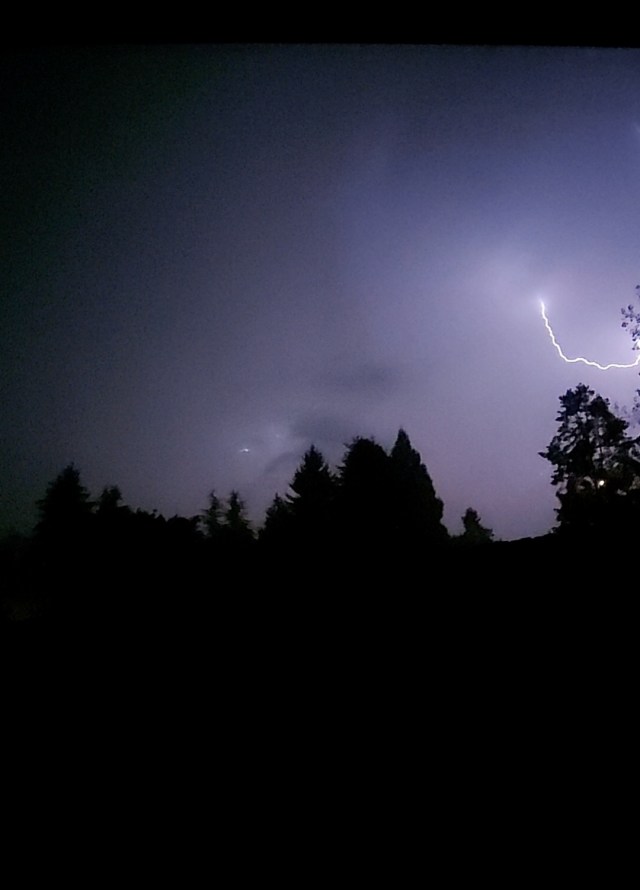
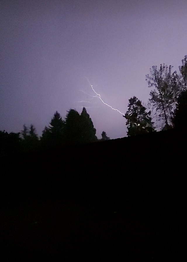
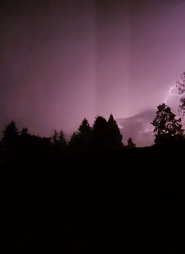
It’s been a few day now, but those were some wild storms the other night, wouldn’t you agree? Many locations around Salem picked up over an inch of rain that Thursday night. I picked up 1.18″ at our south Salem home. Much of that falling within 30 min!! The other exciting part of those storms was the amount of lightning produced. Here are a few images I caught on video.
Looking forward we have a couple of nice dry days before rains move back into the region on Wed. Here’s your forecast for the week ahead:
Highlights
1.) Overall fairly high confidence with the forecast this week. Wed may initially start off dry, but it won’t last long as a steady rain and breezy winds move in. In fact Wednesday is looking like quite the soaking with anywhere from half an inch to an inch of rain expected. More good news for the fires continuing to burn up in the Cascades.
2.) Thu & Fri: Showers and sunbreaks. Chance for a thundershower Thursday, but this will be a more typical brief downpour, maybe a rumble of thunder, and small hail type of thundershower. Nothing like the storms we just had.
3.) Sat: An isolated shower or two, but overall mostly dry.
4.) Looking further out it appears September will end on a dry & warm note with Sunday through at least Wednesday of the following week looking sunny, mild, and dry!