
So far today has been uneventful, but nothing that was not expected. Heavier showers are still very much possible this afternoon. These showers could briefly dump a coating of hail or graupel, or even snow if you are “lucky” enough. Just keep in mind that today was suppose to be the “mildest” day of the week, but if things had worked out just right some of us could have seen snow this morning. So hard to know in this showery pattern.
The temperature map from 10AM this morning shows the wide range of temps possible today due to stronger showers. Notice Tillamook was sitting at just 34° while Salem was 42°, so we can see what could have happened this morning or still could happen later tonight if we see a heavier shower.

The airmass is also cooling off still. The slider below shows the difference between our 11AM temps Saturday versus 11AM today. FYI, the slider tool seems to only work if viewed on the website. I think the email version of the post stacks the images for you to click through which still works, but it’s not as cool as using the slider tool haha!! 🙂 https://bryanweatheralert.com/
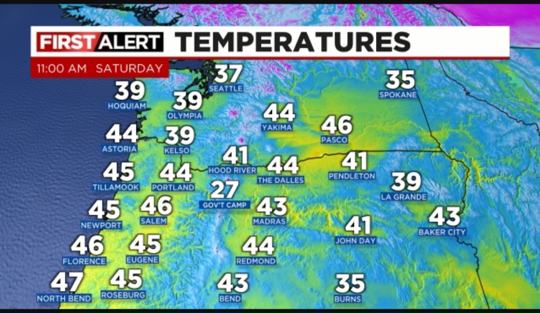
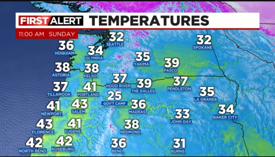
Many valley and coastal locations are running 3 to 4 degrees cooler than this same time yesterday, and in some cases even more. Expect additional cooling tonight which is why I’m slightly more confident in spotty light snowfall accumulations tonight through Tuesday. The forecast of nothing – 2 inches each night/morning remains on track with roads possibly being icy or snow covered during the nighttime and early morning hours. Roads during the day should be just fine. So far today we have seen now snow; however, Monday or Tuesday could easily be a different story. Hopefully that’s helpful in clarifying what is going on and what to expect.
The rest of the forecast below is just copied and pasted from Saturday’s post. I’ll try and have a fresh post either Monday or Tuesday.
Mon & Tue: A few snow showers are possible each morning. Some people will wake up to snow, some of us to ice, and some with mostly bare roads. Hard to pinpoint when we are dealing with showers. Snowy and icy roads should clear up by late morning each day. This means life should be able to go on as normal roughly 10am to 6pm each day. Nothing – 2 inches of snow possible each morning. Anything that falls out of the clouds during the daytime hours will be in the form of snow thanks to the cold atmosphere, but it’s much less likely to stick during the day unless you find yourself at a higher elevation.
Wed: More widespread snow showers likely. 1 – 4 inches of snow possible at any elevation and even during the middle of the day as colder air works it’s way south. Roads could be bad all day long Wednesday. Subject to changes still.
Thu: Back to sunbreaks & scattered snow showers. Another inch or two of snow is possible during this time frame, and colder temperatures will make it tough for roads to melt off.
Super Bowl weekend and the week after look cold. Way too far out for details, but strong signals that we remain in a wintry pattern with more snow opportunities likely to present themselves.

Hi Bryan,
Thank you for continuing to keep your weather site going after all these years! I always count on you to give us the best predictions, especially when “snow” is involved 😬..You are by far my FAVORITE weather man!!😊 I hope you and the family are doing well. I will be praying for a little snow for all of us❄️
-Melinda
LikeLike