
I have to tell you there has been a whole lot of confusion on the weather models over the past week. By the way, when I say weather or computer models I’m not talking about fancy dressed up computers walking down a catwalk haha. I’m talking about a set of computers that forecast or model out potential weather outcomes two to four times a day (depending on the model). Getting back on track, I have noticed a shift in the models over the past couple of days showing some much colder, possibly very cold arctic air coming right down into Oregon next week. In my previous two updates you may recall me using an awful lot of yellow highlighting on the extended forecast indicating a high amount of uncertainty. Over the past week or so the forecasts have been going back and fourth between really cold weather and more mild/spring like weather. As of this afternoon there seems to be fairly solid agreement that a much colder airmass is headed for Oregon.
It’s too soon for very many details which is why I still have yellow highlighting for the last two days. The main message is much colder weather is on the way, and with this cold air will come an increased chance for valley snow. I sense many more updates in the coming week or two…. 😉
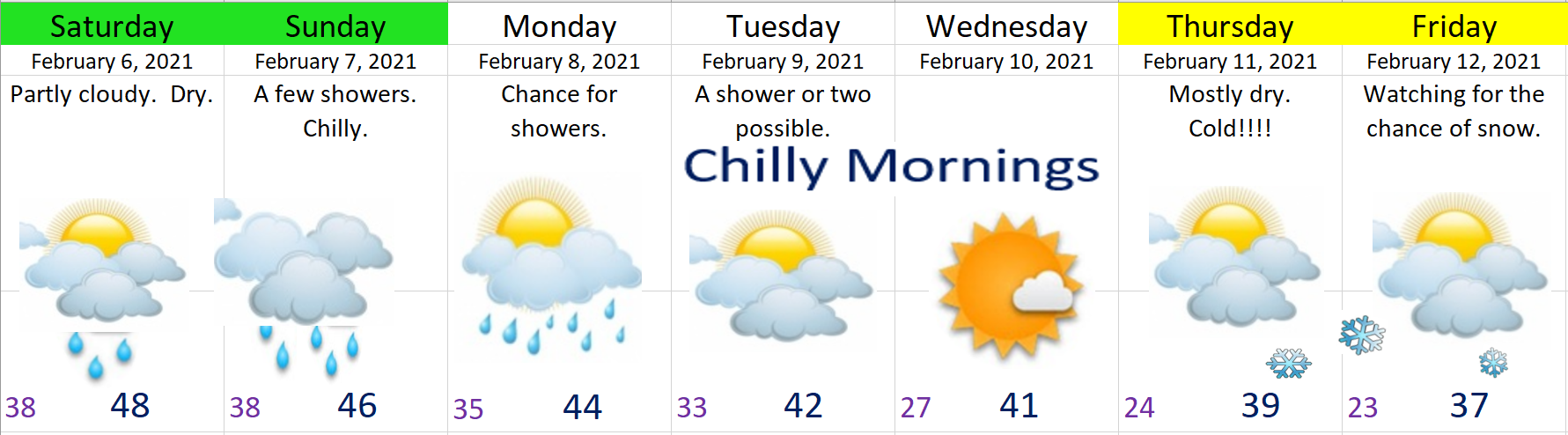
Here’s a few details and highlights for this coming week
1.) Saturday through Monday will feature a whole lot of clouds, but not a lot of precip. Basically a few showers each day with a couple peaks of sunshine here and there. We will also be getting progressively cooler each day with Saturday’s highs in the upper 40s. Sunday’s high temps will be in the mid 40s, and by Monday highs will drop down to the low to mid 40s.
2.) Tuesday through next weekend will no doubt be cold with lows possibly getting as cold as the upper teens. Brrrr!!! Regarding the chance for snow, there is still a lot up in the air right now. At this time I’m sticking with a mostly dry forecast, but don’t be surprised if a lot more snowflakes start showing up in the forecast. I’m watching Thursday through next weekend in particular as we could see a “classic” snowstorm setup with cold air in place and a storm system moving in to our south. In the past it is this setup which has typically produced our biggest snowstorms. Again, all possibilities for now, but it’s something I’m watching very closely!
THE CASCADES
Currently our snowpack is below normal for this time of year, and I don’t expect anything more than about 4 to 6 inches of new snow now through Monday which is not a whole lot. With that said, there’s still plenty of snow for skiing, snowboarding, snowshoeing, or whatever it is you do in the snow up there. 😉 As of this afternoon Hoodoo has a base of 67 inches which is still a decent amount of snow.
Of course, if a big storm does come in with the cold air late next week bringing snow to the valley, then I would imagine the mountains would also score some really big snow totals.
Happy Friday!!!!!

Thanks Bryan for all of your weather updates!! I always enjoy getting them😊
LikeLike