What was suppose to be an enjoyable week of late warm summer weather with highs in the 90s instead turned into a smokey and fiery hell leaving communities devastated along with a number of popular recreational sites, terrible air quality, and highs nearly twenty degrees cooler than what was originally forecasted due to thick smoke.
If you are looking for relief from the smoke it is still coming, very very slowly…… Our clearing out process will pick up a little on Sunday, at least up high. Down here in the valley we are essentially stuck in an inversion pattern still keeping the smokey air trapped near the surface until probably Tue when showers and rain finally move in. Of course with all the smoke and ash particles floating around in the sky this has the potential to be some of the grossest rain that has ever fallen here in western Oregon, so don’t go singing in the rain when it does arrive, at least not at first.
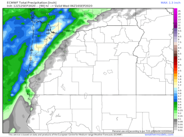
The rain will take its sweet time moving inland next week. The maps below show forecasted precipitation totals through Tuesday night and give a decent idea of what parts of the state will see rain first. In general places northwest of Portland, Salem, and down to Florence will receive decent rainfall Mon night and Tue while locations like Sweet home, Springfield, and much of the Santiam Canyon will sadly stay mostly dry with just a few sprinkles and isolated light showers until Thu. Of course if this storm comes onshore even a little bit further than expected then we would be looking at showers over those areas on Tuesday as well. Something we can be praying for.
Those maps depict pretty clearly a sharp drop off in precip/rainfall as one moves southeast. Fortunately by Thu afternoon and Fri all locations west of the Cascades will be seeing rain as showers become widespread across the region. Showers continue on Saturday and possibly even through next Sunday.


smoke be like cough cough
LikeLiked by 1 person