Fire weather update

I don’t have the latest numbers or maps on where the wildfires are burning or what locations are in need of evacuating. I’m learning that stuff as quickly as you all are and it is changing fast. What I can tell you is the winds should die down Thursday and even reverse direction a bit which will not only help clear some of this smoke and ash out (although it will take quite some time), but it will also help reduce and slow the spread of the fires.

The best news I can give you, besides the change in the winds, is that rain is finally expected to arrive Monday evening. In fact next Mon – Wed looks wet which should help put an end to any more significant fire threats. Of course Mon feels so far away right now, but it is better than not having any rain in sight. This map gives you an idea of how much rainfall we could be looking at next week. Lots of blue coloring over western Oregon indicating a solid half inch of rain or more. Good news for fighting the fires, and it sure as heck can’t come soon enough…

This satellite loop shows how the winds are driving thick smoke right into the valley.

I hope you all are staying safe and staying alert. There are what feels like an infinite number of sources to keep you up to date, so make sure you have one that is specifically for your local area to help minimize confusion.

Bad news

It’s hot out there, especially for September, and now we are about to add to the mix some strong winds which is really bad news for the wildfires currently burning here in Oregon. Winds pick up later this afternoon and will continue through Wednesday evening before finally dying down.

Here in Salem you can expect gusts around 25 to 35mph, maybe an occasional gust closer to 40. If you’re headed into the Cascades, the Coast Range, the gorge, or to the Portland area – so pretty much everywhere else in Oregon lol, then you could be looking at gusts over 50mph!

In case you missed the memo, this will be a warm wind and not the “cool you off” type of breeze we so often get. The next 7 days will be hot and well above average with a shot at going above 90 almost every single day this week and still no sign of rain. Enjoy the warm weather and pray for no new fires.

Hotter times are coming

Another stretch of above average temps will arrive tomorrow and will last through Wednesday of next week.

7.24.20

As you can see, plenty of hot weather, and aside from a very slight chance for a shower or two on Thu & Fri, no decent shot at rain in sight, and if we look even further out it appears as though August will start off on the warm and sunny side.

The Cascades and Central Oregon

Thunderstorms are possible in the Cascades Mon – Wed with the threat extending into Central Oregon Tue & Wed.  This could spell bad news for wildfires as we have been dry now for awhile.  Here’s a look at our current drought status.  Most of the state is running below normal in regards to precipitation.

OR drought 7.24.20

Central Oregon Coast

The forecast for the coast in summer can be so dang tricky, but I figured I ought to give it shot just in case any of you are fortunate enough to make it over there.  😉  Sunday should be the warmest day along the beaches with close to full sunshine, but it will likely be fairly breezy.  Mon and Tuesday will likely be much cloudier and consequently a bit cooler, but not quite as windy.  Slight chance for some light rain showers Thursday and Friday along with even cooler temps.

There you have it!

ENJOY!!!

Quick update

Wintry weather is still on the way and there are a few changes to highlight.

First big change: the odds of accumulating snow Monday night through Tuesday morning have increased a bit since my last update.  It’s looking more likely that we will see a snow day on Tuesday.  Not a slam dunk yet, but higher chances than what was indicated in my previous update.

Second big change: the Wed/Thu storm has been trending more like a quick hitter meaning a snow day Wednesday is still fairly likely, but by Thursday morning it’s possible we switch to southerly winds for a quick warmup.  This storm is several days away still, so I expect this to change at least a few more times before landing on a final solution.   I should have a much better idea of what will happen for this storm by Sunday night.

Meanwhile the Cascades are just getting dumped on.  Hoodoo has over 50 inches of snow currently which is a lot considering one week ago they only had 15.  Heavy snow will continue pretty much nonstop now through Tuesday with another 3 or 4 feet falling at pass level.  Here is what the chain up area looked like around 3:00pm:

Snowy pass 1.11.20

A more detailed update later tonight with specifics concerning Monday and Tuesday.

Wild Weather

Growing confidence this morning that we will see significant snowfall here in Salem next week.  I have our day by day forecast below and then some possible plot twists, but first, a couple of things to keep in mind going forward.

1.)  Your day to day life will probably be impacted by snow next week.

2.)  Details will likely change a number of times before this actually takes place,  This is simply my best guess as of now, and I would never give my loyal followers nothing short of my best! 😉
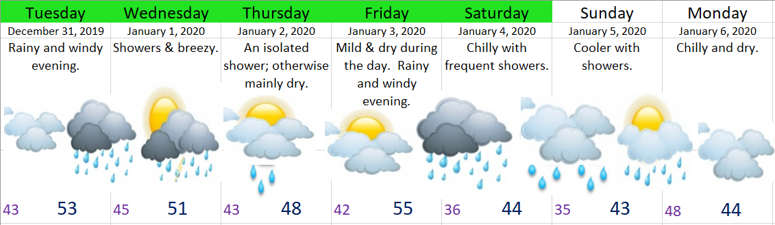
EXTENDED FORECAST

Today:  Gusty winds increasing in strength during the late afternoon.  Gusts up to 40mph by evening time.  Rain will move in late afternoon/early evening.

Sat & Sun:  Rainy and breezy.  Gusts generally 25 to 35mph.

Mon:  Wet snow showers through the day.  Very slushy accumulations possible just about anywhere, but higher elevations stand a better chance of picking up an inch or two.  This not looking like a snow day.  Normal life (including school) will go on relatively unaffected by snow as most of this snow will melt upon reaching the ground.

Tue:  Snow showers and sunbreaks with a dusting to 2 inches possible just about anywhere.  More snow the higher up you go.  School delays seem possible, but a full on shut down doesn’t look super likely at this point in time.  Temps won’t make it out of the 30s.

Wed:  A dry start to day with snow moving in sometime during the afternoon or evening.

Thu:  Snow and possibly some freezing rain much of the day long.  A classic winter storm setup for the mid valley.  Feeling pretty confident Thursday ends up being a snow day (possibly Friday as well).  Highs Thursday close to 32 degrees.

Possible plot twists

1.)  I’m watching a storm coming in Monday night that could give us a significant amount of snow if things line up just right.  Currently I’m not sold on the idea yet…  Just keep in the back of your head the possibility of Monday night/early Tuesday morning being snowy.

2.)  Snow is almost certain at this point with the Wed/Thu storm.  Question is, will this be a couple of inches type storm that is over fairly quickly, or do we get slammed with 6 plus inches of snow?  Hard to have a good idea this far out, but 2 – 3 inches seem likely at a minimum.

3.)  The timing of the Wed/Thu storm is still very much in the air.  Several forecasts have it stalling out giving us snow from Wed late morning until Friday, some have it moving through much quicker, and some have it not moving in until Thursday morning.  LOTS can and will change with the timing of this storm.

The Cascades

While we are getting rain this weekend, the Cascades above 2500 – 3000’ are going to be hammered with feet of snow and blizzard like conditions.  Not a good weekend at all to travel the Cascades.  If you must travel then expect possible road closures and very slow traffic as we are talking upwards of 5 feet of snow now through Monday morning!!

I’m just amazed at how much snow is forecast to fall up there, so be prepared with chains and everything else you need to stay alive in your car should you find yourself stuck up there for several hours.

There you have it.  I’ll probably have another update either later today or tomorrow.With each update from here on out I should be able to add both more details and higher levels of certainty to the forecast.

My “Winter is coming” post

Brace-yourself-Winter

I don’t care if I have used this picture a hundred times it’s still one of my favorites, and it pretty accurately depicts how I’m feeling this morning with the potential for lots of cold and snowy weather here in western Oregon.

First we need to get through a couple of very wet storm systems.

Friday:  Rainy weather should arrive during the later part of the afternoon.  Wind gusts of 30 to close to 40mph are possible Friday and into early Saturday morning.

Saturday:  Periods of rain and breezy.

Sunday:  More rain and wind.  Very stormy.

Rainfall totals for the weekend look to be around 1.5”.

CASCADES:  Incredibly snowy above 3000′ with 2 – 4 feet of snow now through Monday.  We are making up snowfall totals up there like no one’s business, and it’s awesome to see!!!

Okay, now the fun part.  I’m still going to be skimpy on details because, well one because I have been busy with the job that actually pays the bills, and two we all know how tricky it is to forecast snow accurately around here specifically several days out. 

Main take aways

High confidence we:

1.)  See at least some amount of accumulating snow.  I know we all want more details than that, but like I said, details and amounts are very tricky to predict this far out.

2.)  At least 1 snow day for school faculty (and students).  I’m going to be in deep with the sharks if this one doesn’t happen lol… 😉

3.)  The coldest air of the winter.

Some things I’m watching (lower confidence)

1.)  A major snowstorm for the mid valley – major meaning several inches of snow.

2.)  Things go to pot and we get screwed with rain/snow mix.  Very unlikely, but this is Salem, it has happened before, and I know that if there is one city in Oregon that would miss out the most on snow it would be good old Salem, OR…..


Look for more updates possibly as early as tonight.

Wet start to 2020

We have a rainy and windy evening on tap to help ring in the new year.  It’s already breezy out there and those breezes will slowly increase through the day.  Here’s what the next several days look like.

12.31.19

Highlights

Wed:  Showers.

Thu:  A mostly dry day.

Fri:  Dry and fairly mild (for January standards).  Rainy and windy evening.

Sat & Sun:  Showery and chilly.

Mon:  Cool & dry.


Cascades

Wed:  Snowy with 4 – 10 inches of snow above 4000’.

Thu & Fri:  Good traveling weather with dry conditions.

Sat & Sun:  Very snowy with snow levels down to 2000’ or even a little lower at times.  12 – 18 inches of new snow.

Mon:  A couple leftover snow showers, but drying out.

Have a fantastic and safe day!!