Midweek update

Another stormy day out there today. Winds have not been too crazy with gusts no higher than 30 -35mph, but plenty of rain. As I write this we have a band of rain rolling through with a peak of sun making for a pretty neat to scene. 🙂

Wednesday & Thursday: Showers & sunbreaks, breezy at times with brief downpours. Maybe even a thundershower or two with some small hail mixed in. Wednesday will be the wetter of the two days.

The Cascades

Snow levels fall down below pass level late tonight. 10 – 15 inches of new snow for ski resorts by the time Friday rolls around. Since I don’t have my own graphics department lol, I borrowed this from Mark Nelson at Fox 12 Oregon. You can see just how healthy the snowpack is compared to the past 10 years for this early in the season.

Friday & Saturday both look dry, so a nice two day break from the rain before another system rolls in on Sunday. I should note there will be a fair amount of fog and clouds on these two dry days – not exactly a super sunny period, but dry nevertheless.

Thanksgiving week is the week after (already!!!) and it’s looking stormy and wet with more mountain snow & valley rain.

According to plan

Fox 12 Weather provided this nice graphic showing peak wind gusts from our storm Friday morning.

My forecast of 35 – 50mph turned fairly well and in the tricky world of forecasting I will jot this down as a win. 🙂

Storm number two is rolling in now. The rest of today is going to be very wet with steady rain increasing through the day and turning heavy tonight. Expect well over an inch of rain to fall by this time tomorrow. Southerly winds pick up tonight as well with gusts 30 – 40mph.

The Next 7 Days

1.) Sunday still looks like the calmest day with scattered showers, sunbreaks, and fairly light winds.

2.) Monday: Rainy through the early afternoon. Mild and breezy. Temps will likely top out around 60°.

3.) Tuesday: Still watching the potential for another round of strong winds and heavy rain, but lots still up in the air with this system. Very stormy along the coast.

4.) Wed & Thu: Showers, breezy, and lots of mountain snow. Assuming businesses are allowed to operate, ski resorts should have one of the best starts to the ski season in years with close to 30 inches of snow currently being reported at Hoodoo and more on the way later this week. There will be some melting Sun – Tue with the milder weather, but overall it looks like we are off on the right track in the snowpack department!!

Have a fantastic weekend!

Stormy weather

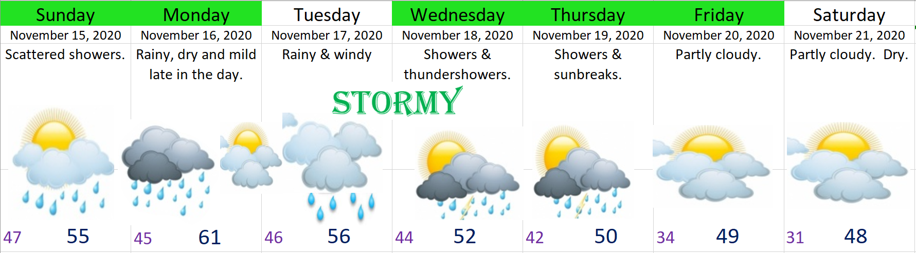
There is a lot going on in the weather department, so let’s jump right in.

1.) Tonight/Friday, windy with heavy rain at times transitioning to showers during the afternoon. Maybe even a late afternoon thundershower. Gusts should top out around 40 – 50mph which is not super “wild”; however, that’s stronger than any storm we saw last winter. Expect a few power outages.

  • Rainfall will end up over an inch by the time Saturday rolls around which means localized areas of minor flooding is possible.
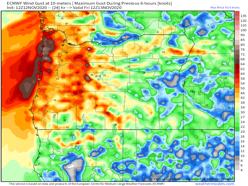
  • This chart shows peak wind gusts in knots at 4AM Friday morning. The 47 over Salem translates to 54mph which I think is a little overdone, but we will see. Either way it’s going to be quite windy tonight and Friday morning.

2.) A second (not as intense) round of rain and wind moves in Saturday afternoon/Saturday night. Gusts with this storm will be closer to 25 – 35mph.

3.) Sunday will be a sort of in between day with both a few showers and a few sunbreaks at times. Sunday night – Monday more rain & wind. This third storm contains a lot of moisture. We could easily see well over an inch during this timeframe. Will monitor this storm also as time gets closer.

4.) Yet another strong storm is possible Tuesday & Wednesday bringing the potential for more heavy rain and strong winds.

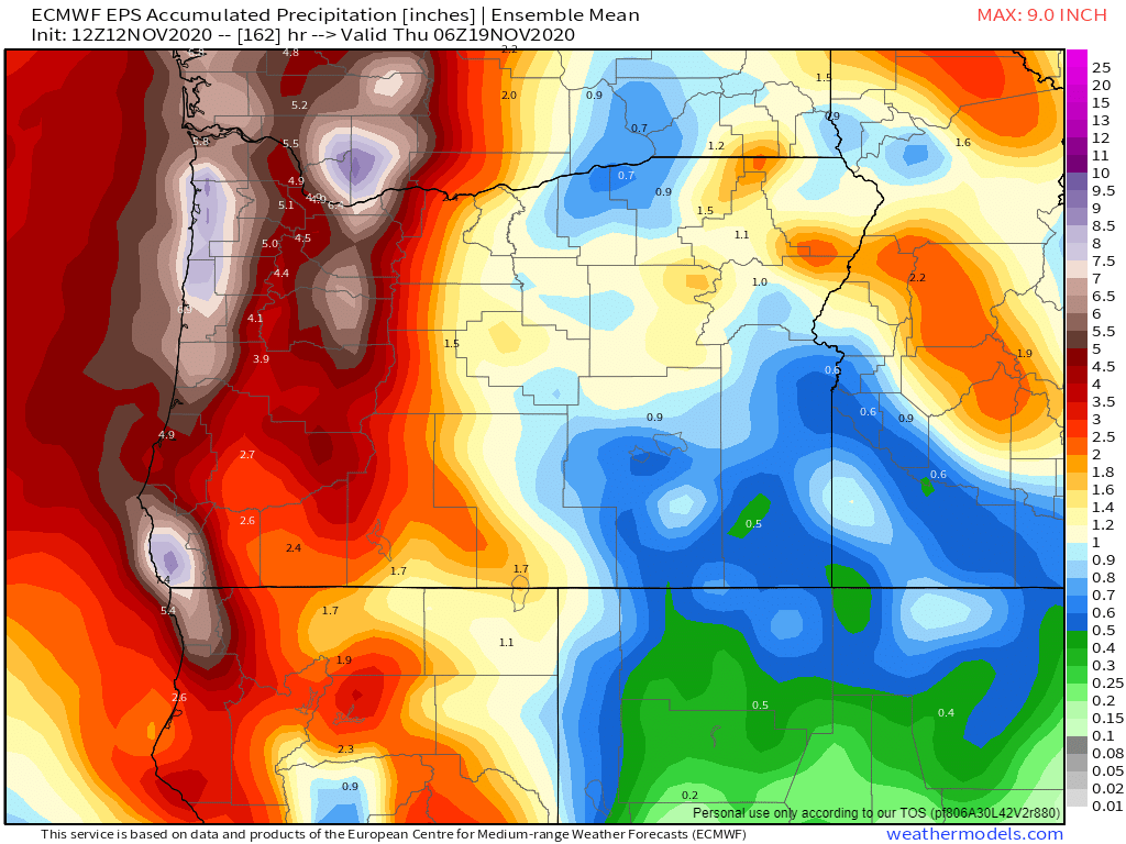
5.) Over 4 inches of rain are forecasted by next Thursday morning. Even if this is overdoing the rainfall by an inch we still have an extremely wet stretch of days ahead.

THE CASCADES

Very poor travel weather starting late tonight through Saturday night with heavy snow and high winds. Great snowpack building weather though with 18 – 24+ inches of new snow falling, but terrible if you wish to travel over the passes. Much better conditions on Sun & Mon.

THE COAST

  • Along the Oregon coast expect lots of big waves, like 40 plus foot waves at times, powerful winds, and high surf to be the rule of thumb over the next week or so. Add in some heavy rain (3 – 6+ inches over the next several days) with the high surf, and coastal flooding is going to be an issue in places.
  • Sunday looks to be the calmest day, and even that day will prove to be showery and breezy at times, but with a few glorious sunbreaks scattered in between.
  • Wind gusts will also be higher at the coast, as is usual, gusting 60 to 70mph with this first system. Gusts above 50 are likely with some of next week’s storms too.

Like I said, lots going on. Okay, happy Thursday and stay safe!!

Election Day 2020

We finally had some rain today after a very dry October. Looking ahead we have a bit of weather action coming up this week to cover including some mountain snow.

Highlights

1.) Thursday & Friday will be especially wet. Expect a little more than an inch of rain over these two days.

2.) Much cooler weather. Highs will be in the 40s Sun – Tue and lows will once again drop into the 20s Monday morning.

Here are a couple of maps showing both the total precip and total snowfall measured in inches through Saturday night. Main take away is it’s looking wet down here and snowy up in the Cascades with generally 10 to 15 inches expected starting early Friday morning as the snow level slowly drops down to near 3000′.

I’m very glad to have you all as faithful followers. You may notice I avoid posting anything political in my forecasts, or at least I try to. My desire is to keep it that way as it’s extremely nice for a change reading about something that isn’t political, polarizing, frustrating, or upsetting as most political things are; however, I think active involvement in our system is very important, so if you have not voted yet, be sure to fill your ballot out and drop it off by 8pm tonight!!

Okay, take care, happy election day, and remember, at the end of the day we are all still God’s children. 🙂

Rainy and Breezy

We have a good old fashioned fall storm out there today. Breezy south winds have been going all day and the rain won’t be too far behind. I imagine the rain will get going here in Salem between 2 and 4pm. Expect the better part of an inch of rain to fall with this storm along with more gusty winds.

Thursday’s weather will feature showers and thundershowers. Thundershowers are most likely north of Salem and along the coast; although anyone could see a few brief downpours or small hail with the “regular” showers tomorrow.

Showers stick around for both Friday & Saturday with Friday being the wetter of the two days.

I’m still feeling confident Sunday will kick off a nice stretch of late season sunny and warm weather with highs next week reaching well into the 70s & 80s. The best part about it is we will actually be able to enjoy the nice warm weather this go around since most of the wildfires around here will be on life support thanks to both the coming rainfall and the continued hard work of the firefighters who are still out there working on these fires.

The Oregon Coast

The largest waves of the season will arrive today with waves heights of 20 – 25 feet expected this afternoon through Friday. Not exactly the biggest waves ever, but definitely the largest so far this season. Will make for some fun storm watching weather should you find yourself at the Oregon coast.

The nice weather next week won’t be limited to the valley. Warm, sunny weather is expected along the coast with Tue – Thu being the nicest days and highs in the mid to upper 70s. Winds may still be breezy at times next week with the warm weather, but let’s be honest, when are they not breezy out there? 😉

Busy week ahead

Well, we have another busy week in store as we slowly clear out of this smoky mess, plus we have a chance for thunderstorms this Thu & Fri. First things first, with no significant winds in the forecast in the near future it’s looking like the smoke will be with us to some extent now until Thursday. 😦 It should improve a little Mon night and Tue, especially in the locations that get some good rain showers, but a change in the winds aloft (up high) will likely bring more smoke back into our region on Wed…

My thinking hasn’t changed in terms of who gets rain Mon – Wed and who doesn’t. Showers will generally be confined to locations along & west of I-5. Many places in the Santiam Canyon and eastern Willamette Valley will not see much in the way of rain until Thu. Below is the latest total precip forecast map which goes through Wednesday.

The coast & Coast Range get around an inch of rain and Salem receives nearly half an inch while locations like Detroit, Mill City, Lebanon, and Sweet Home see little more than a few sprinkles. This next map shows estimated precipitation totals through Saturday night. The second half of the week is definitely looking much wetter for those eastern locations.

Extended Forecast

The key thing to remember is that for Mon – Wed the potential for rain increases quite a bit as one heads further west, and it won’t be until Thursday when rain showers finally move through the entire region giving everyone a decent soaking.

The other highlight for this week is the chance for thunderstorms both Thu & Fri. Fortunately there should be plenty of rain (maybe some hail as well) with these storms limiting any new fire threats from lightning.

Hang in there and stay healthy…

Sept 12th update

What was suppose to be an enjoyable week of late warm summer weather with highs in the 90s instead turned into a smokey and fiery hell leaving communities devastated along with a number of popular recreational sites, terrible air quality, and highs nearly twenty degrees cooler than what was originally forecasted due to thick smoke.

If you are looking for relief from the smoke it is still coming, very very slowly…… Our clearing out process will pick up a little on Sunday, at least up high. Down here in the valley we are essentially stuck in an inversion pattern still keeping the smokey air trapped near the surface until probably Tue when showers and rain finally move in. Of course with all the smoke and ash particles floating around in the sky this has the potential to be some of the grossest rain that has ever fallen here in western Oregon, so don’t go singing in the rain when it does arrive, at least not at first.

The rain will take its sweet time moving inland next week. The maps below show forecasted precipitation totals through Tuesday night and give a decent idea of what parts of the state will see rain first. In general places northwest of Portland, Salem, and down to Florence will receive decent rainfall Mon night and Tue while locations like Sweet home, Springfield, and much of the Santiam Canyon will sadly stay mostly dry with just a few sprinkles and isolated light showers until Thu. Of course if this storm comes onshore even a little bit further than expected then we would be looking at showers over those areas on Tuesday as well. Something we can be praying for.

Those maps depict pretty clearly a sharp drop off in precip/rainfall as one moves southeast. Fortunately by Thu afternoon and Fri all locations west of the Cascades will be seeing rain as showers become widespread across the region. Showers continue on Saturday and possibly even through next Sunday.