Heavy rains, flooding next week

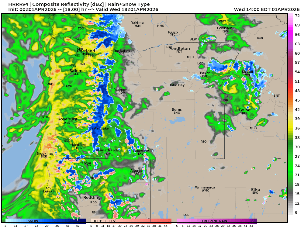
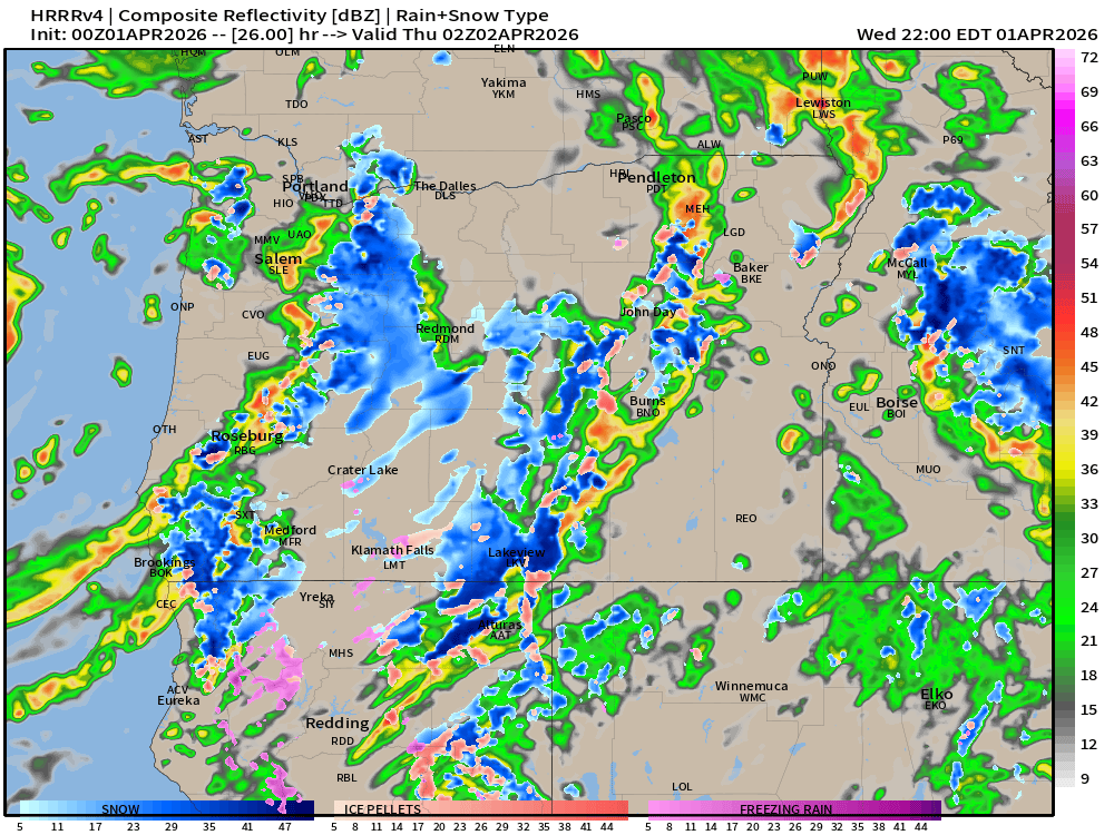
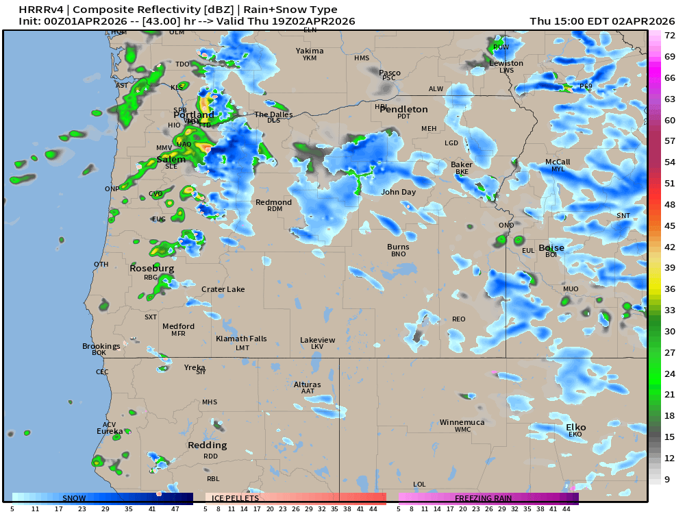
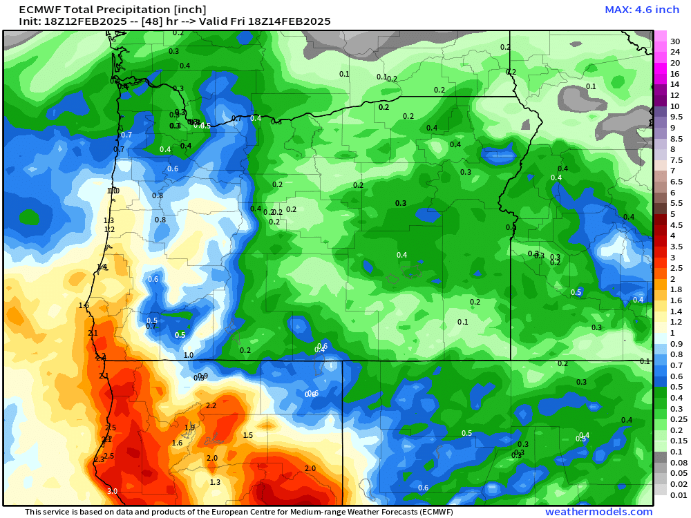
It’s been a busy day for me looking over flood maps, rain charts, and different forecasts. Needless to say, we have some very heavy rain on the way, and not only heavy, but prolonged too with some flooding looking very likely now. Details below:

The quick version

Typical rainy weather continues now through Monday, and by this I mean periods of rain or scattered showers. Some brief periods of moderate to heavy rain, but no threat for flooding during this time frame. Between now and Monday afternoon I expect around 1 – 1.5 inches of rain in total.

Monday night through Wednesday: Steady rain during the majority of both these days with frequent periods of heavier rain. Winds will be pretty gusty at times throughout this period too. I’m thinking gusts 35 to 40mph. Not real strong, but if soils are saturated, and they will be, I could see a few isolated instances of trees coming down here in the valley and along with those trees, some power lines. Please be prepared for some power outages next week.

Extended forecast

We are approaching the event and close enough to share some estimated rainfall totals. I’m thinking Salem easily sees over 2 inches between Tuesday and Wednesday alone, and this could be a rare time where we see upwards of 4 inches within a couple of days. Depending on which side of these totals we end up on, we could see some real serious localized flooding on the small creeks around town.

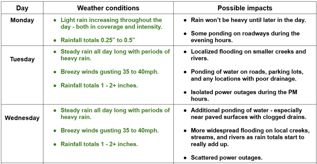
Remember, in situations like this conditions can vary greatly depending on location. My forecasts are typically centered around Salem, but generally can be used and are valid for locations like: Monmouth, Independence, Albany, Silverton, Wilsonville, Canby, and any locations nearby or in between. This next graphic shows my thoughts for this region for Monday – Wednesday.

This next graphic covers flood risk for local rivers. There are many more creeks and rivers around our region than I had time for, but this should give you a good idea of what to expect.

If you live near any sort of creek, river, flood basin etc. that is not listed, then you should be paying attention to water levels and hopefully you can sort of estimate what might happen based on the information I’ve provided.

For the most part, expect smaller creeks to rise quickly during the midst of our rainstorm next week, but those same creeks should fall shortly after the heaviest rains end. The mid sized streams and rivers take longer to rise to flood stage which is why most of those may not flood until late Tuesday night or Wednesday.

I still do not expect the Willamette River to flood. It will of course rise a lot, and I could see River Road heading out towards Independence closing (maybe), but there is just no snowpack to melt, and the Cascade reservoirs have a ton of storage capacity right now. Our biggest floods historically have always happened when we have a large snowpack present in the Cascades, and (typically) when the reservoirs are already closer to capacity. Those two factors are really going to save us from what could have been much worse flooding this time.

The coast and Coast Range

Stormy! Not necessarily super strong winds or huge waves, but the combination of the heavy rain, gusty winds, and higher than normal waves for several days straight will make for wild times along our coastline. Rain totals of 5 to 8 inches are likely over the next five days, wind gusts of 40 to 50mph Monday afternoon through Wednesday night, and at least some flooding is likely on most of the coastal rivers.

Phew! There’s a lot going on next week, and winter is still young, so I’ve created a Discord server with several “channels” on it. On Discord you will find a channel where you can share questions, comments, or your current weather conditions. There is a “photos” channel designed for easily sharing weather related photos. I’ve also added a couple of channels for linking these “Bryan Weather Alert” forecasts, and lastly, I added a channel which will be great for sharing quick, but important updates to the forecast! It should be a lot of fun, an easy place to finally share weather related photos together, and a great way to engage as a community a little.

Please feel free to join the Bryan Weather Alert community on this newly created Discord server! Bryan Weather Alerts on Discord

Take care, and stay safe out there! I’m certain I’ll have more updates in the next few days.

Looking towards Thanksgiving

Things have been real mellow around here, and up until the past couple of days, it’s been quite mild too. Salem achieved a record high of 65° this past Saturday. The only thing that has really changed from this week compared to the previous week are the cooler temperatures. We hit the 60 degree mark eight days this month, but since that record high on the 15th, we have been in a cooling trend. Salem finally got down to 32° this morning for the first time this fall, and we never broke out of the 40s. Inversion season is definitely here!

The main message is that there are still no big storms on our horizon. No flooding scenarios, strong winds, chances for snow etc. Just more of the same: a little rain at times, some fog, and a few sunbreaks. The riveting details are below:

Tonight: Light rain switching over to scattered showers overnight. Chilly with temps in the mid to low 40s. Brrrrr!

THU: A few showers early. Dry afternoon and evening. High of 54°.

FRI & SAT: Dry. Fog seems very likely both days with a few sunbreaks possible during the afternoons. Highs in the upper 40s.

SUN & MON: Some rain both days, but nothing big or major that would cause significant issues for our day to day lives.

Looking ahead to the days leading up to Thanksgiving, and Thanksgiving itself, I continue to see no big storms. Maybe some mountain snow to deal with, but will have more updates again as we get closer to the holiday. The main message is that this rather calm weather pattern appears to continue for another week.

Warm Novembers

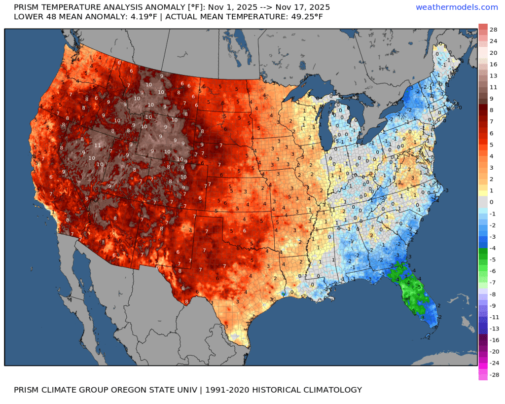
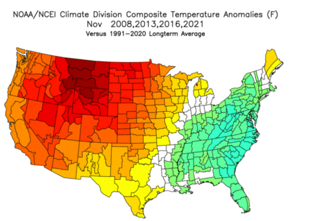
We have had a very warm November so far running almost 4 degrees above normal! Check out this map showing temperature departures from average so far this November.

Very warm in the west, and cooler along the east coast. Well I’m here to tell you that warm Novembers do not correlate to warm winters. In fact, maybe quite the opposite. Below I’ve charted temperature departure maps from four different years. All four of these years had similar La Nina conditions to what we have now, and all four of these years had very mild November temperatures – also very similar to what we have seen so far this November.

Looks similar right? Very warm out west and cooler along the east coast. Well, what happened after each of those warm Novembers? This next chart shows temperature departures for December through February from all four of those same years.

As you can see, the rest of those winters actually ended up on the cooler side. In some cases significant cooldowns occurred which lead to valley snowfall. How many of you remember December 2008 when it snowed several times in the weeks leading up to Christmas? Or December 2016 when it snowed several inches leading to an early Christmas break. Point is, a warm November does not equal a warm winter. If you could only see some of the comments in the weather forums I’m in then you would be laughing yourself to sleep. People claiming winter is over, others saying things like it’s difficult to imagine even the ski resorts getting enough snow to open this winter, and other super ridiculous nonsense.

We could end up with a dry and mild winter (has happened before, and it will happen again), but I’m not real worried considering it’s only the 19th of November, and again, the data I just shared indicates that warm Novembers do not necessarily lead to warm winters. Let’s see what happens…

Enjoy the rest of your evening and stay safe out there!

The next nine days

Can you believe it’s almost Friday and the end of October? Time to look ahead at the forecast for this weekend (many of you want to know), plus the forecast for next week, and at the very end I have a fun little weather history tidbit for you.

I’ve combed through the weather models searching and searching and I cannot find a single completely dry 24 hour period after Friday through at least the next ten days! Eventually we’ll see dry weather again, it always comes back, but it’s very clear we are entering full on rainy season mode here in western Oregon. We have a lot of rainy, grey, and damp November weather on tap with only very short respites here and there.

Extended forecast

Highlights

Friday: The first half of the evening looks dry . Late evening activities could get rained on. Rain will begin earlier in the evening the further northwest you go. So the Portland metro could see a rainier Halloween evening than Salem. Locations south and east of Salem could easily stay dry well through midnight. If you’re wondering why apps keep on changing their forecasts for this Friday it’s because it just doesn’t get much closer than this. The estimated radar image for 8pm Friday night shows a band of rain just to our northwest. Move that sucker 25 miles closer and we have a very wet evening. See how tricky that is?

Saturday: Wet with rain much of the day.

Sunday: This is it! It could be mostly dry during the daylight hours Sunday, so take advantage of it! 🙂

Mon – Tue: Wet at times, but nothing real wild.

Wednesday: This storm looks a little more impactful with heavier rain likely, and possibly some gusty winds.

Thursday & Friday: It seems like another pretty wet storm system will move in at some point during these two days bringing steady rain and possibly more gusty winds.

Impacts

None of the storms this coming week appear capable of producing really strong winds. Instead plan on typical run of the mill 30 to 40mph gusts. Should this change, then I would of course do my very best to inform you. Right now the biggest issue weather will have on your day to day life (other than getting soaking wet outside) is the likelihood of clogged/backed up drains creating ponding on roadways and in some parking lots. As far as mountain snow goes, well I don’t see very much at all over the next 8 days. These storms will be on the mild side. This means wet and rainy Cascade passes.

Some fun weather facts for you all. I looked back into the history and record books, and I found out that in 1935 it snowed 5 inches officially at the Salem Airport on Halloween making it the earliest snowfall in Salem on record.

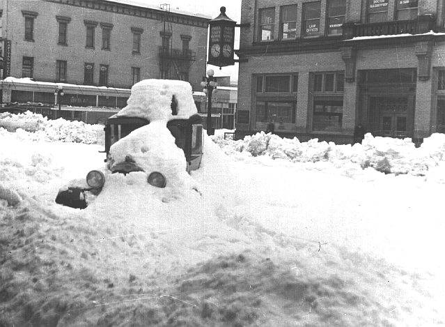
As far as the single snowiest day in Salem’s recorded history goes, it appears the record was set in 1937 when 25 inches fell between January 31st and February 1st. There are several documents (journals, weather reports etc.) indicating that up to 33+ inches fell in parts of south Salem in just those two days alone! Check out this photo from downtown Salem after the storm. Keep in mind this all happened after 6 to 12 inches of snow had already fallen during the week prior.

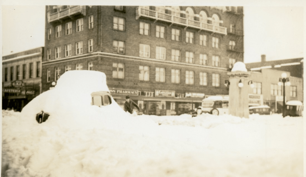
And this next photo was taken on State Street in downtown Salem after the storm.

What would happen if that took place today?!?!? I suppose every winter brings with it new opportunities for something wild to happen, and since Friday marks the earliest snowfall on record here, I figured it’s time to start keeping an eye out for snow…. Or, we could end up with a snowless winter which happens far more often than big snowstorms around here. :/ Time will tell…

Okay, stay safe out there, remind your kids to be respectful and mindful of people, property, and cars when running around from house to house in search of candy (sounds a little weird when you think about it lol), and of course, have fun! 🙂

A weekend soaking and look ahead

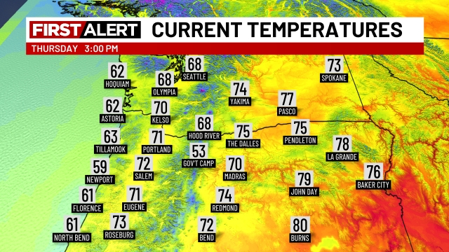
It’s a beautiful Thursday afternoon and temperatures are in the low 70s here in the mid Willamette Valley. I have a short update on our wet weather plus a look into next week and beyond below.

The forecast

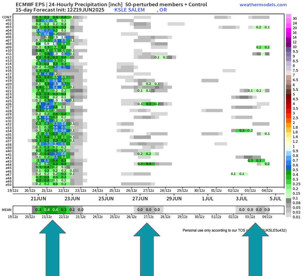
Our wet weekend is still very much on track. This weekend’s showers and rain show up very nicely on this ensemble chart. Remember, time goes from left to right on here and each horizontal line is a predicted outcome, and in this case, the outcome is precipitation. When viewing these charts we look for general agreement and trends.

Besides the soaking rain this weekend, you can spot the real light rain/sprinkle chance showing up for next Thursday (the 26th). I also noticed a higher than usual number of ensembles predicting a little bit of rain maybe the first few days of July. I’ll keep a close eye on that.

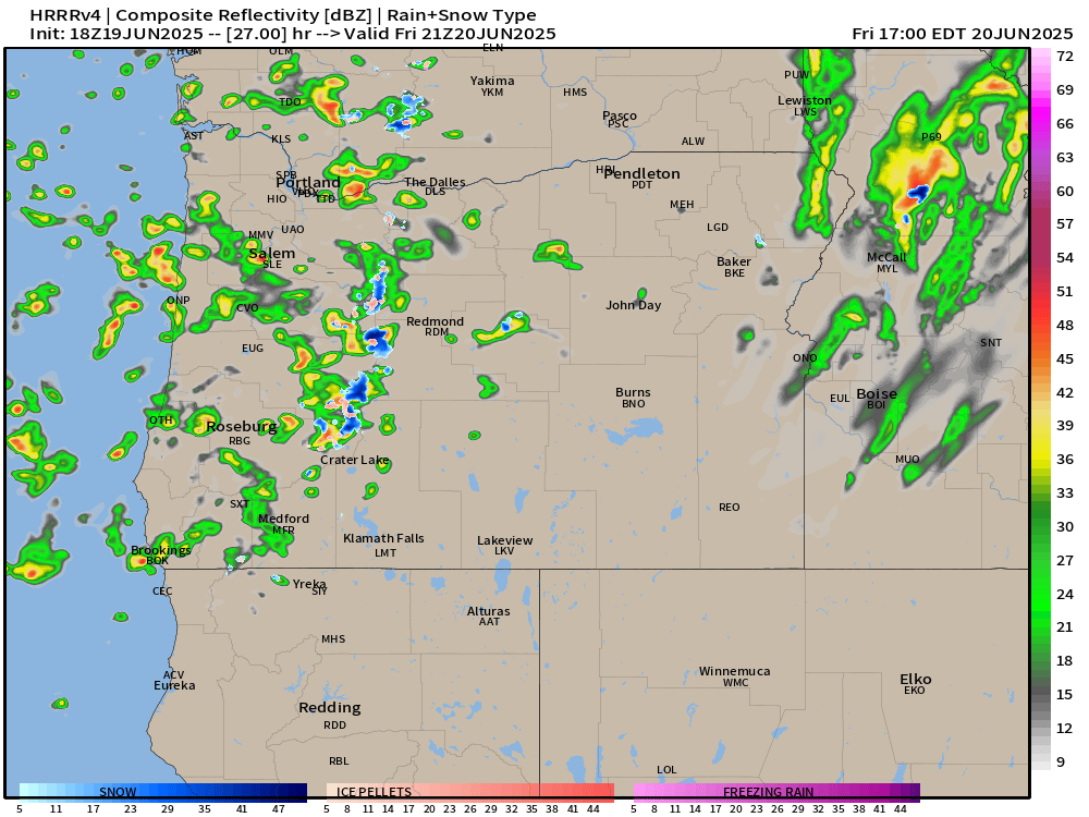
Friday will feature showers with just a few sun breaks here and there between showers. Quick hitting thunderstorms and heavy downpours are possible for all valley locations. The simulated radar image below does a good job depicting this scenario around 2pm Friday.

On Saturday we will actually see some steady rain during the morning/early afternoon hours before transitioning to a few showers later in the day. Again, downpours are definitely possible for all areas west of the Cascades. Steady rain will make it hard for high temps to top 60°.

Sunday: Expect this day to be mostly dry, but an isolated shower or two will require people outdoors to keep an eye to the sky. Overall a much better day weather wise for outdoor activities. Highs around 71°

Mon & Tue: Partly cloudy (more clouds during the morning hours) with lots of afternoon sunshine. Highs 80 to 83°

Wed: Increasing onshore flow again will lower highs back into the mid 70s with partly cloudy skies.

Thu & Fri: Could see another sprinkle or light shower (similar to what we just saw this past Wednesday) at any point during this time frame, but especially Thursday morning. Highs in the mid low to 70s with sun breaks mixed in.

Sat – Mon: June will finish on a warm note with highs in the mid to upper 80s and mostly sunny! A huge contrast to what we will experience this coming weekend.

Take care, enjoy the west weather the best you can, and don’t forget to pray for the people God puts on your heart today. Our world could use more prayer right now.

A very dry spring with rain on the way

It’s been a long time since I posted. The weather has generally been extremely uneventful, plus I’ve been busier than usual with work and side projects (including the garden). Regardless, I figured it was time for an update.

The forecast

Wed & Thu: Onshore flow increases pushing in a stronger marine layer along with a very weak front. This will result in highs in the low to mid 70s. Expect plentiful AM clouds with PM sun breaks. We could see a sprinkle Wednesday morning; otherwise, these two days will remain dry.

Fri: PM showers. A cold atmosphere up above will result in the possibility of thundershowers too. Some of the downpours could be quite heavy. Highs right around 60°.

Sat: Additional showers and thundershowers with a more steady rain likely during the late afternoon and evening hours. This will produce a widespread soaking rain for areas west of the Cascades. Downpours will have potential to be heavy. Highs will struggle to reach 60°

Sun: Showers wrap up with much of the day being dry. Just keep in mind that showers could still take place during the day on Sunday. Highs into the lower 70s again.

Mon – Wed: Partly cloudy to mostly sunny skies. Highs around 80° each day. Lows will start out chilly right around 50 to 53°.

Rain totals look to range from half an inch to just over an inch of rain here in the Willamette Valley. This will bring much needed precipitation to our region!

Aside from the first week of April, we have been unusually dry this spring. The few “rainy” days we have seen the past 8 weeks have not produced more than a third of an inch on any given day. The map below shows percent of normal precipitation locations have picked up between April 18th and June 17th. Many valley locations are running at a mere 15 to 25% of average.

We are running slightly better precipitation wise than the dry and hot spring of 2021. That year brought our most intense heatwave ever with temperatures soaring above 110° throughout the Willamette Valley. That was an awful experience. Luckily, no signs of hot weather.

As far as temperature goes, May 2025 went down in the history books as only being 0.2° above normal. For all practical purposes that’s considered average. At the moment, June is running 3.5 degrees above normal, a special thanks to the hot spell last weekend. That number will fall dramatically by this time next week due to the much cooler weather moving in.

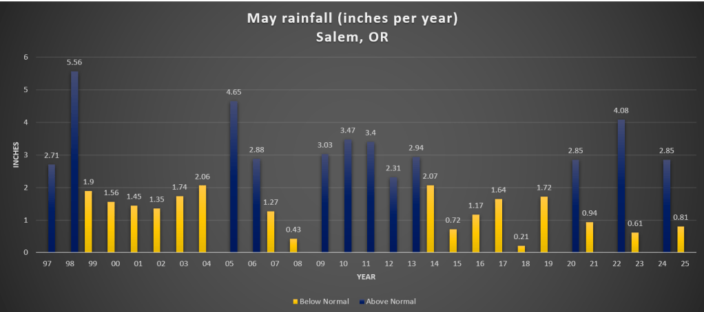
For reference, I added a chart showing total rainfall for Salem during the month of May going back to 1997.

There is no clear trend here. The only notable thing I could see was the tendency for totals to range more drastically over the past several years, but in the grand scheme of things, several years is hardly a trend.

We’ll see where we end up for rainfall in June. For now enjoy the continued dry weather, and keep in mind that Friday through Sunday will be generally wet.

The Cascades

Planning on hiking or camping up high? Well, plan on some snowfall Friday night through Saturday night. Snow levels will dip down low enough for the volcano summits/peaks to pick up several inches of snow. Timberline, the tops of the sisters, Jefferson Park, Crater Lake, and any other peaks above roughly 5500 feet could see snow this weekend. Keep this in mind. Spots along the PCT (Pacific Crest Trail) could also see snowfall impacting hikers and backpackers this weekend. By Sunday afternoon the summer sun returns and the snow up there will quickly begin melting off again.

Snow and ice storm

Less then 12 hours from now I anticipate Salem will be a winter wonderland with a coating of snow and maybe some freezing rain and sleet mixed in too. This is the perfect setup for snow and ice here in the valley. A cold northerly breeze is pumping in modified arctic air and very dry air too. This means our temperatures will drop even colder once the precip arrives very early Thursday morning. The process of the moisture taking or absorbing the heat out of the atmosphere is known as evaporational cooling.

Main message

Precipitation begins around 4 to 7am Thursday morning. Expect widespread snow accumulations of 1 to 3 inches. Sleet and freezing rain could mix in. Snowy and wintry weather lasts through around 10 or 11am.

Between 11 and 4pm Thursday not much will be going on. Additional showers of snow or freezing rain are possible, but nothing long lasting or widespread. It’s also likely that we “warm” up above freezing for a few hours in the middle of the afternoon due to the increased sun angle and lack of precipitation falling. Should precip continue heavier than expected than the whole brief period of melting goes out the window… Expect poor travel conditions even if we get some melting!

Thursday night through about 10 or 11am Friday morning will feature another surge of moisture. This second wave has potential to really drop the hammer either in the form of heavy freezing rain, heavy snow, or a mix of both.

Bottom line is we have a solid snow and ice storm on tap beginning very early Thursday morning and lasting through the first half of Friday. Too soon to make the call for road conditions Friday night (Valentine’s Day).

More details

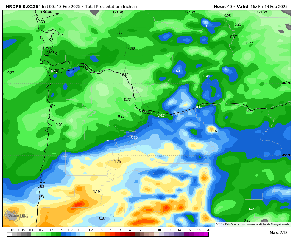
So I’m quite confident we have a snow and ice storm on the way, and I’m confident we will be more than cold enough for it to stick and accumulate on all surfaces. What is still up in the air is how much of precipitation falls all together, and how much falls as snow versus freezing rain. Check out how much precip this particular model has falling through Friday 8am.

That could be a whole lot of snow, or a scary amount of freezing rain, or a mixture of both, but then we have other weather models showing not quite as much precip. This next image below also is forecasting total precip, but it cuts the total literally in half. Sure it still gives Salem a hefty total good for 5 to 7 inches of snow, but that’s only half of what that first image advertised.

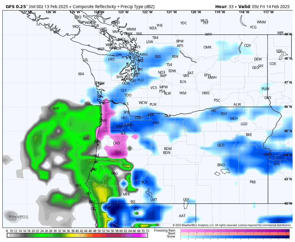
This next image shows that second batch of moisture directly over the Willamette Valley Thursday night into early Friday morning. The “SLE” is the Salem Airport. You can see how we are right on the edge of the freezing rain and sleet (pink coloring) and the heavy snow (blue coloring).

The important message is that we have a snow and ice storm on hand. How much do we get and is it more ice or more snow is a question we just can’t know this time around until it happens. Be prepared for icy roads, snowy conditions, and possible power outages. Truth is that around here it only takes an inch or two of snow to mess things up on the road anyway, so what’s an extra half foot between friends right? 🙂

Stay safe and enjoy the snow and ice!

Chilly dry weather

We are now entering into what will be a long stretch of dry weather. It may not feel dry with the cold damp fog hanging over our heads, but no additional rain is expected between now and at least next Wednesday (December 4th). Excellent news for people traveling by road! Our dry spell will be marked with fog that lasts for long periods of the day, or in some cases the entire day, occasional sunbreaks, and chilly temperatures.

Expect widespread frost possible each morning over these next several days with many of us seeing our first hard freeze of the year at some point this week. These strong ridge setups in the dead of winter are tricky because if the fog holds then temperatures can also hold steady throughout the day, but if the airmass manages to dry out a little then we could see a wider rang of temperatures.

For now I’m going with lows of 28 to 33 degrees – again depending on the extent of fog, and highs in the low 40s. Today will actually probably be our “mildest” day of the week as we are just entering into this inversion pattern. Our temperature as of 10:45AM is already a “balmy” 43°.

Remember, in these inversion setups both the coast and the Cascades are often times clear and sunny. Not warm, but escaping the fog can be nice. Here’s a snapshot of Newport Bay courtesy of Koin News and the Oregon Coast Aquarium.

Next we have a beautiful sunny picture from Hoodoo earlier this morning. Brilliant sunshine up above the inversion, and with 34 inches of snow at their base they are all set to open this Friday per their website. A great start to the year!!

God created a pretty incredible world, and I hope we can both take care of it and enjoy it. Stay safe, have fun, enjoy the people around you, and happy Thanksgiving!!