Weird weather

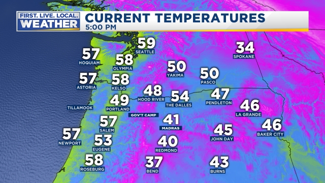
It was cool and cloudy today with temps struggling to get much above 50 degrees here in the valley.  Meanwhile it was more like a late summer day east of the Cascades with temps in the low 70s in a few spots!  This temperature map tells the story pretty well.

2pm temps 11.9.19

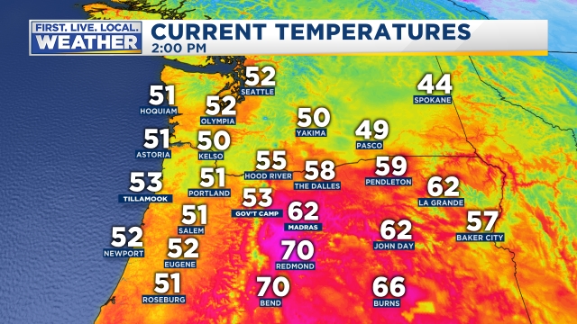
And in case you needed more proof of the warm weather over there, check out these web cam pics from earlier today.

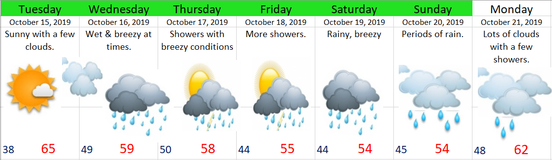
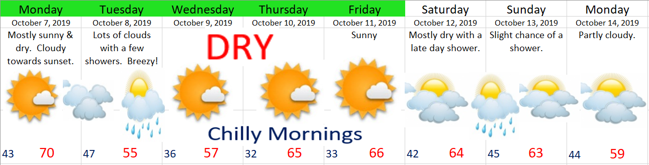
After a very wet September, we have been stuck in an unusually dry pattern, in fact Salem has had less than half an inch of rain over the past 20 days.  Very dry for this time of year.  Looking ahead we slowly return to a more typical wet pattern over the next 7 days.

11.9.19

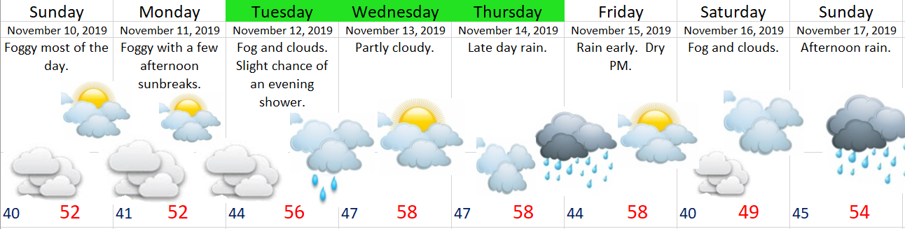
Notice I don’t have very many days highlighted green which means I’m not as confident about this forecast.  The biggest issue is the fog.  I see The Weather Channel and a number of weather apps are calling for highs Sunday and Monday in the low 60s.  I’m more than willing to be wrong on this one if it means we see temps in the 60s with sunshine, but I’m not holding my breath, and experience tells me the fog more often than not wins out this time of year…

The rest of the week will be damp with a few weak storms bringing light rain to the area.  A sorta “meh” type of weather pattern.


In other news October was chilly, especially when compared to normal October weather.  Salem ended the month 3.58°F below normal.

Temperature

Warmest high temp was 71°  October 7th  

Coldest high temp was 50°  October 29th  

Warmest low temp was 52°  October 21st

Coldest low temp was 24°  October 31st


7 days with lows at or below freezing.


5 days above normal.

4 day right at normal.

22 days below normal.


Precipitation

Precipitation fell 11 days.

The wettest day was October 18th with .68” of rain.


Summary

October averaged 3.58°F below normal.

We ended the month with 2.52” of precipitation which is a bit drier the normal October amount of 3.03”.

Winter is here

Winter arrived early this year.  Salem’s low temp Monday morning was 29°F.  That’s 12 degrees colder than normal.  Brrrrrrrrrrr!!!!!!!!!!!!!!!  Morning temps over the next 2 days are expected to be even chillier down to 25 – 27°.


Extended Forecast

forecast image 7

Highlights

No sign of any rain or any warmer than normal weather in the foreseeable future….

Wed & Thu:  Highs 50 – 54.  Lows 25 – 27.  Sunny.

Fri – Mon:  Highs upper 50s to around 60.  Lows 30 – 33.  Sunny.

Next Tuesday & Wednesday:  Still mostly sunny.

Stay warm out there!!!

Wet AM commute then dry…

Tuesday morning’s commute looks rainy, but come lunchtime the rain will already be over with as we quickly enter into a dry pattern with mostly sunny days the rest of the week.

On Thursday and Friday our high temps will be close to 70°, so a nice and dry late October week is in store.  Enjoy it while it lasts as this week will almost certainly be our last shot at 70 degree weather until March.  Sorry warm weather fans, but it’s just that time of year, and winter is coming……..


Enjoy and be safe!!

Wet week ahead

Monday was sure nice, at least weather wise, and Tuesday should be equally nice with sunshine most of the day.  Enjoy it while it lasts because we will be kicking off several wet days starting this Wednesday.

10.14.19

Highlights

Wednesday:  Rainy at times with breezy conditions.  I imagine winds could gust around 30mph which is fairly typical for a mid October storm.  Nothing to wild, but enough to blow a lot of leaves around.

Thu – Fri:  Showery with more gusty winds at times.  Some showers will be quite heavy, so keep those drains unclogged if you don’t want ponds in your street.

Sat – Sun:  Cool and wet.

Monday:  Slightly warmer, lots of clouds, and a few showers.


2 Dry days

A super quick post this morning before heading out for the day.

Highlights

Today and tomorrow:  The only dry days of the week.  Highs should top out between 63 and 66 degrees.

Wed – Sun:  Rainy.  I’ll have more details concerning the rest of the week’s forecast in a post later tonight just in case “rainy” isn’t detailed enough for you 😉

Enjoy the sunny weather and have a great Monday!!

A crisp October week

Did you enjoy the weather today?  If so then I have some good news for you as most of this coming week will be a near repeat of today’s weather.

10.6.19

Details

Monday:  Sunny with clouds rolling in around dinner time.

Tuesday:  Looks to be the only wet day this week, and honestly it won’t be all that wet.  Lots of clouds, but only a tenth of an inch of rain or so.

Wednesday – Friday:  Cold mornings with lows close to freezing, but sunny and mild afternoons with temps getting up into the mid 60s Thursday and Friday.  Very nice October weather if yo ask me 🙂

Saturday & Sunday:  Partly to mostly cloudy, dry most of the time with a chance for a couple of showers Saturday night through early Sunday morning.

Next Monday:  Partly cloudy with highs close to 60°.


Showers likely this evening

We have a batch of heavy showers moving south towards the Salem area right now.  These showers have produced heavy rain, hail, and even some lightning & thunder in the Portland area.  These showers are also cooling the air mass down quite a bit.  Look how cool Portland is compared to Salem as of 5PM.

5pm temps.jpg

Tomorrow and Monday will be unusually cold for this time of year with lows in the mid to upper 30s and highs struggling to reach 60 degrees if with sunny skies.

Enjoy the showers, and enjoy your Saturday evening!!