Storm update

It’s been a windy day out there.  We had some light rain through the morning, but the afternoon so far has remained dry right here in Salem.

It’s not so dry just to our northwest.  Check out this radar image showing a very sharp cutoff from the heavy rain and the dry weather we have here.

radar

Tonight and through much of the day tomorrow this band of rain will slide south over us before turning to showers Saturday afternoon.

Expect a few showers on Sunday, and at this point it’s looking like Christmas week will be mostly dry & cool with a good amount of sunshine.


Rainy weather update

Rain has fallen on and off all day today and winds have been blowing pretty good out of the south with gusts 25 – 30mph.

One big update to our forecast is that the heaviest rain will stay just to our north tomorrow during the daytime hours.  Expect light rain times with gusty winds continuing.  It will actually feel quite mild with temps up into the mid to upper 50s.

Friday night and Saturday look to be very rainy.

That’s all for now.

Enjoy the rain….

Lots of rain coming our way


2018-03-24 23.59.05

Yeah, not a whole lot in the way of sun over the next 4 days at all, but that’s wintertime for you here in western Oregon.

Rain is on the way and it looks like my previous forecast is still very much on track (miracles do happen I guess lol….).

Here’s a day by day breakdown of what to expect.

Wed:  Lots of clouds with a few sprinkles/light showers later in the day.  Nothing too bad at all with more dry time than wet.

Thu:  Periods of rain with windy conditions.  Wind gusts 25 to 35mph. A little over half an inch of rain expected.

Fri:  Looks to be the wettest day, specifically later in the day as steady moderate to heavy rain slowly moves across the area from the northwest.  Winds gusting 20 to 35mph.  1 – 2 inches of rain.

Sat:  Rainy much of the day with another inch or more by the day’s end.  Winds will be much calmer with gusts no more than 15mph.

Sun:  A few left over showers with some PM sunbreaks possible.


The Cascades

10 – 15″ of snow now through Sunday above about 4700′.

The two clearest times to travel the Cascade passes will be Friday and Sunday afternoon.

Have a great Wednesday!!!!

Rainy week ahead

We have some extremely wet weather coming up for the second half of the week.  I have plenty of details for you all below.

Extended Forecast

12.15.19

Details

Mon & Tue:  Foggy, cool, and grey.  The calm before the storm.

Wed:  Increasing clouds with showers.

Thu – Sat:  Extremely wet with extended periods of rain (fairly heavy at times) leading to totals of 2 – 4 inches for the mid Valley.  Localized flooding seems like a real possibility with so much rain in such a short timeframe.  Windy Thursday afternoon through Friday morning with gusts 25 to 35mph.

Sunday:  Showers around and cooler.


The Cascades

This will be a warmer storm system which means only some of the precip will fall as snow.  I’m currently forecasting 10 to 15 inches for the Oregon Cascades above 4500′ for the week.  Much larger amounts of snow for the Washington Cascades where the airmass will stay a little bit cooler.


The Coast Range and Coast

Tons of rain with 5 – 10 inches (or more) Wed – Sat.  Expect some landslides and mudslides along with some sharp rises in the rivers and streams in these regions.


Watch for icy roads

First off, we had the world’s shortest snowfall Saturday night.  For roughly 20 – 30 minutes it snowed in Salem.  Some nice big flakes, but the snow didn’t really stick, and within an hour it was nothing more than a cold rain.  Regardless it was still exciting if you had the chance to see it.

Moving on I see the chance for some icy roads Monday morning IF we clear up tonight.  We are currently at 37 degrees with cloudy skies.  If we clear up overnight temps will have no trouble dropping below freezing which means the wet pavement from the showers we had this evening would likely ice over.  Something to watch for as you head out the door in the morning.

I’ll likely have an update on the extended forecast in a day or two, but honestly it’s not looking exciting at all…  Mostly dry and cool weather will dominate this week with very little rainfall.

Have a great Monday!!!

Good morning!

A quick update this morning before heading into work.  We have a very powerful storm approaching the southern Oregon coast.  If you have travel plans almost anywhere in the state today or tonight, specifically south from Salem southward through northern California keep in mind the potential for weather delays and hazards is high.

You can see the storm approaching the coast right here:

https://rammb-slider.cira.colostate.edu/?sat=goes-17&z=2&im=12&ts=1&st=0&et=0&speed=130&motion=loop&map=1&lat=0&opacity%5B0%5D=1&hidden%5B0%5D=0&pause=0&slider=-1&hide_controls=0&mouse_draw=0&follow_feature=0&follow_hide=0&s=rammb-slider&sec=conus&p%5B0%5D=geocolor&x=6750&y=3186

Impacts here in Salem should be fairly minimal compared to the rest of the state with periods of rain and gusty north/northeast winds as the day goes on.

The Coast Range and Cascades will see a good deal of snow with this storm, but even valley locations south near Eugene have a shot at seeing a little bit of snow tonight with this storm.  I have a feeling Salem will be too far north to see any sticking snow.  You can keep track of regional temps and the progress of the cold air moving in behind the storm right here:

High temps Wed – Sat should be around 40 – 43 degrees, and lows will be in the 18 – 24 degree range.  Very chilly for the end of November.

I’m still watching the potential for some wintry precip Sunday.  Not a lot at this point, but keep in mind there could be some snow or freezing rain that day.

I will likely have another update tonight.  Remember to look for updates on Instagram as well.

Have a great Tuesday!!!


A wintry Thanksgiving week

Not too many posts from me lately as the weather has been very stable, or boring – depending on your point of view.  This will be changing in a big way as we head into Thanksgiving week.

Nov 23 forecast

Highlights

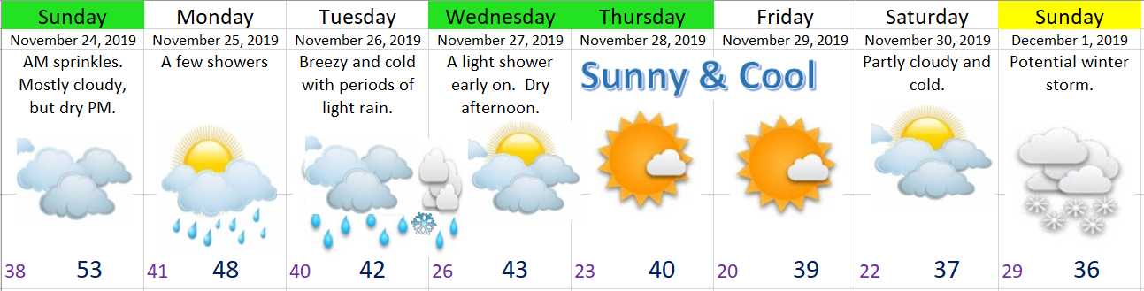
Perhaps the most important thing is that Wed – Sat will be dry right around here meaning good traveling weather for your fun thanksgiving plans.

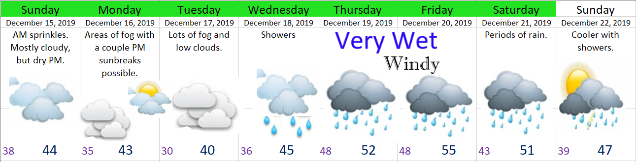
Sunday:  Lots of clouds around with sprinkles early on.  Nothing real exciting.

Monday:  Cloudy with a few showers.

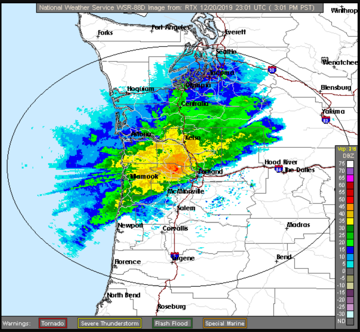
Tuesday:  Currently it looks like we stay breezy with periods of rain.  Cold air will be pushing in all day which means by Tuesday night snow levels will be down to around 1000′.

Wednesday:  A few sprinkles or flurries (nothing sticking at this point) possible early on before drying out.

Thu & Fri:  Very cold, sunny, and dry.

Saturday:  Cold with increasing clouds late in the day.

Sunday:  Watching the potential for some freezing rain and or snow here in the valley.

I will certainly have updates as the week goes on, especially for the storms Tuesday night and Sunday.


The Cascades

Mon – Wed look fairly snowy above 3000′ with 8 to 12 inches falling.  This is good news for skiers, but bad for travel plans.

Central Oregon

Snowy Tuesday night through Wednesday night.

Washington State

The storm on Tuesday is sliding by to our south, so if your adventures take you into Washington you should be mostly in the clear.