Sept 12th update

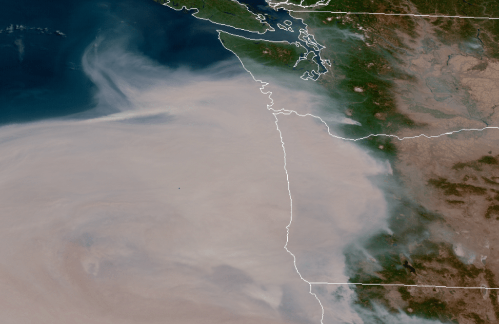
What was suppose to be an enjoyable week of late warm summer weather with highs in the 90s instead turned into a smokey and fiery hell leaving communities devastated along with a number of popular recreational sites, terrible air quality, and highs nearly twenty degrees cooler than what was originally forecasted due to thick smoke.

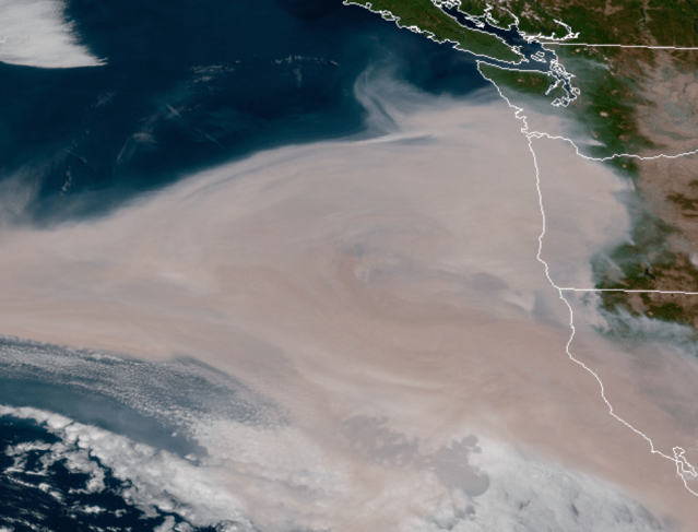
If you are looking for relief from the smoke it is still coming, very very slowly…… Our clearing out process will pick up a little on Sunday, at least up high. Down here in the valley we are essentially stuck in an inversion pattern still keeping the smokey air trapped near the surface until probably Tue when showers and rain finally move in. Of course with all the smoke and ash particles floating around in the sky this has the potential to be some of the grossest rain that has ever fallen here in western Oregon, so don’t go singing in the rain when it does arrive, at least not at first.

The rain will take its sweet time moving inland next week. The maps below show forecasted precipitation totals through Tuesday night and give a decent idea of what parts of the state will see rain first. In general places northwest of Portland, Salem, and down to Florence will receive decent rainfall Mon night and Tue while locations like Sweet home, Springfield, and much of the Santiam Canyon will sadly stay mostly dry with just a few sprinkles and isolated light showers until Thu. Of course if this storm comes onshore even a little bit further than expected then we would be looking at showers over those areas on Tuesday as well. Something we can be praying for.

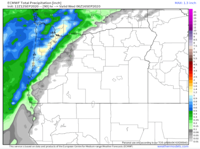
Those maps depict pretty clearly a sharp drop off in precip/rainfall as one moves southeast. Fortunately by Thu afternoon and Fri all locations west of the Cascades will be seeing rain as showers become widespread across the region. Showers continue on Saturday and possibly even through next Sunday.

What’s going on?

Another update for you all. As forecasted, easterly and northerly winds have died off which is good news in terms of slowing the spread of most of the fires burning in western Oregon; however, we have a few things going on which is making our “clearing out” process extremely slow. I’ll break it down for you.

1.) We are currently in a pattern very similar to the wintertime inversions we get when fog is trapped in the valley day after day. Similar, only this time it is extremely thick smoke and ash trapped at the surface.

2.) Light westerly/southwesterly winds will eventually begin “blowing,” if that’s what we want to call it, later this evening. Problem is these cooler breezes are expected to only be about 5 to 10mph tops meaning it will take a loooong time for us to clear out. For comparison the winds that drove the smoke into the valley the past three days were gusting around 20 to 30mph here in Salem, so this wind shift is helpful, but extremely weak.

3.) Yikes! Take a look at these satellite pics! Virtually all of the brown/grey you see on here is smoke, so who cares if we have an onshore breeze if there is smoke for hundreds of miles offshore. This is the result of nearly 3 days of easterly winds. I’ve never seen so much smoke so far offshore here. Just absolutely awful….

To help give some perspective on the affect this smoke is having on our weather, take a look at the area temps as of 2pm. Notice Salem sitting at 66 on a day when it should have been in the upper 90s. I’m not sure I’ve ever seen the Puget Sound 15 to 20 degrees warmer than us. Very unusual….

Insane weather for sure and praying that the worse is behind us. Of course, we won’t really clear out all the way until maybe Tue or Wed of next week after we finally get some decent rainfall. More on next week’s forecast later. For now take care and stay indoors as much as possible.

Fire weather update

I don’t have the latest numbers or maps on where the wildfires are burning or what locations are in need of evacuating. I’m learning that stuff as quickly as you all are and it is changing fast. What I can tell you is the winds should die down Thursday and even reverse direction a bit which will not only help clear some of this smoke and ash out (although it will take quite some time), but it will also help reduce and slow the spread of the fires.

The best news I can give you, besides the change in the winds, is that rain is finally expected to arrive Monday evening. In fact next Mon – Wed looks wet which should help put an end to any more significant fire threats. Of course Mon feels so far away right now, but it is better than not having any rain in sight. This map gives you an idea of how much rainfall we could be looking at next week. Lots of blue coloring over western Oregon indicating a solid half inch of rain or more. Good news for fighting the fires, and it sure as heck can’t come soon enough…

This satellite loop shows how the winds are driving thick smoke right into the valley.

I hope you all are staying safe and staying alert. There are what feels like an infinite number of sources to keep you up to date, so make sure you have one that is specifically for your local area to help minimize confusion.

Bad news

It’s hot out there, especially for September, and now we are about to add to the mix some strong winds which is really bad news for the wildfires currently burning here in Oregon. Winds pick up later this afternoon and will continue through Wednesday evening before finally dying down.

Here in Salem you can expect gusts around 25 to 35mph, maybe an occasional gust closer to 40. If you’re headed into the Cascades, the Coast Range, the gorge, or to the Portland area – so pretty much everywhere else in Oregon lol, then you could be looking at gusts over 50mph!

In case you missed the memo, this will be a warm wind and not the “cool you off” type of breeze we so often get. The next 7 days will be hot and well above average with a shot at going above 90 almost every single day this week and still no sign of rain. Enjoy the warm weather and pray for no new fires.

Hot September weather

I’ve taken a look at all the fancy charts and maps I enjoy looking at and I see a solid stretch of late summer heat headed our way. Aside from today, highs the rest of the week will be upper 80s to low 90s. Labor Day Weekend looks hot with highs in the low to mid 90s, and next week could be even hotter with highs in the 90s, and maybe even a couple of 100 degree days mixed in!!

So yeah, there you have it. Still no sign whatsoever of any significant rainfall or stormy weather. Pretty much nothing but sunshine and warmth for the next couple weeks. Stay cool, and enjoy this nice summer weather while it lasts!!!

Plenty of sunshine!

This week will pretty much be wall to wall sunshine for the mid Willamette Valley. Take a look at this beautiful late summer forecast!! 🙂

Looking further out through Labor Day weekend I see even more sunny and warm weather ahead with no sign whatsoever of any rainy/wet weather. This pattern is also typically very good for the coast with lots of sunshine over there too. A nice added bonus!

Enjoy and stay safe!

Quick change in the weather

In case any of you were worried about me or losing sleep, I’m here to inform you that your favorite weatherman is in fact still alive 😉 Hehe, yes, it’s been awhile, but (hopefully) like you I’ve also been attempting to enjoy our summer weather, and honestly there really has not been a whole lot to report on anyway.


We do have a brief downturn in our weather this Thu & Fri with mostly cloudy skies and even a chance for a few raindrops/light showers specifically Fri morning. Expect highs around 80 for tomorrow and highs only reaching the mid 70s Friday. Much cooler than the upper 80s and 90s we have seen the past several days. Don’t you worry though, regular warm summer weather will return by Saturday, and to be honest, this brief downturn is not necessarily all that bad…

Up until this past week Oregon has had a fairly quiet wildfire season. Of course below normal activity does not make for exciting news, so I figured I needed to take it upon myself to share that we are in fact having a below normal wildfire year – some good news for this 2020… 😉 Anyway, hopefully this cooler and slightly wetter weather will aid in controlling the wildfires that started this past week.

Saturday we warm back up into the lower 80s and next week looks warm with lots of 80s for highs and plenty of sunshine as we head into the 4th week of August.

Take care and stay safe!!!