December 26th

The Valley

A quick day after Christmas forecast for you all.  Nothing too exciting heading our way.  Just cool weather with rain at times and lots of clouds.  Basically I don’t see a whole lot of sunshine in the near future for us.

Dec 6


 The Cascades

The recent mountain snow, which I (so humbly) predicted has brought Hoodoo’s base up to about 40” which is awesome news!!  I see at least another 9 – 12 inches of new snow coming between now and Sunday night which will add to our now growing and somewhat respectable snowpack.

Snow levels look to be around 2000 – 2500’ today and tomorrow.   4500’ dropping down to 2000’ on Sunday.   

Snowy pass conditions today, Thursday, and again on Sunday.  Expect spots of ice and snow all the other days as the lack of sun will make it tough for the roads to really clear up.

 That’s all I got, so be safe and enjoy the rest of your week! 

Christmas time forecast

Christmas time is here which means this one man forecasting team hasn’t been posting quite as often, but I managed to squeeze some time in today for you all 😉    Before giving the forecast details for the next 7 days I thought I would give a fast recap to our “big storm” from this past Monday night.

The rain totals ended up being spot on with Salem recording 1.86 inches of rain Monday & Tuesday combined; although the majority of this fell Monday night while most of us were sleeping, so it may not have felt like much of a storm.  We also recorded a max wind guest of 48mph very early Tuesday morning which is the strongest we have seen all winter.  Overall not a huge storm, but definitely the “best” storm we have seen this year.


Looking ahead we don’t have any big storms or arctic blasts headed our way.  No chances for valley snow either, just some regular valley rain and mountain snow.

Dec 5

Details

Saturday evening through Tuesday morning will be the wettest period of the next 7 days. 

Notice a lot of yellow highlighting on the extended forecast.  There is a lot of uncertainty for next week, so keep an eye out for changes.  For now this is my best guess.

Big storm headed our way

Dec 4

Big storm details

Clouds continue to increase through the day with steady rain arriving during the later PM hours.  Expect moderate to heavy rain to fall all night long and through the early morning hours.  Strong gusty winds (likely the strongest we have seen this winter) will accompany this rainstorm with gusts 40 to 50mph!!  Rainfall will be very high during this short period of time.  Between now and Tuesday night most places in the Mid-Willamette Valley will see between 1 inch of rain for the “drier” locations and up to 3 inches of rain in the wettest of spots!!!  Keep an eye out for those usual flood prone locations/problem areas.

The rest of Tuesday afternoon will be showery and breezy.  Some showers will be quite heavy.


Rest of the week

Wednesday:  Patchy fog possible; otherwise partly cloudy and dry.

Thursday:  Dry start.  Partly cloudy giving way to late day rain.

Friday:  A few showers.

Saturday:  Showers.

Sunday:  Rainy.

Our driest times this week:  Wednesday and Thursday morning, and maybe late in the day on Friday.


Friday morning update

Real fast update this morning for my loyal followers.

First off, I must say it was a nice surprise yesterday with lots of sunshine.  I predicted a dry day, but I did not figure on so much sun.  A pleasant surprise indeed.


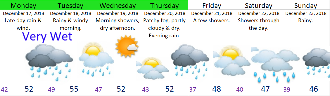
Today’s storm is slowly approaching and should be giving us all rain & a good dose of winds by dinner time, if not a little sooner.  Wind gusts will likely top out around 30 to 40mph this evening.  Highs today around 51°.

Saturday:  An isolated shower two before turning partly/mostly cloudy and dry.  Maybe some patchy fog.  Highs 48 – 50°.

Sunday:  A few showers.  Highs in the low 50s.

Monday:  Partly cloudy & mostly dry.  Slight chance for a light shower.  Chance for morning fog.  Highs close to 50°.

Tuesday:  Very wet and breezy.  Highs in the low 50s.

Wednesday & Thursday:  Rainy and breezy at times.  Highs 48 – 53°.

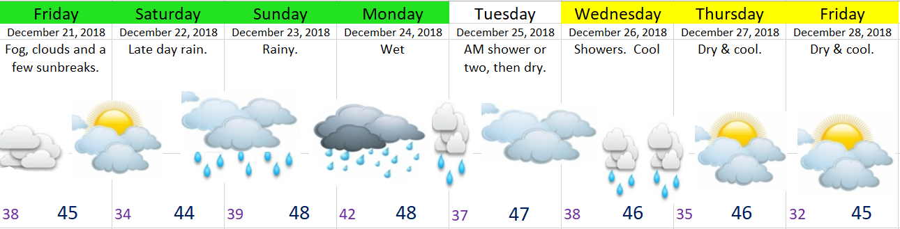
Friday (the 21st):  Mostly dry & cool.  Highs in the mid 40s.

Drippy Weather

Dec 3


Additional thoughts

Today’s storm as you might have already noticed has brought a fair amount of wind with it.  These breezy conditions will continue until tomorrow morning.  Rain will also pick up later today/tonight.

Another storm arrives Friday late in the day.

Sunday & Monday will be dominated by on and off periods of rain.

Tuesday looks very wet for now.

Our driest time will be Wednesday afternoon through Friday morning.  I suspect fog and clouds will dominate this dry time, so don’t expect very much in the way of sunshine. 

Maybe a few sunbreaks on Wednesday.

Final thought:  Thursday should stay dry, but showers will be lurking just to our north much of the day.  There’s a small chance a shower or two rolls down our way.  Just something to keep in mind if you require dry weather Thursday.


Cold rain ahead

You may be hearing rumors of possible freezing rain or ice, and I’m sure you were just hoping to find out what my thoughts were on the situation.  Luckily, I’ve got a brand new forecast just for you to help settle all those rumors.

Dec 2


Details

It’s cold out there right now and it’s been cold all week long.  No doubt about that.  Now we have clouds moving in.  The question is: will it get icy this weekend?  For the Salem area and most of the valley the answer is no.  Not in any way that should affect your travel plans.  It should be just “warm” enough here to keep us from getting any sort of freezing rain.  Instead we will be left with some very cold rain showers.  Lucky us!!! 😉

If you plan to travel through the Gorge it will be another story.  I expect some spots of ice and even a little bit of snow in the Gorge east of Multnomah Falls and more so out towards The Dalles.


The Cascades

Up in the mountains it looks like some light snow is on tap Saturday with steadier snow Sunday night & Monday.  Tuesday should be dry until evening when more snow will move in.

Snow totals by Thursday of next week should be around 10 – 16 inches for most of the ski resorts and mountain passes.