Cool & wet

jan 15

Details

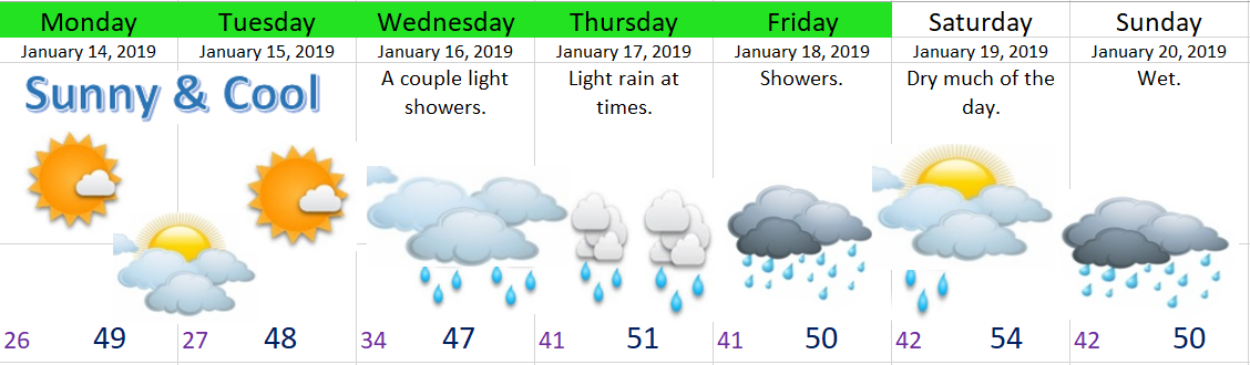
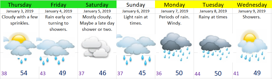
Wednesday is going to be a chilly day with showers at times and temps only in the upper 30s to low 40s.  Thursday will be wet with periods of rain.  Same goes for Friday.

Now if you recall in my last update I mentioned there was a chance Saturday could end up mostly dry.  After viewing the latest forecast maps it appears that chance is just about gone.  I guess that’s how it goes sometimes.  Anyway, it’s now looking quite wet Saturday and much of Sunday with a shower or two leftover on Monday.  Tuesday & Wednesday should be dry.


The Gorge

The east winds have been raging at the western end of the gorge and in the Portland metro area.  Those east winds continue through much of Thursday.  Light snow and some freezing rain is likely in the gorge along I-84 Wednesday evening and Thursday before “warming up” above freezing late in the day Thursday and more so by Friday morning.
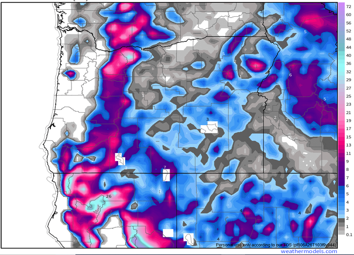

The Cascades

14 to 20 inches of new snow is on the way above 4000’ Wednesday night through Monday.  Up to 6 inches is possible as low as 2000’ by Monday morning.  This means snowy travel conditions for several days.

And there you have it.  Nothing real exciting for now, but as always stay tuned for the latest changes and updates!!!

Chilly Monday morning

It’s a chilly 28° here in Salem this morning, so make sure to bundle up before heading out!

Looking ahead I see two more totally dry days (counting today) before turning wetter for the remainder of the week.

jan 14

Saturday could end up being a fairly nice day with only a chance for a shower very early on and then again late in the evening leaving the majority of the day nice and dry.  Will have a better idea in my next update.

Have a great Monday!!!

Mild & Dry

Did you notice how mild it was yesterday?  Salem tied the record high for January 10th at 60°F.  Check out some of the other very mild high temps across the area.

highs 1.10

The relatively warm weather won’t continue with temperatures gradually cooling over the next 5 days.  By Tuesday daytime highs should be down in the mid-40s and lows into the 20s.  Regardless of how mild or cold it is, the one thing it will be is totally dry through at least Tuesday. 

This type of pattern also gives strong gusty winds through the Gorge.  Winds will easily reach 35 – 40mph out near Troutdale with occasional gusts above 50.


The next 7 days

jan 11

There’s a small chance for a couple of wimpy showers Wednesday.  Thursday into next weekend are looking fairly wet.

Up in the mountains it will be easy going for several days with no snow until Thursday.


*Minor correction:  Salem’s peak wind gust from the storm last week ended up being 54mph, not 51mph as I stated.  Small difference, but as always I want to make sure I’m delivering accurate information for my wonderful viewers.

Storm recap and the week ahead

Brief recap of Saturday night’s storm

Was a quick storm with the strongest winds arriving right on target at around 8:30pm and dying off sometime around 11:30pm.  The Salem airport recorded wind gust of 54mph, our strongest gust this winter.  Many locations in the mid valley saw 48 to 54mph gusts.

Of course I love it when my forecasts turn out well, and if you have been following me over the last year you should have no trouble thinking back to a time or two (or more) when I missed a forecast.  Today I’m happy to say this weekend was not one of those times 😉 🙂


Okay, enough bragging, and onto the forecast for this coming week.  Currently we have very cold showers streaming onshore which will continue much of the night.  The snow level is quite low at roughly 1500 feet (for sticking snow), and will lower slightly tonight down to 1000’ or so.  Check out how Santiam pass looked late this afternoon.


Very snowy up there and that will continue to be the case through Monday night.  All of this is good news for our snowpack.  I see Hoodoo is now reporting over 50” of snow for their base!

Back down here in the valley, I suspect a few roads could be icy early Monday morning IF we get some extra clearing tonight, so pay close attention to conditions before you stepping out to go tomorrow. 

This coming week looks wet.  No big washouts, just drippy regular Oregon rain.

Best chance for dry weather is Thursday afternoon through Friday night.

Next weekend is looking wet..

The calm before the storm

Highlights

  • A powerful and fast moving windstorm is on the way for tonight. I’m thinking gusts will briefly peak in the 45 to 60mph range which is strong enough to bring down trees and knock out power in places.  The winds will only last a few hours – a very quick hitting storm.  Timing of strongest winds should be roughly between 8pm to midnight.


  • Showers with this storm will be quite vigorous. Don’t be shocked if you see some lightning, hear some thunder, or get a hail shower.  This threat goes through Sunday evening.  Breezy/gusty winds could accompany these showers.


  • Snow levels are very high right now, but will fall rapidly tonight and through much of the day tomorrow. By Sunday morning snow could be falling as low as 1000’.  Again this shouldn’t affect Salem, but if you plan to go into the Coast Range or if you travel into the Cascades it won’t be long before you run into snow.


The previous forecast for Monday & Tuesday still applies with a few lingering showers Monday and periods of rain on Tuesday.

Wednesday & Thursday look wet with showers at times.

Friday:  A couple showers around.

Stormy weather

Highlights

Very active weather on tap for the entire Willamette Valley these next several days.

First things first, we have a pretty strong wind event headed our way Saturday evening into early Sunday morning.  Wind gusts should be in the 35 to 50mph range with chances that they go a little higher or lower depending on the exact track of the storm. Regardless it will be a rainy and windy night.  You can see the storm on the visible satellite right here.  Very impressive looking!!

Saturday night’s storm curling up and heading our way.

Sunday will be chilly & breezy with cold showers streaming onshore.  Could even see a hail shower or two.

Sunday night & Monday will be even chillier with a couple showers left over.  Snow levels will only be around 1000’ (possibly lower).  This means the Coast Range and Cascade foothills could see some snow (1 – 3”).  The snow potential does not affect the Salem area at this time…   

Here’s just one of the many snow maps I look at to help make my forecasts. This is total snowfall in inches ending Tuesday night.

A lot of purple and darker pinks in the Cascades indicating 6 to 12 inches of new snow up there with even more on the highest peaks.
Take away message:
  1. Cascade passes will be snowy Saturday night through Tuesday morning.
  2. Coast Range will be seeing snow at times Sunday – Tuesday AM.
  3. Foothills down to 1000′ will see an inch or two Sunday night/Monday morning.

Tuesday could be a bit interesting with a warm front pushing up from our southwest bringing plain old rain, but with cool air in place I could see the foothills and Coast Range communities start out with a brief snow or ice mix before changing to rain.  Something else to keep an eye on.

Wednesday & Thursday:  Lots of clouds with a few showers.

Friday:  Foggy & mostly cloudy.

Feel free to track the storm on satellite with link: http://rammb-slider.cira.colostate.edu/?sat=goes-17&z=1&im=14&ts=1&st=0&et=0&speed=50&motion=loop&map=1&lat=0&opacity%5B0%5D=1&hidden%5B0%5D=0&pause=20190104193219&slider=-1&hide_controls=0&mouse_draw=0&follow_feature=0&follow_hide=0&s=rammb-slider&sec=conus&p%5B0%5D=geocolor&x=4458.13330078125&y=4418.933349609375

More updates to follow, so stay tuned!!!!

First Forecast of 2019

I’ve taken some “time off” relaxing and enjoying time with friends and family and I hope you all had the same chance, but the new year is here and it’s time to get back into the swing of things.  Here’s a look at the next 7 days.

Jan 2

Highlights

Thursday will be a mostly cloudy day with just a few sprinkles.  More sprinkles and light rain the further northwest you go, so places like Amity, McMinnville, and the Portland area should all have a wetter day than those of us in the mid valley.

There is a greater than usual amount of uncertainty with the forecast for next week.  Currently it’s looking like Sunday – Tuesday will be quite wet with strong winds possible Monday evening and Tuesday.  Showers on Wednesday.