A quick throw back and a wild wintry weekend

Greetings!  It’s been quite some time since I last posted.  Being a first year teacher has been a wonderful experience, but it sure does take up a lot of time.  Anyway, before looking ahead to what should be an exciting weekend, I want to take a minute to review some highlights from January.  January 2020 has gone down as one of the warmest ones we have ever seen here in Salem.  The month ended 4.2 degrees above normal which is significant.  For a comparison on the other side of the scale, the cold February we had last year was 4.39 degrees below normal.

And how strange that for the 3rd year in a row we have seen a warmer than normal January only to have some sort of snow event in February or March.  2017 was the last time we had snow in January.  I’m currently working on a couple of graphs and I’m not finished with the data yet, but it appears as though February has been a snowier month than January during this past decade.  Interesting don’t you think???

Now onto something I think you will find far more interesting – we have a chance for snow now through Sunday night.  Details below:

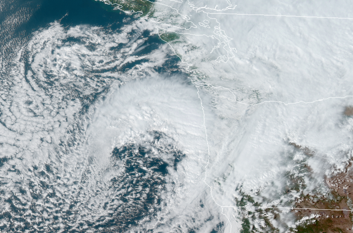
Tonight through Saturday morning:  Here’s what the satellite from around 4:40pm looked like.  You can see a nice comma shaped storm off the Oregon coast.  This sucker is going to send moisture over us tonight while pulling in cold air in through the Gorge.  If things come together just right there is no reason why anyone couldn’t wake up tomorrow morning to a coating of snow.  Lows around 32 degrees.

March 13.20

Saturday:  I expect snow showers (maybe some ice pellets and rain mixed in during the afternoon) on and off through the day.  Sunbreaks at times should help “warm” us up into the low 40s.

Saturday night – Sunday morning:  Similar to tonight’s weather only colder and slightly drier which means anyone could see a dusting of snow.

Forecast Summary

I like our odds for seeing a little bit of snow (better than anything we have seen this winter), but around here even when the odds are good it’s still not a slam dunk.  Finally, like the vast majority of our snow events this one is very marginal.  We could easily end up with nothing, or things could come together just right for a “surprise” 2 or 3 inches.  It’s the weekend, and there is no school next week which means I’ll be on top of this storm with updates should things change.

I’m personally hoping for snow as it would be a nice break from all this virus stuff going on, plus who doesn’t like a good snow event???

You can use this link to track the satellite:

https://rammb-slider.cira.colostate.edu/?sat=goes-17&z=3&im=12&ts=1&st=0&et=0&speed=80&motion=loop&map=1&lat=0&opacity%5B0%5D=1&hidden%5B0%5D=0&pause=0&slider=-1&hide_controls=0&mouse_draw=0&follow_feature=0&follow_hide=0&s=rammb-slider&sec=conus&p%5B0%5D=geocolor&x=6725&y=2674

Click on this image from Mark Nelson’s weather page to see the regional temps:

Have a fantastic evening!!!!!!!!!!!!!!!!


In for a treat!

I understand some of you may find the picture sorta gross with the glossy cake and my tongue sticking out, but it’s Throwback Thursday, and I figured I would add in an old pic of my siblings and I posing with some delicious treats 😉

I might be exaggerating calling it a treat, but if all goes according to plan Friday will be the mildest day we have had since November with highs 60 – 63°.  I hope you have a chance to enjoy the sunnier weather.  At the very least it will be nice to have a dry day.

Saturday will be vastly different.  Our high temp for the day will likely be around 8 or 9am, then a powerful cold front moves in with some heavy rain and gusty winds cooling us down as we go through the day.  Snow levels will drop to 1000′ by the time Saturday comes to a close.

Sunday will be a showery day with snow mixing in at times.  Anyone could see snow in the air, but sticking snow will almost certainly stay closer to 1000′ and higher.

The eastern Willamette valley has the best shot at seeing some sticking snow below 1000 feet Sunday night as the precip will be heavier out there while the colder air moves in.  It’s quite possible Silver Falls and other east valley school districts have a 2 hour delay Monday morning due to icy roads from this.

It’s also possible roads here in Salem have spots of ice Monday morning as well, so please drive carefully if that happens.

Next Tuesday looks chilly, but dry for now.  Highs in the mid 40s.


There you have it!!!  Happy Friday everyone!

Rainy, rainy, rainy

You don’t need a highly qualified weatherman like myself to inform you it’s been rainy. but I will anyway 😉 .  We are running well above average for January rainfall which is a good thing for the land and water supplies, but not so good for our outdoor activities.  In fact we have only had two completely dry days out of the entire month.

The look ahead.

Today:  Wet.

Thu:  Dry start with rain arriving during the afternoon.

Fri:  Am showers will give way to some mild partly cloudy afternoon weather.  Temps could easily make it into the mid 50s, which in the end of January is about as nice as it gets around here.

Sat:  Rain moves in during the morning.  Gusty winds and much cooler weather will accompany the rain.  Snow levels will drop through the day.

Sun:  Very chilly with low snow levels.  This will be a “fun” day with sunbreaks and a mix of rain and snow showers.  Anyone could see snow in the air; however, don’t expect the snow to stick unless you live closer to 500′.  Highs around 41°.

Icy roads are likely Sunday night through Monday morning, so travel with caution during these times.  Lows Sunday night into Mon AM will be around 31°.

Mon:  A few leftover snow or rain/snow mix showers.  Plenty of sunbreaks during the afternoon, but chilly.  Highs around 43°.

Have a great day!!

Slight chance for snow

We have mostly clear skies, a cold atmosphere, and moisture is expected to move in between 3 and 6am tomorrow morning.  This setup could give anyone a quick coating of snow.  I’m not expecting a lot (or any at all), but the possibility exists and I figured I would mention it.  Icy roads are also possible this evening.  I see that temps are already around 35°F and will likely be below freezing by 8pm.  After a disappointing lack of snow this week it would be nice to at least score a slushy dusting (maybe more) tomorrow morning.

By 11am we will likely be too warm for any more snow, so this will be a quick hitter if it even hits at all.

We will see what happens,

Happy Thursday night!!

The sad it’s not going to snow post

Yeah, unfortunately it looks really bad for snow chances Wednesday and Thursday.  There’s no beating around the bush on that one.  The forecast was looking so good several days ago and it has slowly and steadily just gone to pot for a lack of better words as I’m sure you have noticed both on my own forecast as well as on any apps or TV stations you pay attention to.

I guess that is how it goes living in western Oregon.  Ending on a positive note I keep telling myself that all these missed opportunities for snow will eventually “even out” in our favor someday.  I mean, one can hope.  🙂

The mountains are also receiving a ton of snow which is good news.  Hoodoo has about 65 inches at their base with lots more on the way.

Have a good Wednesday!

Tue AM update

Today could end up being a “fun” day in that we will likely see a little of everything including a few snow, ice pellet, and rain showers along with plenty of sunbreaks.  Highs in the upper 30s.

Here’s a link to the temp map for the region.  Updated at the top of every hour, this map gives a decent idea of how cold the airmass is around us.

Tonight we dry out and get cold.  How cold we get, the exact track of the next storm, and the amount of moisture available will determine how much snow we get (if any at all) Wednesday evening into Thursday.  I’ll try to do another update concerning that storm later tonight.

Peace out, and enjoy your Tuesday!!

Here we go

I’m sitting here this morning thinking how someday just maybe we will have an “easy” snow forecast for Salem, but for now it’s another extremely difficult forecast…

Highlights and details below.

1.13.20

Today:  We are setup for a nice cold rain today.  Snow will mix in at times, but I expect no accumulating snow below 500′ during the daylight hours today.

Tonight:  Rain/snow mix will change over to all snow; however, there will likely not be all that much moisture leftover which means a dusting to an inch seems most likely.

Tue:  A few snow showers throughout the day.  Could see anywhere from a dusting to 2 inches.  More of course the higher up in elevation you go.

Wed:  Cold, dry, and breezy.  I expect that sometime between 4 and 8pm snow will start falling.  Snow will arrive in the Coast Range as early as noon, but it will be slow to make it into the valley.  BIG CHANGE HERE.  Unless we get more snow than expected it is now looking like Wednesday will be a regular school/work day. ;/

Thu:  Snow will switch over to rain during the morning hours.  Could still be a snow day as this forecast is still up in the air, but not looking like the big snowstorm we all were hoping for.

Fri:  Chilly rain showers turning to a steady rain towards evening.

I’ll give an update as things change (most likely tonight).

Happy Monday!