Monday morning special

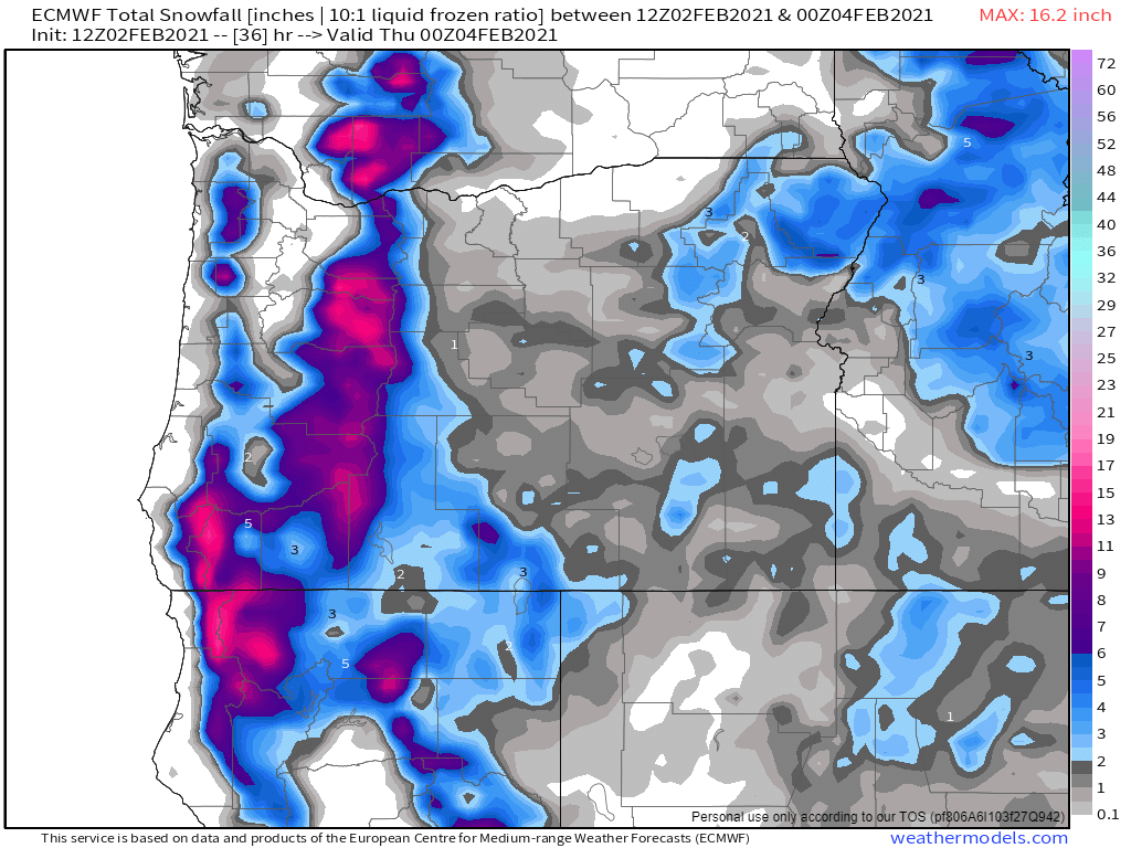
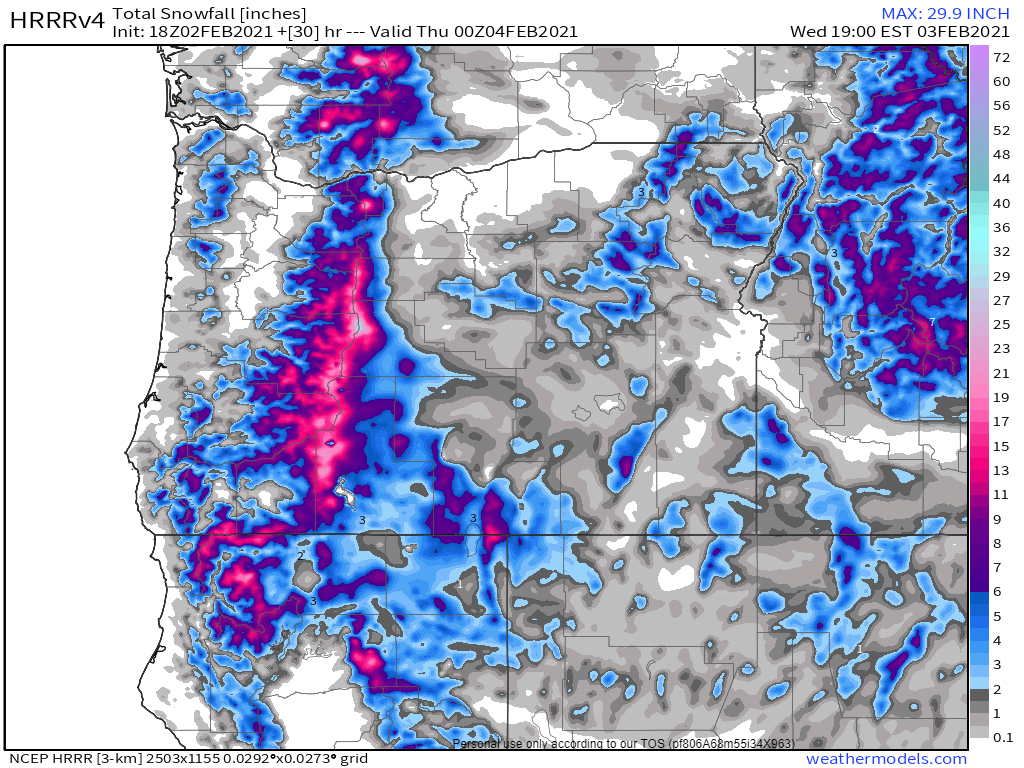
Our chances for snow have definitely increased since the last time I posted, but we still have a ways to go before I get too excited about us seeing a lot of snow. In my mind, these maps do a great job of illustrating why it’s so difficult to predict snow around here, specifically when it’s still several days out. Below is a slideshow of the 3 major weather models and their latest predictions for Thursday and Friday.

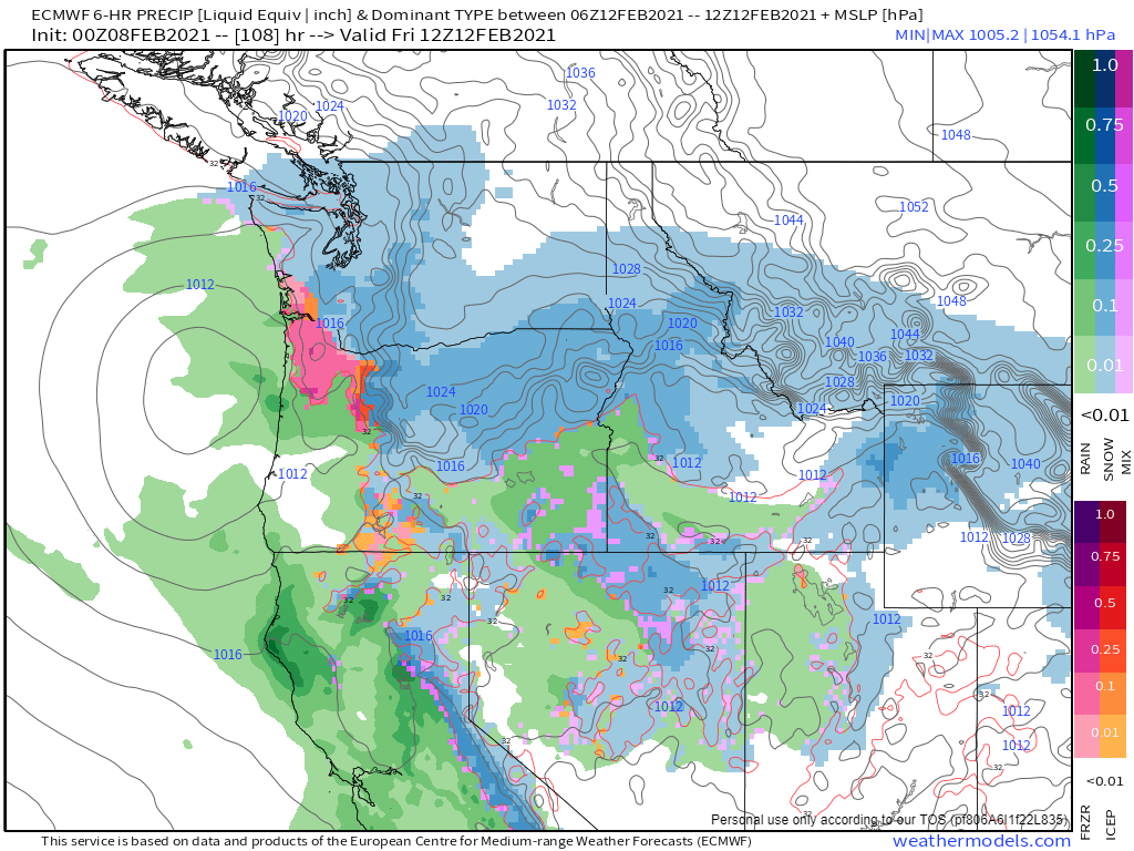
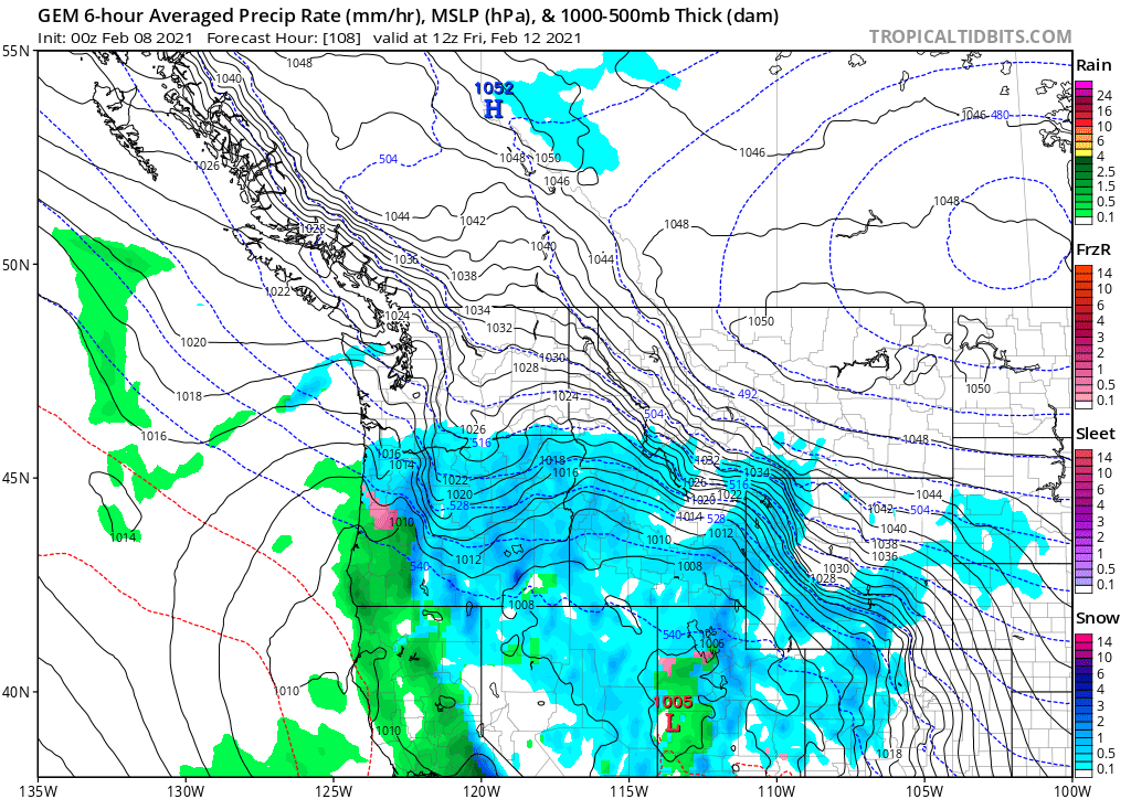
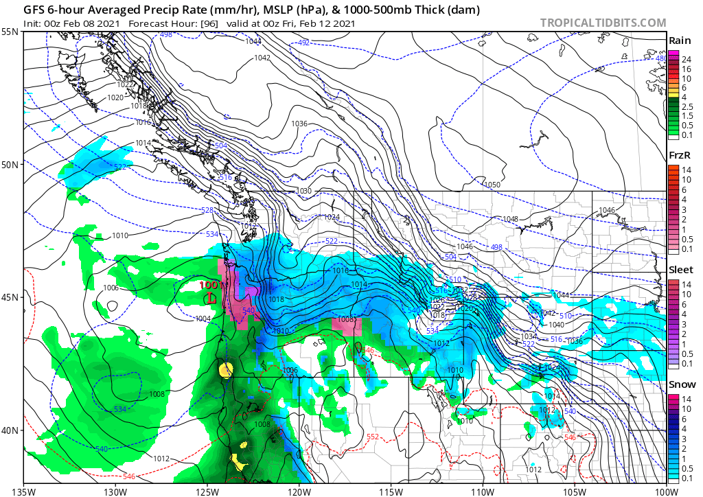
The first model shows Salem getting what would likely be mostly rain with a little bit of freezing rain possible, and maybe some snow mixed in if we are lucky. Overall though, this outcome would bring mainly rain to our area. Yeah, I know that’s what was said a few weeks ago when we saw that surprise snowstorm, and I imagine if this scenario played out there would still be a very slim chance of it being mostly snow, but I wouldn’t bet on it. The second model shows Salem receiving a good ol’ fashioned snowstorm with possibly several inches! The third and final model shows rain to freezing rain to eventually all snow. It also showed Salem getting snow next Saturday, Sunday, and the following week! A very snowy run indeed!

Like humans, none of these models are perfect and they each have their strong suits and their uh well not so strong suits. Knowing those and factoring those in is tough in a situation like this.

I know what you’re thinking, “make a dang forecast already! Haha. Here’s what I’m willing to say:

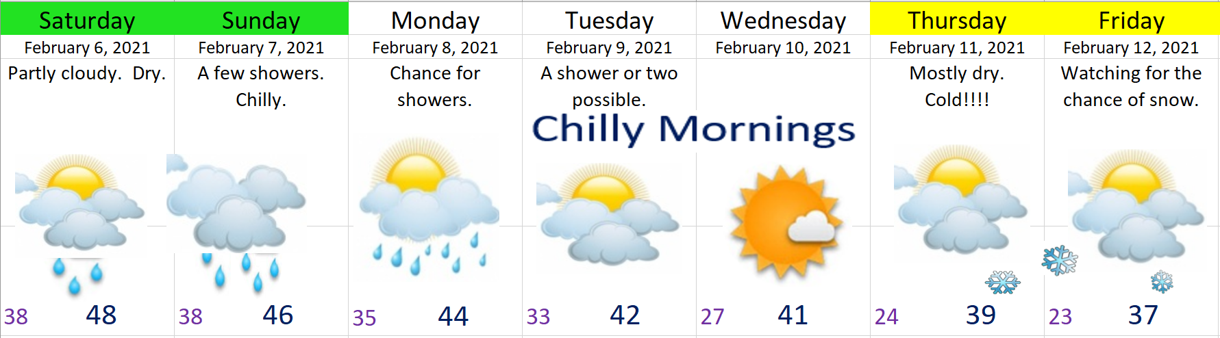
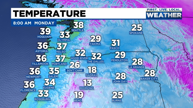
1.) This week will be the coldest week we have seen in at least 2 years. Lots of 20s and 30s at night and even some daytime highs not making it out of the 30s – maybe even colder if things work out just right, or wrong depending on your point of view. 😉

2.) Snow in Salem is fairly likely. Too much still up in the air to know if this will be a once in a decade type series of snowstorms (notice the plural there as some of the possible outcomes being predicted are showing several storms), will it be a run of the mill snowstorm, or will it be a quick hitter like what we saw a few weeks ago where it basically started melting as soon as the snow stopped falling. Or, there’s still a slim, and getting slimmer chance that we just see rain, but I’m hoping we can remove that possibility altogether real soon depending on what the new forecasts that come out later today look like. Bottom line is odds are high we see at least one more snow event of some sort whether it’s big or small and whether we see one or several is still unknown.

3.) Timing for this snow would be Thursday at the soonest, but more likely Friday or even Saturday. Many of the outcomes I’ve looked at have snow Friday, and again Saturday night or Sunday, and a surprising amount have even shown additional snow in the week to follow. I’m really hoping to have better idea tomorrow at least with the Thursday/Friday storm system.

4.) Monday through Wednesday will be fairly chilly, but no threat of snow on these days.

Look for updates all week long as there will be lots of twists and turns as we navigate what could shape up to be a very interesting week.

Take care!

Computer models, and much colder weather ahead!

I have to tell you there has been a whole lot of confusion on the weather models over the past week. By the way, when I say weather or computer models I’m not talking about fancy dressed up computers walking down a catwalk haha. I’m talking about a set of computers that forecast or model out potential weather outcomes two to four times a day (depending on the model). Getting back on track, I have noticed a shift in the models over the past couple of days showing some much colder, possibly very cold arctic air coming right down into Oregon next week. In my previous two updates you may recall me using an awful lot of yellow highlighting on the extended forecast indicating a high amount of uncertainty. Over the past week or so the forecasts have been going back and fourth between really cold weather and more mild/spring like weather. As of this afternoon there seems to be fairly solid agreement that a much colder airmass is headed for Oregon.

It’s too soon for very many details which is why I still have yellow highlighting for the last two days. The main message is much colder weather is on the way, and with this cold air will come an increased chance for valley snow. I sense many more updates in the coming week or two…. 😉

Here’s a few details and highlights for this coming week

1.) Saturday through Monday will feature a whole lot of clouds, but not a lot of precip. Basically a few showers each day with a couple peaks of sunshine here and there. We will also be getting progressively cooler each day with Saturday’s highs in the upper 40s. Sunday’s high temps will be in the mid 40s, and by Monday highs will drop down to the low to mid 40s.

2.) Tuesday through next weekend will no doubt be cold with lows possibly getting as cold as the upper teens. Brrrr!!! Regarding the chance for snow, there is still a lot up in the air right now. At this time I’m sticking with a mostly dry forecast, but don’t be surprised if a lot more snowflakes start showing up in the forecast. I’m watching Thursday through next weekend in particular as we could see a “classic” snowstorm setup with cold air in place and a storm system moving in to our south. In the past it is this setup which has typically produced our biggest snowstorms. Again, all possibilities for now, but it’s something I’m watching very closely!

THE CASCADES

Currently our snowpack is below normal for this time of year, and I don’t expect anything more than about 4 to 6 inches of new snow now through Monday which is not a whole lot. With that said, there’s still plenty of snow for skiing, snowboarding, snowshoeing, or whatever it is you do in the snow up there. 😉 As of this afternoon Hoodoo has a base of 67 inches which is still a decent amount of snow.

Of course, if a big storm does come in with the cold air late next week bringing snow to the valley, then I would imagine the mountains would also score some really big snow totals.

Happy Friday!!!!!

A look ahead

It’s February 2nd (Groundhog Day lol). I hope you’re doing well! I’ve got a fresh 7 day forecast for you and some quick thoughts on what’s coming up.

Highlights

1.) For the remainder of today we will see additional sunbreaks & showers with downpours, small hail, and the slight chance for a rumble of thunder.

2.) Wednesday morning could be interesting for a few of you as we have steady precipitation, a cooling airmass, and light winds. All three of those factors will work together to bring snow levels down quite low. Take a look at these two snowfall maps.

Hmmmmm and ugh lol… The last time these maps showed snow I ignored them lol and got burned. That’s not to say that these maps are not always right, but I’ll keep an eye on this still as it will be a close call for some of you. Basically these maps are both indicating snow falling down to very low levels briefly overnight tonight and into early Wednesday morning. Not a lot of snow at all, and not a very good chance, but after the “surprise” snow last Tuesday we should know that when things things work out just right snow is possible even if the chance is “not very good.”

I’m expecting just rain at this point; however, if it does snow, it will be brief and it should be no more than an inch or two for those of us in the valley. This setup favors locations south and east of Salem this go around. Eugene, Sweet Home, Lebanon are all have an increased chance of receiving snow.

3.) Either way, by mid morning we should have some nice sunbreaks and it will all be over with the exception of a few leftover rain showers during the afternoon hours.

4.) The rest of the week is pretty much what you see on the graphic. Nothing exciting for now, but extremely low confidence which is why I still have a lot of days colored in yellow. Every new forecast that has come out these past few days has spit something different out for this timeframe, and I mean everything from snow to rain to lots of sunshine lol which is making it extremely difficult to even guess what will happen this weekend and beyond. I’m hoping to have a better idea at some point tomorrow. For now, enjoy the sunbreaks and downpours.

Quick 7 day forecast

I hope you all are having a great weekend! Here’s a fresh 7 day forecast along with a few details and highlights for you all. 🙂

Highlights

1.) A very wet storm system is forecasted to come in Sunday & Monday. I’m forecasting around 1.5″ of rain to fall across the Mid Willamette Valley. No flooding concerns, other than some very minor and localized ponding here and there.

2.) Tuesday & Wednesday: Cool and showery, a few downpours possible with lots of Cascade snow. 8 – 14 inches of new snow during this time frame depending on elevation.

3.) I’ve highlighted Thursday & Friday yellow on the 7 day graphic indicating lower than normal confidence. Right now I’m leaning towards those days being wet, but look for a new update in a day or two with hopefully more details.

There you have it. I’m watching the long range for the potential of some colder air moving down into our region, so look for another update here soon concerning that potential!

Have a great rest of your weekend!!!!

More snow than I thought

Aww yes, good times….. Winter is here apparently. I’m a grown man, and I know when I’m wrong. I’m clearly wrong. The snow is falling hard out there and even though the temps are all above freezing, the snow is falling faster than it’s melting and now roads in in parts of Salem, specifically west Salem are turning white! These pics below are from west Salem (elevation around 230′).

The snow SHOULD still SLOWLY melt away tonight. Look for another update tonight, but yes. We are getting snow; although it’s still heavily favoring the western side of the valley, that part of my forecast is still holding true.

I expect poor driving conditions for the remainder of the day now for areas receiving snow, and watch for ice tonight!

Be safe and drive carefully!!

The No snow Monday night update :(

A real quick update tonight.

As mentioned in my previous forecast, temps really need to drop around 30° or colder tonight if we want it to snow tomorrow and that’s probably not going to happen. In this particular setup the west side of the Willamette Valley does better than the east side. There are a few reasons for that, but basically cool air blowing out of the gorge sorta pools up against the Coast Range allowing those communities to be colder than the rest of the valley. Yes, that is a real thing 🙂 😉

Take a look at this snow map showing snow in the Coast Range and for the locations and cities on the western edge of the valley. Salem is the big gold colored dot. It shows us getting some snow, but I’m not buying it at all. This same weather model has temperatures around 36 degrees during this same exact time which is why I’m not buying into snow here in Salem. Communities like Dallas, Amity, Newberg, and up towards Forest Grove and Banks could all score some snowfall with this storm. Precip should move in between 11AM and 2PM.

Here’s a forecasted radar image for tomorrow at around ***AM It clearly shows……

Bottom line is we will not see accumulating snow here in Salem tomorrow. Sorry, but we simply don’t have cold enough air in place. We will likely see snow in the air, maybe even a lot snow flying through the air, but it won’t be sticking. Perhaps if we are lucky, some brief accumulations of slush in spots, but nothing more than that.

If we wake up in the morning and temps are somehow in the 20s or even around 30, then I will be making drastic changes, but for now my thoughts are the same: no snow and no snow day here in Salem or Keizer tomorrow.

Progressing nicely.

Well, no major surprises yesterday. As forecasted, a very cold rain fell through most of the Sunday with snow mixing in above 500 – 1000 feet with plenty of snow falling in both the Cascades and the Coast Range. The airmass outside this morning is chilly. Check out area temps as of 8AM.

There are pretty clear signals that we will continue to stay under the influence of cool airmasses for at least the next 7 days. I see several more chances for snow coming up this week as well; although, at this time none of them are looking real solid. Here’s my latest thoughts.

The rest of today/tonight: We could see a brief snow shower, but do not expect accumulation. We have a better chance of seeing ice pellets or even hail accumulate today than we do with snow, and even that chance is minimal.

Tuesday: It really comes down to how cold we get tonight. If we can get down to 30° or colder, then I believe we have a decent shot at snow. The problem is we have no real source of cold air to draw from, and we don’t have arctic air in place either like we have had for past snowstorms. The precipitation is arriving during the daytime on Tuesday which is why it’s crucial (if you want snow) that we start the day off cold. I’m still leaning towards no accumulating snow except maybe briefly in the highest hills around town (west and south Salem). Could be a situation where we see lots of snow falling through the air, but not sticking here in town. I’ll have an update tonight and possibly again tomorrow morning as we get closer.

Wed & Thu: Low snow levels continue. Not expecting much (if anything) during this time either, but will keep an eye on things in case changes pop up.

Fri: Will likely end up being a similar to what we are seeing today, but with maybe a little more precip, and slightly cooler temps. Those two changes equal a better shot at seeing some light dustings of snow around town.

Sun: Another cold system comes in bringing low snow levels again… This is a long ways off, so not too concerned about it yet, but you get the idea – low snow levels are here to stay for awhile which means lots of updates and things to keep a close watch on.

Finally, it should go without saying, but both the Coast Range and the Cascades will be getting lots and lots of snow in this cool & damp pattern. Keep this in mind when traveling as almost every highway in the state outside of the Willamette Valley will be prone to snowfall most of this coming week.

Take care and happy Monday!!