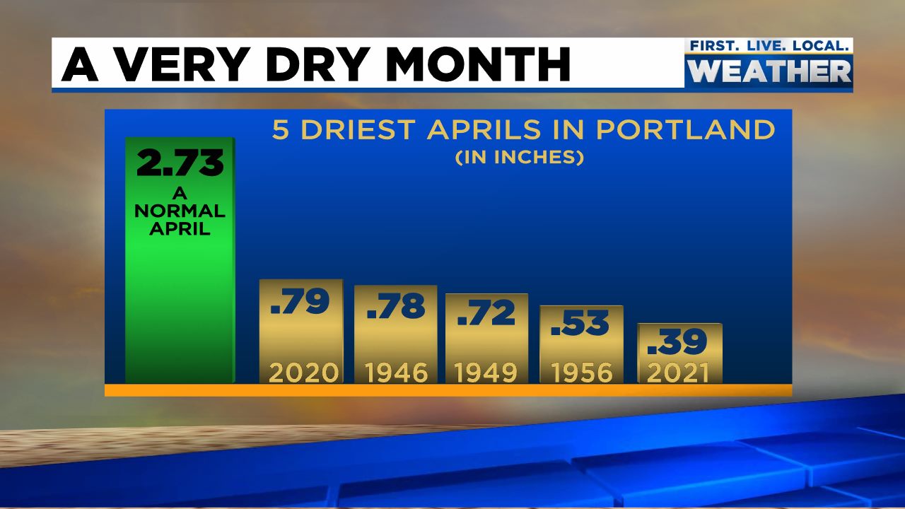
It was definitely a very unusual April around here as we started off chilly and dry with some record low temps set around the region with lows dipping into the upper 20s on two separate occasions. Then we flipped the switch to warm and dry (very warm in fact). Whether it was cold or warm, the entire month was extremely dry for April. Some last minute rain Friday night bumped us up to 1.27″ (45% of normal) for the month. I almost hate to say this, but we could sure use some good soaking rainstorms over the next couple of months. Check out this graphic from Fox 12 Oregon for Portland where they saw even less rainfall setting a new all time record for driest April up there.
April ended up warmer than normal coming in at 2.27° above average for the month – pretty impressive considering we had lows in the upper 20s a couple days during the first half of the month. Those 80 degree days the second half sure did help to warm us up! Now let’s take a look at what the next 7 days hold for us.
Forecast
Highlights
Wednesday’s going to be the nice summer like day of the week with highs in the low 80s and lots of sunshine.
Thursday should start off dry, but showers and maybe even a few thundershowers move in during the afternoon and evening hours.
Frequent showers on Friday.
Saturday through next Monday will be partly cloudy with a couple of showers each day.
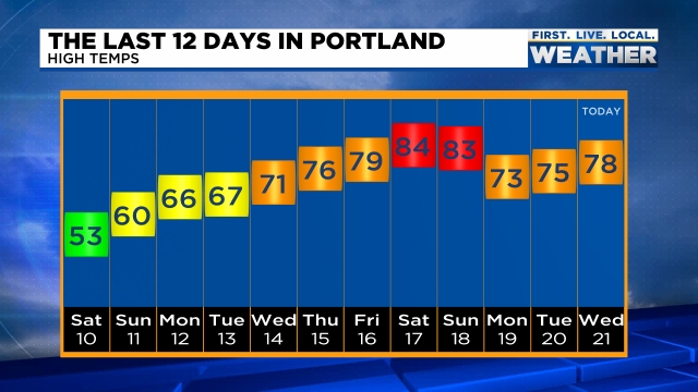
Interesting month so far. We started the month off with some very chilly – even record cold low temperatures, but wow how it has switched and turned around! We just had an incredible stretch of warm April weather with a new record high occurring this past Saturday with a high of 85° – a whopping 24 degrees above normal!!! This graphic from Mark Nelson with Fox 12 Oregon shows high temps in Portland and gives a good visual of our accent from very chilly weather earlier in the month to the record warmth we recently experienced.
The other record we are currently working on is a record dry April. Do you realize we have only picked up 5% of our typical rainfall for this point in the month? We are running way behind average! I have some good news though as rain looks to arrive this weekend. Okay, so rain on the weekend is not necessarily the best timing lol, but we need the rain; otherwise it’s going to be one heck of a summer.
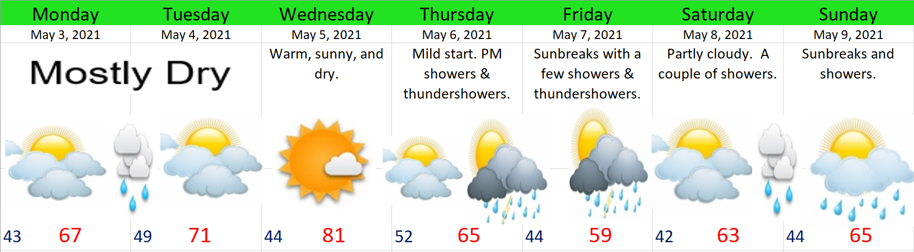
The next 7 days and forecast highlights
Basically rain continues on and off through much of next week, so hopefully we make up some of that deficit.
The wettest days will be Saturday and Sunday. We do have a shot at seeing a few thundershowers on Sunday. Monday should be mostly dry with showers late in the day, and as it stands now, Tuesday looks to be a fairly dry.
There you have it. Have a great rest of your work week and stay safe!
The sunshine outside is making it feel like a distant memory, but it doesn’t change the fact that we have seen some really chilly nighttime lows (for April) lately. Sunday morning Salem tied its record low of 29°! This nice graphic from The National Weather Service in Portland shows how record lows were widespread this morning across western Oregon.
Despite having a few mild afternoons (our average high this time of year is 60°), Salem is actually running1.8 degrees below normal for the month thanks to these very cold morning lows. Change is coming this week as much warmer weather moves in.
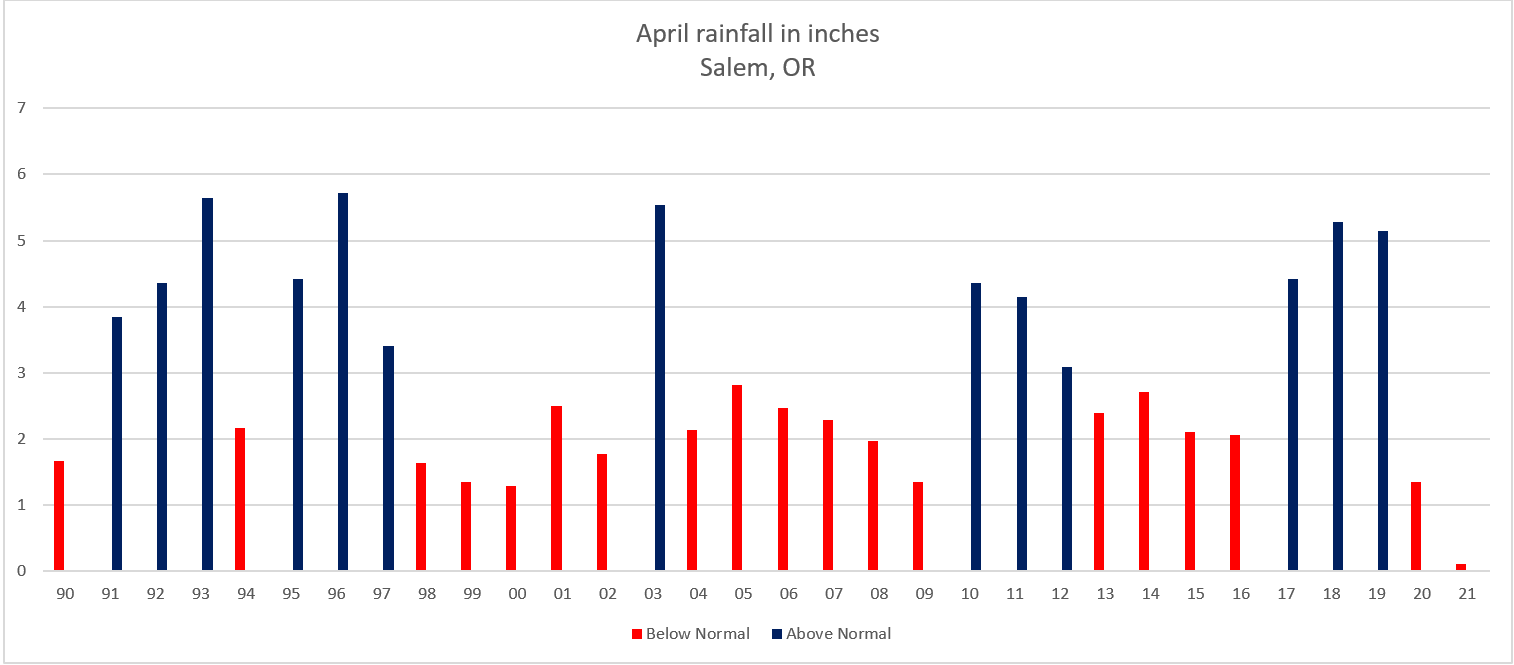
The other interesting thing this month has been the unusually dry weather. Very odd for April to be this dry. Do you realize that we’ve seen a mere 9% of our typical rainfall for this point in the month?!? It’s going to be a long summer if we don’t get a few good soakings later this spring. This graph shows the total rainfall for each April since 1990. Red years were below average while blue ended up with wetter than normal rain totals.
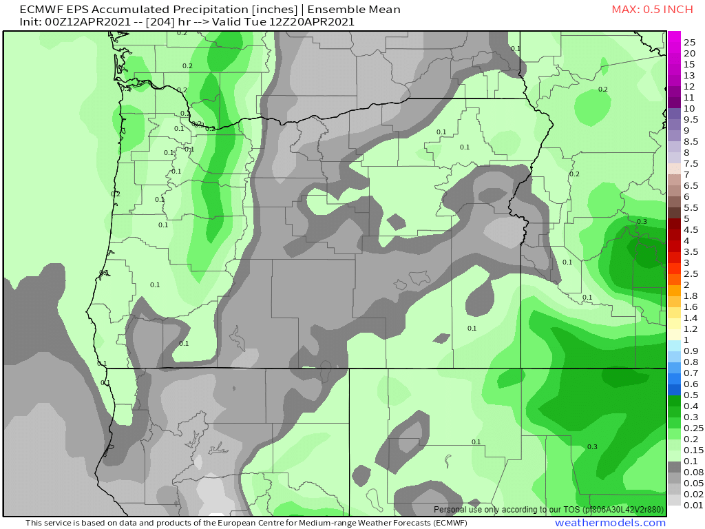
This next map shows estimated total rainfall in inches through next Monday. Basically nothing more than maybe a tenth of an inch falling on next Monday which means our extremely dry April is going to continue.
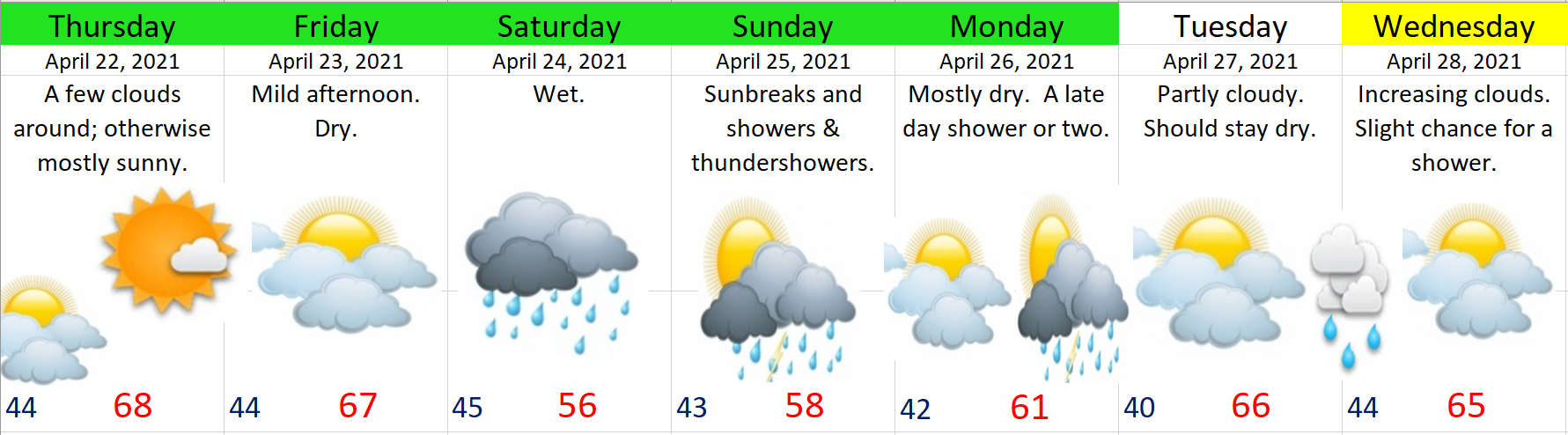
Might as well make the most of the dry weather though. For all we know May could be gloomy and wet. This whole week and coming weekend will be dry – no question about it with the next chance of rain being (as stated above) next Monday at the soonest. The warmest days will be Thursday – Sunday with highs in the 70s and maybe even low 80s Saturday and Sunday!!
There you have it. Enjoy the sunny and warm weather!
Winter is done and it’s time to see how my outlook faired when compared to reality. This is the full meal deal with lots of info, so make sure you’re sitting comfortably for this one lol 🙂 . If you’re looking for a forecast just know that we have a few showers coming in tonight through Thursday morning and then one more cool and showery day on Saturday before we dry out and warm up setting the stage for a very mild and sunny stretch of weather next week.
WINTER 2020/2021 REVIEW
Back in October it appeared as though we had a moderate La Nina on tap and I laid out several things that were more likely to occur during a La Nina winter based off of similar winters in the past. In case you wish to travel back in time to see what my thoughts and predictions were you can check out my 2020/2021 winter outlook here: https://bryanweatheralert.com/2020/09/28/winter-2020-2021-outlook/
1.) Wetter than normal: (OKAY). Nov and Dec were both slightly below normal, Jan was fairly wet, Feb came in a little above normal, but March finished out well below average. When all was said and done, Salem ended up right around average in the precip category. I stated in my winter outlook that a dry winter was very unlikely, and that part held true. This winter was definitely not a dry one, but to call it a wetter than normal winter would be a little bit of a stretch.
2.) Above normal mountain snow: (GOOD). We started the season off strong with above normal snowfall in November, but a warm and slightly drier than normal December brought the snowpack below normal by the time we rolled into January. Fortunately a few well timed storms in December kept enough snow on the ground through Christmas break to keep most of the ski areas operational – something we did not have the previous December.
The snowpack didn’t really increase much though until the end of January when we saw our brief snow event, and again with the colder weather during mid February. The cooler and wetter weather in February brought tons of snowfall to the mountains and pushed us above normal again. Occasional cool systems through the month of March maintained a very healthy snowpack as we headed into spring. With all things considered I call this forecast a hit with the snowpack being at or above normal for the majority of the winter.
3.) Flooding: This was not as much a forecast as it was more of a warning or heads up. I’m more than happy to have not had a big flood this year – something I think everyone could agree on… Flooding events are significantly more common during La Nina winters and that’s just a fact. We had no flooding on the Willamette River this year; however, we did have some localized flooding on several of our smaller rivers and streams in the region with a wet system in mid December, and then on a larger scale again in the first half of January when the valley saw 2 inches of rain in 24 hours with a storm on the 12th. Odds favor we see another La Nina next winter which means I would again sound the alarm for the potential for major flooding as this seems to be a trademark of La Nina winters around here.
4.) Snowfall. (GOOD). If you recall, I mentioned how the odds of seeing at least a little bit of snow increases with La Nina winters. Sure enough we saw some with our surprise snow event on January 26th which dumped a quick 1 to 4 inches of snow (depending on location) across Salem, and of course we also had our historic ice storm in February. So while the snow was short lived right here in Salem, we still picked up both snow and ice this year reinforcing the statement that La Nina winters tend to deliver at least some snow or ice. The official snowfall total I’m going with is 2.5″ and 1.25″ of freezing rain.
As far as wind goes, right here in Salem we had no major windstorms (widespread 50mph+ gusts). That said, the region did experience several minor to moderate wind events which brought scattered power outages to the Willamette Valley each time with the January 12th storm being the strongest windstorm
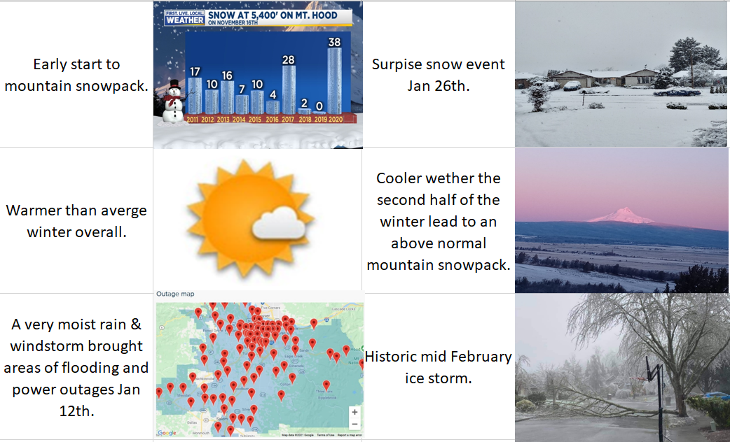
Next I have a graphic with the biggest highlights from this past winter.
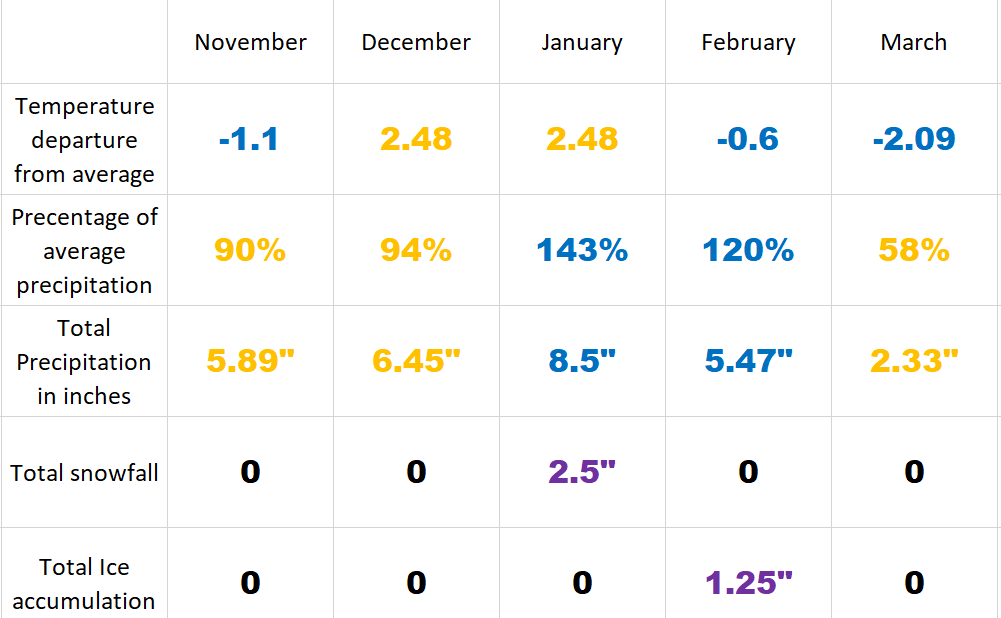
This second graphic shows how each month stacked up compared to average in both temperature and precipitation. I also included total rainfall per month, snowfall, and ice accumulation. Kind of a nice and neat way of seeing how each month faired.
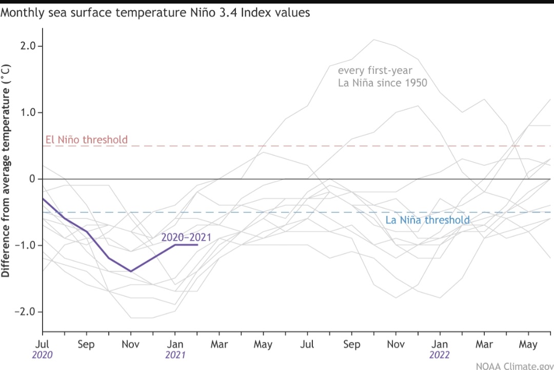
Having both December and January on the much warmer side of things is unusual for a La Nina. As far as the precip went, the wet January and February balanced out pretty well the three drier months leaving us right at average for the whole period. Looking ahead, early indications are La Nina will return in the fall. This is represented on the chart below which shows how most first year La Nina winters are usually followed by a second La Nina winter.
If next winter is indeed a La Nina, I would put my money on a more active year with a decent chance of a wetter than normal winter. I would also expect at least some valley snow again, a higher than usual chance for major flooding, an increased risk of a significant windstorm, and a healthy mountain snowpack. But let’s not get too excited or ahead of ourselves lol. I enjoy every season and the weather each one has to offer. I’m looking forward to some beautiful sunny spring weather – maybe a few thunderstorms mixed in (if we are lucky), and then hopefully a nice and warm, but wildfire free summer. 🙂
I have a very special guest post today coming from a friend who lives all the way in New York City! She and her friend have written up a nice forecast over there highlighting what one can expect should you find yourself in that unique part of the world. 😉 Our local Salem forecast is tagged along at the bottom. ENJOY!!!!
Forecast for New York City
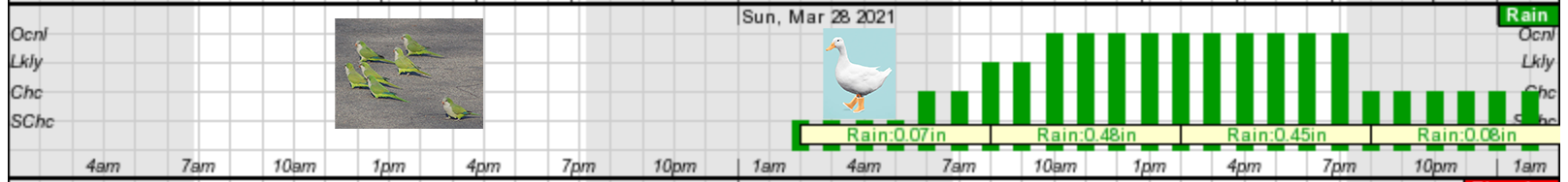
Saturday – a wonderful day, use best you can. Sunday…it’s for the ducks
Cold front will start rolling into NYC on Saturday around 4am and will calm the windy conditions seen on Friday. Clear skies with a temperature in the high fifties to low 60’s. Winds ranging from 12-25 MPH. Nice day that Saturday We recommend using it to get outside and catching a glimpse of the rare and exotic green parrots atop the Greenwood Cemetery Arch.
If you happen to forget your sunscreen on Saturday and end up getting a ring-tail lemur sunburn on your ankles, don’t fret, because Sunday’s weather will be keeping you inside. Early Sunday morning, starting at 2am, nice conditions will start to diminish, clouds will be low, winds will be light. Heavy rain will commence at 8am with winds hitting full tilt at 11am. Wind gusts will pick up to 40 MPH. As Sunday progresses, clouds will thicken like a split-pea soup (which apparently no establishment in NYC carries despite our repeated pleas) This will cause poor visibility and rain with the temperature in the low 50’s. Fog is not out of the question folks. Rainy conditions and visibility will improve during the evening, but wind will remain, so no skirts.
Monday the skies will be back to their old ways- a cool 55, partly cloudy, no winds. The perfect start to a week locked inside working. Looking ahead, Tuesday will be your last chance before rain picks up mid-week with the sun coming back to shine on all your beautiful, bountiful Easter eggs.
Salem Area Forecast
Looks like NYC has a similar weather forecast to us in that today is going to be a beautiful day with highs in mid 60s and lots of sunshine.
Sunday starts off nice; however, we also make a switch to weather fit only for ducks 😉 as things go downhill in the afternoon with a very potent cold front moving in. Winds will be strong at times gusting up to 35mph and rain will be quite heavy at times. If you have outdoor plans I would aim to have them done by 1 or 2PM on Sunday with rain moving in by 4PM at the latest.
Temps drop dramatically Sunday evening with this powerful cold front. Snow levels Monday morning will be down to 1000′. Lots of snow up in the Cascades. I’m thinking like 6 – 10 new inches with this storm. Very poor driving conditions up there Sunday night through Monday with gusty winds blowing that heavy snow around a bit. Back here in the valley we will be left with a few scattered showers on Monday before drying out for much of next week with highs returning to the 60s Tue – Thu or even next Friday.
Whether you are in the Big Apple or the Cherry City 😉 enjoy the nice sunny weather while it lasts and a special thanks to my friend and her roommate for writing up their gust post!
This week has gone pretty much as planned with showers today and continuing through tomorrow. Here’s a quick look at what you can expect now through Sunday.
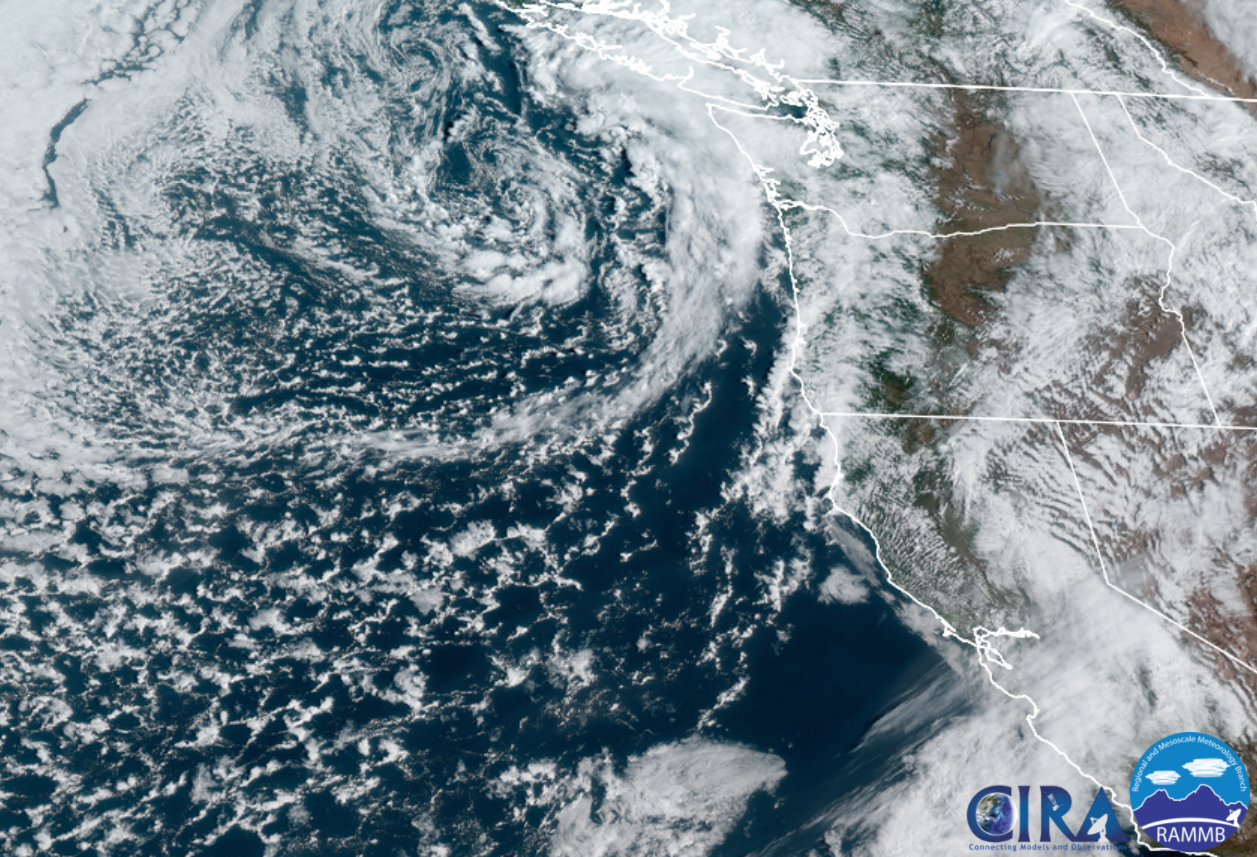
Today & Saturday will both be active days around here. Sunbreaks, lot of available moisture, and very cold air aloft (up in the atmosphere) will combine to give us a threat of a few thundershowers, downpours, and hail. Some of the showers could contain a lot of hail, so be careful if you are caught out on the road when one of these showers hits. This satellite pic from around 10:45AM shows a nice swirl of clouds and bands of heavy showers rotating towards Oregon. This will be our weather pattern through Saturday evening.
Snow levels are around 2000 – 2500′ with 5 to 10 inches of new snow falling in the Cascades through Saturday night. Expect snowy passes Monday, Wednesday and Thursday of Spring break.
Sunday will be the driest day this weekend with rain moving in sometime after roughly 3PM.
Spring Break
What everyone wants to know is which days are going to be nice and dry for outdoor activities, and which days are going to be wet. Fortunately, this guy right here has you covered! 😉
1.) Our mostly wet days will be Monday, Wednesday, and Thursday. These days will all have dry times mixed in between the showers, but overall expect these days to be wet.
2.) Now for the dry days! Tuesday, Friday, and next Saturday, & Sunday all look nice and dry!!! 🙂 🙂 So we should finally see a completely dry weekend around here!
There you have it. Stay safe, try to stay dry, and have fun out there!
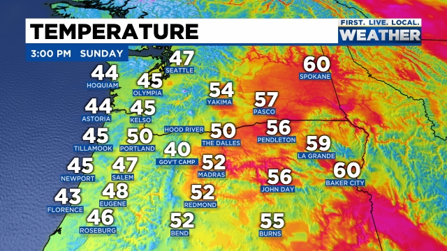
The forecast is still on track with a cold front moving through right now. Salem recorded a temp of 50° at 1PM and that will end up being our high for the day as colder air is already moving in from the northwest. You can see where temps stand as of 3PM with the coast being colder than central Oregon at the moment.
Snow levels drop down to 1000′ – maybe a little bit lower on the east side of the valley tonight as even colder air works its way down from the NW. Scenarios like this occasionally lead to “lower than expected” snow levels in east valley & foothill locations. Any lower than expected snowfall will be very short lived and minor, but don’t be shocked if you see a few slushy flakes mixed in tonight with the showers.
Monday should be a mostly dry day with just a few afternoon showers of rain, hail, and maybe some graupel. Graupel is really nothing more than a mixture of snow and ice pellets. Expect some of the showers to be rather heavy.
Nice dry and sunny weather looks like a lock for Tuesday and Wednesday before rain returns on Thursday through much of next weekend.
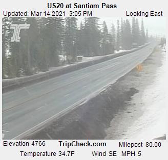
The Cascades
Passes turn snowy within the next hour and will stay fairly snowy through Monday morning with 3 to 6 inches of new snow. Santiam Pass has cooled 6 degrees within the last hour!
By Monday afternoon roads should be bare/wet as the increased energy from the March sun warms pavement up nicely this time of year.