We have had some incredibly hot weather this summer, and I plan on highlighting our extremely HOT weather in an end of summer post at a later date. For the moment I wish to highlight our thunderstorm potential here west of the Cascades.
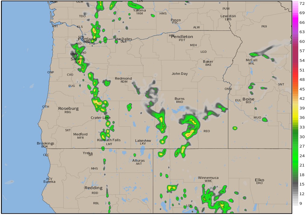
Basically now through Wednesday morning we have a chance for showers and thunderstorms with some of the storms having the potential to be quite strong. This goes for Salem, the entire Willamette Valley, and the coastal cities too. The storms will not be widespread which makes it extremely tough to forecast who will see action and who won’t. Check out these 3 separate forecast images:
This estimated radar image shows Salem getting hit by the tail end of a hefty shower, but missing out on any large storms.
Salem stays dry while strong thunderstorms roll along the Coast Range in this forecast.
Meanwhile this forecast nails Salem with a powerful thunderstorm right over the center of town.
The main idea is that scattered showers and thunderstorms will be moving through the region between now and Wednesday morning. Regardless of whether or not we see storms here in Salem, Wednesday will end up being fairly cool with highs topping out only around 80 degrees.
We stay in the 80s through the weekend 🙂 before the heat returns again later next week
The Cascades and areas east of the mountains will likely see storms too. Depending on rainfall with the storms they can be a blessing or a curse as lightning could fuel more wildfires over there.
Time to see what happens, but don’t be surprised if you get rained on or if you hear thunder.
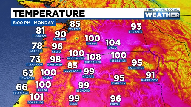
We are wrapping up day 2 of what will be one of the longer heatwaves we have seen in a few years. No, not the hottest (that title will likely remain with June 2021 for quite awhile), but it will be a very prolonged heatwave. Yesterday Salem reached a high of 94°, and as of 5PM today, we have reached 100°. Phew! Check out the toasty hot temperatures dominating the Pacific Northwest.
There is relief right along the coastline; otherwise, the rest of the northwest is baking (and will continue to bake) under the hot July sun. The sun below pretty much sums up the extended forecast. There are just a few highlights I wish to share with you before wrapping this post up.
1.) Nights will be unusually warm due to increasing humidity which will make it really tough to cool your house down with just open windows. Lows will bottom out 62 – 65° tonight through Monday morning of next week! Yes, it’s really going to be a long stretch of extremely hot weather!
2.) The length of the heat is my 2nd highlight. Highs anywhere from 96 to 102° are likely through Saturday with lower 90s continuing into early next week.
3.) Hang in there because much cooler weather should be arriving sometime around August 2nd or 3rd.
Stay cool, check up on people who may not have AC, and keep hydrated!!
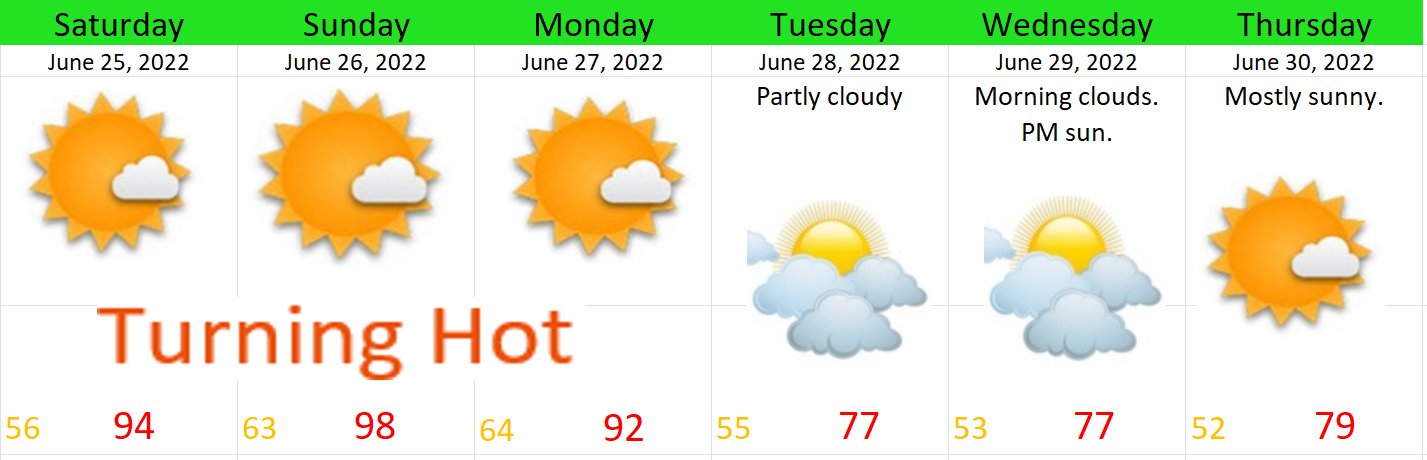
We were fortunate to have a completely dry Independence Day with a high temperature of 80 degrees. Today we have seen a few sprinkles and even a couple of showers. At any point between now and Wednesday night we could see a brief shower and maybe a rumble of thunder as these showers move across the region. The cooler air and showers are quite refreshing, but it is summer, and I know we generally root for sun this time of year, so the good news is we have a beautiful weekend coming up. Here’s our 7 day forecast.
Enjoy the cool & damp weather because it’s right back to regular summer weather by Friday.
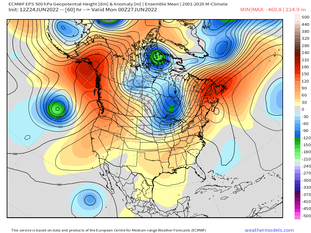
So far summer 2022 has started off much slower than last summer, but we are finally going to see things change (briefly) as a dome of hot air builds up towards us from the desert southwest. You can see the dome of heat is pretty much right over the Pacific Northwest by Sunday. The map below essentially shows temperature anomalies up around 18 thousand feet in the atmosphere.
Here’s what I’m expecting:
This will be a very typical heatwave with temps spiking close to 100° on Sunday before cooling back down on Tuesday. In fact, most of next week will stay close to average. No sign of any long term hot spells like we’ve seen far too often over the past several summers.
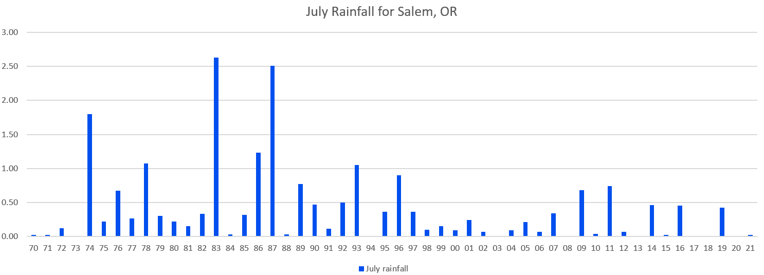
A question I’ve been getting is “will Oregon see a wet summer?” Based off of long range maps, my very best guess is yes, probabilities seem to favor a “wetter” summer. Problem is, this statement can be very misleading and here’s why. Take July for example, on average Salem only sees rainfall between 1 and 2 days each July which means 3 rainy days technically equals a wetter than normal July by that metric. However, if you do the math, this still leaves us with 28 days or 4 full weeks of totally dry weather for the month, so can we really just call 3 rainy days a “wet month?” My answer there is no. If you want to know what a truly wet month looks like then think back to April or last December lol. Hopefully my point is coming across here okay… To help illustrate this further, check out this chart showing total rainfall in Salem for July going back to 1970.
For the record, the average rainfall for July is just under half an inch. 1993 is the last time we saw more than an inch of rain in July. Goes to show just how reliably dry this month is for us. If we do manage to receive half an inch of rain this July, it will make it the wettest one in 11 years!! Similar story for August and the first half of September too. Our summers are reliably dry and that’s what I like about our climate. It’s so awesome having a 2 – 3 month period of warm mostly dry weather for getting outdoors.
Bottom line is, it doesn’t take much rainfall to make it a “wetter than normal summer” around here. Long range charts do show the potential for rain and showers sometime between July 4th and July 7th. Poor timing if it interferes with Independence Day celebrations, but we should quickly return to dry summer like weather afterwards as we head further into the month.
My best guess is this will not be one of those summers where we go nearly 2 months without any rain as we have seen many times in the past decade. I expect showers will pop up a few times through the next couple of months; however, just remember that should we see showers, the warm, sunny, and dry days will still far outnumber the “wet” days.
I will keep a close eye out for any rain chances, but unless we have more big heatwaves or a rare summertime rainstorm (or thunderstorm outbreak) on the horizon, I probably won’t be posting a whole lot as this is our quiet time of year – not to mention it’s the one time of year I get to recharge before heading back into the classroom. 😉 🙂
Despite all the rain being forecasted, and believe me there is a bit of it ahead, we also have a few dry times coming up also. I’ve highlighted those dry times for you as I know they have been few and far between lately.
First up we have Thursday evening. Much of Thursday will be a total washout with moderate to even heavy rain at times, but the rain will shut off quickly right around 4PM give or take an hour leaving us with a fairly nice Thursday evening.
Dry weather should last through Friday morning before more rain moves in.
Saturday will be mostly wet, so overall a “no go” for outdoor stuff that day, but Sunday is showing signs of being dry. I will keep a close eye on how things progress and should have an additional update before we enter the weekend. I will also be watching Monday and Tuesday for the chance of seeing dry weather on those two days as well. These would not be very warm days, but they have the potential to be drier with highs in the low to mid 60s.
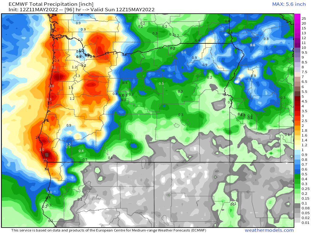
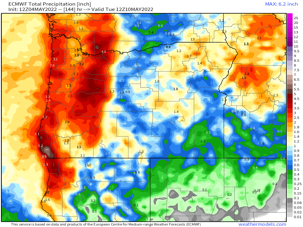
The map below illustrates well how much rain we are expecting through Saturday. Looks as though we are set for a solid 1 to 1.5 inches of rain for the mid Willamette Valley and even a bit of rain east of the Cascades again which is good news for their drought conditions.
That map looks like what we would see in fall or winter, not the middle of May. It’s been an extremely soggy April and May, and while it’s true a few dry days will pop up here and there, overall the Pacific Northwest is still locked in a very wet pattern for mid May with no sign of any real warm weather or long stretch of dry weather.
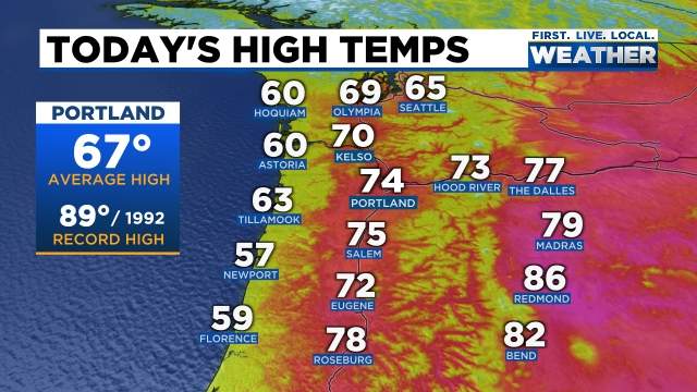
For us Star Wars fans today is a great day to celebrate the Star Wars franchise. Every year on this date I see a number of Star Wars themed shirts and hoodies, and today was no different. Today was also a wonderful day to be outside with highs reaching the mid 70s this afternoon. You can check out the very nice high temps from around the NW today with 60s extending out to the coast as well. I hope you took full advantage of the nice weather, because looming on the horizon is a washout.
Now take a look at the total rainfall expected through Monday night.
Widespread totals around 2 inches here in the Willamette Valley, and what is perhaps even better news are the inch plus totals east of the Cascades where they still could really use the additional precip.
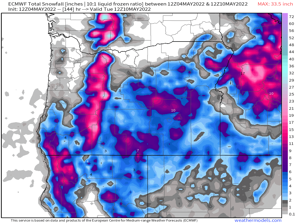
Next check out how much snow is expected as well.
The map above looks more like a winter time map than a early May map with snow levels Friday night through Tuesday running quite low for this time of year. I’m going with a solid 1 to 2 feet of new snow for the Cascades above about 4000′ with up to 10 inches down as low as 3000′. Really great news for delaying the start of any major wildfires.
I know this wet weather is going to start getting old, but it’s what we needed. This is a huge change in pace to the past few springs which have generally been very warm & dry, plus I can assure you that as long as we still have 4 or 5 feet of snow on the ground in the Cascades, our risk of having a big early season fire outbreak is next to none.
Salem’s Extended Forecast
Right here in Salem expect Thursday to be cloudy and wet – a real soaking for sure! Maybe some breezy conditions at times with highs in the upper 50s.
Friday will also be quite wet with periods of heavy showers, but with a slight chance of thunderstorms too – especially if we get lucky and see some sunbreaks that day.
Saturday & Sunday will be more of our typical sunbreak/shower type of days with a number of sunbreaks mixing in between downpours. Small hail, thunder, and lightning are definitely possible all weekend.
Next Monday will be a sunnier version of the weekend with showers slowly building through the course of the day after what should be a fairly sunny AM. Chilly though with lows dipping into the upper 30s possibly. The late afternoon and early evening hours on Monday feature the greatest threat for showers and storms.
I’m searching hard for our next 70 degree day and will alert you the moment I feel confident one is coming. This spring really is vastly different than what we experienced last year, and for the time being there seems to be no sign of things dramatically changing either…
Quick, but important update for you all this morning. Currently we have just plain old rain falling out there – nothing special, but once that clears out around 11AM to noon, things will turn more interesting.
Sunbreaks will destabilize the atmosphere later today allowing for heavy showers or thunderstorms to pop up. This is very similar to what we have seen several times over the past 10 days. Hail, maybe a funnel cloud, very heavy rain, and possibly very gusty winds are all possible with these storms this afternoon and evening. It could be a wild second half of the day…