Between moving into a new house, my brother’s wedding, and our crazy ice storm I realized I never published a recap of January. I had it written up all nice & neat and ready to go, but it never got published. So, I figured I might as well combine it with February for a special two for one deal hahaha!! If you’re looking for a forecast than hang tight. I’ll have a forecast out real soon as well. 🙂
January 2021
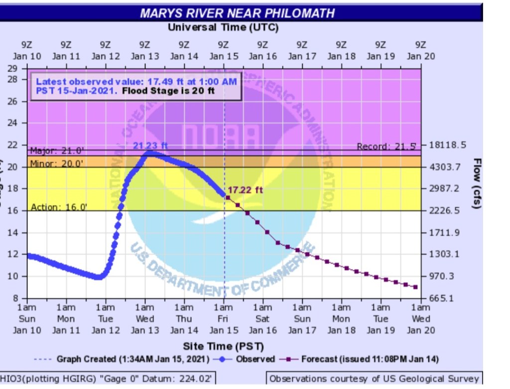
It may seem like distant memory, but the first 12 days of January were stormy, wet, and windy. Salem picked up 6.72″ during this time frame. The most significant storm arrived on the 12th bringing 1.93″ of rain, 45mph wind gusts to Salem, and localized flooding in both the Coast Range and along the coast itself as powerful waves crashed ashore. Flooding with this storm was particularly bad on the Mary’s River down near Corvallis where heavy rain stalled out for a longer period of time causing a sharp rise in that river.
The second highlight was the much warmer than normal temperatures which dominated the majority of the month. Salem had 18 days with highs in the 50s. Low temps reached or fell below freezing 9 days, but the coldest temp for the entire month was only 26°. Salem ended the month 2.48° above normal – a very mild January for sure! A brief cool spell near the end of the month offset some of the warm weather, but it also set the stage for the 3rd and final highlight of January 2021.
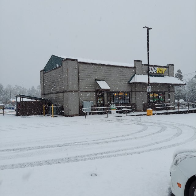
A surprise snowstorm hit Salem early in the afternoon on the 26th. If you live east or north of downtown then you might not call what took place a snowstorm, and for those parts of town it really wasn’t; however, for areas west and south of downtown what took place was about as legit of a snowstorm as we get around here. Heavy wet snow dumped during the afternoon hours of the 26th leaving behind 3 to 4 inches of snow in both south and west Salem. Snow quickly covered roadways making for treacherous driving conditions specifically in the hilly parts of Salem. Downtown had just shy of 2 inches while Keizer and areas east of Lancaster saw accumulations of an inch or so at most. Locations west of Salem and down towards Dallas & Corvallis picked up 3 to 5 inches of snow as well. It was a very localized event which favored the western Willamette Valley, but for some of these locations it was the biggest snowstorm since January 2017. The snow melted away quickly though as we returned to more mild January weather the very next day.
Summary
January 2021 was quite mild ending 2.48° above normal, and wetter than normal with 8.5″ of precipitation in total giving us 143% of our average precip for January. In the snow department we had an unofficial snow total of 2.5″. Quick reminder that snow totals are no longer kept track of at the Salem Airport making it difficult to obtain official snowfall totals for Salem.
February 2021
Officially no snow was recorded in Salem this month. With that said, February brought us our coldest high temp of the season 0f 30° on the 12th. A whopping 21° colder than normal for that day! This was the same airmass which also brought copious amounts of freezing rain.
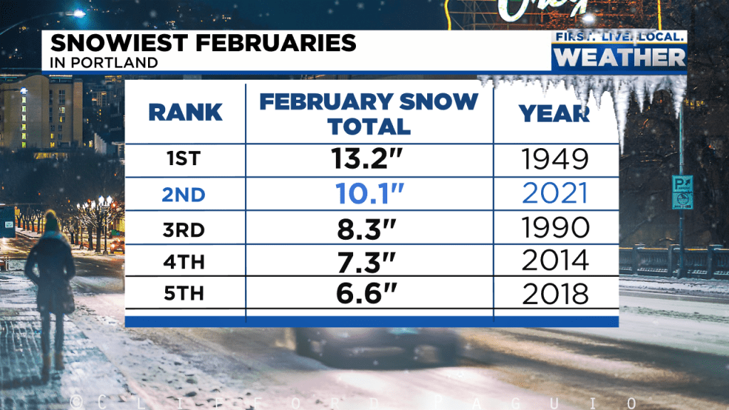
I’ve been making the case for awhile now that February has become our snowiest month of the winter. Sure there was no snow this February here in Salem, but the cold and freezing rain still helped to solidify this idea that February has become an increasingly cold and wintry month – much more so than in the past. Same story for Portland with the biggest difference being they actually saw snow (ten inches in fact) from the storm this past month. Looking at this graphic produced by Mark Nelson over at Fox 12 Oregon, I find it interesting how 3 of Portland’s snowiest Februaries ever recorded (records go back to 1938) have taken place during the past decade. If we were to expand this graphic a little more, February 2019 would be on there with 6.5″ of snow making that 4 of Portland’s snowiest Februaries occurring in the past ten years….
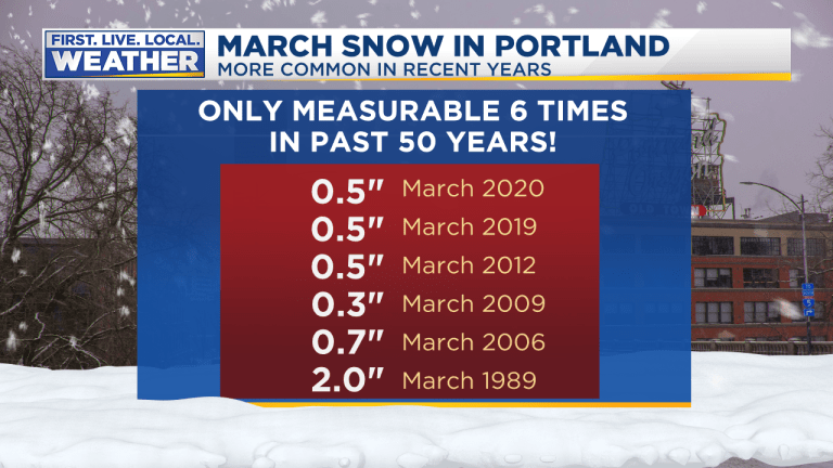
There definitely seems to be a trend for snowier and colder Februaries around here, and the same goes for March too. I have one more weather graphic from Fox 12 showing measurable March snowfall in Portland over the past 50 years. Again, seems like March has over performed in the snow department during this most recent decade.
It seems like winter is taking longer to get going in recent years with less snow in November and December, but once winter finally gets its act together it’s been slower to leave resulting in colder and snowier weather in February and March than compared to what we use to see. Curious to see if this is something long term or just a temporary trend….
Moving on lol, the only other highlight from around the region would be the big snow totals seen up in the Cascades during the second half of February. Hoodoo Ski Area closed out the month with around 103″ of snow at their base. No shortage of snow up there!
Summary
Other than our brief and intense blast of cold weather and freezing rain storm, the rest of the month was very tame. Salem had nearly 120% of our average February precipitation making for a slightly wetter than normal month. This is typical during a La Nina winter, so no big surprises there. As far as temperature goes, Salem had 7 days which reached or went below the freezing mark, and we ended the month 0.6° below normal. February 2021 goes into the books as slightly cooler and a bit wetter than normal.
We will see what March has in store for us, but I suspect above normal precipitation with lots of mountain snow as this would be typical of a La Nina winter and typical of what we have seen in recent years, but time will tell.
Take care!
