Wild weather!

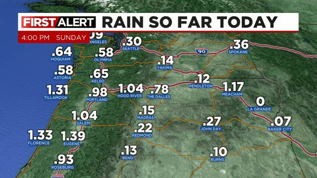
Time for a storm and forecast update. The rain portion of the forecast is working out very well. Salem officially picked up 0.84″ of rain Saturday. So far today we are now over an inch and counting. Here are the Sunday rainfall totals as of 4pm.

Heavy rain came down over a large swath of the central Willamette Valley earlier this afternoon driving up creek levels and causing a few isolated spots of ponding. The Luckiamute River is just one example showing the cause and effect of all that rain.

Other rivers and creeks have also shown sharp rises today. Mill Creek in Salem is currently below flood stage, but it showed a quick jump in its level today as a result of the rain. Looks like it rose almost 2 feet since 10pm last night! No major flooding is expected, and the break in the rain will help ease those creeks some.

Expect just a few scattered showers at most over the next 12 hours as we enjoy a break in the steady rain. The next batch of rain arrives around 4am early Monday morning and will last for a few hours before ending mid morning leaving us with sunbreaks and a very unstable atmosphere tomorrow afternoon.

Monday afternoon through Tuesday morning

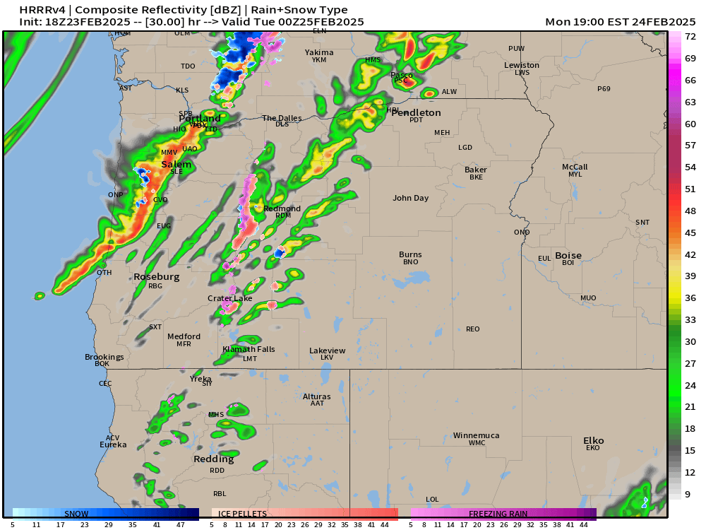
Wild weather will be on tap during this time frame. Heavy downpours, strong gusty winds, and even thunderstorms are possible during Monday afternoon. Dynamics are in place which could lead to some strong thunderstorms -something which is pretty rare for our region. This estimated radar image for 4pm Monday afternoon shows an intense line of showers and storms rolling across the valley. These storms would bring very heavy rain, gusty winds, and of course the possibility for lightning and thunder.

The map above is not gospel truth, but it does give us a general idea of what Monday afternoon might look like by showing the potential for storms.

Additional showers and periods of rain fall during the night Monday through Tuesday morning. Tuesday afternoon should be fairly sunny with only a couple isolated showers leftover.

As far as the wind goes, I’m still expecting the strongest winds to take place Monday afternoon through early Tuesday morning. Wind gusts since Saturday have generally underperformed with most locations in the valley seeing nothing higher than 35mph, which is still breezy, but not strong enough to cause lots of problems.

The storm coming in Monday is a totally different setup. This final round of wind will be a result of a low pressure racing northeast off our coastline. The path the storm is taking is ideal for bringing strong gusty winds to the valley. I’m confident we will see widespread gusts of 40 to 50mph resulting in scattered power outages across the valley.

Tuesday afternoon kicks off a several day stretch of calm and mild weather which should last through Friday.

Stay safe out there!!

Heavy rain, wind set to move in

We had a fun couple of days with snow and ice just over a week ago, and this past week has been fairly uneventful (a nice break for me haha), but this morning it has become very clear that impactful weather is returning to our region. Lots to cover, again, so let’s dive in!!

Main message

Copious amounts of rainfall and strong gusty winds will impact the region beginning tonight and lasting through Monday evening. Expect some power outages and localized flooding. More details below.

Details

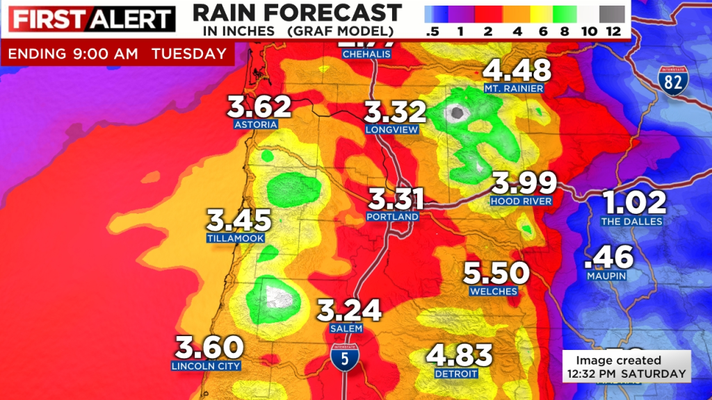
There are three big stories with the series of storms set to move in: heavy rain, strong winds, and the potential for some rare (at least in this part of the world) strong thunderstorms. More on the wind and thunder later. Below are two separate maps showing estimated rainfall totals through Tuesday morning. Very clear message is we have LOTS of rain coming our way over the next three days!!

A good guess based on all the information I have available to me would be 2.5 to 3.5 inches of rain now through Tuesday afternoon.

The rain will range in intensity over the next few days with periods of lighter rain being blown by the wind, and periods of intense heavy rain. Out of all the rain storms we have seen this winter, this is the one that has my attention the most for localized flooding and ponding on roadways. Any locations near flood prone creeks, ditches, low laying areas, or areas with poor drainage could flood with these storms.

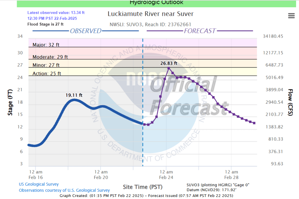
Flood watches and warnings are also up for several coastal rivers, the Pudding River, and the Luckiamute River. Below is a forecasted river height for the Luckiamute River. It shows it rising 13 feet between now and early Monday morning!!

So that’s the rain portion of the forecast with the rain increasing as the day goes on. I’ll be honest, the term “atmospheric river” is way over used in the media; however, it’s appropriate to use it for such a time as this. This will likely be the heaviest rainstorm we have seen here in the mid Willamette Valley this entire winter season.

The wind

After reviewing all the weather models closely, I’m much more concerned about the impact wind will have with this storm than I was just a couple days ago. Right now it appears we will have gusts widespread 35 to 45mph during three separate periods of time. The first period is this afternoon and early evening with winds relaxing a little bit while we sleep. Round two will take place during the day Sunday. Round two will feature stronger gusts than what we see today.

The winds relax big time later Sunday evening through early Monday morning before round three moves in. Round three will contain the strongest winds of the entire storm. Gusts with this round could reach 50mph in some valley locations. Weather apps may be slow to pick up on this still, but Monday looks extremely stormy with additional power outages throughout the day. Peak wind gusts will occur during the daytimes hours on Monday. It will be a wild day at work no doubt! Plan on your power possibly being disrupted at some point over the next three days due to the combo of gusty winds and saturated soils.

Finally, we have rare threat for strong thunderstorms Monday. A warm front will lift through the region Monday morning. Behind the warm front, good forcing up in the atmosphere coupled with sunbreaks ahead of the cold front will create a recipe for thunderstorms that could bring very heavy rain and strong gusty winds to some locations.

Bottom line is we have a very active set of days ahead of us, and this series of storms has my attention more than any others we have seen this year.

If time allows, I would love to update you again on Sunday as I’m confident there will be new changes by then. Stay safe, be ready for power outages, and localized flooding, and enjoy the weekend!

Wild Christmas weather

The quick version is we have multiple strong weather systems aiming for our region. Periods of heavy rain and gusty winds will be common now through Sunday. This will be a typical northwest Oregon rain and wind pattern, but at a slightly more extreme level, and with very few breaks between storm systems. More details below!

Details

Today: In between storms and mostly dry until evening. Rain moves in tonight. Expect around half an inch of rain and wind gusts 20 to 25mph.

Tuesday (Christmas Eve): Showers and sunbreaks as we sit between storms. Around a quarter to half an inch of additional rainfall. Mainly dry during the evening.

Wednesday (Christmas Day): Dry morning. Rain moving in during the afternoon and lasting through the remainder of the night. Over an inch of rain is expected with this storm and wind gusts 40 to 45mph are likely with isolated gusts to 50mph!

Thursday: Steady rain through much of the day with gusty winds at times.

Friday – Sunday: Three more separate storms will arrive one right after the other with very little time in between. 2 to 4 inches of additional rainfall. Winds will continue to be strong with each storm. Wind gusts generally 40 to 45mph- isolated gusts to 50mph.

Add all that rainfall up and we could easily see at least 4 inches of rain this week. Flooding will slowly, but steadily become more of an issue for people living near flood prone creeks, streams, and low laying areas as soils become increasingly saturated.

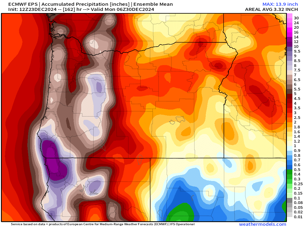
Below is a map showing the estimated mean total precipitation through Sunday. This gives Salem 4+ inches of rain and several inches more in the mountains.

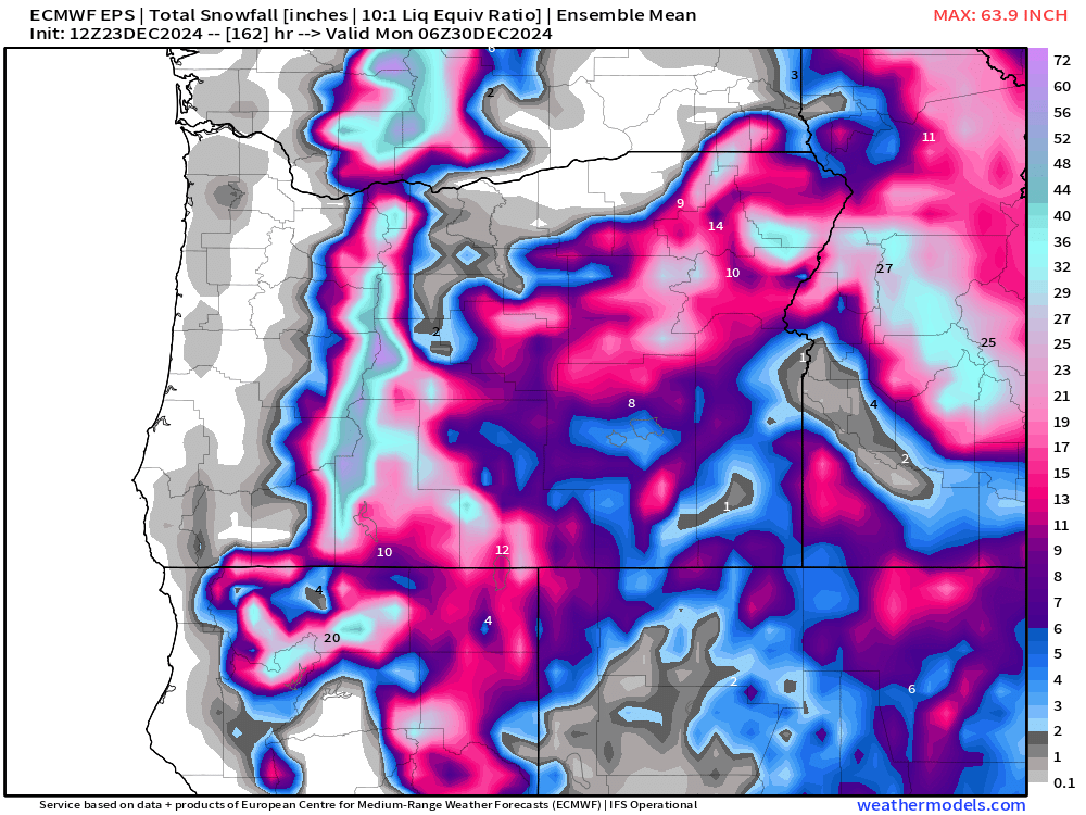
The good news is some of that rain in the mountains will fall as snow limiting our flooding chances. Here’s the mean total snowfall map for the same period of time.

The Cascade ski resorts should pick up a couple feet of snow by Sunday night. The issue is that warmer rain will briefly interrupt this nice snowpack building Thursday night and again on Saturday as snow levels climb above 5000′. Fortunately, we finish the weekend (Sunday) with low snow levels to sorta help top off the mountains with a nice fresh coating of new snow. Worst travel times through the Cascades will be tonight, Wednesday night, Thursday, and again on Sunday.

The Coast

The windiest times will be Wednesday night and early Thursday with gusts up to 65mph!

Thursday night will bring a second round of strong winds. Gusts with this storm should range 50 to 60mph.

Friday night will bring a third round of strong winds. Gusts 45 to 55mph.

Swells will generally stay above 25 feet now through Saturday night! This will be a very extended period of high seas out along our coastline. Swells could reach upwards of 40 plus feet at times later this week. So have fun, but watch out if you head to the coast!

Merry Christmas and have a safe and wonderful time celebrating the birth of our Savior!!

Wet week in review and a look ahead

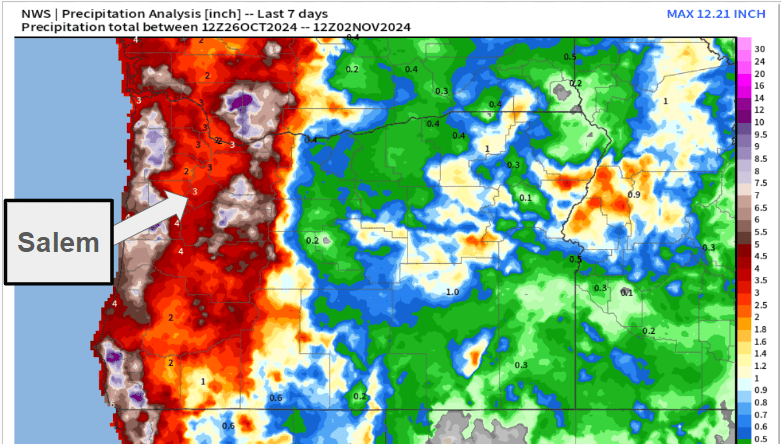
As promised, this week has been very winter like with lots of rain, chilly temperatures, and at times, gusty winds. Below is a county map of Oregon showing total rainfall over the past 7 days. Most of the Willamette Valley has picked up around 3 inches of rain since last Saturday!

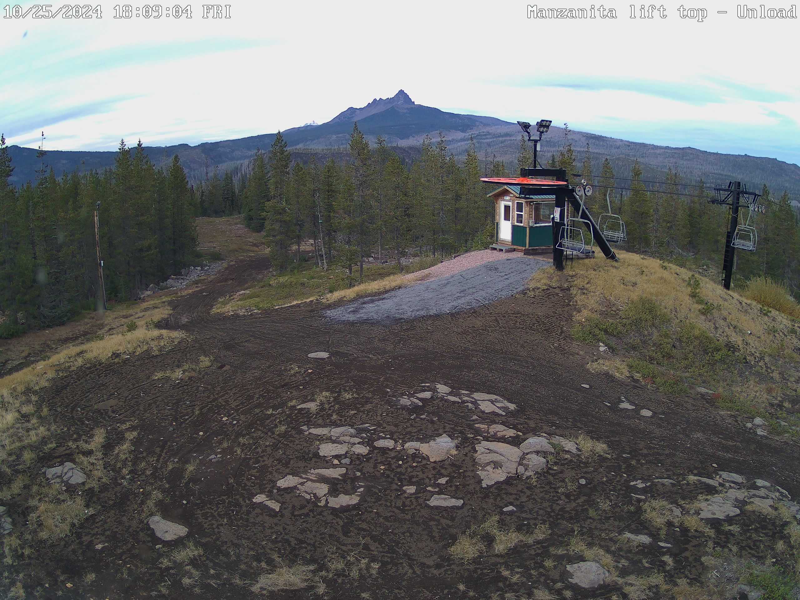
The other big change over the past week has been the well advertised increase in mountain snow. Hoodoo had a 15 inch base early this afternoon with 4 to 8 inches of new snow expected this evening through Sunday morning.

Looking ahead

Tonight: Showers increasing through the evening. Lows tonight in the mid 40s.

Sunday: Mostly dry with some a little bit of sun, and only a slight chance of a shower. Highs into the upper 50s.

Monday: Rain returns as a quick moving cold front sweeps in from the northwest. PM sunbreaks and showers. Highs in the mid to upper 50s.

Tuesday (Election Day): Highs around 57° with a fair amount of sunbreaks, and a slight chance for a brief shower or two.

Wed – Fri: Lots of fog. This time of year can be incredibly foggy, especially after having so much rain. Expect widespread fog each of these three days. Lows will likely bottom out in the 35 to 38° range and highs 49 to near 50 degrees assuming we get some afternoon sunbreaks. Lows could dip to freezing for areas that receive a little more clearing at night.

Next weekend: Rain appears likely, but obviously subject to change being several days out.

No big storms on the horizon at this time, and nothing real out of the ordinary for early November. No signs of any big warm rainstorms to wash away our early snowpack either as temperatures remain a little cooler than normal in the coming days.

October 2024

October may have ended on a cooler note, but overall it was quite mild being 2.8 degrees warmer than normal. As far as precipitation goes, we finished the month above average with a total of 3.8″ to kick off our new water year. Average for October is 3.47″. Over 2 inches of that rain fell during the final week of the month.

Have a great and safe rest of your weekend!