Wild weather update

It’s been a very rainy, and at times, windy week. The wind event Christmas night pretty much met expectations with most valley locations recording gusts between 45 and 50mph, and some locations reaching the 55mph mark. At the peak of the storm about 30,000 PGE customers were without power in Marion County.

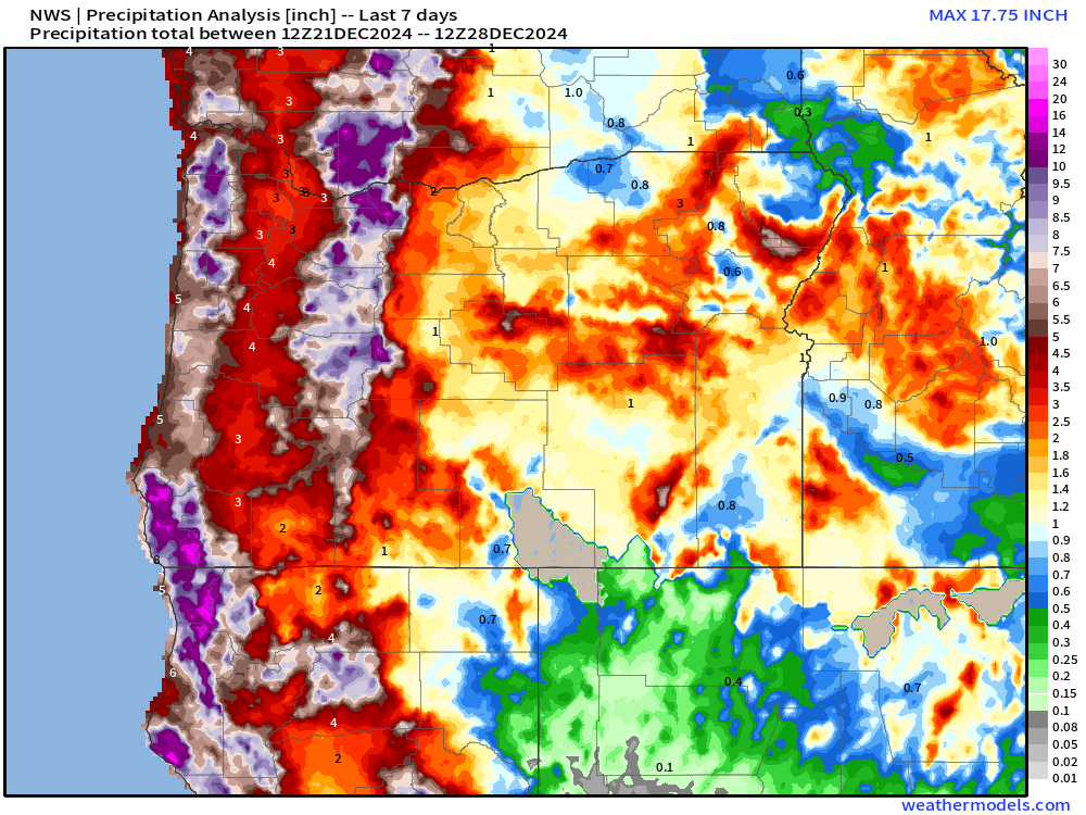
Rainfall has also been fairly consistent and even heavy at times. Here are rainfall totals for the past 7 days.

Generally 3 to 4 inches in the Willamette Valley upwards of 7 to 12 inches of precipitation in both the Coast and Cascade Ranges. Ignore the locations showing no rainfall. Sure, there’s a rain shadow effect, but it’s not that severe. Technical issues are to blame for those spots.

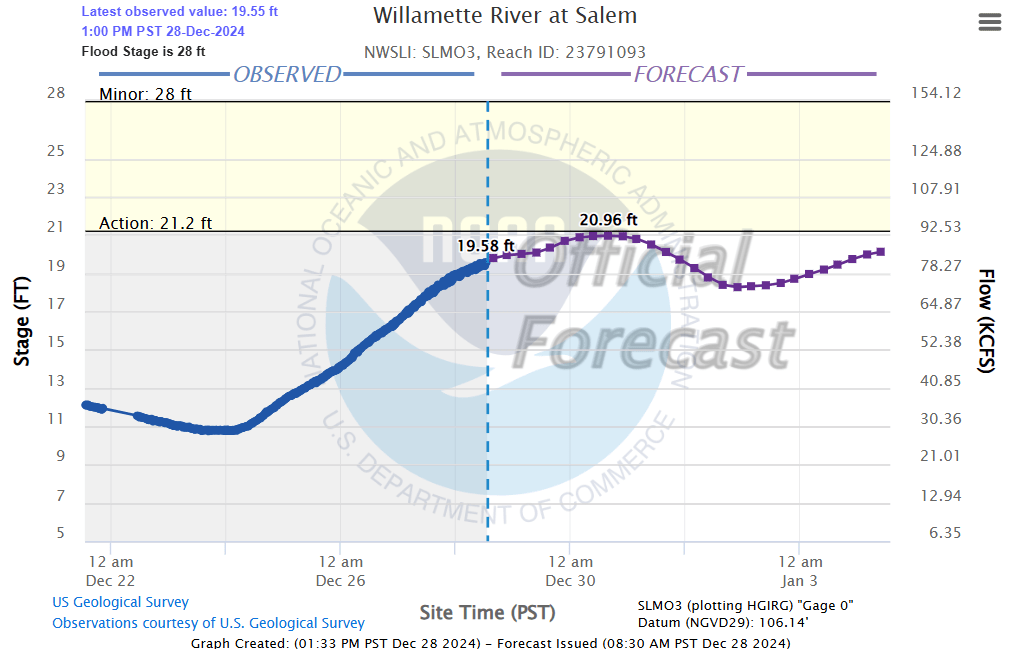
Salem can expect an additional inch of rain now through Sunday. All this rain is adding up and taking a toll on local rivers. Below is a chart showing both observed and forecasted river heights for the Willamette River in Salem.

The Willamette is definitely running full, but it is forecasted to stop just short of causing any major issues or extensive road closures.

The Forecast

Steady rain returns overnight and lasts through Sunday morning. Sunday afternoon will feature showers and downpours with a few sunbreaks mixed in. Winds will once again turn quite strong during the day tomorrow. Gusts 30 to 40mph are possible late Sunday morning and Sunday afternoon.

Snow will be heavy up in the Cascades with 12 to 18 inches of new snow falling above 4000′ tonight through Sunday night.

Monday: More sunbreaks, but scattered showers and downpours will show up from time to time.

Tue & Wed: Tuesday will be dry. Fog is likely Tuesday morning especially, but we should manage some decent sunbreaks during the afternoon. Rain moves in late Tuesday night right around midnight. So there are no guarantees your midnight street runs and fireworks will be completely dry. 😉

Thu – Sun: The rest of the week appears to stay on the wet side with periods of rain and frequent showers.

The rain Sunday could cause a few additional problems for some of you, but once we get through Sunday the threat for flooding will subside for the time being. There are no wind storms on the horizon either. Just regular Oregon rain as we ring in the new year.

Stay safe and enjoy the rest of your weekend!
Merry Christmas and wild weather!

I hope everyone is having a great Christmas! This will be one of the shortest posts ever. Just wanted to highlight the back to back storms on our doorstep.

Storm number one is just beginning to arrive. It will bring 1 to 1.5 inches of rain between now and Thursday evening. The bigger story will be the winds. Winds will gradually increase throughout the day reaching their peak between 9pm tonight and 2am. Widespread wind gusts of 45 to 55pmh are likely. Expect power outages tonight throughout the region.

Thursday will be showery with heavy downpours at times and winds gusting to 30mph.

Thursday night and Friday morning is when storm number two rolls in. Expect another inch plus of rainfall which will push some smaller creeks closer to overflowing, and again, another intense round of wind. For this storm we have the potential for just as strong of winds. Right now I’m expecting widespread top wind gusts to reach 45 to 55mph here in the valley. Expect additional power outages.

Traveling over the Cascades will be rough. Snow levels are fairly high for both these storms, but the tops of all our mountain passes will be prone to heavy wet snow with near whiteout conditions at times this afternoon through Friday morning.

Saturday and Sunday both look wet with more gusty winds at times, but for now let’s enjoy what we have and who we have around us, stay safe, and let’s see what happens.

Wild Christmas weather

The quick version is we have multiple strong weather systems aiming for our region. Periods of heavy rain and gusty winds will be common now through Sunday. This will be a typical northwest Oregon rain and wind pattern, but at a slightly more extreme level, and with very few breaks between storm systems. More details below!

Details

Today: In between storms and mostly dry until evening. Rain moves in tonight. Expect around half an inch of rain and wind gusts 20 to 25mph.

Tuesday (Christmas Eve): Showers and sunbreaks as we sit between storms. Around a quarter to half an inch of additional rainfall. Mainly dry during the evening.

Wednesday (Christmas Day): Dry morning. Rain moving in during the afternoon and lasting through the remainder of the night. Over an inch of rain is expected with this storm and wind gusts 40 to 45mph are likely with isolated gusts to 50mph!

Thursday: Steady rain through much of the day with gusty winds at times.

Friday – Sunday: Three more separate storms will arrive one right after the other with very little time in between. 2 to 4 inches of additional rainfall. Winds will continue to be strong with each storm. Wind gusts generally 40 to 45mph- isolated gusts to 50mph.

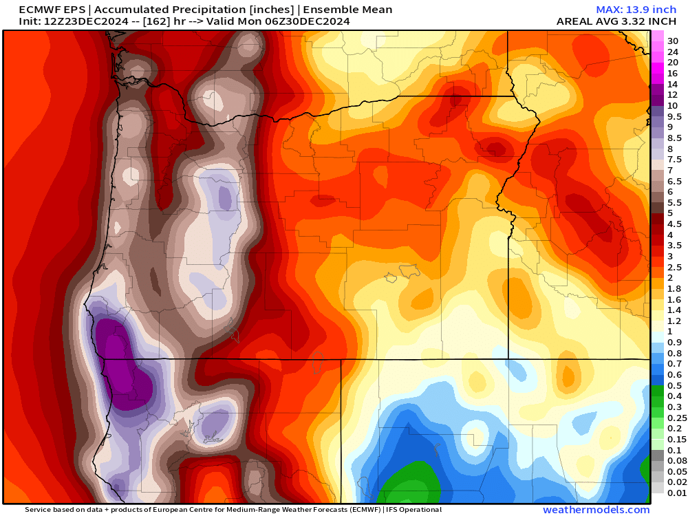
Add all that rainfall up and we could easily see at least 4 inches of rain this week. Flooding will slowly, but steadily become more of an issue for people living near flood prone creeks, streams, and low laying areas as soils become increasingly saturated.

Below is a map showing the estimated mean total precipitation through Sunday. This gives Salem 4+ inches of rain and several inches more in the mountains.

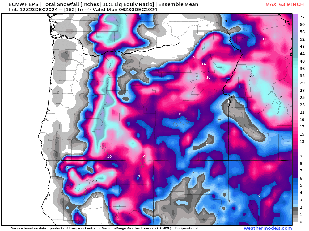
The good news is some of that rain in the mountains will fall as snow limiting our flooding chances. Here’s the mean total snowfall map for the same period of time.

The Cascade ski resorts should pick up a couple feet of snow by Sunday night. The issue is that warmer rain will briefly interrupt this nice snowpack building Thursday night and again on Saturday as snow levels climb above 5000′. Fortunately, we finish the weekend (Sunday) with low snow levels to sorta help top off the mountains with a nice fresh coating of new snow. Worst travel times through the Cascades will be tonight, Wednesday night, Thursday, and again on Sunday.

The Coast

The windiest times will be Wednesday night and early Thursday with gusts up to 65mph!

Thursday night will bring a second round of strong winds. Gusts with this storm should range 50 to 60mph.

Friday night will bring a third round of strong winds. Gusts 45 to 55mph.

Swells will generally stay above 25 feet now through Saturday night! This will be a very extended period of high seas out along our coastline. Swells could reach upwards of 40 plus feet at times later this week. So have fun, but watch out if you head to the coast!

Merry Christmas and have a safe and wonderful time celebrating the birth of our Savior!!

Chilly dry weather

We are now entering into what will be a long stretch of dry weather. It may not feel dry with the cold damp fog hanging over our heads, but no additional rain is expected between now and at least next Wednesday (December 4th). Excellent news for people traveling by road! Our dry spell will be marked with fog that lasts for long periods of the day, or in some cases the entire day, occasional sunbreaks, and chilly temperatures.

Expect widespread frost possible each morning over these next several days with many of us seeing our first hard freeze of the year at some point this week. These strong ridge setups in the dead of winter are tricky because if the fog holds then temperatures can also hold steady throughout the day, but if the airmass manages to dry out a little then we could see a wider rang of temperatures.

For now I’m going with lows of 28 to 33 degrees – again depending on the extent of fog, and highs in the low 40s. Today will actually probably be our “mildest” day of the week as we are just entering into this inversion pattern. Our temperature as of 10:45AM is already a “balmy” 43°.

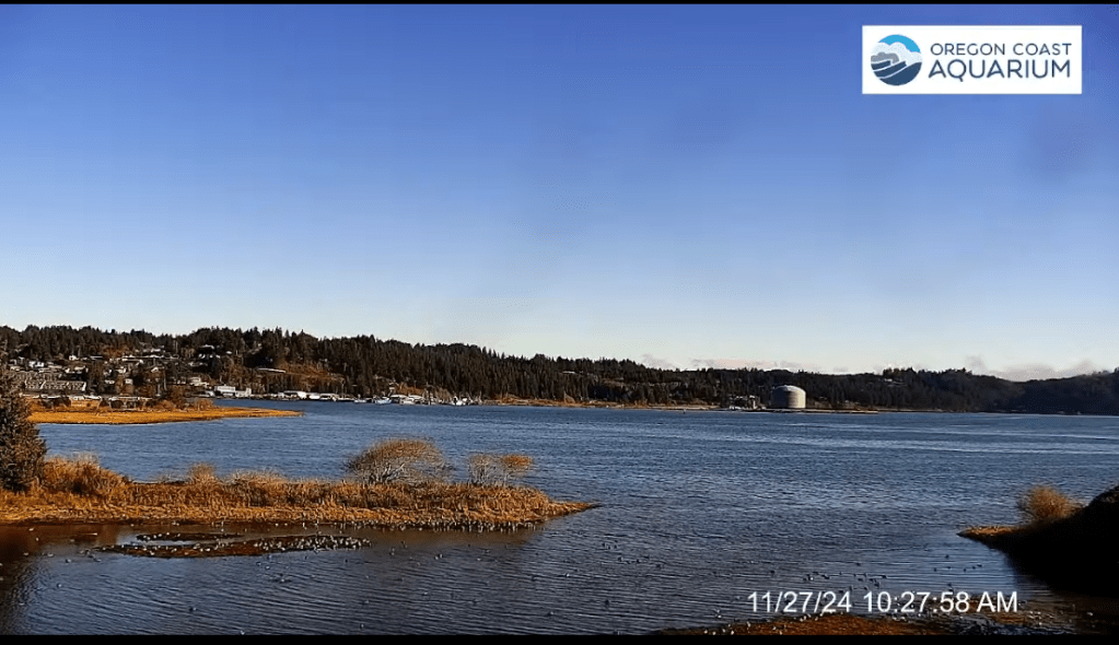
Remember, in these inversion setups both the coast and the Cascades are often times clear and sunny. Not warm, but escaping the fog can be nice. Here’s a snapshot of Newport Bay courtesy of Koin News and the Oregon Coast Aquarium.

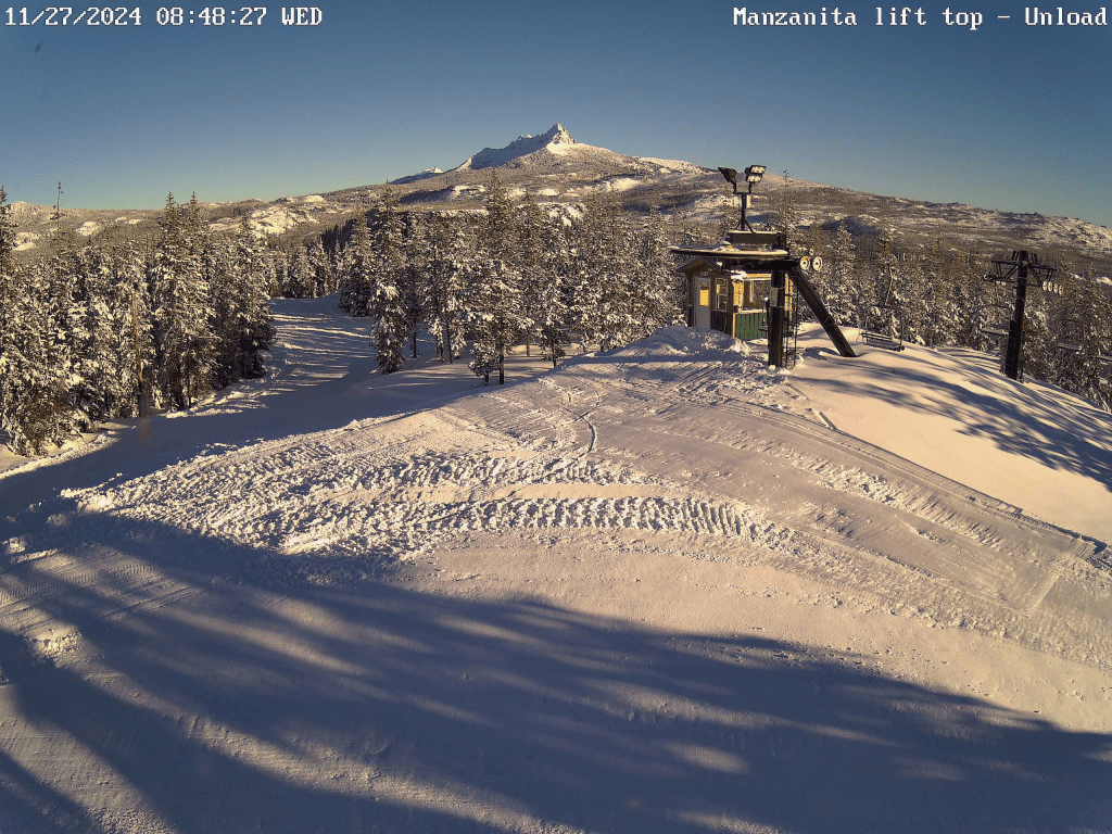
Next we have a beautiful sunny picture from Hoodoo earlier this morning. Brilliant sunshine up above the inversion, and with 34 inches of snow at their base they are all set to open this Friday per their website. A great start to the year!!

God created a pretty incredible world, and I hope we can both take care of it and enjoy it. Stay safe, have fun, enjoy the people around you, and happy Thanksgiving!!