Wild weather!

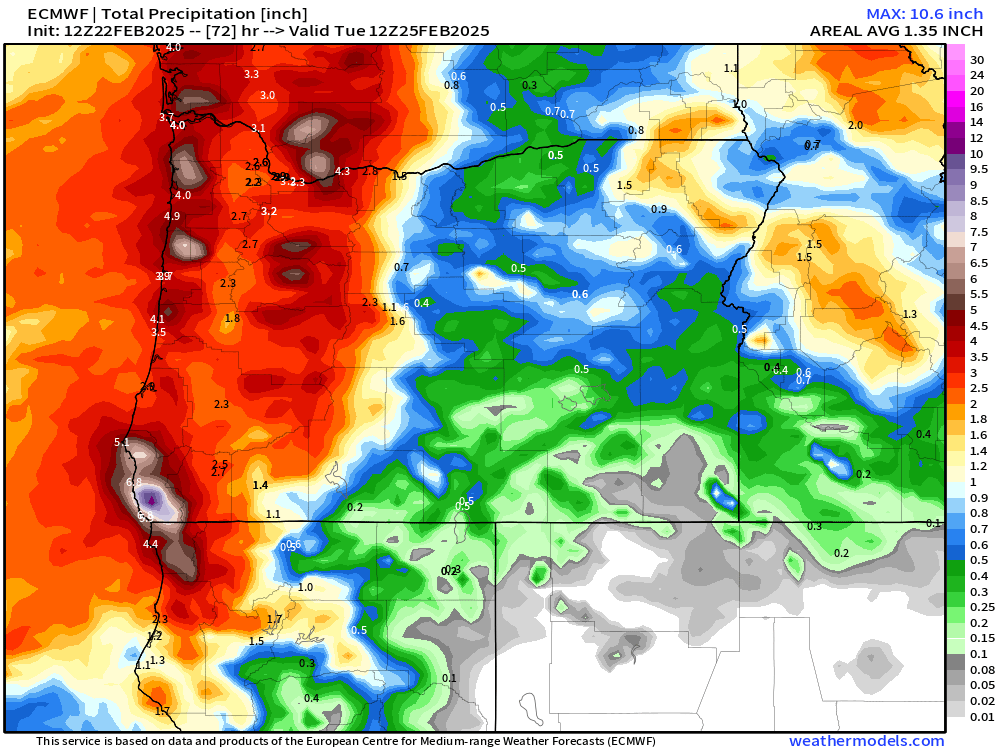
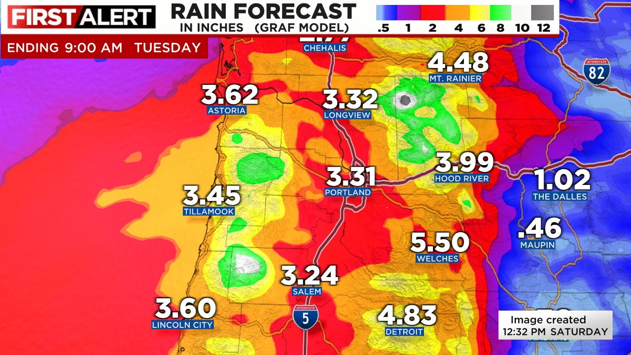
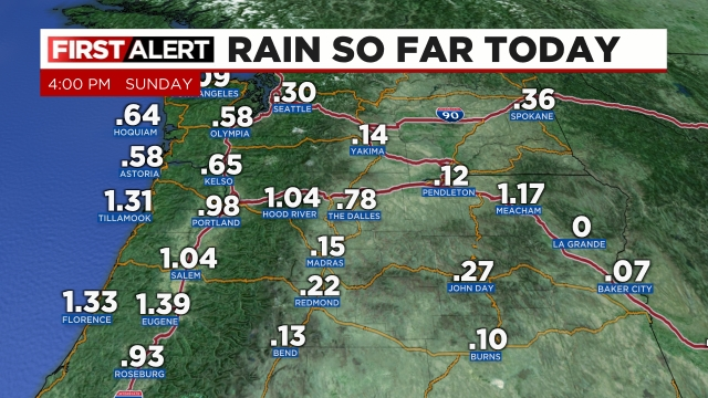
Time for a storm and forecast update. The rain portion of the forecast is working out very well. Salem officially picked up 0.84″ of rain Saturday. So far today we are now over an inch and counting. Here are the Sunday rainfall totals as of 4pm.

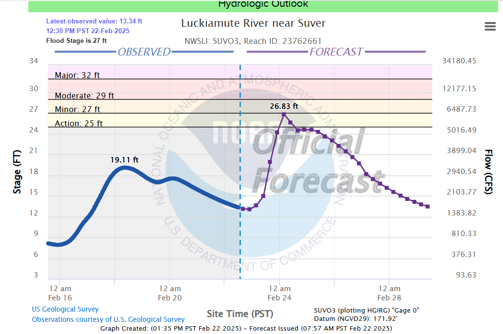
Heavy rain came down over a large swath of the central Willamette Valley earlier this afternoon driving up creek levels and causing a few isolated spots of ponding. The Luckiamute River is just one example showing the cause and effect of all that rain.

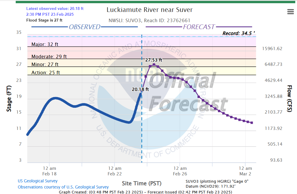
Other rivers and creeks have also shown sharp rises today. Mill Creek in Salem is currently below flood stage, but it showed a quick jump in its level today as a result of the rain. Looks like it rose almost 2 feet since 10pm last night! No major flooding is expected, and the break in the rain will help ease those creeks some.

Expect just a few scattered showers at most over the next 12 hours as we enjoy a break in the steady rain. The next batch of rain arrives around 4am early Monday morning and will last for a few hours before ending mid morning leaving us with sunbreaks and a very unstable atmosphere tomorrow afternoon.

Monday afternoon through Tuesday morning

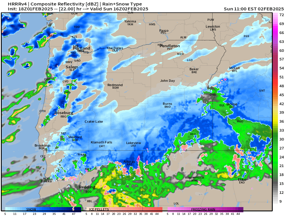
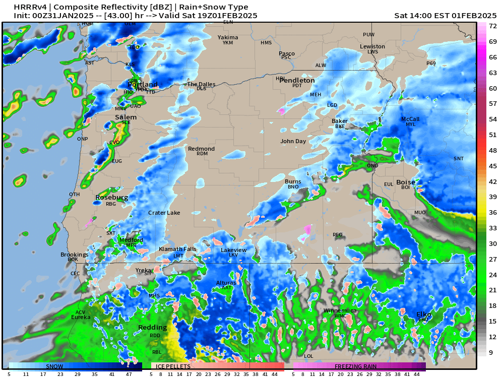
Wild weather will be on tap during this time frame. Heavy downpours, strong gusty winds, and even thunderstorms are possible during Monday afternoon. Dynamics are in place which could lead to some strong thunderstorms -something which is pretty rare for our region. This estimated radar image for 4pm Monday afternoon shows an intense line of showers and storms rolling across the valley. These storms would bring very heavy rain, gusty winds, and of course the possibility for lightning and thunder.

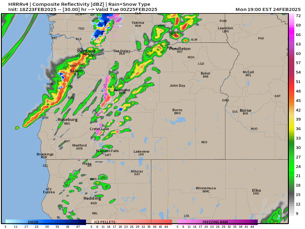
The map above is not gospel truth, but it does give us a general idea of what Monday afternoon might look like by showing the potential for storms.

Additional showers and periods of rain fall during the night Monday through Tuesday morning. Tuesday afternoon should be fairly sunny with only a couple isolated showers leftover.

As far as the wind goes, I’m still expecting the strongest winds to take place Monday afternoon through early Tuesday morning. Wind gusts since Saturday have generally underperformed with most locations in the valley seeing nothing higher than 35mph, which is still breezy, but not strong enough to cause lots of problems.

The storm coming in Monday is a totally different setup. This final round of wind will be a result of a low pressure racing northeast off our coastline. The path the storm is taking is ideal for bringing strong gusty winds to the valley. I’m confident we will see widespread gusts of 40 to 50mph resulting in scattered power outages across the valley.

Tuesday afternoon kicks off a several day stretch of calm and mild weather which should last through Friday.

Stay safe out there!!

Heavy rain, wind set to move in

We had a fun couple of days with snow and ice just over a week ago, and this past week has been fairly uneventful (a nice break for me haha), but this morning it has become very clear that impactful weather is returning to our region. Lots to cover, again, so let’s dive in!!

Main message

Copious amounts of rainfall and strong gusty winds will impact the region beginning tonight and lasting through Monday evening. Expect some power outages and localized flooding. More details below.

Details

There are three big stories with the series of storms set to move in: heavy rain, strong winds, and the potential for some rare (at least in this part of the world) strong thunderstorms. More on the wind and thunder later. Below are two separate maps showing estimated rainfall totals through Tuesday morning. Very clear message is we have LOTS of rain coming our way over the next three days!!

A good guess based on all the information I have available to me would be 2.5 to 3.5 inches of rain now through Tuesday afternoon.

The rain will range in intensity over the next few days with periods of lighter rain being blown by the wind, and periods of intense heavy rain. Out of all the rain storms we have seen this winter, this is the one that has my attention the most for localized flooding and ponding on roadways. Any locations near flood prone creeks, ditches, low laying areas, or areas with poor drainage could flood with these storms.

Flood watches and warnings are also up for several coastal rivers, the Pudding River, and the Luckiamute River. Below is a forecasted river height for the Luckiamute River. It shows it rising 13 feet between now and early Monday morning!!

So that’s the rain portion of the forecast with the rain increasing as the day goes on. I’ll be honest, the term “atmospheric river” is way over used in the media; however, it’s appropriate to use it for such a time as this. This will likely be the heaviest rainstorm we have seen here in the mid Willamette Valley this entire winter season.

The wind

After reviewing all the weather models closely, I’m much more concerned about the impact wind will have with this storm than I was just a couple days ago. Right now it appears we will have gusts widespread 35 to 45mph during three separate periods of time. The first period is this afternoon and early evening with winds relaxing a little bit while we sleep. Round two will take place during the day Sunday. Round two will feature stronger gusts than what we see today.

The winds relax big time later Sunday evening through early Monday morning before round three moves in. Round three will contain the strongest winds of the entire storm. Gusts with this round could reach 50mph in some valley locations. Weather apps may be slow to pick up on this still, but Monday looks extremely stormy with additional power outages throughout the day. Peak wind gusts will occur during the daytimes hours on Monday. It will be a wild day at work no doubt! Plan on your power possibly being disrupted at some point over the next three days due to the combo of gusty winds and saturated soils.

Finally, we have rare threat for strong thunderstorms Monday. A warm front will lift through the region Monday morning. Behind the warm front, good forcing up in the atmosphere coupled with sunbreaks ahead of the cold front will create a recipe for thunderstorms that could bring very heavy rain and strong gusty winds to some locations.

Bottom line is we have a very active set of days ahead of us, and this series of storms has my attention more than any others we have seen this year.

If time allows, I would love to update you again on Sunday as I’m confident there will be new changes by then. Stay safe, be ready for power outages, and localized flooding, and enjoy the weekend!

Winter wonderland!!

Woo hoo! Snow has been widespread across the entire mid Willamette Valley! It’s clear now that we have either hit the upper end of my forecasted snow totals or surpassed them for this point in our winter storm with more on the way tonight through Friday morning.

At the moment we are currently in between the rounds of heavier precip, and the “heating of the day” has helped major roads clear up a bit, but conditions go down hill tonight as temperatures drop and as round #2 moves in, so don’t get stuck out there thinking all is well.

What’s ahead?

More snow tonight with freezing rain and sleet mixing in. This second wave of moisture still looks quite “juicy” lol with a solid half inch of melted down precip (or more) with round #2. I currently expect at least a little bit of freezing rain or sleet to mix in tonight before changing back over to all snow; however, models have already been trying to push the cold air out of here too quickly, and so for the moment I’m leaning towards more snow and not as much in the way of ice.

Either way, winds continue to breeze out of the north, and temperatures will be plenty cold enough that whatever falls from the clouds will be frozen or will freeze on contact (freezing rain). My best guess is an additional 2 to 5 inches of snow with some freezing rain. If this storm continues to overperform I could see us surpassing those totals too! There are always little twists and turns with our winter storms here…

Snow will come to an end Friday morning, but with the colder than expected temperatures and increased snowfall, we should plan on road conditions improving very SLOWLY through the day on Friday with side roads remaining in rough shape.

Refreezing Friday night with clearing skies will lead to more issues again on side roads and less traveled streets through early Saturday morning before finally thawing out the rest of the way.

One additional thing I want to mention is how the Salem Airport temperature sensor has been regularly reporting a bit warmer than surrounding stations. Even warmer than weather observation spots in downtown and east along Lancaster Drive. Mark Nelson posted this graphic from the other day showing just how off it’s been and that he has tracked this for a couple years now. He does excellent work for Fox 12 and I appreciate his attention to details and to locations outside the PDX metro if you ever need a good forecaster to watch on TV.

So if you’re curious why your weather sensor at home has you in the upper 20s, but your weather app says otherwise, well now you know! Even right now you can see it is way off compared to the rest of the city and local area sitting at 34° while the rest of us are in the upper 20s to around 30°.

Stay safe, and keep on enjoying the snowy and wintry weather!! 🙂

Winter storm Thursday and Friday

This will be a very short post, but an important one. I’m confident a winter storm will impact our region beginning Thursday morning through at least Friday morning. I’ll have a nice post filled with more details and shiny graphics tomorrow. For now, plan on weather disrupting your daily routines beginning Thursday morning with rough travel conditions lasting through at least the first half of Friday. This means snowy and icy roads during this period of time – even during the daytime hours on Thursday.

The situation this time is much more simple compared to last week which is why I have such high confidence two days out. We are not dealing with isolated showers, the timing does not have to fall in the middle of the night, and we don’t have to worry about southerly winds. We will be plenty cold, and moisture will be abundant with chilly breezes continuing out of the north for the duration of this event. The perfect recipe for wintry weather.

How much precip will fall, and what form of frozen precip will we experience are the two big questions still up in the air. At the moment it looks like the Salem area will see a mix of snow, sleet, and freezing rain through the course of the storm. Temperatures will be below freezing all day Thursday through at least Friday morning, so accumulations will occur on the roads. My best guess would be 1 to 3 inches of snow, some sleet, and a little bit of freezing rain. Keep in mind forecasting snow totals is tricky when we are bouncing back and forth between snow and ice.

Friday afternoon or for sure by Saturday morning we should warm up to begin the melting process. It’s mid February, so the snow and ice won’t stick around super long, but for the two days it’s here, it will effect your life to a degree.

Happy Tuesday and stay safe out there. I leave you with a map of the regional temperatures as of 7AM this morning. Brrrrrrr!!!!!

Icy roads tonight

This past Wednesday was an exciting day. I would guess that everyone at least saw snow in the air. It did not stick in most places, but some neighborhoods got a brief coating of white, and the higher hills around town received accumulating snow. These showery patterns with southerly winds are always so borderline. So many factors to consider which really can’t be forecasted very well far in advance. Had we been two degrees colder, or had the showers arrived earlier while it was still dark then we could have woken up to a snowy or more like slushy winter wonderland. We’ve seen it go both ways here. Overall I’m fairly happy with how the forecast has gone. Hopefully I’ve portrayed just how tricky forecasting snow with this particular setup really is.

The forecast

A few very isolated showers tonight through early Monday morning, and by isolated I mean extremely isolated, but it’s just enough to keep us from being totally dry. I greatly dislike when the weather does that lol… Because of the showers, we also have increased odds of icy streets or even a random (light) dusting of snow – especially in the higher hills. Watch out for icy roads the next few nights and mornings.

Monday – Wednesday

Count on it being cold, but mostly sunny and dry. Lows in the lower 20s by Wednesday morning. This part of the forecast feels pretty certain to me. Highs will gradually cool off each day under the influence of a NE breeze.

Mon: Low of 28°. High of 44°.

Tue: Low of 24°. High of 42°.

Wed: Low of 21°. High of 39°.

Looking ahead

This coming week has the potential to be even colder with a more classic setup for widespread snow or ice. The ingredients will be in place. Cold air, winds out of the north and east, and a low pressure approaching from the southwest. This exact setup is how we get our biggest snow and ice storms. Some examples of this setup in the past include last January, the ice storm just before Christmas 2022, the big ice storm we saw in February 2021, and the snowstorm we saw (for you old timers like me haha) way back in December 2016. These are all examples of this “classic setup.” No southerly winds, no scattered showers like we have seen this week. Just cold air and steady precip. Still not an easy forecast, but several of the trickiest factors are removed from the equation in this scenario.

The first factor yet to be determined is how deep the cold air will be. If the cold air is shallow, we end up with more sleet or freezing rain – something we have seen more often these past several years it seems. If the cold air is deeper then we have the potential for widespread snowfall. I like to share the graphic below to help illustrate this point.

The track of the low pressure next week will also determine the impact on us locally. Too far south and we stay dry and cold, too far north and we see all rain or freezing rain, but if it goes somewhere in the middle then we end up with a nice snowstorm. I’ve drawn a few lines on the map below. This map shows low pressure (storm centers) for Thursday morning. Ignore the lows to west of the slanted line as they are part of another storm system. I’ve placed a blue smiley face to mark western Oregon hehe. In a nutshell, lows to the north of the top horizontal line would generally give us either rain or a brief shot of freezing rain or snow before changing to rain. Lows to the south of the bottom line would for the most part leave us high and dry, and finally, the majority of the lows between the two horizontal lines would give us a snowstorm.

So you can see why making a call on how much snow, or if it will even snow is not really possible just yet. History tells me that by Monday evening I should have a much better idea of what to expect.

We do know that it will be cold for the next several days. Again, keep an eye out for icy roads and parking lots, and have a fun and safe rest of your weekend! I’ll be sure to keep you all in the loop once details become more ironed out.

Preparing for wintry weather

Practical steps/most important info

Forecasting way out in time can be tricky, but it is very clear to me that we will be dealing with icy roads, snow, and cold at various times for the next few weeks. There are strong signals we will be in this wintry pattern for awhile. If you have snow tires and you think you would use them over the next few weeks then this weekend is the perfect time to put them on.

In the forecast below I’ve highlighted road conditions with red font, and important messages and snow totals in bold font.

If you don’t like driving in the snow or on icy roads, and you have a flexible schedule, then run your errands this weekend or else Mon & Tue afternoons. Plan on the nights and mornings being the worst for driving, and plan on slippery roads possibly all day long on Wed & Thu.

The current forecast for each individual day is just the best guess I can give with the information at hand. Don’t focus on details too much. Just keep in mind your travel plans and daily life could be effected by snow or icy roads pretty much each night and morning this week, and possibly all day long Wednesday and Thursday.

Details

Sunday: Anyone could wake up to a little snow. Yes, this will be our first shot as seeing snowfall. Wet snow, graupel, and rain are all likely with the heavier showers during the day. Roads could briefly become covered, but afternoon temperatures will melt things off. The vast majority of roads tomorrow should be fine. Chances for snowy roads always go up with elevation in this type of pattern. Expect a few sunbreaks at times during the day, but not as many as we have today. Estimated radar for Sunday morning around 8am does a good job at conveying the main message of scattered showers and snow showers.

Mon & Tue: A few snow showers are possible each morning. Some people will wake up to snow, some of us to ice, and some with mostly bare roads. Hard to pinpoint when we are dealing with showers. Snowy and icy roads should clear up by late morning each day. This means life should be able to go on as normal roughly 10am to 6pm each day. Nothing – 2 inches of snow possible each morning. Anything that falls out of the clouds during the daytime hours will be in the form of snow thanks to the cold atmosphere, but it’s much less likely to stick during the day unless you find yourself at a higher elevation.

Wed: More widespread snow showers likely. 1 – 4 inches of snow possible at any elevation and even during the middle of the day as colder air works it’s way south. Roads could be bad all day long Wednesday. Subject to changes still.

Thu: Back to sunbreaks & scattered snow showers. Another inch or two of snow is possible during this time frame, and colder temperatures will make it tough for roads to melt off.

Super Bowl weekend and the week after look cold. Way too far out for details, but strong signals that we remain in a wintry pattern with more snow opportunities likely to present themselves.

The maps below illustrate this quite well with cold anomalies centered over or very near to the pacific northwest this Sunday, Tuesday, Thursday, and even all the way into Tuesday the 11th with no sign of the pattern really changing. This lends me higher than usual confidence that we will be dealing with wintry weather for quite some time…

At the moment it’s sunny at my house, so I might head outside for a bit. Stay safe and enjoy the wild weather as much as possible. 🙂

Wintry weather

The forecast and weather the past almost 3 weeks has been incredibly stable.  I’ve personally enjoyed the sunny weather, but it’s all coming to an end.  Lots going on and much to cover, so let’s dive in!

Super short version

We have a rainy and breezy day for Friday. Saturday will be chilly with sunbreaks and showers. Sunday – Wednesday we maintain a shower and sunbreak pattern, but temperatures will be cold enough that snow could accumulate anywhere in the valley, and at times even along the coast. Accumulations are most likely between 6pm to 10am (during the nighttime and early morning hours). By the time we get to Tuesday and Wednesday, temperatures might be cold enough for snow to stick at anytime of the day. No major snow storms are currently being forecasted, but with cold air moving in and storms close by, things could easily change…

Details

Friday:  Rain and wind will greet us as we head out our doors Friday morning.  Classic northwest stormy weather.  Rainfall could be rather heavy at times, and winds will generally gust in the 20 to 30mph range, so not too wild.  Expect sunbreaks later in the day.  Cooler air begins to move in and our temperatures start dropping.

Saturday:  Showers and sunbreaks.  Accumulating snow should stay in the Coast Range and Cascade Range during this day. This estimated radar image actually portrays my thoughts very well. Notice blue (snow) staying in the our mountain ranges, and also notice the showery nature of the precip with some areas getting very little action.

In general, this type of scattered shower pattern is what we can expect through next Wednesday with the biggest difference being the gradual arrival of colder temps as time goes on.

Sunday & Monday:  Showers and sunbreaks.  Accumulating snow will be limited to the nighttime and morning hours, and only some of us will see snow due to the scattered nature of the showers. Because of those factors, there really is no way to pinpoint exactly who will score snow in this type of pattern. Afternoon temperatures rise to around 40 degrees each day.  Throw in a few sunbreaks and road conditions during the daytime hours should be good for normal activities here in the valley.

If this was regular shower pattern then nobody would notice if they got a few hundredths of an inch of rain versus a third of an inch. In this case it makes a huge difference between a few harmless flakes or a blanket of 3 inches of snow.

Tuesday & Wednesday:  Similar to Sunday and Monday except we will have a slightly colder airmass these days which means a heavy snow shower could briefly cover all surfaces (including roads) even during the middle of the day. Highs in the upper 30s and lows around 29/30°. For now I’m going with nothing to 2 inches of snow each night, and up to an inch possible during the daytime hours.

Thursday – Saturday:  A wide range of solutions are out there, but I can tell you with a fair amount of confidence that we stay cold with additional snow chances very much on the table. In fact, there are strong signals we stay in a colder pattern for the foreseeable future beyond next weekend.  Winter is making it’s comeback!

Hazards

Icy streets. Due to the widely scattered nature of the showers we are expecting, skies will have better chances at clearing out each night. This means icy streets for your neighborhood – even if you don’t get snow. Frozen water leftover from showers can cause just as many issues. As the week goes on and temperatures cool off even more, I expect road issues to last longer into the daytime hours. Just be extra careful on those paved surfaces in the coming days.

Things I’m watching for:

An increase in moisture would equal significant snow totals. This is totally in the realm of possibility with this specific setup. The chart below shows some hefty snowfall totals (legit snowstorms) mixed in there for Salem. At the moment such outcomes are in the minority, but things can change quickly.

On the other hand, should moisture trend to the drier side (also unlikely, but possible), then this time frame could end up being rather uneventful.

My best guess

Expect scattered snow accumulations of nothing to 2 inches both Sunday and Monday mornings with lows around 32 and highs around 40°. Remember, some of us will probably end up with nothing.

More widespread snow accumulations of 1 to 4 inches are possible on Tuesday and Wednesday. Still not guaranteed due to the showery nature of the pattern, but odds increase thanks to the colder temperatures. Highs in upper 30s. Lows 28 to 30°.

The mountains will of course see tons of snow. 2 to 3 feet of new snow between now and next Thursday for the Cascades, and at least several inches up in the Coast Range. Be prepared for snowy roads whether you are traveling east or west of the valley.

Stay safe and happy Friday! I’m sure I’ll have additional updates as often as time allows!