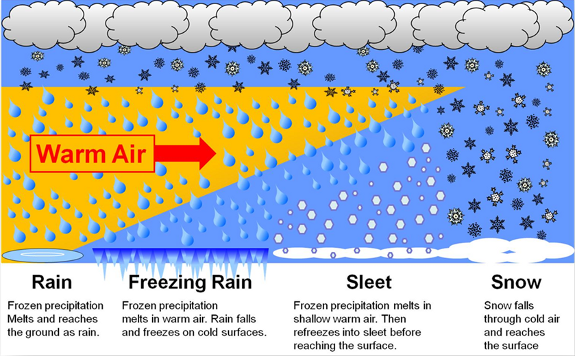
It’s been a long time since I posted. The weather has generally been extremely uneventful, plus I’ve been busier than usual with work and side projects (including the garden). Regardless, I figured it was time for an update.
The forecast
Wed & Thu: Onshore flow increases pushing in a stronger marine layer along with a very weak front. This will result in highs in the low to mid 70s. Expect plentiful AM clouds with PM sun breaks. We could see a sprinkle Wednesday morning; otherwise, these two days will remain dry.
Fri: PM showers. A cold atmosphere up above will result in the possibility of thundershowers too. Some of the downpours could be quite heavy. Highs right around 60°.
Sat: Additional showers and thundershowers with a more steady rain likely during the late afternoon and evening hours. This will produce a widespread soaking rain for areas west of the Cascades. Downpours will have potential to be heavy. Highs will struggle to reach 60°
Sun: Showers wrap up with much of the day being dry. Just keep in mind that showers could still take place during the day on Sunday. Highs into the lower 70s again.
Mon – Wed: Partly cloudy to mostly sunny skies. Highs around 80° each day. Lows will start out chilly right around 50 to 53°.
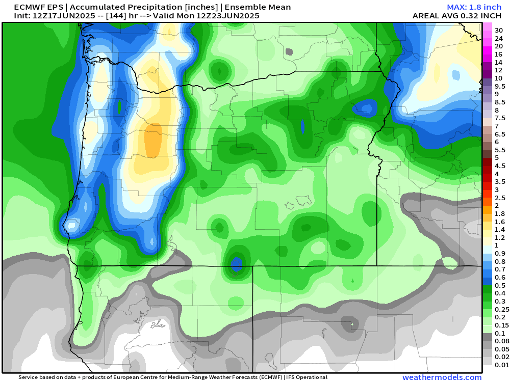
Rain totals look to range from half an inch to just over an inch of rain here in the Willamette Valley. This will bring much needed precipitation to our region!
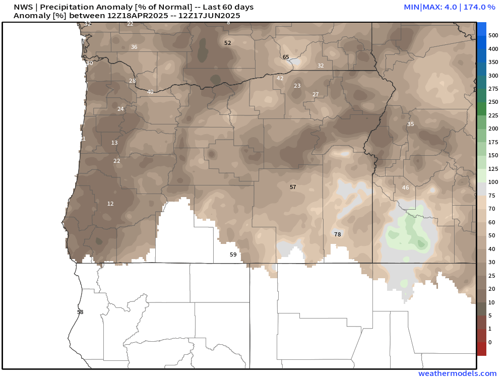
Aside from the first week of April, we have been unusually dry this spring. The few “rainy” days we have seen the past 8 weeks have not produced more than a third of an inch on any given day. The map below shows percent of normal precipitation locations have picked up between April 18th and June 17th. Many valley locations are running at a mere 15 to 25% of average.
We are running slightly better precipitation wise than the dry and hot spring of 2021. That year brought our most intense heatwave ever with temperatures soaring above 110° throughout the Willamette Valley. That was an awful experience. Luckily, no signs of hot weather.
As far as temperature goes, May 2025 went down in the history books as only being 0.2° above normal. For all practical purposes that’s considered average. At the moment, June is running 3.5 degrees above normal, a special thanks to the hot spell last weekend. That number will fall dramatically by this time next week due to the much cooler weather moving in.
For reference, I added a chart showing total rainfall for Salem during the month of May going back to 1997.
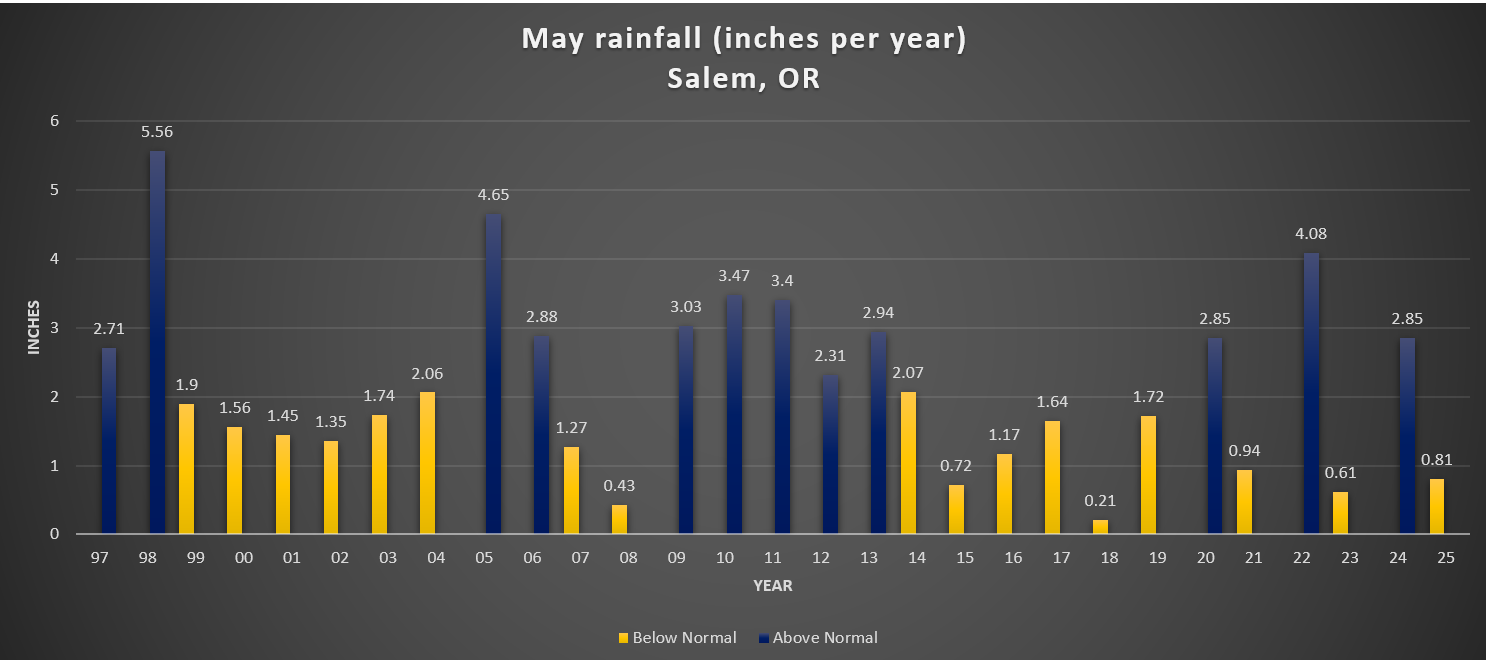
There is no clear trend here. The only notable thing I could see was the tendency for totals to range more drastically over the past several years, but in the grand scheme of things, several years is hardly a trend.
We’ll see where we end up for rainfall in June. For now enjoy the continued dry weather, and keep in mind that Friday through Sunday will be generally wet.
The Cascades
Planning on hiking or camping up high? Well, plan on some snowfall Friday night through Saturday night. Snow levels will dip down low enough for the volcano summits/peaks to pick up several inches of snow. Timberline, the tops of the sisters, Jefferson Park, Crater Lake, and any other peaks above roughly 5500 feet could see snow this weekend. Keep this in mind. Spots along the PCT (Pacific Crest Trail) could also see snowfall impacting hikers and backpackers this weekend. By Sunday afternoon the summer sun returns and the snow up there will quickly begin melting off again.