Election Day 2020

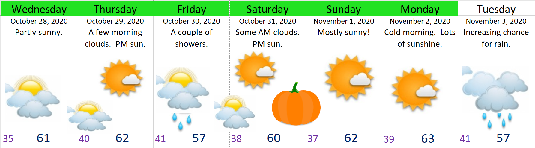
We finally had some rain today after a very dry October. Looking ahead we have a bit of weather action coming up this week to cover including some mountain snow.

Highlights

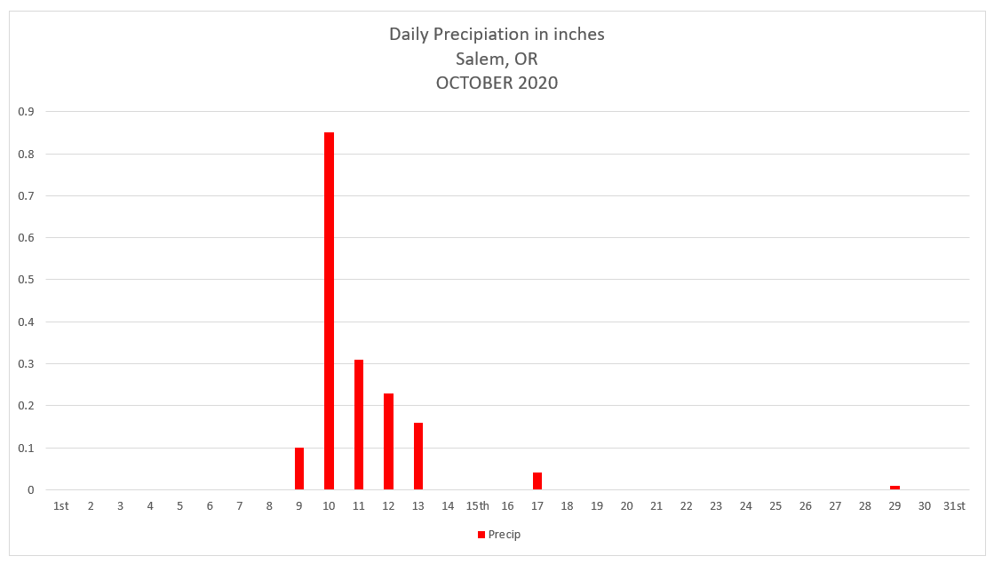
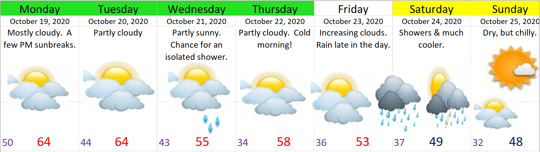
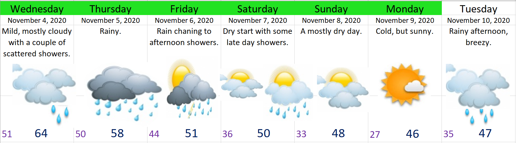
1.) Thursday & Friday will be especially wet. Expect a little more than an inch of rain over these two days.

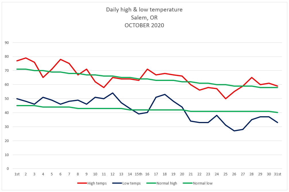
2.) Much cooler weather. Highs will be in the 40s Sun – Tue and lows will once again drop into the 20s Monday morning.

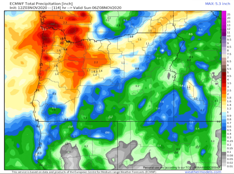
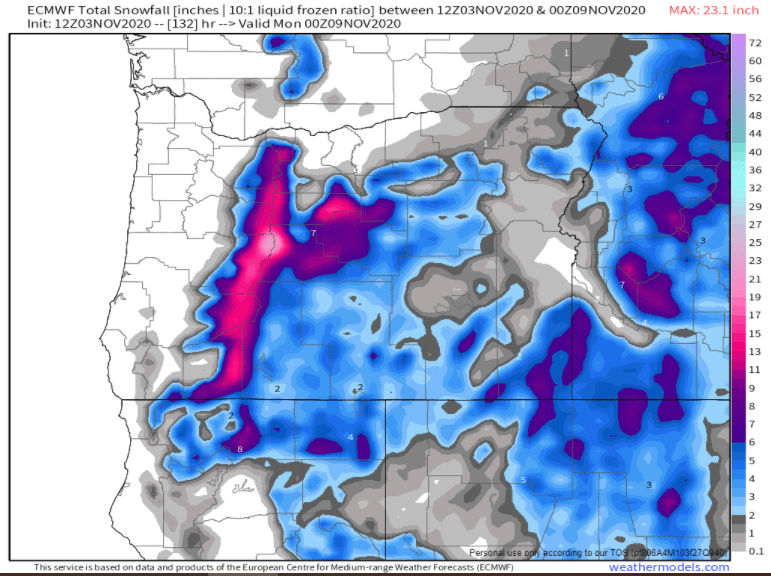
Here are a couple of maps showing both the total precip and total snowfall measured in inches through Saturday night. Main take away is it’s looking wet down here and snowy up in the Cascades with generally 10 to 15 inches expected starting early Friday morning as the snow level slowly drops down to near 3000′.

I’m very glad to have you all as faithful followers. You may notice I avoid posting anything political in my forecasts, or at least I try to. My desire is to keep it that way as it’s extremely nice for a change reading about something that isn’t political, polarizing, frustrating, or upsetting as most political things are; however, I think active involvement in our system is very important, so if you have not voted yet, be sure to fill your ballot out and drop it off by 8pm tonight!!

Okay, take care, happy election day, and remember, at the end of the day we are all still God’s children. 🙂

October 2020

October 2020 is done. Just two months to go before 2020 is also in the bag… The highlights for the month would probably be the consistently dry weather we saw (24 dry days this month), and to a lesser extent, the couple of storms we had early in the month which brought wind gusts of 35 to 40mph.

This graph shows Salem’s actual high and low temps per day along with the average high and low temps for October.

Temperature

Warmest high temp was 79°  October 2nd   

Coldest high temp was 50°  October 25th  

Warmest low temp was 54°  October 12th

Coldest low temp was 27°  October 26th

3 days with lows at or below freezing.

Precipitation

Salem saw rainfall on 7 days during October with .85” of rain falling on the 10th making that the wettest day for the month.

October 2020 Summary

Despite having a number of warmer than normal days with lots of mild afternoons, October ended at only 0.77° above average thanks to the cooler weather, and more specifically the cold mornings we experienced the last several days of the month. As far as precipitation goes, October 2020 saw only 56% of our normal precip making for a much drier than normal month.

Looking ahead

November is our first real month of our winter/storm season. It’s the second wettest month of the year beat out only by December. As far as valley snow goes, November snow is quite rare. In fact, 2010 was the last time Salem recorded sticking snow in November, and the time before that was in 2006, so perhaps one could say we are due for a little this year. 😉

Even more overdue and more likely than November snow is a wet November. The last really wet November occurred back in 2012. Every November since then has been either right around average or drier than normal. Last November was one of the driest on record with less than one inch of rain for the entire month! I have a feeling this month will be a bit more active….

November rainfall per year for Salem, OR going back to 1990.

Wrapping up October

Nothing special going on this week.  We had some cold (for October) weather these past few days. Salem had a low temp of of 27° Monday morning. Brrrr!! Check out some of the other low temps from around the region on this Fox 12 News graphic I borrowed.

Monday morning low temps
EXTENDED FORECAST

1.) Like I said, nothing exciting coming up. Just more partly cloudy – mostly sunny days, with chilly mornings and mild afternoons.

2.) A couple of showers are likely Friday, but still no sign of any significant rainfall. By Saturday we will be totally dry again.

3.) Maybe some rain by next Tuesday as a slightly stronger storm rolls through…

Warm October

Up until these past two days this month has been warm. Currently we are running about 3.5° above normal for the entire month which is quite impressive and one of the warmer Octobers we have had in a long time, but things are starting to balance out a little. Yesterday cool air moved in, and this morning we had our coldest low temp of the season with a low of 33°. This weekend even chillier air moves in bringing low temps below freezing for the first time since last April.

The storm coming in Friday evening will bring some much cooler weather, but not a whole lot of precipitation at all. I’m thinking nothing more than a few showers Friday afternoon/evening and maybe a leftover shower or two Saturday morning before drying out. Plan on Saturday afternoon being a dry, but cool.

Sun – Tue: Even colder with morning lows 28 – 32 degrees, and highs 50 – 54°.

Looking further out I see no sign of any significant rain. Warm or cold the one thing that’s been consistent this month has been dry weather. A moderate to strong La Nina is still being predicted for this winter (November – March) which means this unusually dry weather may not last much longer, so I suppose we should continue to enjoy it while it lasts. In case you missed my incredible write up on what I think might happen this winter you can follow the link below. 😉

https://bryanweatheralert.com/2020/09/28/winter-2020-2021-outlook/

Alright, enjoy the cool fall weather and stay safe & healthy out there!

October 18th

We have another several days of pretty typical October weather on the way with (maybe) a change towards something more exciting as we head into next weekend.

Here’s the next 7 seven days.

Highlights

1.) A couple of brief showers possible tonight and again on Wednesday, but overall another mostly dry week ahead.

2.) Our first frost of the season (widespread) is possible on Thursday. Something to think about if you have temperature sensitive plants.

3.) Watching what happens with a more powerful storm moving in Friday night and Saturday. I’ve highlighted those two days in yellow as there is a lot of uncertainty with the track of the storm which affects how windy, cold, and rainy it will get here. For now I expect rain Friday evening along with some gusty winds. Saturday looks chilly with some leftover showers & sunbreaks. This storm also has the potential to bring the first significant snowfall of the year to the Cascades. Lots to watch with this system, so stay tuned.

4.) If we don’t hit freezing Thursday we will almost certainly hit it Sunday morning as we come under the influence of chilly Canadian air.

Fun fall weather

If you’re like me, well okay, if you at least share my love for weather, lol, then you probably enjoyed both the windy/stormy weather last night and the nice sunbreaks today. We have another round of wind & rain coming up Tuesday morning. Winds will again gust 25 to 35mph along with periods of rain.

Tue: Rainy at times and windy. Gusts 25 – 35mph.

Wed: Mostly dry with a couple of leftover showers. More showers up in the mountains and the further north you go.

Thu – Sat: Partly cloudy, mild afternoons, and dry. Lows in the 40s and highs 64 – 70°.

Sunday: The largest change to the forecast is the chance for a few showers on Sunday.  Most of the weekend will still be dry, but if you’re outdoors on Sunday keep in mind you may have to dodge a couple of brief downpours before it dries back out.


Weekend forecast

Happy Friday!! I hope you all are enjoying October. We have a very wet Saturday on tap with close to an inch of rain expected tonight through the day tomorrow. Breezy too with gusts early Saturday morning of 20 – 30mph. Rain should move in tonight around 10pm.

1.) Sun & Mon: Showers at times with more breezy/gusty winds up to 30mph Sunday night.

2.) Tuesday starts off dry with rain moving in late afternoon.

3.) Wednesday will be the opposite with a few showers early morning; otherwise a mostly dry day.

4.) Thursday through next weekend (the 17th & 18th) looks dry for any outdoor activities you may have planned.

Below is the estimated total precipitation through Wednesday. These maps aren’t perfect; however, they do a decent job of showing roughly how much precip can be expected and where it will fall.

Basically we can expect about 2″ over the next several days here in Salem with more in the mountains and along the coast. A good fall soaking bringing rain even east of the Cascades which will help end the fire season over there! As mentioned, dry weather returns Wednesday afternoon and should last through next weekend.