Monday night snow update

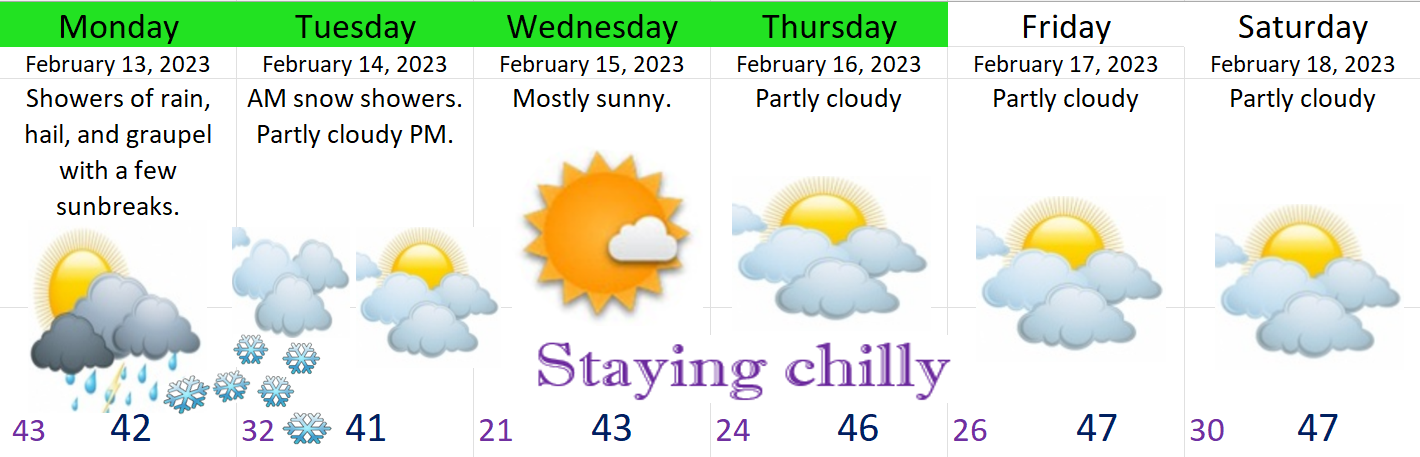
Many of us are preparing for bed (as we should) on this Monday night, and it’s still very much up in the air as to whether or not we see snow tomorrow morning. Here’s 4 important points for you to know.

1.) This scenario favors higher elevations (south and west Salem hills etc).

2.) This scenario actually favors the eastern Willamette Valley too just a little.

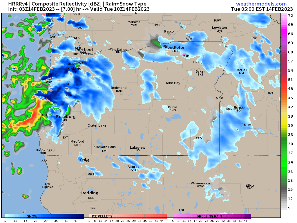
3.) We are looking at snow showers which makes predicting exactly who gets snow and who doesn’t very tricky. Check out this simulated radar image showing heavy bands of snow over some sections of the valley, but with some gaps in between.

4.) My fourth and final important point is I expect anywhere from a slushy trace of snow to close to 3 inches anywhere within the Willamette Valley depending on your location and the intensity and duration of the snow showers over your neighborhood.

Snow melts during the day and afternoon and evening plans can continue on as normal. Just keep in mind it will be very cold – especially Tuesday night.

Take care and stay safe!

Monday morning update

Good morning! We have a wild 24 hours of weather in store. Here’s my latest thoughts and your extended forecast.

Expect a wide range of showers and downpours today with hail, rain, and graupel (mix of snow and hail) falling at any point with sunbreaks in between.

More cold air moves in tonight while a batch of organized showers moves through giving us a chance for a couple inches of snow. More on this in an update tonight, but plan on Tuesday morning’s commute being potentially snowy for a number of areas around here.

We dry up and “warm” up Tuesday afternoon into the low 40s which means afternoon and evening plans should be mostly good to go.

Very cold night Tuesday night and dry for the rest of the week.

The Cascades will see a foot of new snow or more in some spots through Tuesday morning, and snow will also begin to cover the Coast Range this evening, so keep in mind if you are needing to travel through these regions.

Okay, happy Monday everyone!!! 🙂

A cool Valentine’s Day

Happy Saturday! I have a quick update regarding the potential snow for this coming Monday night and Tuesday. Here’s the day by day breakdown for you.

Sun: Very similar to today’s weather. Still chilly, but with afternoon sun and signs that the seasons are changing and spring is getting closer. Enjoy the nice weather outside if you can! 🙂

Mon: a cold front moves through bringing numerous showers and breezy winds. Some of the showers could be heavy and could contain hail or graupel enough to briefly turn the ground white.

Mon night – Tuesday: Colder air will continue to pour onshore dropping snow levels near the valley floor. Models are indicating that a batch of more organized showers could move through during the overnight hours Monday night/early Tuesday morning. This batch of snow showers will have the potential to drop 1 to 2 inches of snow across the Willamette Valley or at least parts of it. I will have an update Monday evening with the latest.

For now plan on snow possibly effecting your life Tuesday morning. This will be a wet slushy snow, so by lunchtime (if it even snows at all), roads will be totally fine I’m thinking. Again, look for one more update Monday early evening with the latest details as we get closer to the event.

Wednesday morning will begin in the mid 20s and highs will top out in the mid 40s making for a chilly, but sunny and dry day.

That’s all for now. Busy with family today and cleaning house, but wanted to give you all a little update as I know rumors about snow have been all over the place lately.

Take care!! 🙂

Colder weather this weekend

Happy Friday to you all. 🙂 It’s been several days since I first mentioned the possibility of colder weather coming, and colder weather is definitely still on track to move in this weekend; however, it’s looking like it will be a quick hitting blast with minimal impact on your daily life. Details below:

Today: A lot of clouds around with a few isolated showers, but still mostly dry.

Saturday: Showers increasing during the afternoon and evening hours. Winds will eventually switch to the north bringing in colder air. Sadly (for all of you snow people out there – myself included), it is currently looking like we dry out pretty quickly once the cold air begins to move in. Honestly I don’t expect more than a few flurries.

Sunday: Some roads could be icy Sunday morning, but even this day should go on as normal.

Monday and Tuesday: Cold, but dry. Overnight lows will dip into the lower 20s (upper teens even in some areas). Highs in the upper 30s to around 40°. Lots of sun at least 🙂

Basically nothing super wild. Colder for sure, but for the moment it looks like it won’t be effecting our daily lives all that much unless your plans take you into the mountains where 5 to 10 inches of snow will fall over the weekend.

Take care and look out for more updates should anything change. 🙂

Dry week ahead

We have a chilly, but dry week on tap. Expect to see lots of fog, frost in the mornings, and not much warmth. No rain this week through Thursday with rain moving back likely on Friday or Saturday. Nothing going on this week…..

There is one (possibly major) thing which is beginning to catch my eye, and that is a pattern change to much colder weather. The type of pattern that sometimes gives us snow and ice.

Nothing certain yet, but keep in the back of your head the possibility that the weather could disrupt your life and regularly scheduled plans starting as early as Sunday (the 29th) and lasting through the first week of February. I suspect I’ll be posting a little more often here in the coming weeks, so stay tuned for updates. No need to panic, freakout, or cancel plans yet. Just wanted to give my loyal followers/viewers a heads up that signs are growing indicating big changes could be coming.

Have a wonderful week!!!

Soggy northwest weather

Happy new year to all of you! There is nothing special or really crazy going on with our weather in the near future. We have mostly dodged the worst of the storms lately as they have been aimed at California. I imagine you’ve heard about some of the wild weather they have seen down there with heavy heavy rain, gusty winds, and feet and feet of mountain snow.

Here in western Oregon, Salem is on our 7th day in a row of seeing rainfall, and yet we are running about 40% below average for the month. The rain we have seen (so far) this month has been light with plenty of dry breaks in between. Again, most of the action has stayed to our south.

The remainder of today will be breezy with some heavier showers moving through.

Monday will be similar to today with some gusty winds and bands of showers.

Tue & Wed: More dry weather than wet. In fact most of the daytime hours both these days should be dry with rain coming back to the valley late Wednesday afternoon/early evening.

Thu & Fri: Fairly wet days.

See? Nothing exciting. Just regular Oregon rain.

Have a wonderful week!

Big storm approaching

Quick post tonight. We have a massive and very powerful storm heading our way. Bottom line it that beginning tonight and lasting through most of Tuesday, we will experience the strongest winds we have seen in years. Gusts 50 to 60mph are likely here in the Willamette Valley and up to 80mph at the coast. Additionally we will see well over 2 inches of rain within the next 24 hours. Flooding is a concern for all areas near small and mid sized creeks and streams. Here’s the estimated rainfall totals through Tuesday evening.

Expect 2 plus inches here in the valley and up to 4 inches along the coast. Expect power outages (possibly widespread) due to the heavy rain and powerful winds. Furthermore, highway and road closures seem like a good bet especially along the coast and in the mountain ranges. Snow levels will be high to begin with resulting in rain up in the Cascades and on the ski resorts.

The rest of the week will feature snow levels 3000 to 4000 feet which means the ski resorts will quickly regain any lost snow.

Some 5 to 6 feet of snow will fall Tuesday afternoon through Saturday with more on the way for the first week of January!

Expect to need chains traveling through the Cascades every day beginning Tuesday afternoon with snow falling each day.

The weather has been rough lately, but we are making it. We avoided lots of power outages with the ice storm thanks to more of the precip falling as sleet (ice pellets) and very little falling as actual freezing rain, plus precip was not all that heavy. Of course it was so dang cold that, as predicted, that the roads were awful Thursday night through Friday night before we thawed out Saturday morning.

Bottom line is make sure you bring in things that could blow around/over and just know that it has been several years since we experienced winds this strong, so be ready for downed trees and power outages. Winds will pick up late tonight. Hang in there and stay safe!!