Sunday through Tuesday: Very warm. Highs 90 to 92°.
Wednesday: More reasonable with mostly skies and highs around 83°.
Thursday through Sunday: Highs in the upper 70s to low 80s with cool mornings starting out in the lower 50s each day and more cloud cover, especially during the morning hours.
Details
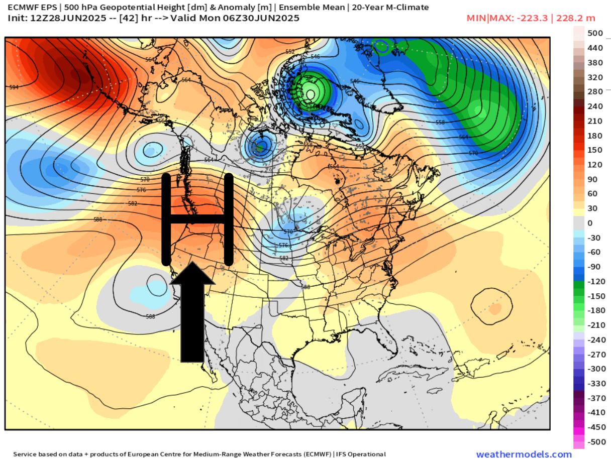
For the next three days we will be under the influence of a high pressure bringing us very warm weather. The map below shows this very nicely with the warm airmass centered directly above Oregon Sunday night.
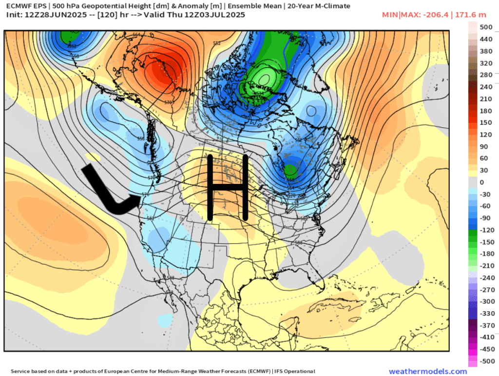
The second half of the week will be dominated by marine onshore flow. This next map illustrates this well showing the high pressure being pushed to the east allowing cooler air from the ocean to move inland early Thursday morning.
Overall, it’s looking mostly dry the next 7 days with some minor exceptions, and depending on your travel plans, these exceptions could effect you.
Exception #1. A few thunderstorms and showers are likely in the Cascades and in central Oregon Monday through Wednesday.
Exception #2. Drizzle and a few sprinkles are possible along portions of the coast specifically Thursday through Sunday. During those four days the onshore flow is stronger which will bring in marine air. During summertime, these setups can produce very light (and spotty) precipitation along the coast and even in parts of the Coast Range.
So, after a few very warm days to begin the week, we return to the stronger onshore flow which will return temperatures back to normal or even slightly below normal just in time for the 4th of July weekend. Much more comfortable than the scorcher we saw last Independence Day. 🙂
Wed – Fri: Cooler with lots of clouds and chances for sprinkles/light showers.
Sat – Mon: Warmer again with mostly sunny skies.
Wet weather recap
The rainy weather did not disappoint. In fact, Friday and Saturday were the rainiest back to back days since the first week of April! The map below shows rainfall totals from the weekend.
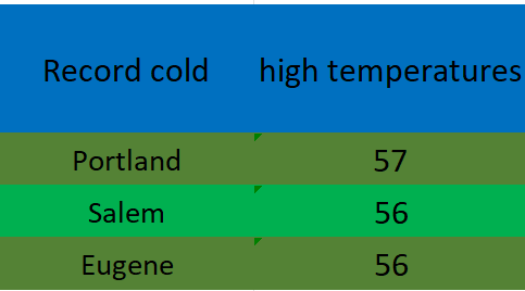
A solid half inch to inch in the valley and over an inch to two inches up in the foothills and mountains. The low pressure and steady rain was accompanied by chilly temperatures too. Record low high temperatures were set on Saturday all over the valley.
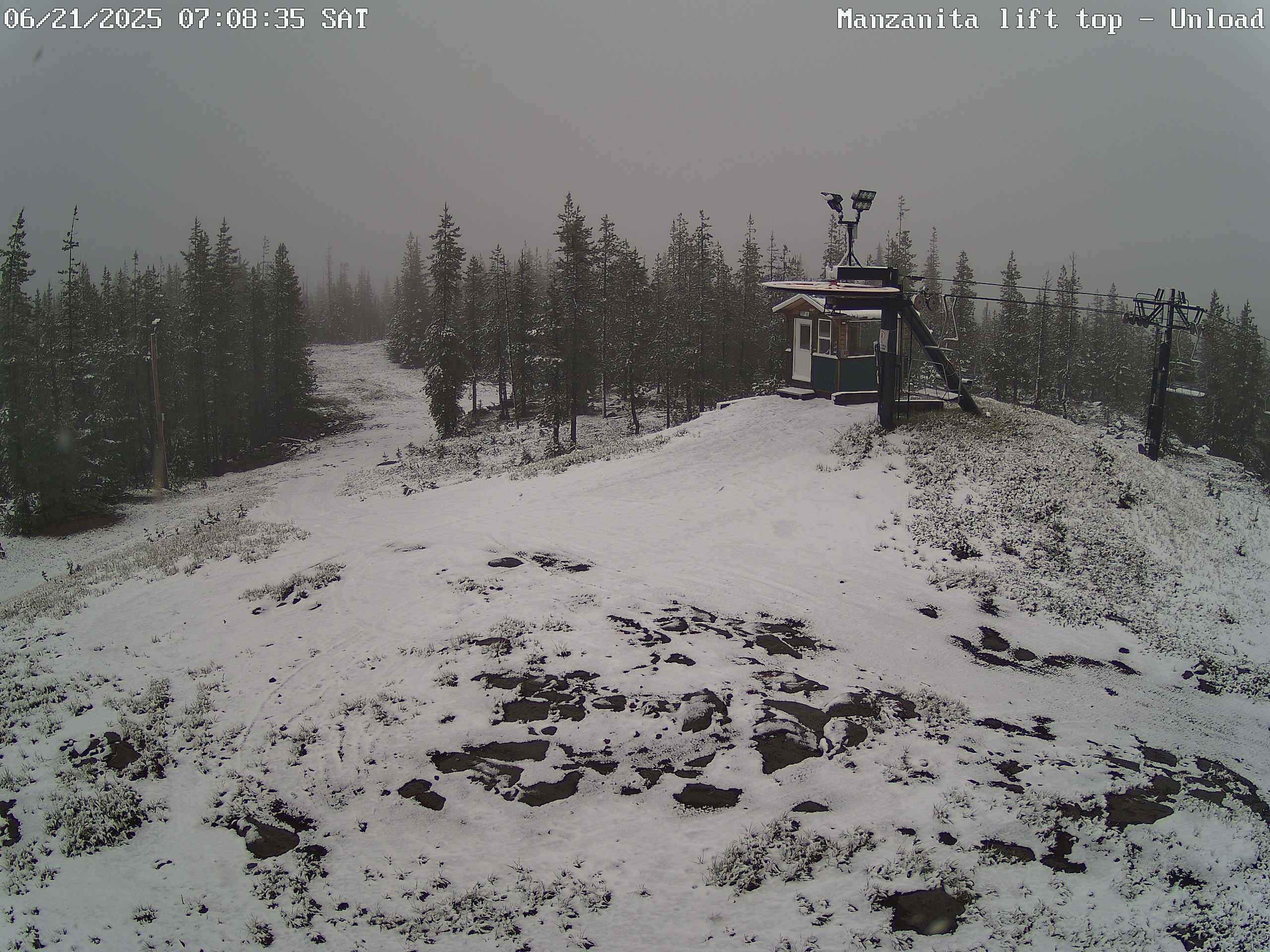
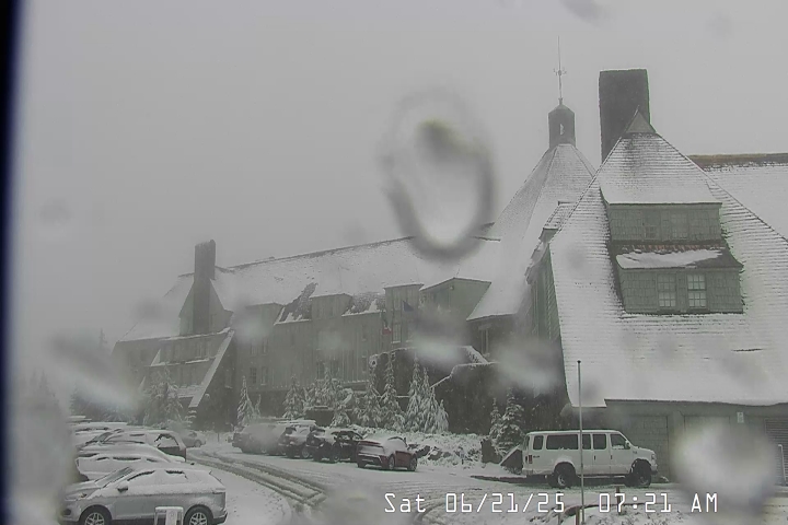
Snowfall also made it’s way to the Oregon Cascades. These two images show snowfall on Hoodoo and up at Timberline Saturday morning. Fun to see snow falling up there on the first full day of summer!
Forecast details
Tue: Very similar to the weather we saw today. Highs in the low 80s.
Wed – Fri: Each day will feature a very slight chance of drizzle or a few light sprinkles. Nothing widespread or heavy. Lots of cloud cover with sun breaks mixed in at times. Highs in the low 70s and early morning lows 53 – 55°. Best chance for any light showers or sprinkles looks to be Wednesday and Thursday with a lower chance on Friday.
Sat: Sunshine returns with highs in the lower 80s and mostly sunny skies. A real nice day after a refreshing start that morning with lows in the low 50s.
Sun & Mon: Sunny and warm with highs in the mid to upper 80s.
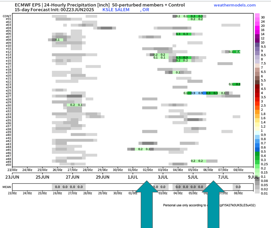
Looking further out to the first week of July it still appears we could have another shot at a few showers. Too far out to say with certainty, but there are enough individual members (horizontal lines) calling for rain at some point during the first week of July that it has my attention.
The biggest take away I see is that there is no sign of hot weather the next two weeks. Some upper 80s, but nothing prolong or real significant. I’ll keep an eye on that 4th of July forecast, but in the meantime enjoy the nice weather.
It’s a beautiful Thursday afternoon and temperatures are in the low 70s here in the mid Willamette Valley. I have a short update on our wet weather plus a look into next week and beyond below.
The forecast
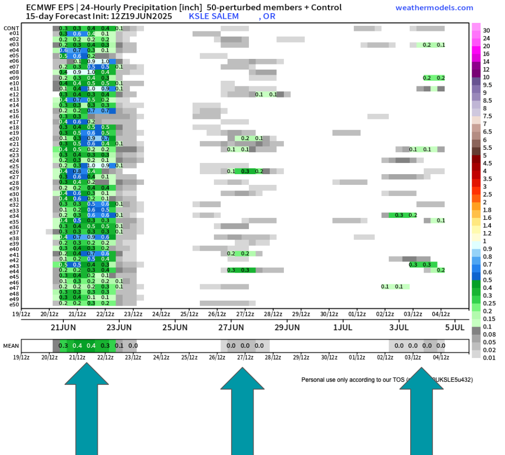
Our wet weekend is still very much on track. This weekend’s showers and rain show up very nicely on this ensemble chart. Remember, time goes from left to right on here and each horizontal line is a predicted outcome, and in this case, the outcome is precipitation. When viewing these charts we look for general agreement and trends.
Besides the soaking rain this weekend, you can spot the real light rain/sprinkle chance showing up for next Thursday (the 26th). I also noticed a higher than usual number of ensembles predicting a little bit of rain maybe the first few days of July. I’ll keep a close eye on that.
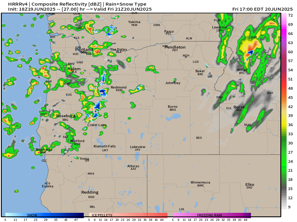
Friday will feature showers with just a few sun breaks here and there between showers. Quick hitting thunderstorms and heavy downpours are possible for all valley locations. The simulated radar image below does a good job depicting this scenario around 2pm Friday.
On Saturday we will actually see some steady rain during the morning/early afternoon hours before transitioning to a few showers later in the day. Again, downpours are definitely possible for all areas west of the Cascades. Steady rain will make it hard for high temps to top 60°.
Sunday: Expect this day to be mostly dry, but an isolated shower or two will require people outdoors to keep an eye to the sky. Overall a much better day weather wise for outdoor activities. Highs around 71°
Mon & Tue: Partly cloudy (more clouds during the morning hours) with lots of afternoon sunshine. Highs 80 to 83°
Wed: Increasing onshore flow again will lower highs back into the mid 70s with partly cloudy skies.
Thu & Fri: Could see another sprinkle or light shower (similar to what we just saw this past Wednesday) at any point during this time frame, but especially Thursday morning. Highs in the mid low to 70s with sun breaks mixed in.
Sat – Mon: June will finish on a warm note with highs in the mid to upper 80s and mostly sunny! A huge contrast to what we will experience this coming weekend.
Take care, enjoy the west weather the best you can, and don’t forget to pray for the people God puts on your heart today. Our world could use more prayer right now.
It’s been a long time since I posted. The weather has generally been extremely uneventful, plus I’ve been busier than usual with work and side projects (including the garden). Regardless, I figured it was time for an update.
The forecast
Wed & Thu: Onshore flow increases pushing in a stronger marine layer along with a very weak front. This will result in highs in the low to mid 70s. Expect plentiful AM clouds with PM sun breaks. We could see a sprinkle Wednesday morning; otherwise, these two days will remain dry.
Fri: PM showers. A cold atmosphere up above will result in the possibility of thundershowers too. Some of the downpours could be quite heavy. Highs right around 60°.
Sat: Additional showers and thundershowers with a more steady rain likely during the late afternoon and evening hours. This will produce a widespread soaking rain for areas west of the Cascades. Downpours will have potential to be heavy. Highs will struggle to reach 60°
Sun: Showers wrap up with much of the day being dry. Just keep in mind that showers could still take place during the day on Sunday. Highs into the lower 70s again.
Mon – Wed: Partly cloudy to mostly sunny skies. Highs around 80° each day. Lows will start out chilly right around 50 to 53°.
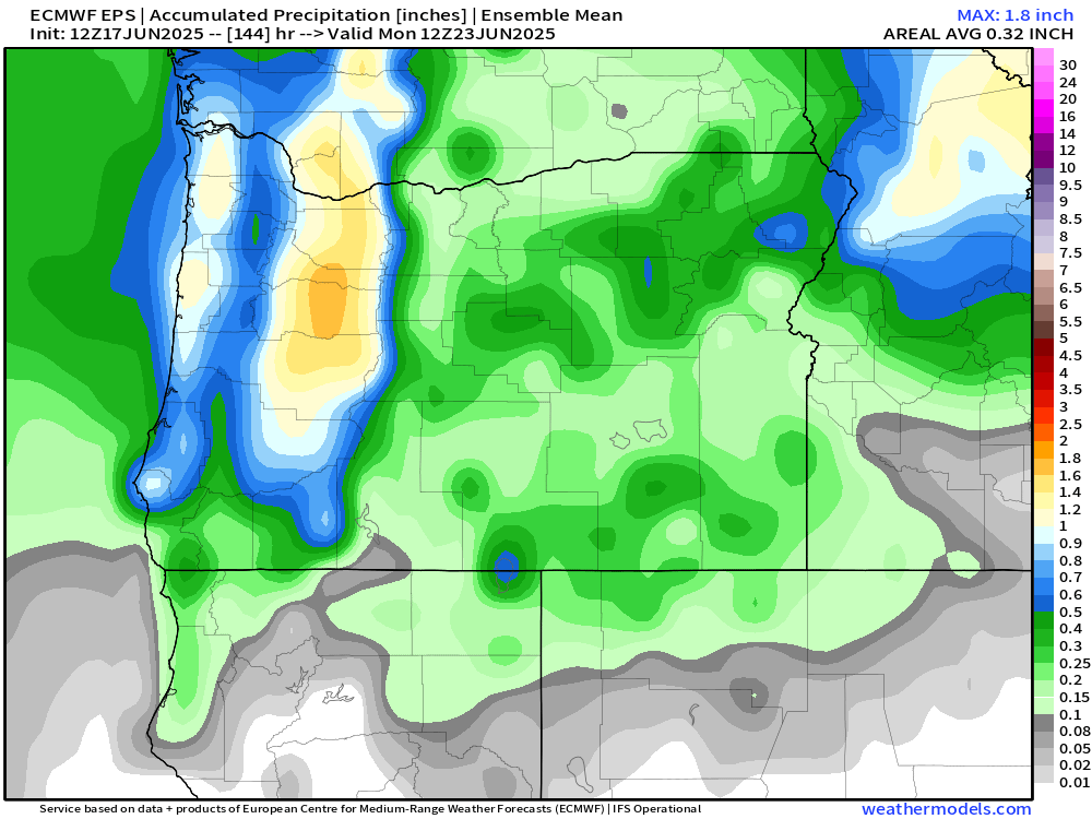
Rain totals look to range from half an inch to just over an inch of rain here in the Willamette Valley. This will bring much needed precipitation to our region!
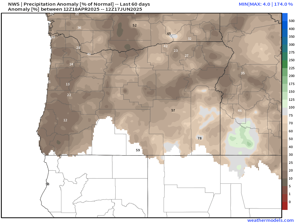
Aside from the first week of April, we have been unusually dry this spring. The few “rainy” days we have seen the past 8 weeks have not produced more than a third of an inch on any given day. The map below shows percent of normal precipitation locations have picked up between April 18th and June 17th. Many valley locations are running at a mere 15 to 25% of average.
We are running slightly better precipitation wise than the dry and hot spring of 2021. That year brought our most intense heatwave ever with temperatures soaring above 110° throughout the Willamette Valley. That was an awful experience. Luckily, no signs of hot weather.
As far as temperature goes, May 2025 went down in the history books as only being 0.2° above normal. For all practical purposes that’s considered average. At the moment, June is running 3.5 degrees above normal, a special thanks to the hot spell last weekend. That number will fall dramatically by this time next week due to the much cooler weather moving in.
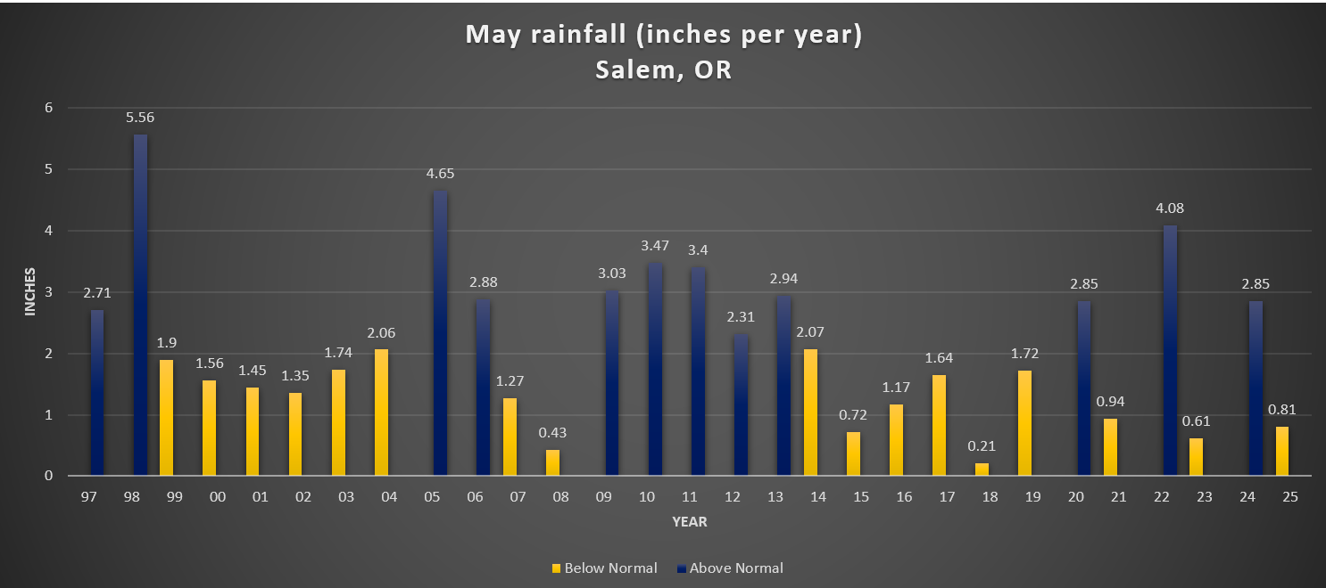
For reference, I added a chart showing total rainfall for Salem during the month of May going back to 1997.
There is no clear trend here. The only notable thing I could see was the tendency for totals to range more drastically over the past several years, but in the grand scheme of things, several years is hardly a trend.
We’ll see where we end up for rainfall in June. For now enjoy the continued dry weather, and keep in mind that Friday through Sunday will be generally wet.
The Cascades
Planning on hiking or camping up high? Well, plan on some snowfall Friday night through Saturday night. Snow levels will dip down low enough for the volcano summits/peaks to pick up several inches of snow. Timberline, the tops of the sisters, Jefferson Park, Crater Lake, and any other peaks above roughly 5500 feet could see snow this weekend. Keep this in mind. Spots along the PCT (Pacific Crest Trail) could also see snowfall impacting hikers and backpackers this weekend. By Sunday afternoon the summer sun returns and the snow up there will quickly begin melting off again.
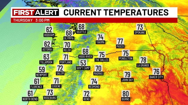
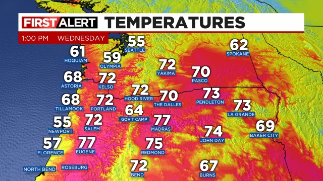
Enjoy, but don’t bee fooled by the beautiful and warm sunny weather. Thunderstorms will become quite numerous at some point later this afternoon through the evening hours. Current temps across the region show the very warm atmosphere which is a prime ingredient for storms in this type of setup.
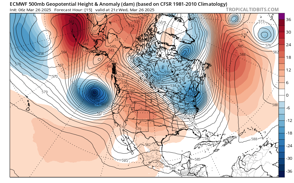
Lots of 70s out there and temperatures are still climbing. Meanwhile, 18,000 feet above us, a “bowling ball” of cold air, strong winds, and precipitation is heading towards us from the southwest. You can see it represented fairly well on this chart below:
The satellite image from early this afternoon shows this well with Salem (where the red arrow is pointing to) is firmly in the sunny and warm sector ahead of the cold front which is moving up as indicated by the blue arrow.
The cold front sweeps northeast later this afternoon and evening sparking numerous thunderstorms and downpours along it. Some of the storms could be severe which is extremely rare for our area. Large hail, damaging wind gusts of 55mph or higher, heavy rain, and dangerous lightning are all possible with the storms. Not every location will see such strong or severe storms, but everyone will see at least a period of very gusty winds (40mph or higher, and some intense downpours as the front moves through and temperatures drop nearly 20 degrees this evening!! Truly some wild and possibly dangerous weather for some of us between now and 8pm tonight.
The main message is be prepared for conditions to go downhill quickly when these storms do fire up and make their way up the valley, and don’t let the calm weather now fool you. Power outages, ponding of water, and downed trees are expected in at least some areas later today with the stronger storms.
Rainy and at times windy weather will continue on and off through Friday before we dry back out for the weekend.
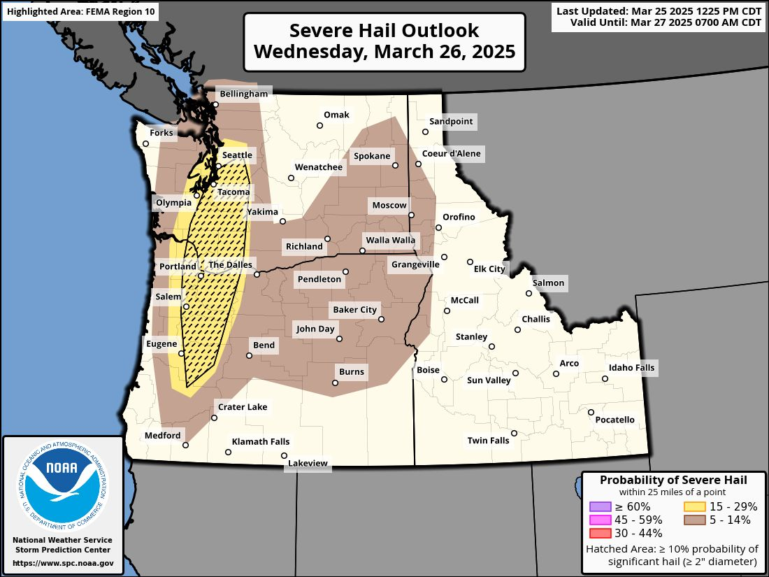
We have a rare threat for strong to severe thunderstorms for Wednesday afternoon. Thunderstorms around here are hard to predict and pinpoint, but plan on storms possibly effecting your daily plans tomorrow (Wednesday) with widespread showers/downpours by late afternoon and early evening.
All the ingredients are coming together to create a very unstable atmosphere Wednesday afternoon as a cold front pushes through what should be a fairly mild and humid environment. The biggest threats with this particular setup would be of course lightning (cloud to ground), but also very strong gusty winds (gusts could exceed 50mph with some of the storms), and large hail. I won’t make predictions for how large the hail will be, but I’ve never seen Salem get placed into the severe Hail Outlook by NOAA, so there must be something to that.
I don’t have much experience forecasting severe thunderstorms since we hardly ever get storms here, but I’m passing along what I’ve seen, and the setup does look as though it could produce intense storms with large hail. I suppose if you have the option, I would pull the car into the garage for the afternoon. Might force some of us to clean out our garages Wednesday morning making for a win win situation…. 😉 🙂
North and east of Salem stand the highest probability for storms (especially stronger storm cells), but anyone roughly from the Coast Range eastward could get hit by a thunderstorm.
Thursday will be windy with periods of rain and additional showers, and Friday looks like a soaker as well.
Saturday looks mostly dry with just a slight chance for an isolated shower, but overall a good day for outdoor activities, and Sunday looks dry until the evening when rain again returns to the picture.
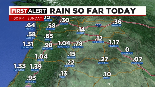
Time for a storm and forecast update. The rain portion of the forecast is working out very well. Salem officially picked up 0.84″ of rain Saturday. So far today we are now over an inch and counting. Here are the Sunday rainfall totals as of 4pm.
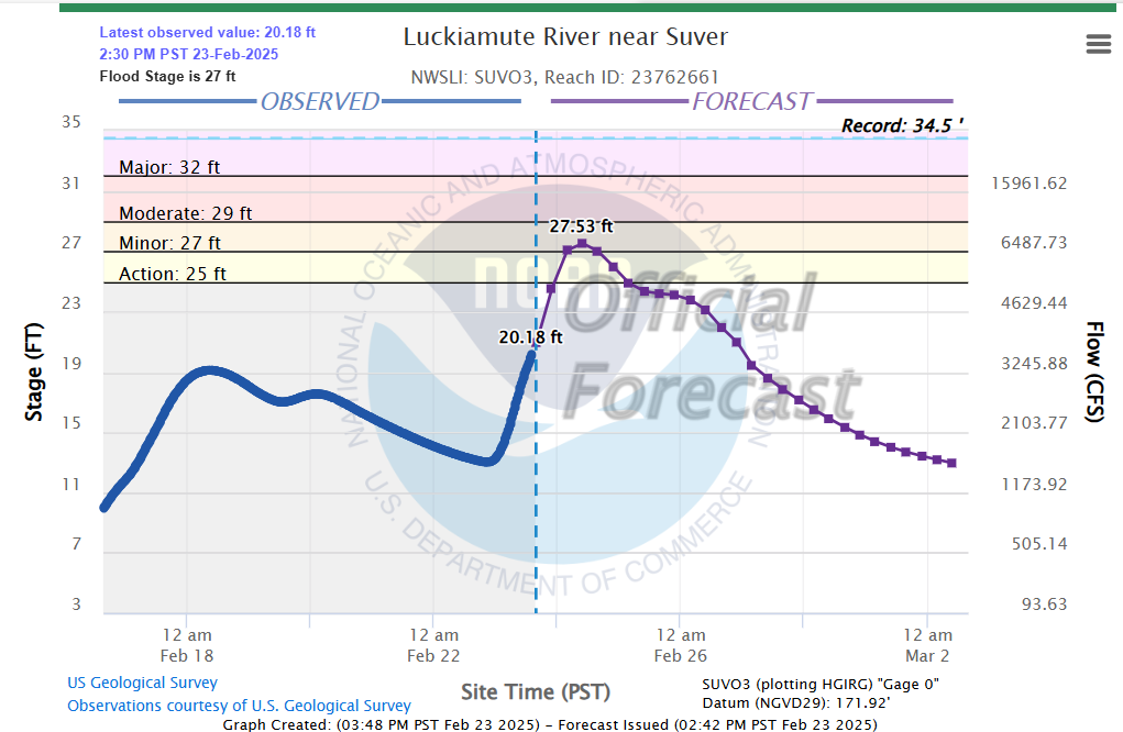
Heavy rain came down over a large swath of the central Willamette Valley earlier this afternoon driving up creek levels and causing a few isolated spots of ponding. The Luckiamute River is just one example showing the cause and effect of all that rain.
Other rivers and creeks have also shown sharp rises today. Mill Creek in Salem is currently below flood stage, but it showed a quick jump in its level today as a result of the rain. Looks like it rose almost 2 feet since 10pm last night! No major flooding is expected, and the break in the rain will help ease those creeks some.
Expect just a few scattered showers at most over the next 12 hours as we enjoy a break in the steady rain. The next batch of rain arrives around 4am early Monday morning and will last for a few hours before ending mid morning leaving us with sunbreaks and a very unstable atmosphere tomorrow afternoon.
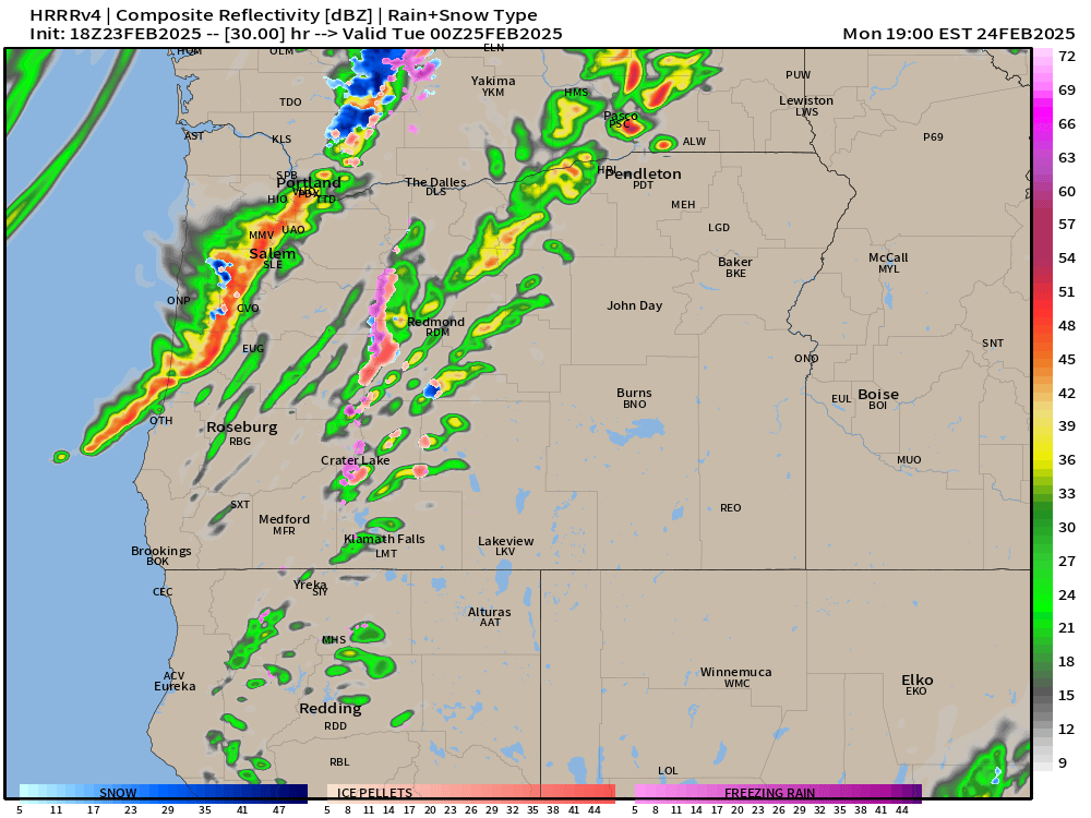
Monday afternoon through Tuesday morning
Wild weather will be on tap during this time frame. Heavy downpours, strong gusty winds, and even thunderstorms are possible during Monday afternoon. Dynamics are in place which could lead to some strong thunderstorms -something which is pretty rare for our region. This estimated radar image for 4pm Monday afternoon shows an intense line of showers and storms rolling across the valley. These storms would bring very heavy rain, gusty winds, and of course the possibility for lightning and thunder.
The map above is not gospel truth, but it does give us a general idea of what Monday afternoon might look like by showing the potential for storms.
Additional showers and periods of rain fall during the night Monday through Tuesday morning. Tuesday afternoon should be fairly sunny with only a couple isolated showers leftover.
As far as the wind goes, I’m still expecting the strongest winds to take place Monday afternoon through early Tuesday morning. Wind gusts since Saturday have generally underperformed with most locations in the valley seeing nothing higher than 35mph, which is still breezy, but not strong enough to cause lots of problems.
The storm coming in Monday is a totally different setup. This final round of wind will be a result of a low pressure racing northeast off our coastline. The path the storm is taking is ideal for bringing strong gusty winds to the valley. I’m confident we will see widespread gusts of 40 to 50mph resulting in scattered power outages across the valley.
Tuesday afternoon kicks off a several day stretch of calm and mild weather which should last through Friday.