A quick weekend and Spring Break update

This week has gone pretty much as planned with showers today and continuing through tomorrow. Here’s a quick look at what you can expect now through Sunday.

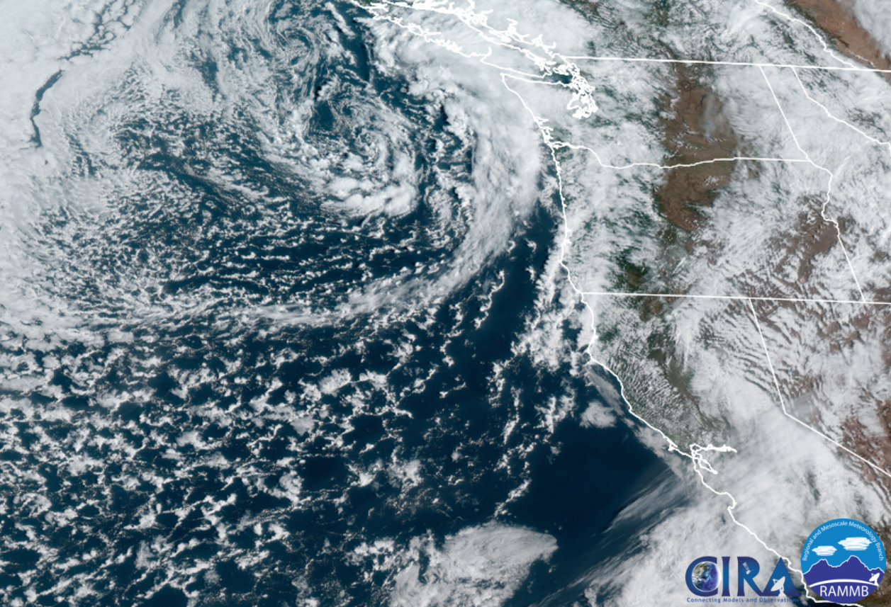
  • Today & Saturday will both be active days around here. Sunbreaks, lot of available moisture, and very cold air aloft (up in the atmosphere) will combine to give us a threat of a few thundershowers, downpours, and hail. Some of the showers could contain a lot of hail, so be careful if you are caught out on the road when one of these showers hits. This satellite pic from around 10:45AM shows a nice swirl of clouds and bands of heavy showers rotating towards Oregon. This will be our weather pattern through Saturday evening.
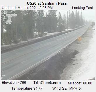
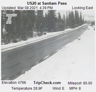
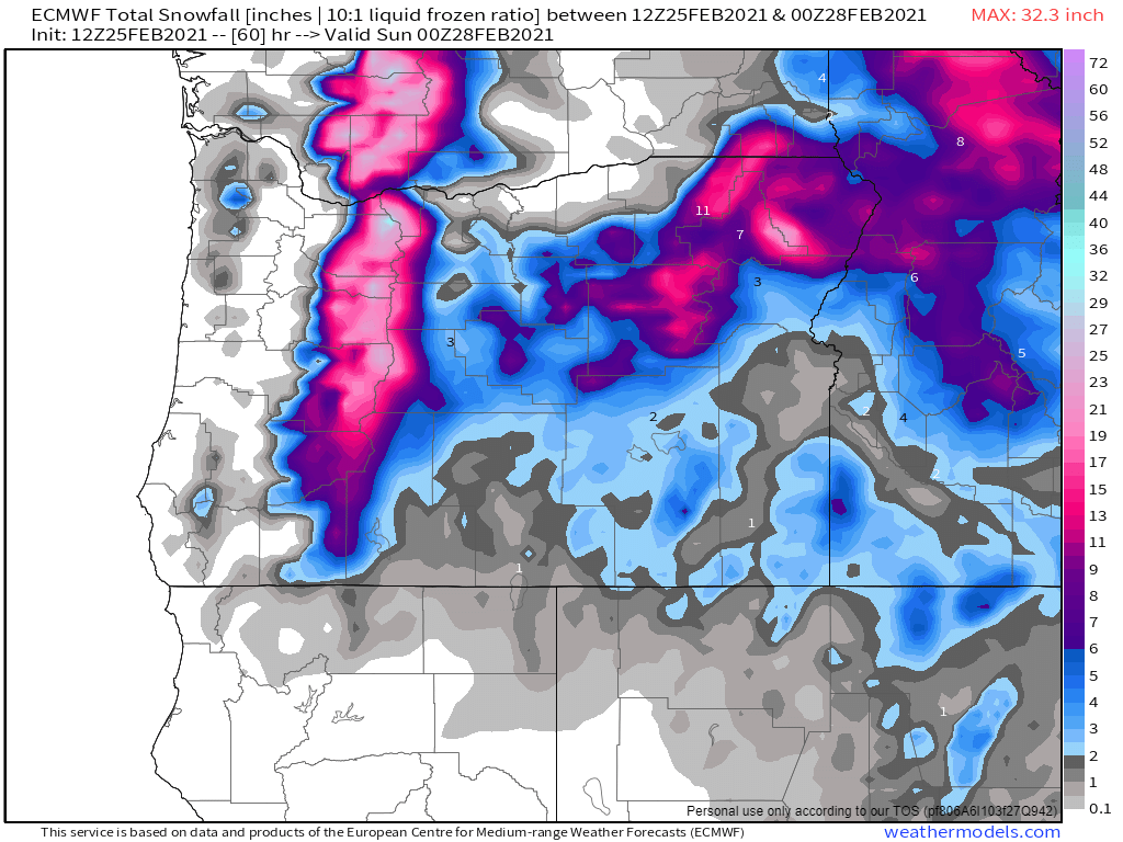
  • Snow levels are around 2000 – 2500′ with 5 to 10 inches of new snow falling in the Cascades through Saturday night. Expect snowy passes Monday, Wednesday and Thursday of Spring break.
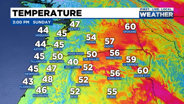
  • Sunday will be the driest day this weekend with rain moving in sometime after roughly 3PM.

Spring Break

What everyone wants to know is which days are going to be nice and dry for outdoor activities, and which days are going to be wet. Fortunately, this guy right here has you covered! 😉

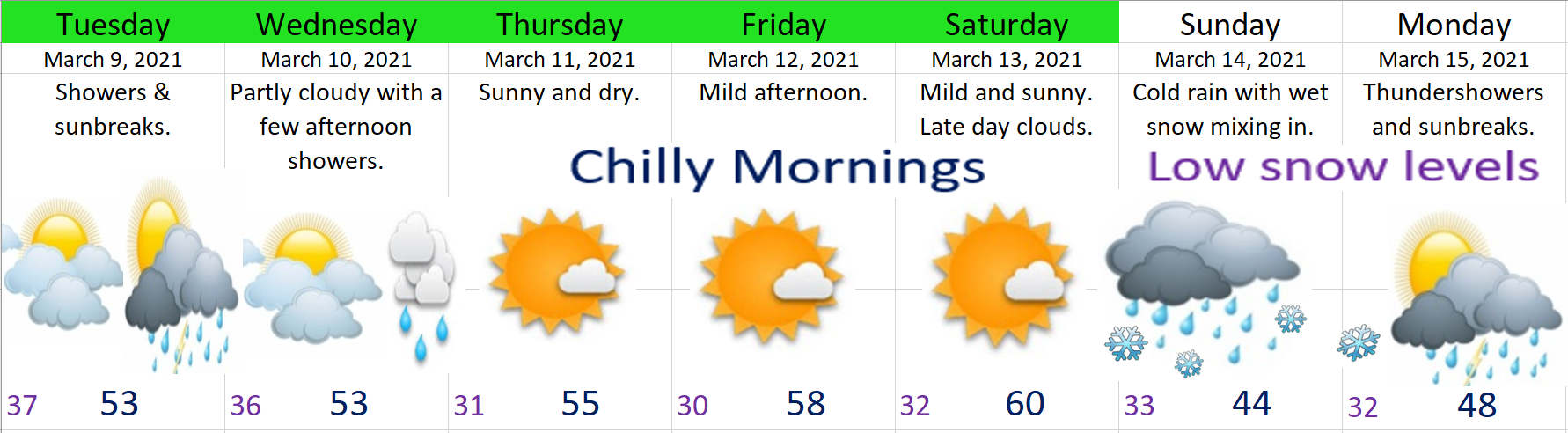
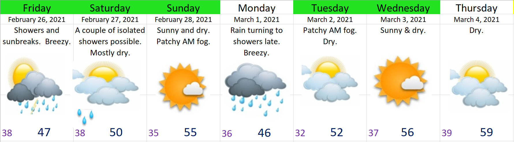
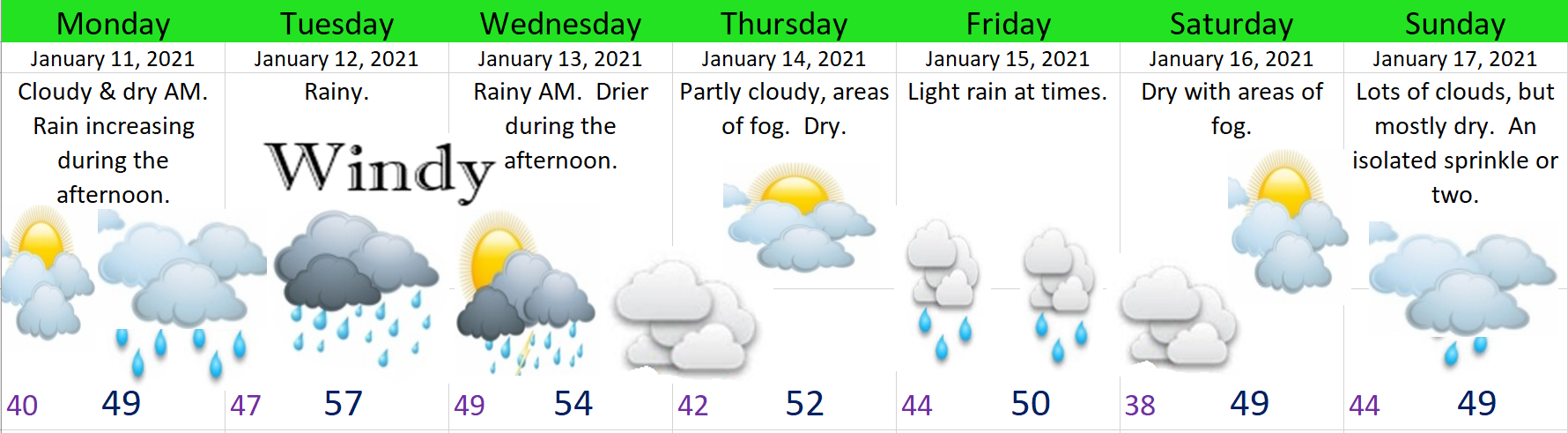
1.) Our mostly wet days will be Monday, Wednesday, and Thursday. These days will all have dry times mixed in between the showers, but overall expect these days to be wet.

2.) Now for the dry days! Tuesday, Friday, and next Saturday, & Sunday all look nice and dry!!! 🙂 🙂 So we should finally see a completely dry weekend around here!

There you have it. Stay safe, try to stay dry, and have fun out there!

Storm update

Quick update on this Sunday afternoon.

The forecast is still on track with a cold front moving through right now. Salem recorded a temp of 50° at 1PM and that will end up being our high for the day as colder air is already moving in from the northwest. You can see where temps stand as of 3PM with the coast being colder than central Oregon at the moment.

Snow levels drop down to 1000′ – maybe a little bit lower on the east side of the valley tonight as even colder air works its way down from the NW. Scenarios like this occasionally lead to “lower than expected” snow levels in east valley & foothill locations. Any lower than expected snowfall will be very short lived and minor, but don’t be shocked if you see a few slushy flakes mixed in tonight with the showers.

Monday should be a mostly dry day with just a few afternoon showers of rain, hail, and maybe some graupel. Graupel is really nothing more than a mixture of snow and ice pellets. Expect some of the showers to be rather heavy.

Nice dry and sunny weather looks like a lock for Tuesday and Wednesday before rain returns on Thursday through much of next weekend.

The Cascades

Passes turn snowy within the next hour and will stay fairly snowy through Monday morning with 3 to 6 inches of new snow. Santiam Pass has cooled 6 degrees within the last hour!

By Monday afternoon roads should be bare/wet as the increased energy from the March sun warms pavement up nicely this time of year.

Have a fantastic rest of your Sunday!!

Typical March weather….

Checking out the radar this afternoon you can see a few scattered showers around with lots of dry breaks in between. Showers here and there, but the majority of the day has been dry. Expect basically the same exact thing both Tuesday and Wednesday.

Extended Forecast

Highlights

Thursday – Saturday: Totally Dry. Cool nights and mornings with lows dipping to freezing each night, but mild and sunny afternoons.

Sunday: A powerful and dynamic cold front moves in lowering snow levels close to the valley floor. I’ll keep an eye on this storm, but for now plan on valley rain with snow in the mountains above 1000′. This system will leave behind some very chilly showers on Monday with highs struggling to reach 50°.

The Cascades

This time of year the roads generally stay clear of snow and ice during the daylight hours and this week is no exception. The road cam at the top of Santiam Pass shows this well. Temps below freezing with occasional snow falling; however, the road surfaces themselves are above freezing thanks to the increased energy output of the March sun.

I expect several more inches of new snow now through Wednesday night keeping a fresh layer of snow up there.

Sunny and mild Thursday – Saturday, but big time snowfall coming for Sunday and Monday with the cold storm system posed to move in.

There you have it! Take care and stay safe.

End of month forecast

February 2021 is coming to a close and March is just around the corner. Here’s how the next 7 days are looking:

HIGHLIGHTS

1.) Friday: Cool and breezy with rain and hail showers, sunbreaks.

2.) Saturday morning through Sunday night will be dry. I can’t help but feel like someone was praying really hard for a dry weekend, because that is exactly what we have on tap. Temperatures are going to be chilly in the morning hours; however, the late February sun should help keep things more reasonable during the day.

3.) I’m calling for rain for Monday with breezy winds of 20 to 30mph – a stormy day. Some of the weather models have this day totally dry which is why I’m not as confident about this forecast, but for now plan on it being a wet day.

4.) Tue – Fri should be dry. Watching for the chance of rain on Friday, but other than that, most of the work week will be dry and mostly sunny! I wouldn’t be surprised if some locations in the valley hit 60 this week either Thursday or Friday. Yes, spring will be trying to make an appearance this week. 🙂

The Cascades

Up in the Cascades snow levels will hover around 1500 – 2000′ with tons of fresh snow up there over the next 36 hours. This chart is showing 1 to 2 feet of new snow now through Saturday afternoon depending on elevation. This is in addition to the several inches of snow which fell all day long today. It’s going to be quite the snowstorm up in the mountains as winds will be gusting 25 to 35mph creating near whiteout conditions at times on Friday. Not a good time to travel up there. Saturday and Sunday will be much better, especially after around noon on Saturday.

Have a fantastic weekend and take care!!!

Computer models, and much colder weather ahead!

I have to tell you there has been a whole lot of confusion on the weather models over the past week. By the way, when I say weather or computer models I’m not talking about fancy dressed up computers walking down a catwalk haha. I’m talking about a set of computers that forecast or model out potential weather outcomes two to four times a day (depending on the model). Getting back on track, I have noticed a shift in the models over the past couple of days showing some much colder, possibly very cold arctic air coming right down into Oregon next week. In my previous two updates you may recall me using an awful lot of yellow highlighting on the extended forecast indicating a high amount of uncertainty. Over the past week or so the forecasts have been going back and fourth between really cold weather and more mild/spring like weather. As of this afternoon there seems to be fairly solid agreement that a much colder airmass is headed for Oregon.

It’s too soon for very many details which is why I still have yellow highlighting for the last two days. The main message is much colder weather is on the way, and with this cold air will come an increased chance for valley snow. I sense many more updates in the coming week or two…. 😉

Here’s a few details and highlights for this coming week

1.) Saturday through Monday will feature a whole lot of clouds, but not a lot of precip. Basically a few showers each day with a couple peaks of sunshine here and there. We will also be getting progressively cooler each day with Saturday’s highs in the upper 40s. Sunday’s high temps will be in the mid 40s, and by Monday highs will drop down to the low to mid 40s.

2.) Tuesday through next weekend will no doubt be cold with lows possibly getting as cold as the upper teens. Brrrr!!! Regarding the chance for snow, there is still a lot up in the air right now. At this time I’m sticking with a mostly dry forecast, but don’t be surprised if a lot more snowflakes start showing up in the forecast. I’m watching Thursday through next weekend in particular as we could see a “classic” snowstorm setup with cold air in place and a storm system moving in to our south. In the past it is this setup which has typically produced our biggest snowstorms. Again, all possibilities for now, but it’s something I’m watching very closely!

THE CASCADES

Currently our snowpack is below normal for this time of year, and I don’t expect anything more than about 4 to 6 inches of new snow now through Monday which is not a whole lot. With that said, there’s still plenty of snow for skiing, snowboarding, snowshoeing, or whatever it is you do in the snow up there. 😉 As of this afternoon Hoodoo has a base of 67 inches which is still a decent amount of snow.

Of course, if a big storm does come in with the cold air late next week bringing snow to the valley, then I would imagine the mountains would also score some really big snow totals.

Happy Friday!!!!!

Progressing nicely.

Well, no major surprises yesterday. As forecasted, a very cold rain fell through most of the Sunday with snow mixing in above 500 – 1000 feet with plenty of snow falling in both the Cascades and the Coast Range. The airmass outside this morning is chilly. Check out area temps as of 8AM.

There are pretty clear signals that we will continue to stay under the influence of cool airmasses for at least the next 7 days. I see several more chances for snow coming up this week as well; although, at this time none of them are looking real solid. Here’s my latest thoughts.

The rest of today/tonight: We could see a brief snow shower, but do not expect accumulation. We have a better chance of seeing ice pellets or even hail accumulate today than we do with snow, and even that chance is minimal.

Tuesday: It really comes down to how cold we get tonight. If we can get down to 30° or colder, then I believe we have a decent shot at snow. The problem is we have no real source of cold air to draw from, and we don’t have arctic air in place either like we have had for past snowstorms. The precipitation is arriving during the daytime on Tuesday which is why it’s crucial (if you want snow) that we start the day off cold. I’m still leaning towards no accumulating snow except maybe briefly in the highest hills around town (west and south Salem). Could be a situation where we see lots of snow falling through the air, but not sticking here in town. I’ll have an update tonight and possibly again tomorrow morning as we get closer.

Wed & Thu: Low snow levels continue. Not expecting much (if anything) during this time either, but will keep an eye on things in case changes pop up.

Fri: Will likely end up being a similar to what we are seeing today, but with maybe a little more precip, and slightly cooler temps. Those two changes equal a better shot at seeing some light dustings of snow around town.

Sun: Another cold system comes in bringing low snow levels again… This is a long ways off, so not too concerned about it yet, but you get the idea – low snow levels are here to stay for awhile which means lots of updates and things to keep a close watch on.

Finally, it should go without saying, but both the Coast Range and the Cascades will be getting lots and lots of snow in this cool & damp pattern. Keep this in mind when traveling as almost every highway in the state outside of the Willamette Valley will be prone to snowfall most of this coming week.

Take care and happy Monday!!

Wet

Good and happy Monday morning!!!! 11 days into the month and January is running well above normal in the precip department. We have had several wet storm systems and we have a couple more coming up this week. Take a look at the next 7 days

The heaviest rain will fall during the nighttime hours tonight through tomorrow morning and again the same story Tuesday night. Winds will also be quite gusty Tuesday and Wednesday with gusts 35 to 45mph (maybe a gust to 50 here and there Tuesday night). I suspect 2 – 3 inches fall between now and Wednesday evening here in the valley. This will be a warm rain event, so no snow in the mountains unfortunately.

The only other weather event happening over the next 8 days will be some light rain falling Friday; otherwise, the rest of the next several days should be basically dry and quiet through at least next Monday or Tuesday.

The Coast

The coast should see winds up to 65mph Tuesday and Wednesday along with 3 to 4 inches of rain, and waves topping out 30 to 40 feet! It’s going to be an extremely stormy couple of days at the good ol’ Oregon coast.

There you have it! Watch for localized flooding over the next few days with this heavy rain, and I wouldn’t be shocked if a few people lost power with the wind Tuesday night and Wednesday.

Looking further ahead, it appears as though the second half of January might turn a bit more exciting and maybe a bit cooler too ( a nice little tease hehe), but for now the only highlight worth mentioning are these couple of very wet & windy storms. Take care!!