Extended forecast

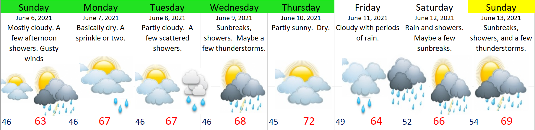
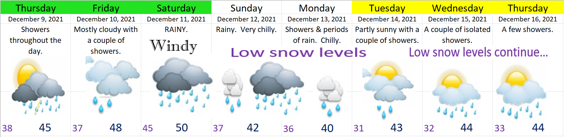
There are multiple items peaking my interest this evening on the weather models. I have forecast details below including an update on the Cascades. Here’s our 7 day forecast for all of us visual people first. 😉

Details and Highlights

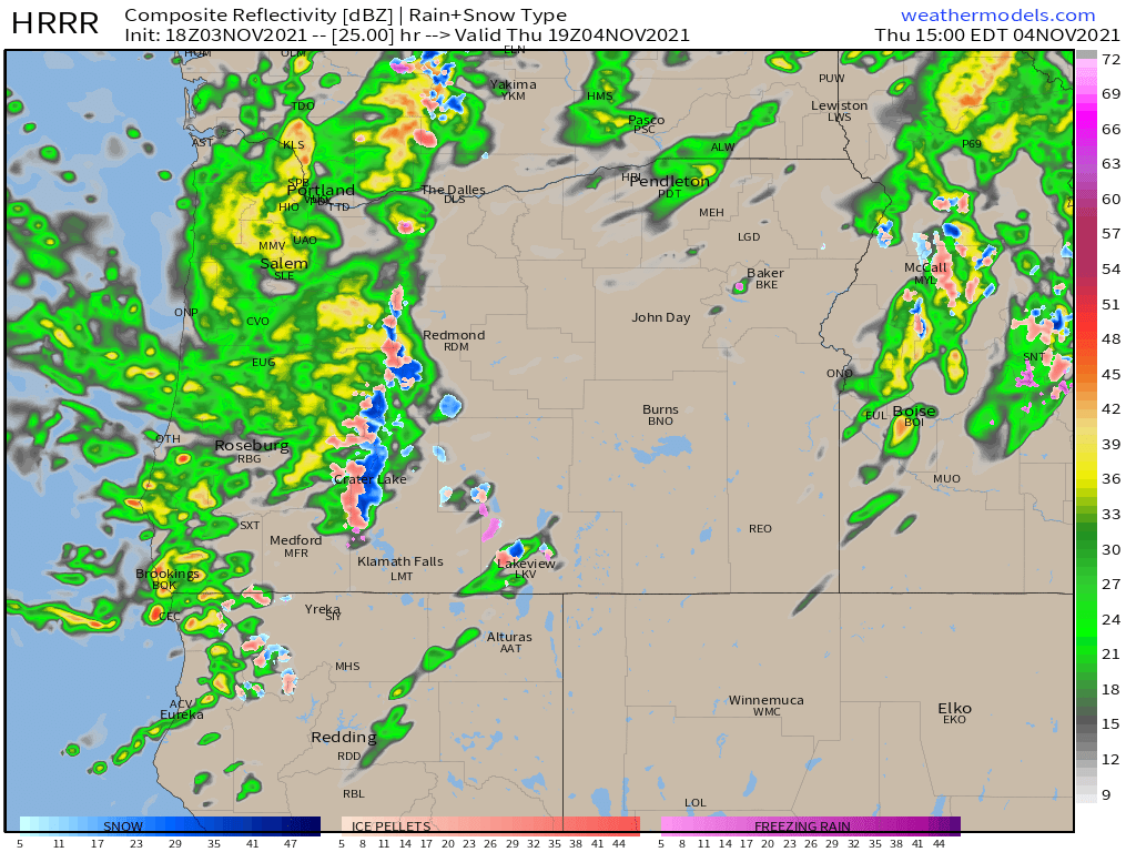
1.) Chilly showers tonight through Friday evening with snow levels dipping close to 1000′. Could see some ice pellets and or wet snow mixing in with the heavier showers.

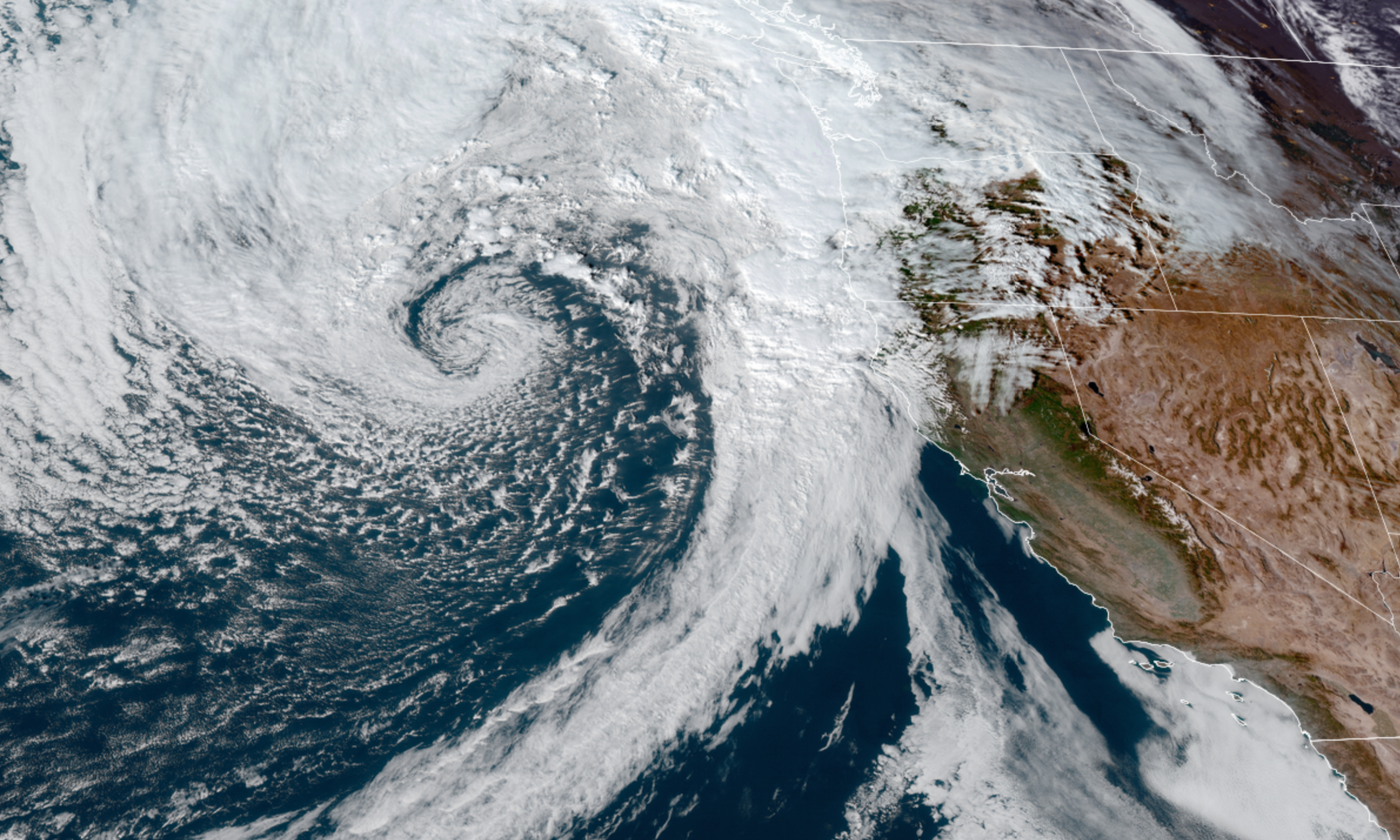
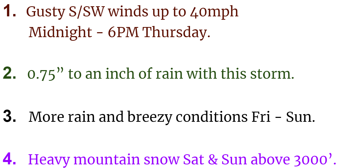
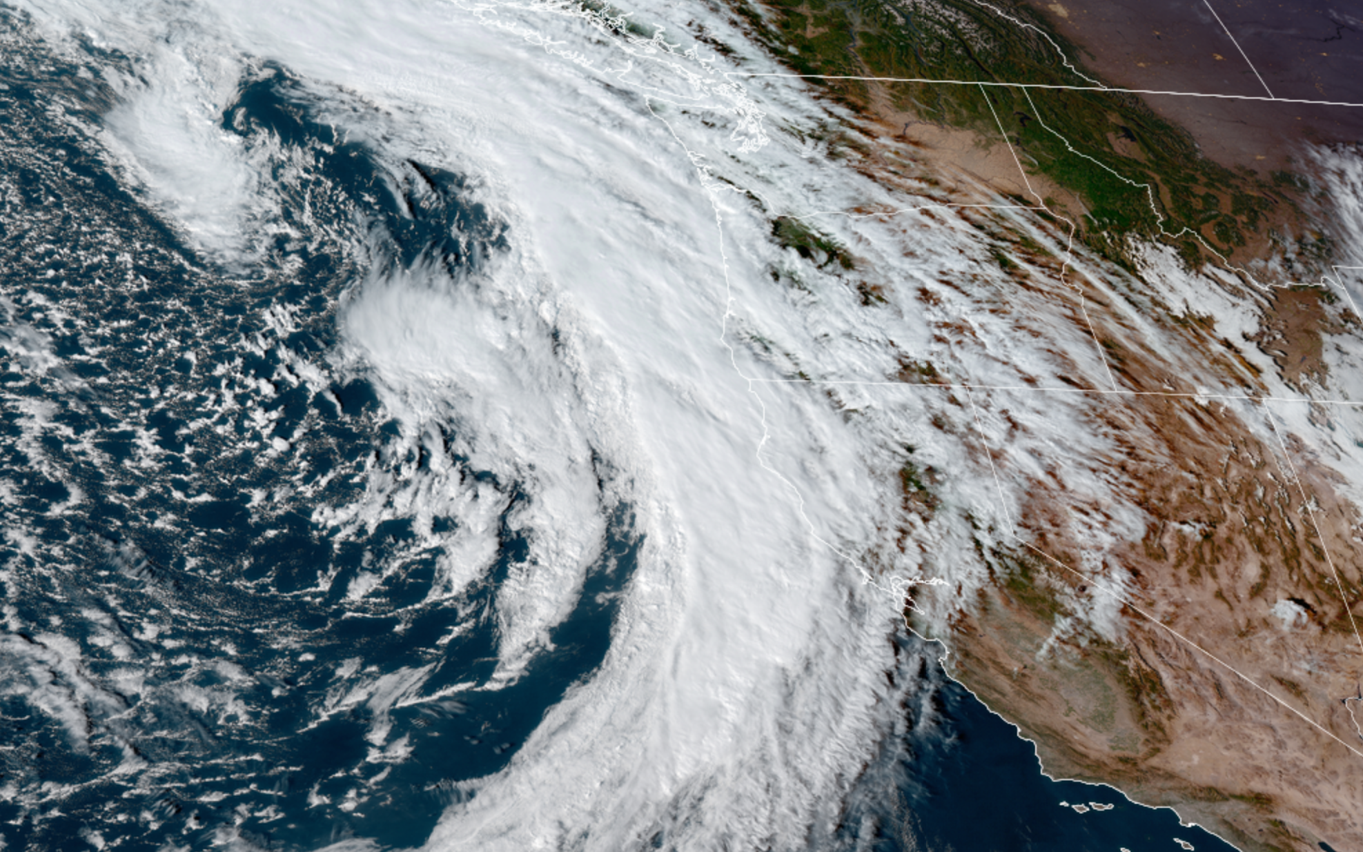
2.) A powerful storm is set to move in on Saturday. Saturday will be a complete washout all day long. Winds will be strong during the early morning hours with gusts around 40 to 45mph. This storm will have quite the impact across the region with even stronger winds on the coast Friday night and Saturday morning (gusts up to 65mph), plus heavy mountain snow, and heavy rain in the lowlands. Expect some really terrible travel conditions this weekend.

3.) Very low snow levels Monday – Thursday of next week with several storm systems rotating through the region all while cool air is in place. What is certain is the Cascades are going to get hammered with a ton of snow. I’m fairly confident the Coast Range will see a quite a bit of snow as well.

4.) Notice I don’t have any snowflakes on the forecast yet. Right now I’m thinking it will be a little too “warm” for snow next week with the snow level staying above 1000′, but watch for new updates in case anything changes.

5.) Watch for black ice on roads this coming week as we flirt with below freezing temperatures, especially if we have some clearing during the nights.

The Cascades

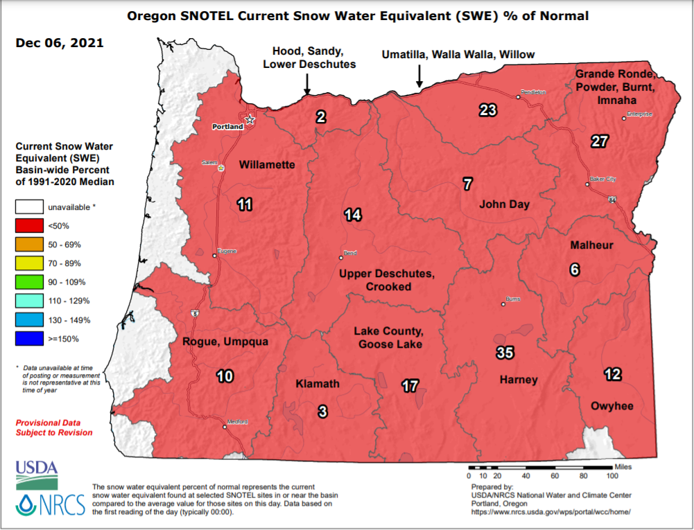
There was absolutely no snow at Hoodoo Tuesday afternoon. Mount Hood had a little in the upper most elevations, but all of this is just now beginning to change. First off, checkout just how awful our current snowpack is. As of Dec 6th the entire state was running way behind in the snow department. Fortunately, it is very early in the winter season, and as I mentioned things are changing.

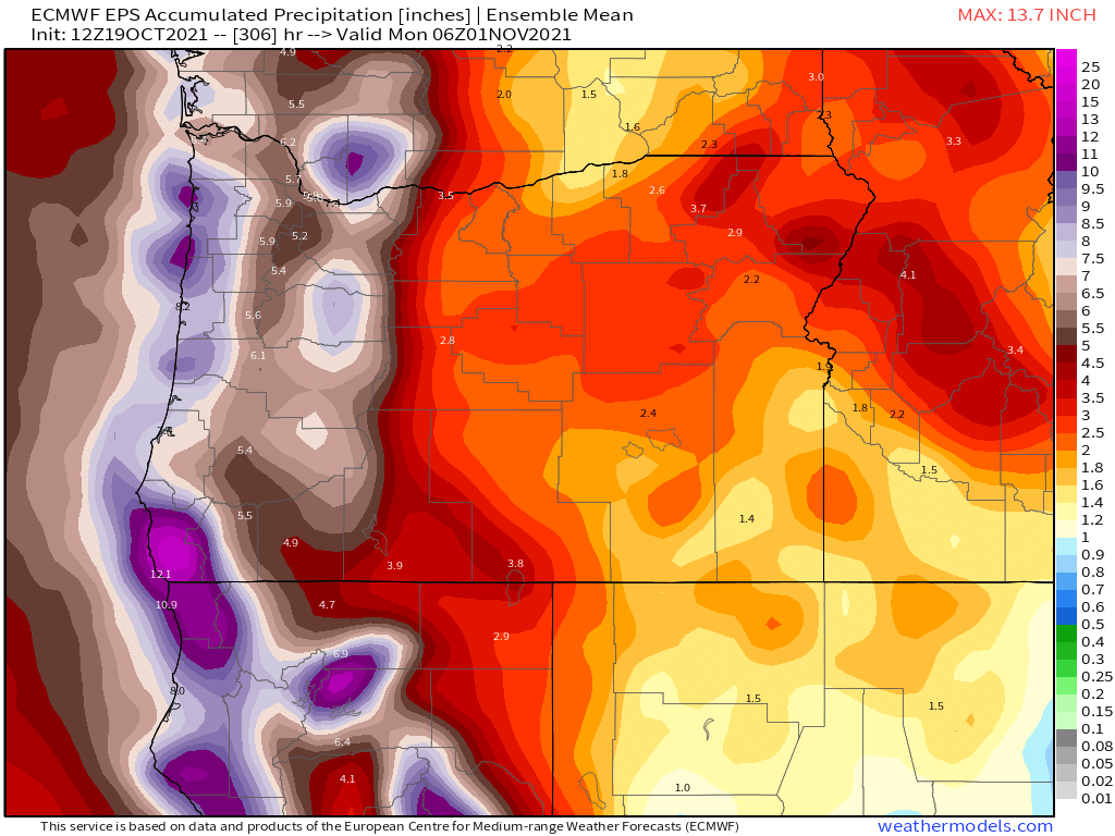
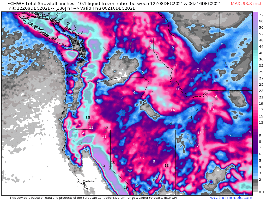
Now look at how much snow is expected to fall between now and Monday night.

Some 40 – 50 inches of snow up on the mountains in only 5 days!! That is a significant amount of snow in a fairly short timeframe. Travel across the mountain passes looks terrible this weekend, so use extreme caution if you find yourself headed that way.

This parade of storms will bring much needed rain to both Oregon and California – even southern California. Meanwhile, the Sierra Nevada will see feet and feet of snow along with many of the mountain ranges out west. Overall a wonderful pattern for building the snowpack, restoring groundwater, and replenishing the drought stricken regions out here in the western US. This map shows snowfall for the entire west coast now through Wednesday.

The downside to this will be the adverse impacts on travel. I suspect we will hear of highway closures in the coming week as heavy snow blankets the mountain passes across the region. This will effect travel and the delivery of goods – another reason I am all about staying prepared with food and supplies at home. Okay, have a great evening, and keep an eye out for more updates as the weather is looking to stay active!

Extremely mild and November 2021 recap

The second half of October and the first half of November were both quite stormy and active with several small to moderate wind events, plenty of rain, and mountain snow. Since then it has basically been a blowtorch around here. November 2021 ended up being 3.5° above normal which is fairly significant. We still managed to dip below freezing once on the 21st with a low of 30°, but overall it was quite mild with 9 days reaching at least 60°! In the precip category we came up a little bit short despite the very rainy and wet start to the month. 5.50″ was our grand total for the month which is 92% of the monthly average.

November is actually one of the months which became slightly drier when the new averages were updated this past year. Between 1980 and 2010 the normal rainfall for Salem during the month of November was 6.5″. When the 1980s were dropped and the 2010s were added, our average rainfall for November dropped by a little more than half an inch down to 5.95″. Meanwhile, both March and October have turned wetter over the past decade. Interesting don’t you think? The maps below show the changes in average precip for each of these months.

Total Salem rainfall for November going back to 1990.

1995, 1999, 2008, and 2016 all had really mild Novembers as well with temps very similar to what we have seen this year. All 4 of these years were also La Nina winters, and 3 of the 4 years listed ended up delivering at least one good snowstorm here in Salem. I’m sure some of you remember all the snow we had before Christmas in 2008, and then the winter of 2016/2017 had several snow events too, so a warm November does not at all mean a warm winter. It doesn’t guarantee a cold one either, but don’t be too worried about the lack of cold or mountain snow just yet. In fact weather maps are indicating this may be the last week of mild weather for quite some time, so get out there and enjoy it! 🙂

Quick forecast and look ahead

1.) Mild weather continues through Sunday; although today will likely be the last 60 degree day – finally…

2.) A few sprinkles are possible both Thursday and Saturday, but honestly it won’t amount to hardly anything.

3.) The nice weather ends Monday as a significant storm system rolls in bringing a good amount of rain. This storm will be the first of several storms bringing multiple rounds of showers, rain, and mountain snow for the rest of next week.

Stormy fall weather

We have a nice fall like storm approaching our coastline tonight, and an overall very active and exciting weather pattern shaping up for the next several days. Here’s a satellite image from late this afternoon showing the looming storm.

Impacts here in the mid Willamette Valley

Below is an estimated radar image for around noon tomorrow showing the heavy showers expected on Thursday.

EXTENDED FORECAST

Thursday: Quite stormy with the gusty winds and numerous showers.

Friday: Showers. Dry and maybe even partly sunny near the end of the day. Will cool off quickly once the sun goes down.

Saturday: Much cooler with steady rainfall. Breezy afternoon.

Monday: This day could end up being mostly dry.

Tuesday: More rain and wind arrives and will likely last through Wed also.

I’ve got a nice little October recap in the works. Looks to stay active for awhile, so anticipate more updates in the coming days.

Take care, be extra kind, and stay safe!!

Stormy week ahead

I have a fun new chart to show you all. This chart below is really good at conveying the big picture up to two weeks out with each horizontal line showing a single possible outcome. Time on this chart goes from left to right and it shows 24 hour rainfall totals (measured in inches) ending every 12 hours which means there is some overlap with these totals.

What I look for on charts like this one are patterns and trends – not details. So in this case the concentrated number of predictions showing heavier rainfall around the 22nd and again near the 28th of October provide me with a high level of confidence some sort of big rainstorm is heading our way both those days. Another use of these maps is just looking at the probability for rainfall on any given day. For example, from looking at all of these possible outcomes, it seems extremely clear to me that today will be the last completely dry day until at least the 30th with many of the predictions showing rainfall every single day for the next 11 days.

We are heading into a very stormy and wet weather pattern. Right in line with what we would expect during a La Nina. Between now and the end of the month we could easily see over 5 inches of rain! Check out this total rainfall map ending close to midnight on Oct 31st.

Again, the message seems very clear to me which is very wet times are heading our way. Here’s a satellite image of tomorrow’s storm heading our way.

Highlights

Two other things to really watch for with these storms are: number one, the high surf and big waves at the coast. These storms are capable of producing some really big waves. Great for storm watching, but be careful if you head out there.

The other concern I have is for high winds and the increased potential for power outages in the coming days as strong winds develop with some of these storm systems. In fact, we could see fairly gusty winds Wednesday with this first storm system. Winds will likely gust 30 to maybe 40mph tomorrow morning. Nothing too crazy is being predicted for the moment, but this pattern will bring the windiest weather we have seen since January.

We also have a chance for a few thunderstorms Wednesday.

Thursday will start out mostly or even completely dry and could stay dry until the late afternoon before the next storm rolls in.

Expect both the weekend and much of next week to be stormy and quite wet.

Stay safe!

Extended Forecast

1.69 inches of rain fell in Salem between Friday and Tuesday making that the wettest stretch of days we have seen since the ice storm back in February! Goes to show just how dry this spring has been. It was good to see so much rain fall across the region as we desperately needed it.

Looking ahead I see lots of warm and even very hot weather on tap with highs in the 80s both Friday and Saturday.

Highs soar into the 90s for the second time this month on Sun – Tue. Monday will be the hottest day with highs reaching the upper 90s and lows only down into the mid 60s. YIKES!!!!

Very warm weather continues through most of next week as well with one possible twist. I’m watching for a chance of thunderstorms probably just along and east of the Cascades on Tuesday, but this could change as it’s still several days away. Definitely something I’m keeping an eye on.

Enjoy the hot weather, and stay safe and cool.

Changes in the forecast

First off, today has been a great example of what “a mostly dry day” looks like. In my previous forecast I mentioned we would likely see some drizzle or a few sprinkles and to not cancel your outdoor plans, and nothing more than a few sprinkles is exactly what has happened today. Nice to see a forecast come through 🙂

Moving on I’ve noticed some really good trends in the forecast lately. Just two days ago it was looking like sprinkles would be about the best we could hope for in the coming week, but now it appears as though we will pick up much more than that.

Extended Forecast

Highlights

1.) Big changes in Sunday’s forecast with this storm system coming in just south enough now to clip Salem. Expect more rain further north in the Portland area while Eugene and points south should remain basically dry. Right here in Salem be on the lookout for some heavy afternoon showers along with gusty winds. Gusts over 30mph are possible. Don’t be shocked to hear some thunder with the showers either.

2.) Monday: Lots of clouds, a few sunbreaks, but really nothing more than a few sprinkles at most. Basically dry.

3.) Tuesday & Wednesday. Partly cloudy with PM showers. Showers will favor the coast, Coast Range, and the Cascades. Slight chance for a thunderstorm or two. Because the showers will be scattered in nature, there’s a chance some of you stay mostly dry these two days while others experience a brief soaking.

4.) Thursday: Partly sunny and dry. The best day of the week to be outdoors – assuming you wish to stay dry lol 😉

5.) Friday: Periods of light rain.

6.) Next weekend: Lower confidence, but as of right now, both Saturday and Sunday feature a decent chance of seeing frequent showers, and depending on the track of this system, maybe a few thunderstorms too.

Overall the forecast has trended quite a bit wetter for both tomorrow and much of next week. The map below shows the forecasted total precip now through next Sunday.

Basically if this materializes everyone here in the valley should pick up at least an inch of rain over the next 8 days with more in the mountains and along the coast. Even central and eastern Oregon should get in on the action with rain expected over there as well. This is really good news for our drought conditions, and we need it! Below is an up to date version of the map I shared a few days ago. It shows total rainfall in inches here in Salem since March 1st versus the total we should be at.

This shows we are the better part of 5 inches below normal. So yes, we do need the rain!

On a side note, one of the primary radars used to detect rain in western Oregon is down for repairs until at least Thursday. This means the little rain maps on the apps you use and some of their hour by hour forecasts may not be as accurate as usual. Just fyi and something to keep in mind. With the increase in active weather I will likely have additional updates for you in the coming days as things change.

I hope you all are having a wonderful weekend! Stay safe!

A special guest post and quick look ahead

I have a very special guest post today coming from a friend who lives all the way in New York City! She and her friend have written up a nice forecast over there highlighting what one can expect should you find yourself in that unique part of the world. 😉 Our local Salem forecast is tagged along at the bottom. ENJOY!!!!

Forecast for New York City

Saturday – a wonderful day, use best you can. Sunday…it’s for the ducks 

Cold front will start rolling into NYC on Saturday around 4am and will calm the windy conditions seen on Friday. Clear skies with a temperature in the high fifties to low 60’s. Winds ranging from 12-25 MPH. Nice day that Saturday ðŸ˜‰ We recommend using it to get outside and catching a glimpse of the rare and exotic green parrots atop the Greenwood Cemetery Arch.

If you happen to forget your sunscreen on Saturday and end up getting a ring-tail lemur sunburn on your ankles, don’t fret, because Sunday’s weather will be keeping you inside. Early Sunday morning, starting at 2am, nice conditions will start to diminish, clouds will be low, winds will be light. Heavy rain will commence at 8am with winds hitting full tilt at 11am. Wind gusts will pick up to 40 MPH. As Sunday progresses, clouds will thicken like a split-pea soup (which apparently no establishment in NYC carries despite our repeated pleas) This will cause poor visibility and rain with the temperature in the low 50’s. Fog is not out of the question folks. Rainy conditions and visibility will improve during the evening, but wind will remain, so no skirts. 

Monday the skies will be back to their old ways- a cool 55, partly cloudy, no winds. The perfect start to a week locked inside working. Looking ahead, Tuesday will be your last chance before rain picks up mid-week with the sun coming back to shine on all your beautiful, bountiful Easter eggs. 

Salem Area Forecast

Looks like NYC has a similar weather forecast to us in that today is going to be a beautiful day with highs in mid 60s and lots of sunshine.

Sunday starts off nice; however, we also make a switch to weather fit only for ducks 😉 as things go downhill in the afternoon with a very potent cold front moving in. Winds will be strong at times gusting up to 35mph and rain will be quite heavy at times. If you have outdoor plans I would aim to have them done by 1 or 2PM on Sunday with rain moving in by 4PM at the latest.

Temps drop dramatically Sunday evening with this powerful cold front. Snow levels Monday morning will be down to 1000′. Lots of snow up in the Cascades. I’m thinking like 6 – 10 new inches with this storm. Very poor driving conditions up there Sunday night through Monday with gusty winds blowing that heavy snow around a bit. Back here in the valley we will be left with a few scattered showers on Monday before drying out for much of next week with highs returning to the 60s Tue – Thu or even next Friday.

Whether you are in the Big Apple or the Cherry City 😉 enjoy the nice sunny weather while it lasts and a special thanks to my friend and her roommate for writing up their gust post!