Friday AM update

A few updates for you this fine Friday morning.  If you are in a hurry here’s the latest.

Feb 1

The biggest change has to do with Saturday being much drier than previously thought as the rain will be just about finished before we even wake up Saturday morning.  A nice change if you wish to be outdoors.


Now for the details. 

Here’s a review of what I’m feeling most confident about.

High confidence

1.)  Everyone at least sees snow in the air at some point either Monday and or Tuesday.  Keep in mind that when I throw snowflakes up on the forecast graphic it does not necessarily translate into accumulating snowfall.  It simply means our atmosphere is cold enough to keep the precipitation as snow all the way to the valley floor.  Whether or not we are below freezing for it to stick is a whole separate issue.

2.)  Anyone living above roughly 1000’ stands a very good chance of receiving a couple inches, if not more.

3.)  I still think those of you on the east side of the valley have a better shot at seeing accumulating snowfall with this setup.


Breaking it down day by day

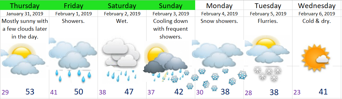
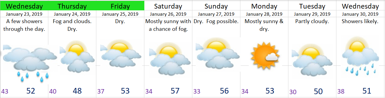
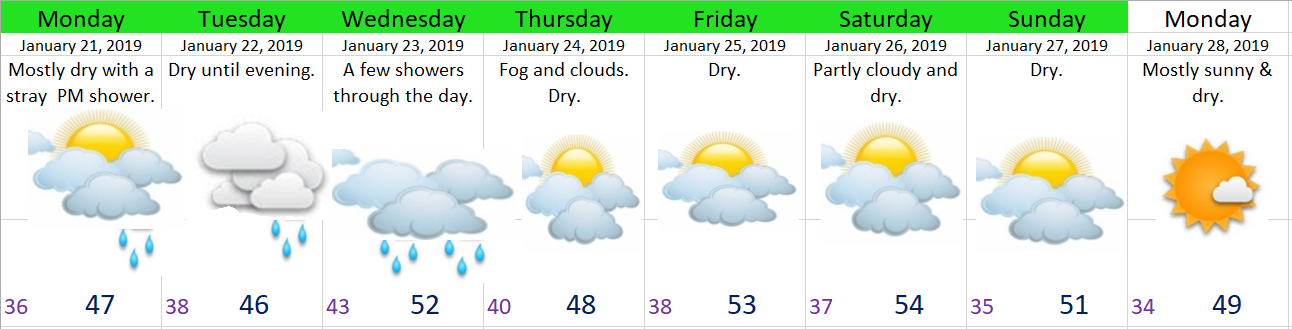
Today:  Forecast is on track for a wet day.

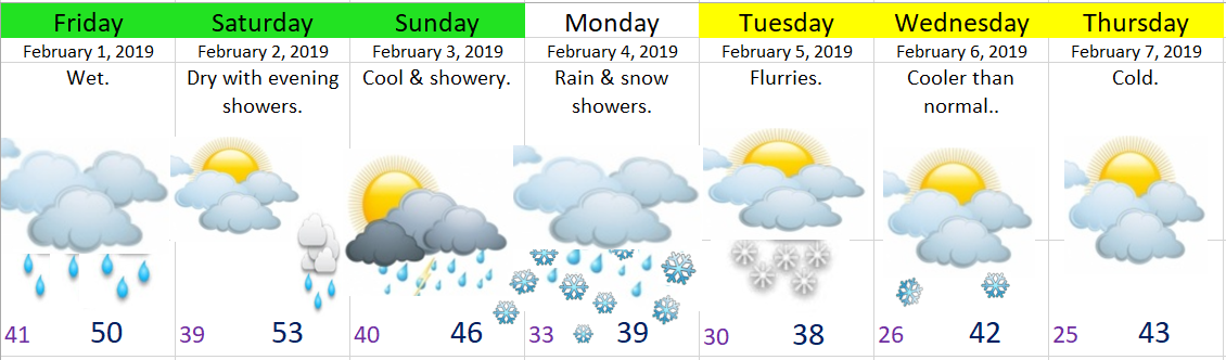
Saturday:  As mentioned, a decent chunk of the day will be dry.  Rain moving in after dinnertime. 

Sunday:  Cool with showers.  The afternoon and evening look to be the wettest.

Monday:  Lots of details still up in the air, but with one new change.  I’ve bumped the temps up slightly for Monday which will make it just a little bit tougher to have widespread accumulating snow on the valley floor.  Note that when I say “slightly” I’m thinking highs 39/40° instead of 37/38° and lows right around 32/33°, so a small difference, and still quite chilly.  Cold enough still to produce at least a rain snow mix for the valley.

Tuesday:  Mostly cloudy with very light rain & snow showers possible. 

Wednesday & Thursday:  With how much things change around here I ought to not say much other than both days look cold lol…


Final thoughts

As I mentioned in the previous update it currently looks as though we will see a lot of snow in the air, but only end up with a dusting or some slush.  For now I’m still not seeing a setup for a good snowstorm.  I still expect many more changes as time goes on and I’ll do my best to relay those to you all.

Winter is Coming!!!

I’ve been waiting all winter to post this….

Brace-yourself-Winter

I imagine by now you have seen or heard forecasts for snow next week.  Well I’ve seen them too and I have to say I’m pretty excited. 

Many details are still up in the air, so I won’t get too carried away with specific snow amounts or anything like that, but I’ll try to sort out what seems certain at this point in time.

Right now I have high confidence in three things happening this coming week.
  1. Colder than normal temps are on the way.  This one is just about set in stone.  Sunday through most of next week will be cold.  Right now I’m going for highs in the upper 30s/low 40s.
  2. Snow levels near the valley floor. Everyone should at least see snow flying through the air, and my confidence is growing that everyone will also see at least a slushy “dusting” of snow similar to last February’s event with the possibility for a bit more.
  3. Unless something changes, this is not a setup for a big snow storm. Notice I’m only talking about a dusting or so for the lowest elevations.  Subject to change as there are hints that we could see some heavier snowfall…

The next 7 days

jan 30


Day by day details & highlights

Tonight:  The atmosphere is going to moisten up just enough to allow some areas of fog or freezing fog to develop.

Thursday:  Unless we get trapped under a blanket of fog it will be mostly sunny and dry like today with another cold start.  Lows starting out in the mid to upper 20s.  Clouds moving in later in the day.

Friday & Saturday:  Wet.

Sunday:  Frequent showers and cool with snow levels lowering through the day.

Sunday night:  Our first shot at snowfall as very chilly showers roll onshore. 

Monday:  By Monday morning I expect at least a dusting of snow just about everywhere with more respectable accumulations in the higher elevations.  This type of pattern favors those of you living on the east side of the valley as that region will receive more precipitation with the cold air posed to move in.

Tuesday:  A few leftover snow showers & cold.

Wednesday:  Looks dry for now, but very cold start to the day.  Coldest lows of the winter likely.

Beyond Wednesday:  All I know is the cold looks to continue…

Fog for the win

All week long I’ve mentioned my concerns about fog developing this weekend keeping our temps cooler than they would otherwise be.  Turns out the fog won.  You can see the entire valley cloaked under the blanket of fog on this visible satellite image from this morning.

fog 1.26

If we had stayed free of the fog (say that 3 times fast) we could easily be in the 50s right now.  Just look at the temp at the top of Santiam Pass right now.  It’s a balmy 54° with more daytime to come.  It will get up to almost 60 up there today!!  Back here in Salem it’s a nice cool 39° thanks to our fog 😉

santiam pass warm 1.26

I see no reason why Sunday and possibly Monday won’t also end up foggy.  In fact there’s a chance for fog almost every single day this next week.  The only exceptions are the days it’s supposed to rain lol…  Here’s a look at the next 7 days.  Notice the lack of green highlighting indicating the variability in our temps which all depend on how much or how little fog we end up with.

jan 26

  • Dry through Tuesday
  • Showers on Wednesday
  • Dry Thursday
  • Wet for next weekend

Last, but not least I have some food for thought.  This graph shows the number of days with highs below 36°F per winter for Salem, OR.  It goes back to the winter of 1997/1998.  In the scheme of things this is a very short time frame, so don’t draw too many conclusions from it.  I just thought it was a fun bit of info to share.

salem cold high temps


Boring winter weather

I’m sure a number of you enjoy this dry weather, but those of you who know me well know I love a good storm whether it be lots of rain, wind, snow, or ice, and sadly we have not had very many good storms at all this year. It’s been an especially boring winter overall with warmer than average temps and drier than normal rainfall, but life goes on.

Highlights

It looks to stay dry and mild for the foreseeable future with the minor exception of Wednesday when some very light rain showers will come through.

Following up on our “warm” weather potential this weekend I’ve decided to lower the high temps just a smudge. It will still be above average, but only mid 50s at best. Patchy fog is possible just about every single day this week which could keep temps cooler than what is currently forecast.


Jan 22nd

This is what we call a miss.  I said “dry until evening” in my previous forecast, but it appears as though the rain came several hours early today.  It’s also been a bit breezier than I expected, so sorry about that.  Tomorrow will be drippy/wet as well before we dry out Thursday and stay dry for at least several days.

jan 22

Additional thoughts

This weekend is a huge wildcard.  We will have a very warm air mass in place, but it won’t do us any good if we get socked in with fog & low clouds.  I’m watching closely, but as of right now I’m hedging my bets on sunny and mild with highs in the mid to upper 50s.  It will no doubt be dry during this time, so you can at least plan on that part of the forecast to come true 😉

After tomorrow’s showers we stay dry until next Wednesday!

Plain old January weather

After a few days without any updates I’m back in the saddle today.  This week’s forecast is looking real bland/plain with nothing exciting in the near future.

jan 21

Details

Today:  A slight chance of a shower later on this afternoon; otherwise, mostly dry.

Tuesday:  Dry start with light rain moving in from the north during the afternoon.  Locations south of Corvallis & Albany should stay dry.

Wednesday:  A few light showers for everyone.

Thursday:  Fog likely, turning partly cloudy as the day goes on.

Friday – Monday:  Partly cloudy & dry.