Rainy Monday

It’s cold out there, clouds are overhead and there are rumors of snow all around.  Well, any snow we see this evening will be very brief and it will melt before any of us even wake up Monday morning.  So no need to worry.  South winds will make it tough to stay cold enough for snow, and in fact the winds will steadily warm us up overnight.  By Monday morning we should be around 40°.

Here’s a link to the latest radar image courtesy of Fox 12 News (and Mark Nelson) to help you keep track of where the rain and snow is falling.

Details

This evening:  Snow, changing over to a mix, and then just plain rain late tonight.  No accumulating snowfall below roughly 500′.  Anyone living close to 500′ and higher could see a quick inch before it melts later on with the incoming rain.

Monday:  Cold rain.  No issues.  Snow level will be all the way up to 2000′.


I’ll have a fresh look at the week ahead later this evening, but four things to know now regarding our week ahead:

It will be very wet.

Widespread valley snow this week is looking a lot less likely at the moment.

We will be staying in a colder and wetter than normal pattern for the foreseeable future which means you won’t have to go very high up in the hills/mountains to find snow and a lot of it.

The mountains are going to get absolutely dumped on with snow.  Especially above about 2500′.

Storm & forecast update

The forecast seems to be on track thus far which is making me pretty happy.  As expected, temps across the mid valley were between 32 and 35 degrees this morning depending on elevation.  In fact elevation made all the difference in the world concerning who saw snow and who didn’t.  Here are some images of the road conditions from earlier.  If you are familiar with these streets then you will notice south Salem in particular was a winter wonderland this morning while the rest of Salem & Keizer had almost no snow on the ground with the higher west Salem hills as the only exception.


The rest of today and tonight:  A few more snow showers will roll in through the course of the afternoon, but they will not stick as we are a bit above freezing now; however cold air is pouring down from Canada and by 4 or 5pm I expect us to be back down to near freezing.  Anything that falls after that point in time should stick, so plan on icy roads starting this evening.

I’m forecasting a decent chance for widespread snowfall tonight as we will have a fairly similar situation to the one that brought us snow earlier this week.  I’ve posted the simulated radar for roughly 3AM.  You can see a nice band of snow directly over us.  We will be plenty cold by this point, so I’m going with ½” – 2 inches for everyone.

snow tonight 2.9

Sunday:  we wake up to a frozen landscape with temps in the low to mid 20s.  It will be a slow thaw as we creep towards freezing by the late afternoon.

Sunday night:  Another storm rolls in which should start out as snow, but will very quickly switch over to rain leaving us with a slushy dusting to an inch at best.

Monday:  I now fully expect Monday to be a cold rainy day with breezy south winds.  Our regular school and work schedules will most likely be just fine this day.

Monday night/Tuesday:  This is a major storm with estimated total precip being around 1.5 – 2”!!!  Now a lot of that is probably going to be rain, but if we are somehow colder than expected this could be a huge snowstorm.  For now I’m thinking we start with some rain change over to a heavy wet snow and then during the day Tuesday we make the switch to freezing rain (briefly) and then just plain old rain.  Tuesday is going to be a rough day for anyone trying to travel.  I’m thinking 1 – 4” for the valley floor with 2 – 6” for the higher hills around town, and up to a foot plus above 1000’.  In addition to that we will likely see up to an inch of rain on top of that Tuesday afternoon which could make for some localized flooding.


Feb 9

Beyond Tuesday we stay in a very cold and wet pattern setting us up for more snow events/storms…

Wild weather ahead!

It truly is going to be an extremely wild couple of weeks regarding the weather, and depending on how things set up such as tracks of the storms, how cold the air is, and how much moisture there is, we could be looking at some very “epic” snow totals.

First things first.  This evening we have a strong front pushing in from the NW bringing a good dose of precipitation with it.  Here’s a link to the radar:


Timeline

Tonight:  Rain, heavy at times.  Snow could easily mix in down to the valley floor, but it will not stick in the lowest elevations initially.  This is tricky business as both elevation and proximity to the Gorge will make all the difference in the world for how much snow everyone sees.

Check out these pics from around 4:30pm.  Snow sticking in the Coast Range of NW Oregon and that cold air and precip is headed our direction.


Possible Game Changers

If temps are just a couple degrees colder than forecast giving us much more snow.

If the low pressure takes longer to drop south then we will end up with mostly just a cold rain.

Precip sticks around longer than forecast Saturday allowing for higher snow totals.


Details

Saturday:  Snow showers with temps holding really close to 33/34° which makes it super difficult to forecast snow totals.  My best guess is a dusting to 3 inches.  4 to 5 inches above 500’.  This is still not looking like a big snowstorm for us Salem people.

Sunday:  We start off cold.  Probably somewhere in the low to mid 20s before warming up close to freezing.  Snow moves in Sunday night giving us another shot at a dusting to an inch or two before changing over to rain very early Monday morning.

Monday morning:  Could end up being a fairly regular first half of the day with a cold rain or rain/snow mix.  Snow levels around 1000’.

Monday afternoon – Tuesday:  I’m watching for what could be a very snowy storm.  In my last forecast I had this storm coming in on Monday.  Well changes happen and expect many more changes to occur over the next day or two as we get closer to the event.  The most recent changes have made the forecast much more complicated.  The amount of moisture has increased since my last update which could give us more snow if it’s cold enough.  There’s also a chance we get plain old rain or freezing rain for part of the storm.  Either way we still look good for at least a couple of inches of snow during this timeframe.

Wednesday – Friday:  More opportunities for snow as we stay in a very cold, but wet pattern. 

Keep checking for the latest forecasts, and keep an eye on the WEATEHR ALERTS tab/page as that’s where I will post updates regarding any last minute “game changers.”   

Summary

Sometime tonight we switch to snow.  Everyone should get at least a dusting of snow and possibly up to 4 inches for the valley floor when all is said and by done Sunday morning.  Our roads might start off slushy/snowy, but I’m guessing that for the most part our roads stay clear much of the day.  As soon as the sun goes down Saturday evening everything will be freezing up quickly making travel anywhere Saturday evening treacherous.

Sunday:  Cold, dry with late day/evening snow.  A dusting to 2”.

Monday:  Rain or a rain/snow mix turning back into snow Monday night.  Another 1 – 3”.

Tuesday:  Freezing rain, rain and snow all are possible.  Basically a big mess.  Should have a lot more actual details within a day or two.

My take away message:  There is no sign of this cold weather pattern ending.  I’ve been saying it and I will say it again, we are looking at a prolonged period of cold weather with numerous opportunities for snow.  Buckle up, because it’s going to get crazy!!


A cold and snowy outlook

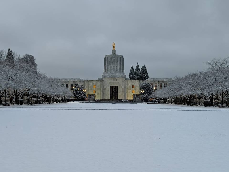
I’ll start off with this awesome pic showing the capitol mall coated in white after Monday night’s little snow storm.

Salem snow Adam Breitenstein
Pic by: Adam Breitenstein

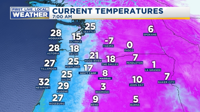
That was a nice little snow event.  It appears as though almost everyone received between one and two inches of snow with a little less on paved surfaces.  Since then we have stayed much colder than normal.  This morning we experienced by far the coldest temperatures of the winter. Look at the bitter cold east of the Cascades!! -7°F in Yakima!

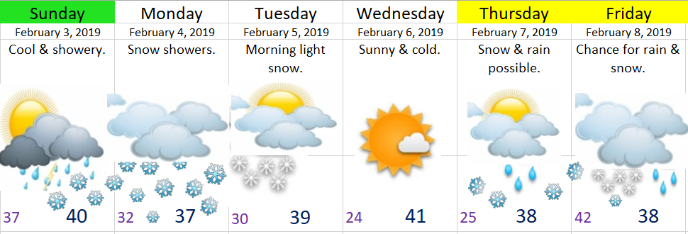
We are in the beginning of what looks to be a very prolonged stretch of cold and snowy weather. The “storm” this past Monday night was just the warm up event. If you’re in a hurry I’ve got the 7 day forecast right here followed by the parts of the forecast I’m feeling most confident about. When you’ve got more time take a look at the important details further down.

First off notice many of the days are highlighted in yellow indicating low confidence specifically in regards to the paths of the storms. The very cold air is certain, but what’s not as certain is how much moisture will fall with each storm and where exactly will each storm go. Something to keep in mind as big changes to the forecast are possible over the next few days especially for Tuesday & Wednesday of next week.

High confidence

Much colder than normal temperatures will continue for the better part of the next two weeks, and possibly even beyond than that.

Multiple opportunities for widespread snowfall. I would say between Friday night and this time next week Salem should at a minimum see 3 to 6″ of snow, and it’s definitely in the realm of possibility we see much more than that.

Lots of snow above 1000′, in the Coast Range, and up in the Cascades.

Lots of snow through the Gorge. In fact, don’t be surprised to see I-84 closed more than once over the course of the next couple of weeks along with other highways around the state.

All the Details

Friday:  The calm before the storm(s), and perhaps the last day roads will be completely snow and ice free for a week, maybe even longer. 

Saturday:  A very interesting day as we should start off very early in the morning with rain before changing to a rain/snow mix around lunchtime & finally changing to all snow by evening as arctic air rushes in from the NE.  I’ll be closely watching the snow levels as they are predicted to not rise much above 1000’, so if precip is heavy enough and/or if temps are a little bit cooler than we could see more snow than current predictions indicate.  We will start the day in the mid to upper 30s before falling into the upper 20s by midnight.  Snow totals:  1 – 2” for the valley floor.   2 – 3” around 500’.   3 – 6” above 1000’.

Sunday:  Very early morning snow showers with lows in the 20s giving way to partly cloudy skies and highs near 32°.  Snow moves back in Sunday night. Snow totals:  nothing – 1”.

Monday:  Snowy much of the day with highs staying below freezing. Snow totals:  2 – 5” for the valley locations.  Up to 8” above 1000’.

Tuesday:  More snow likely.  Just not sure how much yet.  There’s lower confidence on the track of this storm which is why I am less certain regarding snow totals; however, what I do know is a very cold air mass will be over us.  I’m going with high temps between 29 and 32 degrees.  Very cold!!

Wednesday:  Similar to Tuesday.  The possibility is somewhat high that we see several inches of snow between Tuesday & Wednesday.  I should have a much better idea in a day or two. 

Thursday:  Cold and mostly dry.

Feb 6th update

A real quick forecast.  Sorry ahead of time if you’re a visual learner as there are no graphics or pictures in this post lol.  Next time though…..   😉

Today & Thursday:  Dry & cold with highs in the upper 30s.

Friday:  Some very light precip rolls in early morning giving us a shot at snow.  Precip may be too sparse to give us any accumulation plus as the day goes on winds will be switching to the south bringing in slightly warmer air.  So at this point I’m thinking we see nothing – ½”.  Maybe an inch if we are “lucky” before turning to rain.

Saturday:  This is our first shot at some real decent snowfall as a moist system will be shooting down the coastline bringing arctic air behind it.  The path this storm is similar to our Sunday/Monday round one storm, but with three big differences.  The first is more moisture to work with, the second is we have colder air already in place which is huge if you’re wanting snow, and third, this storm is bringing even colder air behind it.

Depending on the exact track of the storm we could either see mostly rain with just an inch or so of snow or we could be looking at several inches.  I’m going with 1 – 3” for now.  Basically rain will change over to snow as the arctic air moves in.

Sunday:  Cold arctic air will be pouring in behind the storm giving us a day with highs not even reaching the freezing making for a very cold day!  Morning snow showers could dump another inch or two before changing over to flurries the rest of the day.

Monday & Tuesday:  Monday morning might start off dry (and very cold) before more snow moves in.  Similar to the other storms, the snow may change to rain briefly before switching back over to snow as cold arctic air rushes back in behind the storm.  This storm could easily give us several inches as well, but again I’m going to stick with 1 – 3” for now…   So much more to come with more updates and details.  It’s looking like a crazy couple of weeks…

Snow & forecast update

Who got snow and who didn’t…

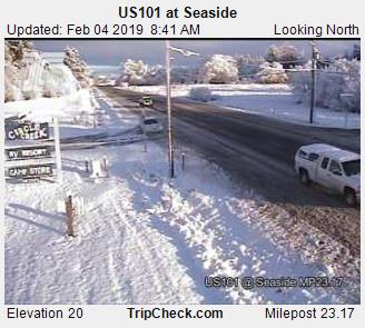
As always “the devil is in the details” lol…  It looks like the east side of the valley did in fact do slightly better in terms of snowfall (and they could get more), especially considering Salem has nothing still.  The Coast is the biggest winner so far with many locations north of Lincoln City receiving 1 to 4 inches of snow.  Even down to sea level!!  This pic of highway 101 near Seaside from earlier really shows the winter wonderland over there.

Seaside snow 2.4

Since Salem once again missed out on the snow I thought I would share this collection of pics from locations around the region to help ease the pain 😉

*The pic with the red truck was taken along at the coast near Astoria, the beach pic is Haystack Rock, the ruler pic is from Cannon Beach, & the snowy house is from Washougal.*

ENJOY!


This slideshow requires JavaScript.


A quick recap of our “storm” so far

The Good

Cold air aloft had little trouble making it here.  I understand it’s not crazy cold down here in the valley, but you don’t have to travel far to find temps below freezing. 

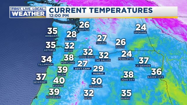
Here are the temps around the northwest as of noon.  A very chilly air mass!!  Look at Seattle still in the mid 20s!  That’s some cold arctic air just to our north!

noon temps 2.4 

The forecast for the coast and Coast Range worked out very well with all those areas receiving snow and in some places a bit of it. 

Forecast for the east side of the valley went okay.  Not as much snow as I predicted, but in general east side locations like Stayton and Scio all ended up with a dusting which is more than Salem got, so I’m giving myself a passing grade on this part of the forecast.

The bad and the ugly

Not enough moisture.  Many of the weather models and consequently myself overestimated the amount of precip that would make it into the valley.  If you want snow in a pattern like this then you need heavy or steady precip to literally help “pull the cold air down.”  Yes, that’s actually a real thing as steady precip often times forces & brings cold air down with it from higher up.  This is exactly what happened at the coast which is why they ended up with snow and we didn’t.  I banked my forecast on at least a few more showers making it over the Coast Range and that did not happen. 😦


So what’s ahead?

A weak band of precip will slide primarily along the east side of the valley producing snow in the air.  Snow will not stick due to the “heating of the day,” but if the precip can stick around into the evening hours than locations like Silverton, Canby, Molalla, Scio, and Stayton/Sublimity could all see a dusting of snow. Emphasis on no more than a dusting as I don’t see a lot of moisture to work with, plus we are several degrees above freezing currently.

Possible game changers
  • Depending on where the precip band shifts we could see no snow even in the air or more snow if it moves close to us.
  • If moisture is heavier than forecast we could end up with a nice snowy night tonight.

Looking further ahead

Tuesday – Thursday:  Vast majority of this time will be dry.  A light rain or snow shower is possible Tuesday afternoon & evening, but that’s it.  Partly cloudy skies should rule the day.  Just keep in mind it’s going to be chilly.

Friday – Sunday:  Closely watching for a better opportunity for widespread and possibly significant snowfall.  None of this hit or miss weak shower stuff.  More to come on this potential tonight or tomorrow.


Sunday morning update

Big time forecast right here with a lot to cover, so let’s get down to it!!  Highlights first and then the extra details.

Feb 3

Highlights

Today:  Showers much of the day with snow levels around 500’ – 1000’.

Tonight.  Snow level drops down to the valley floor.

Monday:  Snow showers throughout the day with highs in the mid to upper 30s.  Everyone should at least have a coating of snow with a few inches very possible for those of you around 500’ or higher.  A cold day for sure!

Tuesday:  Very light snow early on turning partly cloudy in the afternoon.  Highs will be close to 40°.

Wednesday:  Cold & dry.

Thursday – Saturday:  More opportunities for snow as both cold air and moisture come together right over our area.  More on that another day, for now you just know that this cold and potentially snowy weather is going to continue for a while.


Details, and lots of them 😉

I’m watching very closely our temps both at the surface and up above to help determine our chances for sticking snow on the valley floor.  It seems likely that we all see at least a coating of snow with the higher hills around town picking up 1 – 3 inches through Monday evening.  Keep in mind that it’s possible our roads stay mostly clear even if we get a little coating of snow as it’s hard for snow to really stick to pavement when it’s only 32/33° especially during the daylight hours.  If we stay just a couple degrees colder than what I’m thinking and or if there ends up being more moisture then we could easily see more snowfall.

Monday night into early Tuesday a band of light precipitation will likely drop another dusting of snow for just about all of us.

I continue to believe that the east side of the Willamette Valley will see higher snow totals these next few days as the moisture and snow showers sort of “backs up” against the foothills of the Cascades.

Beyond Tuesday there are three things popping out at me.  One is the nice dry break in the weather Tuesday afternoon through Wednesday night.  Second thing is the consistency in the weather models showing more opportunities for snow starting Thursday and lasting through next Sunday.  In fact I have fairly high confidence we see even more snow during that second half of the week than we see these next few days!

The third thing is perhaps the most interesting thing to me.  Starting today it appears as though we will be entering into a near historic cold spell.  Not historic because of how cold it will be, but historic due to the sheer length of time I expect the colder than average weather to last.  I understand this could change, but I have to say that in all my experience forecasting weather I have rarely seen this much agreement between models for the extended period which leads me to believe this colder pattern is going to last quite a while.  Naturally one would expect increased chances for snow with such a cold pattern, and that’s exactly what I’m seeing.  In fact I see numerous opportunities for snow over the next couple of weeks.  So like it or not, it’s quite possible we are in for a very prolonged February cold spell!!


The Coast, Coast Range, & Cascades

Snow should fall to sea level Sunday night and Monday.  This pattern also favors snow along the coast.  The Coast Range will be very snowy with 4 to 8 inches expected now through Tuesday, and the Cascades will of course be snowy as well with 6 to 12 inches up there over the next 3 days.


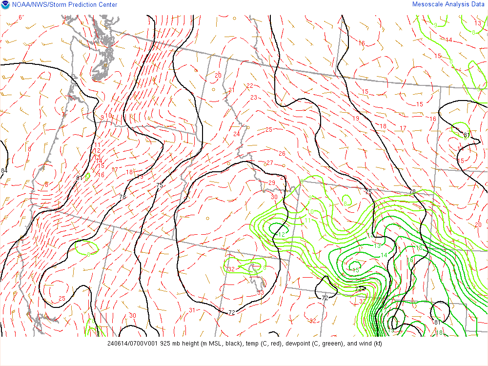
Some fun “do it yourself” forecasting tools for predicting snow

You may want to keep an eye on these maps as they are some of the best indicators as to whether or not we will have snow.  I don’t think I’ve had links like this so hopefully they work 😉

This first map shows temps in Celsius at roughly the elevation of Santiam pass (about 4,800′).  When winds are out of the south or from the west (onshore winds) we generally want to see at least -6° or colder in order to see sticking snow to the valley floor.  “Warmer” temps can do the trick just fine if and only if: 1.)   the precip is heavy enough,  2.)  the winds are very light or calm, or 3.)   if winds are out of the north or east like the cold winds out of the Gorge.  Basically as long as we are on the blue side of the lines.

This second map shows temps in Celsius at about 2500′ in elevation.  If you are rooting for snow than all we typically need is to be somewhere in the blue.  It’s better to be at -2°C or colder, but even 0°C at this elevation can do the trick if precip is heavy enough or if the winds are light or calm or from the north or east.