Wet AM commute then dry…

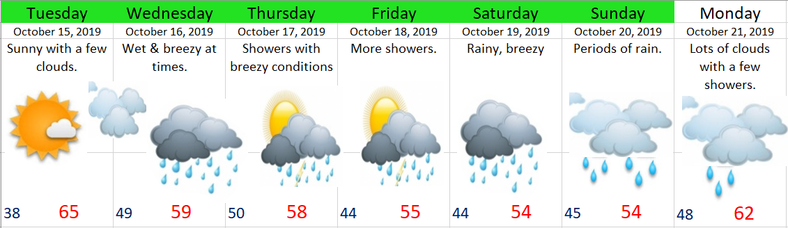
Tuesday morning’s commute looks rainy, but come lunchtime the rain will already be over with as we quickly enter into a dry pattern with mostly sunny days the rest of the week.

On Thursday and Friday our high temps will be close to 70°, so a nice and dry late October week is in store.  Enjoy it while it lasts as this week will almost certainly be our last shot at 70 degree weather until March.  Sorry warm weather fans, but it’s just that time of year, and winter is coming……..


Enjoy and be safe!!

Wet week ahead

Monday was sure nice, at least weather wise, and Tuesday should be equally nice with sunshine most of the day.  Enjoy it while it lasts because we will be kicking off several wet days starting this Wednesday.

10.14.19

Highlights

Wednesday:  Rainy at times with breezy conditions.  I imagine winds could gust around 30mph which is fairly typical for a mid October storm.  Nothing to wild, but enough to blow a lot of leaves around.

Thu – Fri:  Showery with more gusty winds at times.  Some showers will be quite heavy, so keep those drains unclogged if you don’t want ponds in your street.

Sat – Sun:  Cool and wet.

Monday:  Slightly warmer, lots of clouds, and a few showers.


2 Dry days

A super quick post this morning before heading out for the day.

Highlights

Today and tomorrow:  The only dry days of the week.  Highs should top out between 63 and 66 degrees.

Wed – Sun:  Rainy.  I’ll have more details concerning the rest of the week’s forecast in a post later tonight just in case “rainy” isn’t detailed enough for you 😉

Enjoy the sunny weather and have a great Monday!!

A crisp October week

Did you enjoy the weather today?  If so then I have some good news for you as most of this coming week will be a near repeat of today’s weather.

10.6.19

Details

Monday:  Sunny with clouds rolling in around dinner time.

Tuesday:  Looks to be the only wet day this week, and honestly it won’t be all that wet.  Lots of clouds, but only a tenth of an inch of rain or so.

Wednesday – Friday:  Cold mornings with lows close to freezing, but sunny and mild afternoons with temps getting up into the mid 60s Thursday and Friday.  Very nice October weather if yo ask me 🙂

Saturday & Sunday:  Partly to mostly cloudy, dry most of the time with a chance for a couple of showers Saturday night through early Sunday morning.

Next Monday:  Partly cloudy with highs close to 60°.


Showers likely this evening

We have a batch of heavy showers moving south towards the Salem area right now.  These showers have produced heavy rain, hail, and even some lightning & thunder in the Portland area.  These showers are also cooling the air mass down quite a bit.  Look how cool Portland is compared to Salem as of 5PM.

5pm temps.jpg

Tomorrow and Monday will be unusually cold for this time of year with lows in the mid to upper 30s and highs struggling to reach 60 degrees if with sunny skies.

Enjoy the showers, and enjoy your Saturday evening!!

Diving right in

We seem to be wasting no time diving right into the rainy season this year.  For starters Salem set a new daily rainfall record this past Tuesday with 0.96” of rain falling with those intense thunderstorms we had.  Plenty more rain on tap, specifically during the first half of the coming week.

Here’s a look ahead:

9.15

Highlights

Today:  Rainy much of the day.  Heavy at times.

Monday:  A typical sunbreak and shower type of day.  Everyone should see heavy downpours of rain and or hail, and some of you will likely experience thunder & lightning like we saw this past week.

Tuesday:  Rainy, windy, and cool.  Winds could gust around 30 or even 35mph during the afternoon.

Wednesday:  Near Repeat of Monday.

Thursday:  A lot more sunbreaks with only a couple PM showers.

Friday:  For now I’m going with a slight chance of a PM shower.  Majority of the day should be dry.

Saturday:  Leaning towards this day being partly cloudy and dry, but lower than normal confidence means this could easily change.

Thursday morning update

A quick update before you head out the door this morning as we have a chance for showers and maybe a few thunderstorms today.

Timing

This morning:  The possibility for a few regular – plain old showers exists through about 9 or 10am.  Very slight chance for a thunderstorm during this time.

10AM – 4PM:  Should be mostly dry, with lots of sunbreaks.  With the sun out we could easily get into the 80s today.

After 4PM:  Chances for thunderstorms and showers goes up.  No guarantees of course (it’s Oregon after all), but a fairly decent chance for our standards.

The Cascades & Central Oregon

These regions will almost certainly experience storms today.  In fact, there are already storms firing up near and south of Bend now.


Looking ahead

Sunday through Tuesday of next week looks showery.  Not a washout, but definitely wet at times.

Remember to follow me on Instagram as I post occasional updates on there, especially when I’m on the go and away from the laptop.

https://www.instagram.com/bryanweatheralerts/

Have a great day!!!