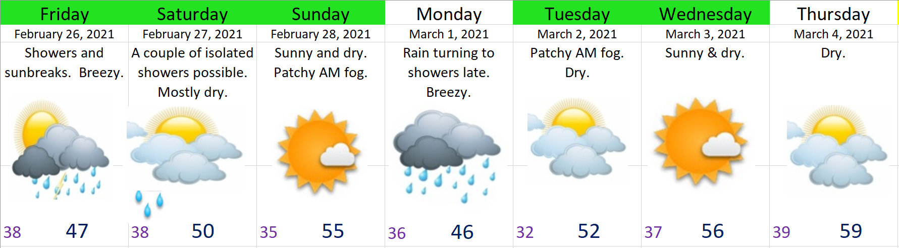
February 2021 is coming to a close and March is just around the corner. Here’s how the next 7 days are looking:
HIGHLIGHTS
1.) Friday: Cool and breezy with rain and hail showers, sunbreaks.
2.) Saturday morning through Sunday night will be dry. I can’t help but feel like someone was praying really hard for a dry weekend, because that is exactly what we have on tap. Temperatures are going to be chilly in the morning hours; however, the late February sun should help keep things more reasonable during the day.
3.) I’m calling for rain for Monday with breezy winds of 20 to 30mph – a stormy day. Some of the weather models have this day totally dry which is why I’m not as confident about this forecast, but for now plan on it being a wet day.
4.) Tue – Fri should be dry. Watching for the chance of rain on Friday, but other than that, most of the work week will be dry and mostly sunny! I wouldn’t be surprised if some locations in the valley hit 60 this week either Thursday or Friday. Yes, spring will be trying to make an appearance this week. 🙂
The Cascades
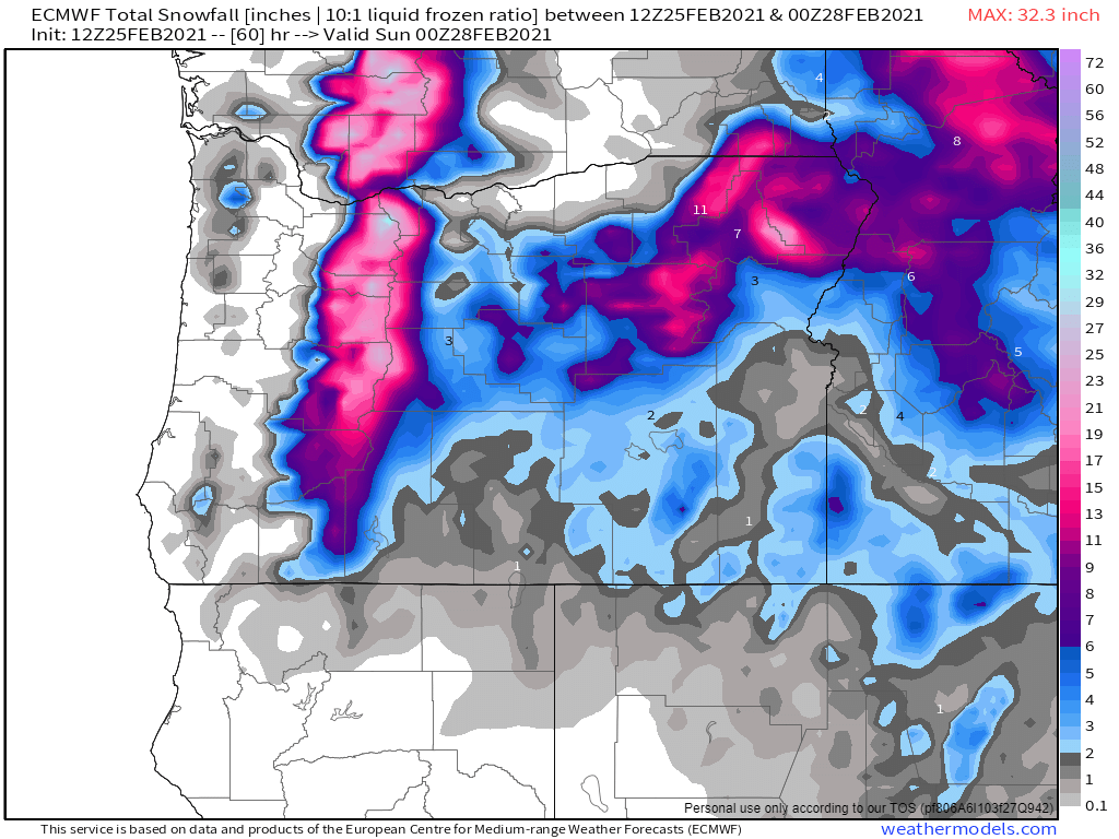
Up in the Cascades snow levels will hover around 1500 – 2000′ with tons of fresh snow up there over the next 36 hours. This chart is showing 1 to 2 feet of new snow now through Saturday afternoon depending on elevation. This is in addition to the several inches of snow which fell all day long today. It’s going to be quite the snowstorm up in the mountains as winds will be gusting 25 to 35mph creating near whiteout conditions at times on Friday. Not a good time to travel up there. Saturday and Sunday will be much better, especially after around noon on Saturday.
It has been a LONG several days. Internet and electricity have been scarce and hard to come by, and after putting out so many forecasts last week it was nice being able to just relax and take a little break now that the weather has slowed down again. I’ll be writing a more detailed post with a look back at what ended up being a truly historic and extremely destructive ice storm later this week. My initial thoughts are that the forecast ended up working out pretty much as anticipated with only a few minor changes/surprises. As the storm got closer and closer it became evident a major ice storm was coming, and it was absolutely shocking to see it fully materialize the way it did!!
Looking ahead we have fairly “normal” February weather on tap with periods of rain, showers, occasional sunbreaks, and lots of mountain snow. Temperatures will be running a few degrees below normal now through Saturday, but not enough to bring wintry weather back into Salem for now…
Wednesday will be the driest day of the next 7. Saturday could end up being mostly dry as well. Expect rain and showers Thursday and Friday.
There you have it!! Stay safe out there and I’ll catch you all in a day or two with a look back at our historic ice storm plus a more detailed extended forecast.
We have just under 2 hours of okay diving conditions before things turn bad and roads freeze over this evening. I want to emphasize again how this “second” storm will have much more of an impact than the one last night. Salem never rose above freezing today and we won’t. In fact we will probably cool off 2 – 4 degrees this evening back into the upper 20s. Brrrrr!!!!!! Here’s another temp update as of 4PM. Notice the bitterly cold air east of the Cascades and the sharp contrast in temperature from Salem to Roseburg where it’s a balmy 53 degrees!! It’s always amazing to see just how powerful the gorge can be in bringing cold air into the northern Willamette Valley.
Freezing rain has been slowly accumulating on elevated surfaces and objects all day long as temps have not gone above 30. There’s a lot of freezing rain coming with this next storm system and I expect roads to freeze up quickly as soon as the sun goes down. I’m thinking half an inch to almost an inch of freezing rain will fall between now and noon Saturday which is going to take a major toll on trees and powerlines. I fully expect lot of power outages and downed trees tonight and tomorrow. Below is an estimated radar image for 10PM this evening. The dark pink and purple coloring around Salem indicates heavy freezing rain and with temps in the upper 20s. This is definitely going to end up as a top tier/historic February ice storm for Salem!
Freezing rain should extend down to Corvallis and Albany, but I’m thinking those locations may warm up a little bit sooner on Saturday which could keep them from seeing as much ice as Salem.
Snow could still mix in at times here in Salem the way it did last night in areas west and north of downtown, but overall freezing rain will be the main precip type.
Roughly Wilsonville northward is still on track for some heavy snowfall. There will be areas of Portland that end up buried under a foot plus of new snow by this time tomorrow! This is shaping up to be a truly epic February snow and ice storm for our region!!
Salem should rise above freezing Saturday afternoon at which point we should stay above freezing and begin to melt/thaw out.
Portland may not thaw out real well until Monday, especially parts of the metro area that are located close to the gorge.
Okay, I think I covered everything. Be safe out there!!
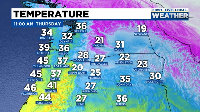
From what I can see out there we still don’t have any major surprises going on yet which as a forecaster is always a relief lol. There is a nice layer of ice on basically everything outside here in Salem. Trees, plants, and cars are all coated in a glaze of ice. Our major roadways are looking okay; however, most of our sideroads and parking lots still have a lot of slick spots of ice on them. Be very careful out there and drive or walk as if there could be ice even if it looks just wet. Here are regional temps as of 8AM:
You can very clearly see the influence of the Columbia River Gorge with very cold air moving west right into the northern Willamette Valley. Roads should thaw out slowly and driving conditions shouldn’t be all that bad on the main roads thanks to our limited “heating” of the day, but don’t be fooled into thinking we are all done. This second storm moving in is juicy and will be packing quite a punch.Unlike last night where the freezing over process was slow, main roads tonight will freeze over very quickly between 2 and 5PM depending on temps and how heavy the precip falls this afternoon. It’s worth pointing out that some of the side roads around town may not even truly thaw out before this next round of freezing rain and snow moves in.
Freezing rain will again be the dominate precip type later today through Saturday morning with sleet and a little bit of snow mixing in at times. As mentioned, this storm has a lot of precipitation with it, so the potential is there for some serious ice accumulations. Tonight and Saturday morning will be the “main event” of this whole wintry weather ordeal. This is also the time frame that some of you may lose power due to what could end up being heavy freezing rain.
Portland is still on track for a major snowstorm later today through Saturday morning. I’m thinking 6 to 14 inches up there depending on location. A crazy big snowstorm for them!
In theory Salem should begin to thaw out Saturday afternoon – at least some. This is subject to change of course, but as for right now that is the plan.
Alrighty, there you have it! Plan on main roads being okay for the middle of the day, but turning bad quickly late this afternoon/early this evening, and plan on power outages tonight with lots more freezing rain tonight and tomorrow with varying amounts of snow and sleet mixed in.
Happy Thursday everyone! From what I’m seeing it appears as though the train is still on the tracks for now. Hahaha!!! Check out regional temps as of 11AM:
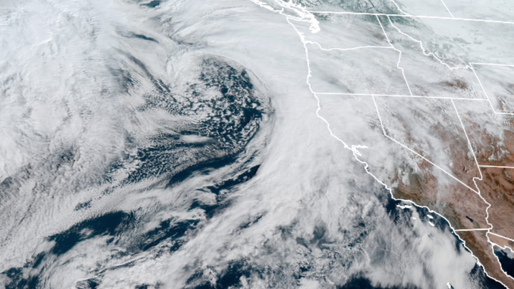
As you can see there’s a lot of very cold air east of the Cascades which is blasting through the gorge straight into the northern Willamette Valley. Next take a look at the satellite view of the storm rolling in. It’s a beast of a storm!!
The greater Portland metro area: All of Clackamas, Washington, and Multnomah counties, as well as parts of Yamhill County are looking at what will probably be a major top tier snowstorm. Locations further south like Wilsonville and Newberg may only pick up 2 to 6 inches of snow, while cities both close to Portland and cities north and east of Portland could easily see – and I’m not kidding – well over a foot of snow between now and Saturday afternoon! Plan on Portland being an absolute mess through Sunday, perhaps even into Monday with Portland metro roads freezing up and turning snowy before the PM commute this afternoon.
THE SALEM AREA
TIMING: Salem falls below freezing tonight. The cold air is currently spreading down into our region at a more “aggressive” rate than what some models were initially showing. Due to this fact, I’m feeling confident that Salem drops below freezing between 7 and 10PM tonight. This is a little bit sooner than what I said in my last update.
What to expect: For today we will only see cold rain. I’m still thinking we end up with a brutal mix of freezing rain, some sleet, and a little bit of snow at times beginning late tonight and lasting on and off through Saturday morning. My concern is that freezing rain will be our dominate precip type for the duration of this event. This could end up being an extremely hazardous and dangerous ice storm for the immediate Salem area. I’m thinking lots of trees, tree branches, and limbs coming down.
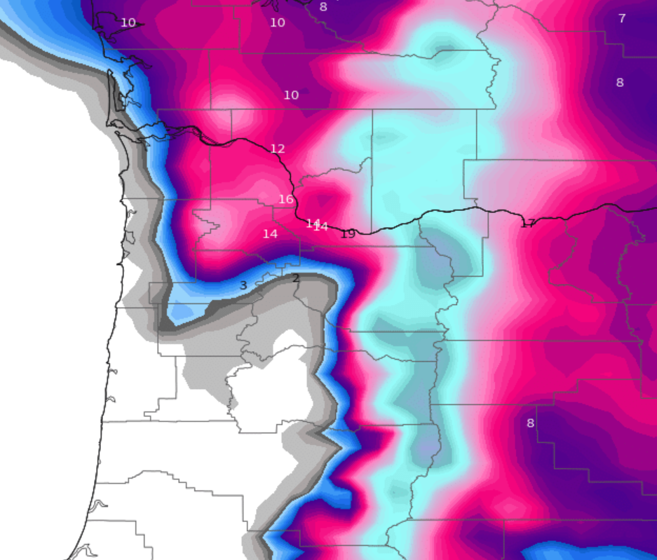
Because we are so close to the deeper cold air, it is very likely that we switch back and forth between freezing rain, sleet, and snow over the next two days. Being right on the edge of the cold air will cause us to do a lot of switching between precip types. I want to illustrate why this forecast is so tricky. This first pic shows estimated total snowfall in inches ending Monday morning.
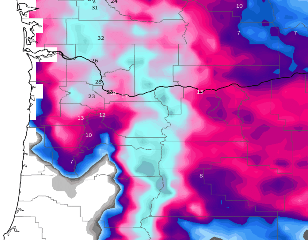
If this model is correct, Portland will end up with 12 to 18 inches of snow while Salem sees maybe an inch or two at most (I’m accounting for the cold air being slightly further south than what this model predicted.) In this scenario Salem would see a better part of an inch of freezing rain!! This could easily be one of the more serious ice storms we have seen in at least a decade. HOWEVER…… 🙂 Check out this next map from the other major weather model. It shows what could happen if the cold air is even more aggressive in moving in, with Salem receiving over 10 inches of snow and only a little bit of freezing rain.
If you take a blend of these two models, which is sorta what I’m doing, you end up with a lot of freezing rain and a little bit of snow. As much as I would like a ton of snow, I’m leaning more towards the freezing rain outcome being correct with just some snow here in Salem. I do recognize, however, that if things trend a little bit colder we could still see a big snowstorm here as well!
Either way Salem should stay close to or below freezing tonight through Saturday morning/early afternoon. This time of year it’s possible roads could be okay to drive on during the peak daytime hours on Friday if precip lets up and if we get a break in the clouds, but don’t bank on that. Drive as if they are still icy, stay safe, and plan on roads being a mess beginning late tonight through Saturday morning. At some point Saturday afternoon we should warm up above freezing and begin the melting process here in Salem. Portland will take longer and may not thaw out until Sunday afternoon.
I will continue to check real time observations to see if we are running warmer or colder than expected, and there are always little surprises that happen which simply can’t be forecasted and it will be interesting to se what actually transpires. Anyway, no promises on when the next update will be, but keep an eye out and plan for an icy few days with more snow the further north you go.
I’m using the words “wintry” because currently it’s looking likely that we end up with regular rain, freezing rain, and maybe sleet, but not necessarily so much in the way of snow here in Salem. So much to cover and so little time lol, so let’s dive right in!
1.) A chilly, but very light east wind is already beginning near the Columbia River Gorge, and by Thursday afternoon it should be just blasting through the gorge transporting very cold air into our region. Right now the cold air is still making it’s way south and west towards us. Here are regional temps as of 9PM:
As you can see we have a long ways to cool before we will be cold enough for freezing rain or snow. This event will largely be gorge driven as that is where the coldest air will be coming from. The Portland metro area is always the more favored spot for seeing lots of snow in this setup, and to a lesser extent the west side of the Willamette Valley is also favored some as cold air blowing west through the gorge sort of pools up against the Coast Range.
2.) Light rain at times arrives Thursday morning. It will be a cold rain, but I expect Salem to stay above freezing during the daytime hours. Portland will likely freeze over around sunset give or take a few hours, so if your plans take you up there keep this in mind. Salem may not freeze up until some time between 9PM and 3AM early Friday morning.
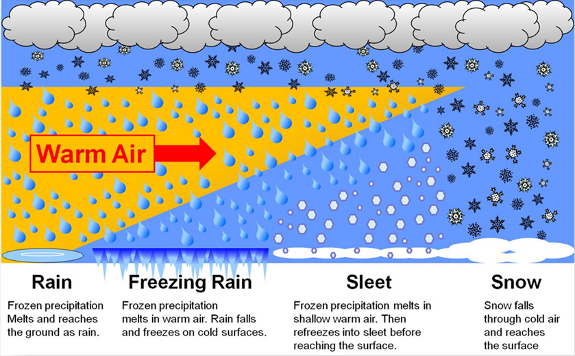
3.) The bad news is I’m not sure we will get very much snow. Salem will likely see mostly rain, freezing rain and maybe some snow mixing in occasionally. Snow chances increase the further west and north you live. In case you’re not sure how or what causes freezing rain check this graphic out below.
Basically the cold air Thursday night through Saturday won’t be deep enough for snow here in Salem as of right now.
5.) Storm number two comes in Friday afternoon through Saturday. This is the storm that should bring us the majority of our freezing rain and if things work out just right maybe some snow too.
FOR now, the most likely scenario I’m going with for now is we get plain old rain Thursday, and freezing rain Friday & Saturday with maybe half an inch up to 4 inches of snow and sleet mixed in. Could be a day were we switch back and forth between snow and freezing rain – what a mess!
Far less likely scenario is we see a lot of snow Friday & Saturday like 6+ inches. If the cold air overachieves and is deeper than expect then this scenario could happen which is why I’m mentioning it. Currently this is not expected to be the case.
Even less likely, but still technically possible is we end up with the coldest rain you’ve ever seen. This seems extremely unlikely based off of the trends I’ve seen, but if for some reason the cold air stalls just to our north we could be looking at a ton of 33 degree rain. Woo hoo!
Locations north of roughly Wilsonville will see significant snowfall of 5 to 12+ inches by Sunday morning. Locations between Wilsonville to roughly Salem will be in the messy and difficult to forecast rain, freezing rain and snow mix zone. Salem down to Albany should receive at least some accumulation of freezing rain Friday and Saturday, and again, very slight chance, but the chance exist that we see snowfall here if things work out just right (SLIM CHANCE THOUGH). With freezing rain likely the possibility exists for power outages, damage to plants, and lots of tree limbs down.
Phew!! I’m exhausted! Okay, time for a relaxing evening and I’ll give you all a nice update tomorrow morning or early afternoon!!
A super quick update with no fancy pictures, charts, or maps. Just the basics. I will have a full update Tuesday afternoon/evening for you.
Highlights
1.) Tue & Wed will be chilly, especially in the mornings, but should stay mainly dry. Good days to go to work, travel around, and run errands.
2.) Thursday should be okay for travel too. I expect rain during the day with temps dropping as the day goes on.
3.) Thursday night into Friday morning we transition to either freezing rain, snow, or a wintry mix of both.
4.) There is a very good chance for wintry weather and significant impacts to travel in the Mid Willamette Valley from the moment we switch to frozen precip Thursday night/Friday morning all the way through Sunday, and perhaps even into early next week. It’s looking more and more likely that this will be a multiday event with several rounds of snow and or ice. Make sure you have all your errands done by Thursday afternoon just to be safe, and for now plan on roads turning bad possibly as early as Thursday night and lasting until Sunday, again maybe even longer.
I should have more details for you tomorrow. It’s going to be an exciting week around here!