Heatwave update

The weather is absolutely wicked right now. Yesterday we set the record for the hottest temp ever seen here in Salem for the month of June with a high temp of 105°. Today we are seeing the hottest weather we have ever had here and it feels like it too. Check out our 4PM temps:

112°!!!!! What else can I say? It’s way too hot out there. 112 degrees is 4 degrees hotter than Salem’s all time hottest temp ever recorded, so we are smashing records today. Notice the central Oregon coast. It’s a nice 72 at Newport right now…

The only good news is Salem will “cool off” a little quicker than the Portland area will on Monday. We may see our high temp tomorrow closer to 1 or 2PM before cooling down some whereas today our high temp will likely come after 5PM.

Tue – next Sun: Highs 90 to 95 which is still really hot and way above normal, but definitely not as extreme as what we are seeing now. Lows should also dip close to and even below 60° after Tuesday making it easier to cool off at night.

Extreme heat

The forecast is still on track this afternoon. Basically we have “out of this world” record heat on the way through Monday with more regular Pacific Northwest heat continuing afterwards.

Here’s my latest 7 day forecast

A few thoughts for you all

1.) As mentioned in my previous forecast I can’t emphasize enough just how hot it’s going to be. It’s already hot out there as we are topping 90° right now, but it’s about to get even hotter. We could be looking at several hours of 100+ degree weather Sat, Sun, and Mon which would be a drastic difference from our typical heat waves were it takes all day to reach 100°. This is going to be rough. I’m telling you now in case you haven’t heard it enough elsewhere lol… The nighttime lows are also going to be much much warmer than normal making it tough to cool off houses and buildings at night. Please check up on and keep in mind those who do not have AC.

2.) I got to say it feels weird forecasting a high temperature of 111 as it would be hotter than anything we have ever seen here since records began in Salem over 120 years ago. Salem’s all time high temp is 108° recorded back in August 1981, and it blows my mind to think we could top that and maybe even by several degrees…

3.) The other thing to note is Salem may not be quite as hot as Portland for a few reasons. The biggest reason is there may be a push of slightly “cooler” marine air coming up from the south (yes, the south lol) Monday afternoon which should keep us several degrees cooler than Portland that day. Of course this only means we may be a few degrees over 100 whereas Portland could easily top 110 again that day too. Portland also has a more intense urban heat island effect than Salem keeping their temps a little bit warmer specifically in scenarios like this.

4.) There’s no sign whatsoever of below normal or even normal weather coming up. Basically nothing but hot weather for the next 10 plus days at least.

5.) Another reminder to be prepared should something unexpected happen like the power going out. If you’re able to, having a reasonable amount of supplies on hand is a prudent course of action.

6.) Conserve energy when possible to help ease the stress on the power grid.

7.) Lastly, please stay cool, safe and stay patient with each other. Heat has a way of making us short tempered and cranky. Try hard to be extra patient with those around you this week as it’s going to be brutal for everyone.

Lost its mind

The weather is losing it’s freaking mind. That’s how I felt after glancing over all the weather models today. The hot weather we have seen this month has already been historic in some manners, but to think the hottest and most extreme heat is yet to come is just mind boggling. Below is my best guess for the coming week. Keep in mind that other than our brief 5 day wet spell, this month has been and will continue to be way above normal.

Important things to note:

Whether we end up closer to 99 or a brutal record 110+ degrees, the screaming message here is it’s going to be scorching hot for several days in a row. These conditions will be dangerous for anyone working outside, or anyone who is living or working in an indoor facility that doesn’t have AC. Nighttime temps will also be some 15 to 20 degrees above normal making it even harder for people to cool off houses and buildings at night.

It’s becoming increasingly likely that this will be a historic heat wave which means you need to be prepared if you’re not already. In the past couple of years we have been through Covid, a historic fire and smoke disaster, and of course most recently a historic ice storm leading to power outages – a number of which lasted well over a week. Too many “historic” fill in the blank events lately don’t you think??? It’s definitely a good idea to be prepared for disasters and emergencies including having extra food, water, essential toiletries, medications, light sources, and sources of heat on hand at all times. Okay, okay, so the sources of heat won’t be needed necessarily anytime soon, but I know thousands of Oregonians were happy to have such sources back in February when it was 30 degrees and no power…. Anyway, I’m not promoting hording. In fact, hording is something I think people should avoid lol; however, there’s something to be said about keeping extra supplies on hand and gas in the car for when disaster strikes. In this particular case having food, water, and a plan to stay cool should the power go out are perhaps the most important things you can do to be prepared. Please keep people who may not have AC in mind also as weather this hot can be deadly as this type of heat is something we are not use to.

Finally, last, but not least, be aware of how much energy you are using as strains on the power grid are expected. Stay cool of course, but try your best to conserve energy in other areas. Just some food for thought.

Okay, stay cool! I’ll likely have an update for you all on Friday.

Extended Forecast

1.69 inches of rain fell in Salem between Friday and Tuesday making that the wettest stretch of days we have seen since the ice storm back in February! Goes to show just how dry this spring has been. It was good to see so much rain fall across the region as we desperately needed it.

Looking ahead I see lots of warm and even very hot weather on tap with highs in the 80s both Friday and Saturday.

Highs soar into the 90s for the second time this month on Sun – Tue. Monday will be the hottest day with highs reaching the upper 90s and lows only down into the mid 60s. YIKES!!!!

Very warm weather continues through most of next week as well with one possible twist. I’m watching for a chance of thunderstorms probably just along and east of the Cascades on Tuesday, but this could change as it’s still several days away. Definitely something I’m keeping an eye on.

Enjoy the hot weather, and stay safe and cool.

Active weather

A quick update regarding our wet weather. Currently, I hope you are enjoying the nice dry break we are seeing right now. In fact, we should have several more hours of dry, increasingly humid, and mild conditions with temps reaching the 70s this afternoon; however, a very moist “slug” of moisture is posed to move in during the later evening hours. Right now I’m thinking rain moves in after 6PM. Rain continues Saturday night through most of Sunday. Expect Sunday to be very wet. The rain tonight and tomorrow is really going to favor the coast, Coast Range, and the western half of the Willamette Valley. This rainfall map (through Monday evening) shows this well.

You can also see tonight’s storm system moving towards us on satellite by using the link below:

  • We should see a few more breaks in the rain on Monday with showers increasing late in the day along with an elevated chance for thunderstorms over the Cascades.
  • Sunbreaks, PM showers, and thunderstorms on Tuesday. The Monday afternoon through Tuesday evening time frame contains our best bet at seeing thunderstorms around here. Thunderstorms will be more likely the further north you go, but Salem should still at least see some nice downpours this day. We dry out quickly Tuesday evening after roughly 6PM. All this rain is going to add up. This map shows the expected rainfall through Tuesday night. This is on top of the nice rainfall we saw Friday!
  • After the rain we dry up on Wed with AM clouds & PM sun. Highs in the upper 70s.
  • Thu – next weekend will be very summer like as highs climb into the 80s with lots of sunshine!

Have a great weekend and stay safe!

Weekend forecast

First off I have to say the showers this week have underperformed just a little. Salem has officially picked up a mere 0.03″ of rain since this cooler & “wetter” weather began back on Saturday.

The main “rain event” from the start has been and still is looking to be Friday through next Tuesday as several waves of moisture ride up into western Oregon. Trying to pinpoint exactly when these waves of moisture will show up is proving to be more difficult than usual due to the trajectory/path of this storm system. The main thing to keep in mind is we will have several rounds of steady rainfall Sat through Tue with breaks of dry weather mixed in between. There will also be a chance for thunder Sun – Tue. Below is the forecasted total precipitation through Monday night from both of the major weather models.

It appears we are still on track to pick up at least an inch to maybe even over an inch and a half of rain in the coming days which would be great news for our drought!

A few quick highlights

1.) Thursday: Unfortunately, this day has gone from being “totally dry” to “mostly dry with a slight chance of a sprinkle.” Nothing too heavy, but just enough to prevent it from being totally dry.

2.) Friday’s going to be wet with periods of rain. More rain the further north you go.

3.) Sat – Tue: Humid, mild, and fairly wet with periods of rain and maybe even a thunderstorm or two.

In related news it looks like the radar is up and running a day early! You can track the showers out there with this link.

https://weather.cod.edu/satrad/nexrad/index.php?type=RTX-N0Q-1-24

Happy “Hump Day!” and enjoy the cooler weather while it lasts. I imagine summer weather will return in no time…

Changes in the forecast

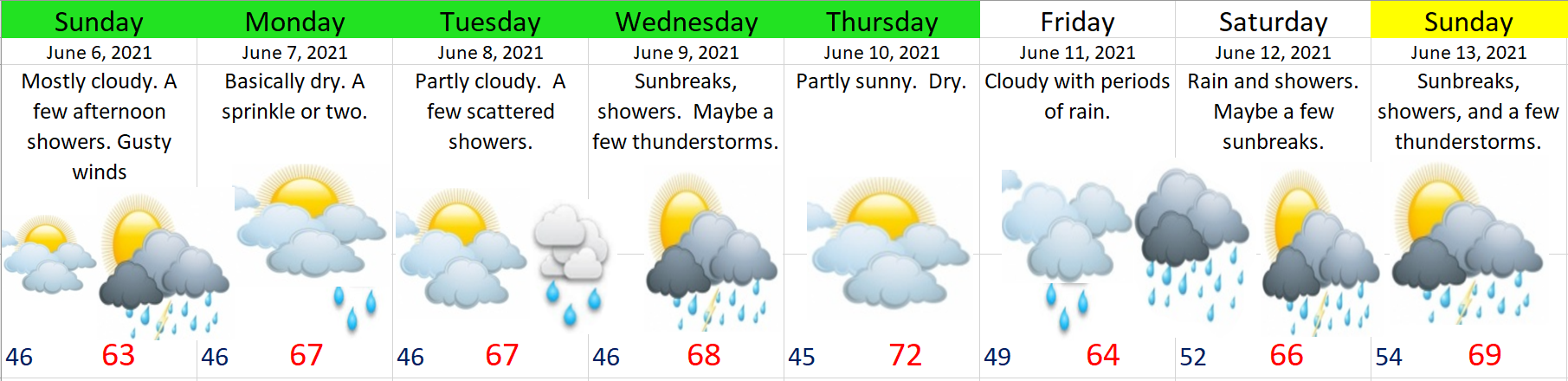
First off, today has been a great example of what “a mostly dry day” looks like. In my previous forecast I mentioned we would likely see some drizzle or a few sprinkles and to not cancel your outdoor plans, and nothing more than a few sprinkles is exactly what has happened today. Nice to see a forecast come through 🙂

Moving on I’ve noticed some really good trends in the forecast lately. Just two days ago it was looking like sprinkles would be about the best we could hope for in the coming week, but now it appears as though we will pick up much more than that.

Extended Forecast

Highlights

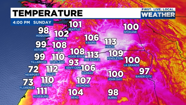
1.) Big changes in Sunday’s forecast with this storm system coming in just south enough now to clip Salem. Expect more rain further north in the Portland area while Eugene and points south should remain basically dry. Right here in Salem be on the lookout for some heavy afternoon showers along with gusty winds. Gusts over 30mph are possible. Don’t be shocked to hear some thunder with the showers either.

2.) Monday: Lots of clouds, a few sunbreaks, but really nothing more than a few sprinkles at most. Basically dry.

3.) Tuesday & Wednesday. Partly cloudy with PM showers. Showers will favor the coast, Coast Range, and the Cascades. Slight chance for a thunderstorm or two. Because the showers will be scattered in nature, there’s a chance some of you stay mostly dry these two days while others experience a brief soaking.

4.) Thursday: Partly sunny and dry. The best day of the week to be outdoors – assuming you wish to stay dry lol 😉

5.) Friday: Periods of light rain.

6.) Next weekend: Lower confidence, but as of right now, both Saturday and Sunday feature a decent chance of seeing frequent showers, and depending on the track of this system, maybe a few thunderstorms too.

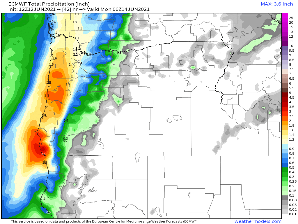
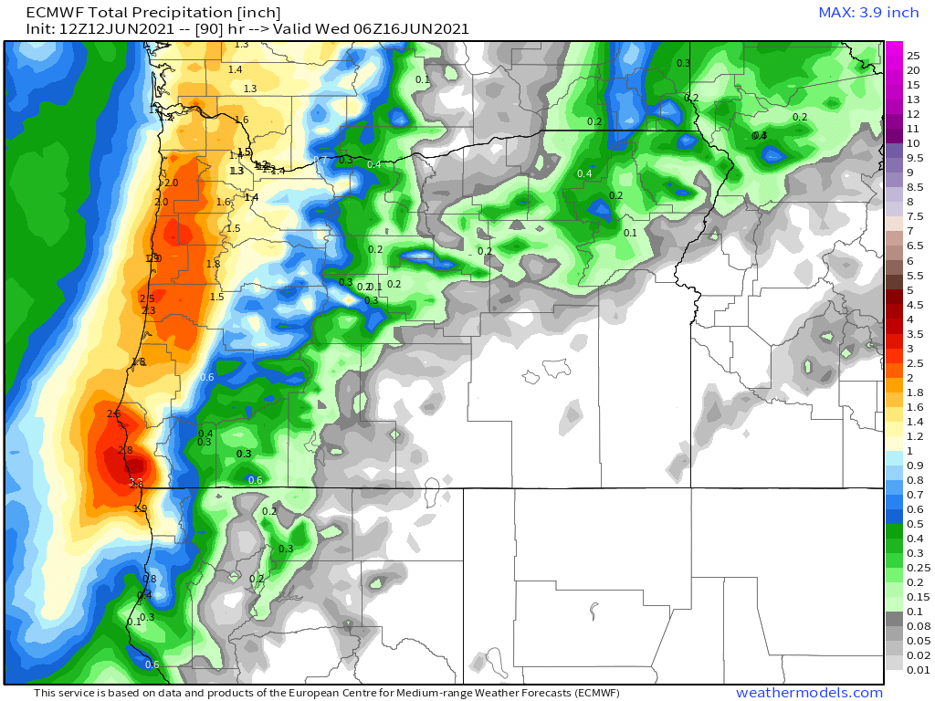
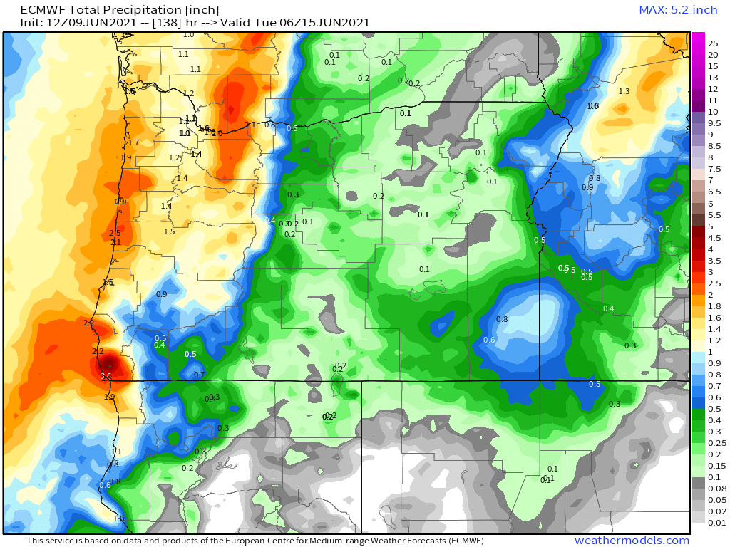
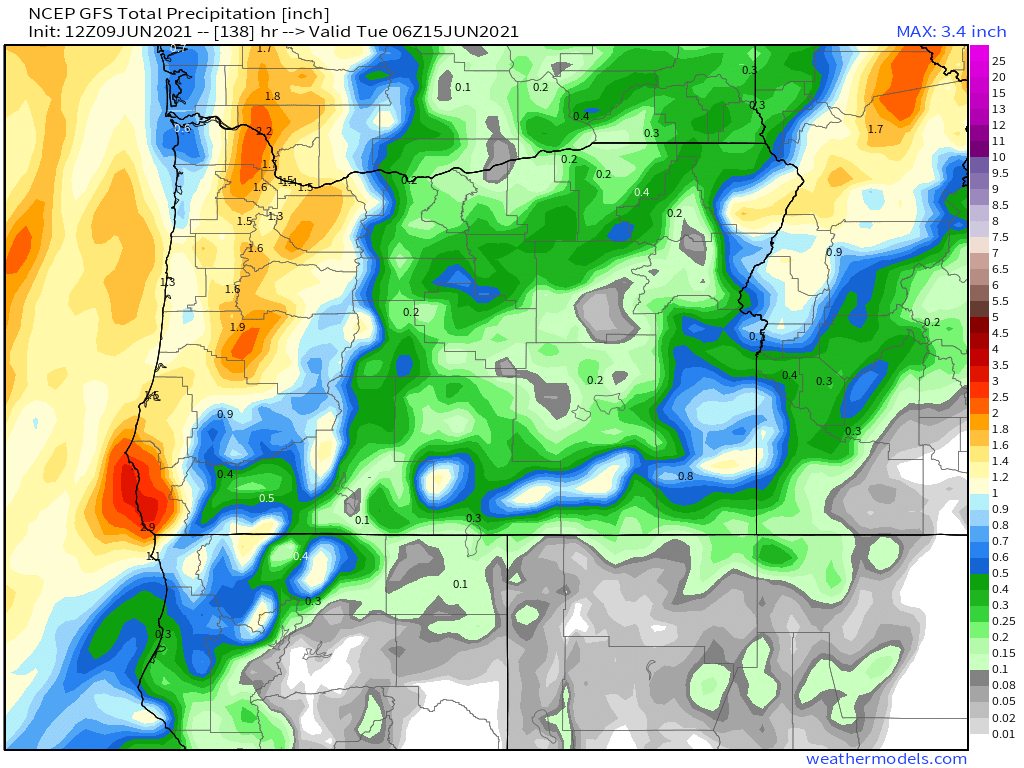
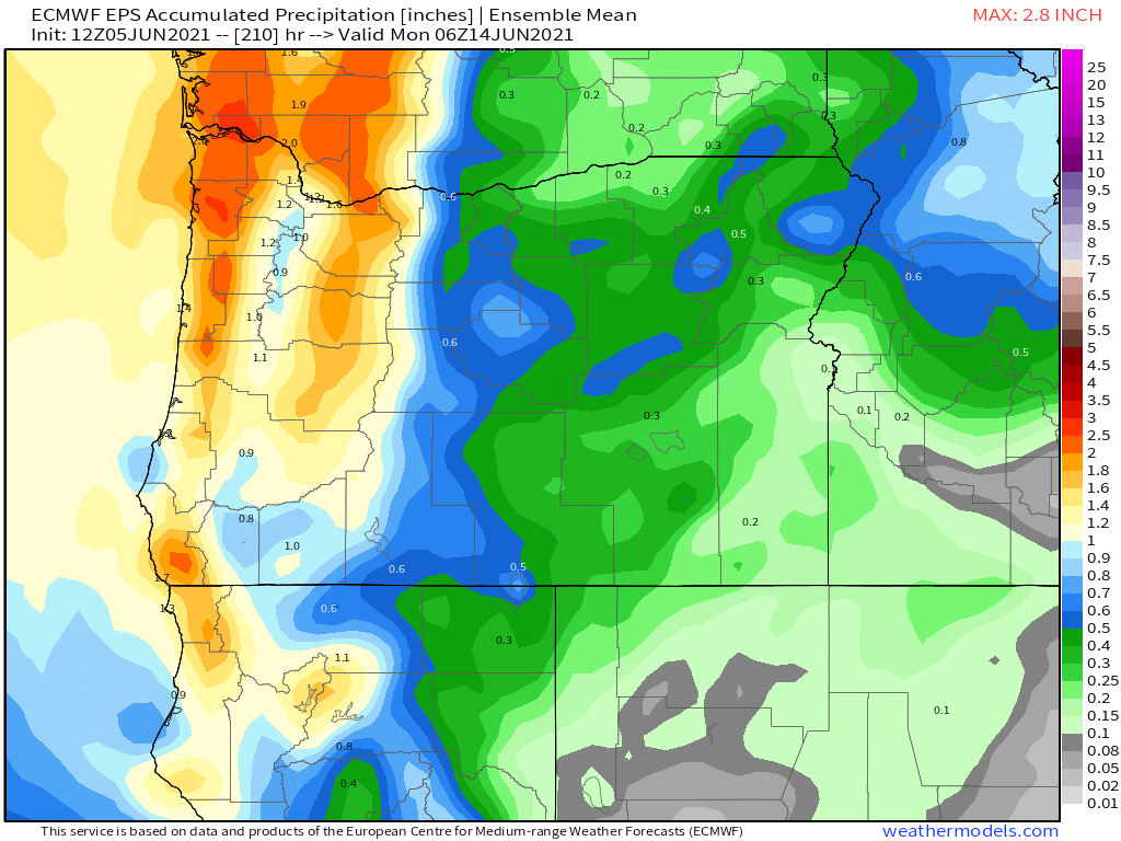
Overall the forecast has trended quite a bit wetter for both tomorrow and much of next week. The map below shows the forecasted total precip now through next Sunday.

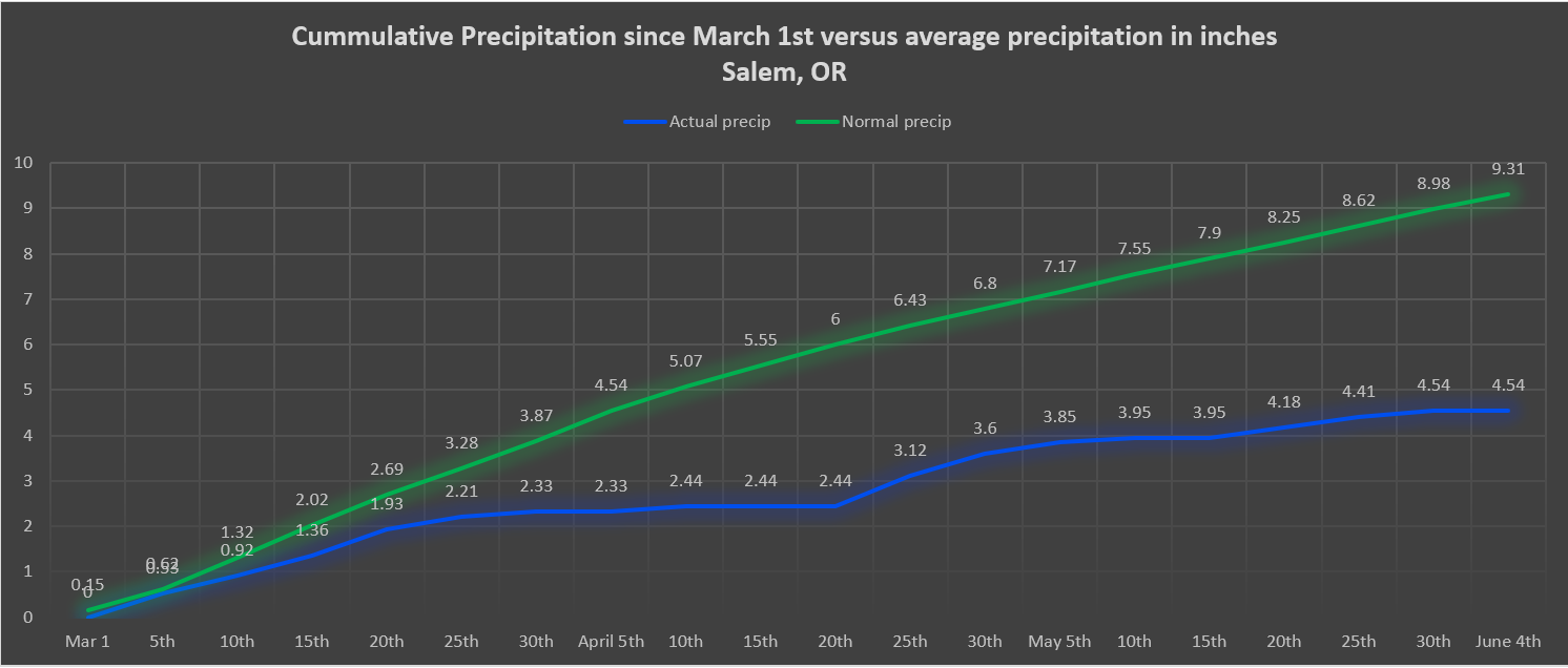
Basically if this materializes everyone here in the valley should pick up at least an inch of rain over the next 8 days with more in the mountains and along the coast. Even central and eastern Oregon should get in on the action with rain expected over there as well. This is really good news for our drought conditions, and we need it! Below is an up to date version of the map I shared a few days ago. It shows total rainfall in inches here in Salem since March 1st versus the total we should be at.

This shows we are the better part of 5 inches below normal. So yes, we do need the rain!

On a side note, one of the primary radars used to detect rain in western Oregon is down for repairs until at least Thursday. This means the little rain maps on the apps you use and some of their hour by hour forecasts may not be as accurate as usual. Just fyi and something to keep in mind. With the increase in active weather I will likely have additional updates for you in the coming days as things change.

I hope you all are having a wonderful weekend! Stay safe!