December 2020

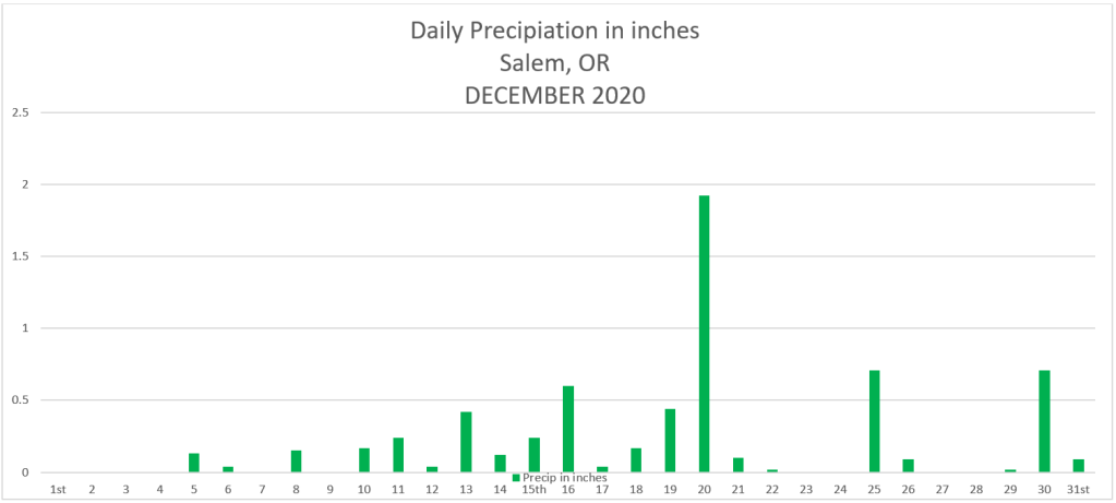
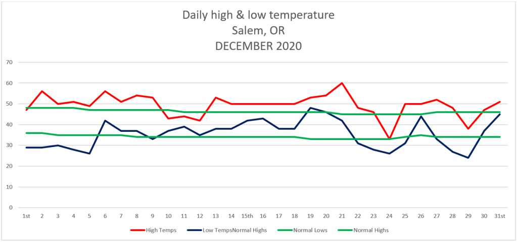
Here are the December 2020 states for Salem. We ended December slightly drier than normal with 6.45″ or 94% of average for the month. On the temperature side of things we ended up being quite a bit warmer than normal overall averaging 2.48° above normal.. Yes we had some very chilly days right around Christmas, but generally we stayed on the warmer end of things.

Warmest high temp was 60°  December 21st

Coldest high temp was 33° December 24th

Warmest low temp was 48° December 19th

Coldest low temp was 24° December 29th

11 days with temps falling at or below freezing.

21 days with measurable precipitation.

The rainstorm on the 20th brought 1.92 inches of rain to Salem (our wettest day of the month) and was probably the biggest and really the only highlight of what ended up being a rather boring month as far as weather action goes. The mountains continued to pick up just enough snowfall through the course of the month to allow for plenty of skiing opportunities over Christmas break. A huge plus for that industry.

As far as snow goes once again we went another December without any snow here in Salem. Last spring I posted these statistics showing total snowfall per month over the past 10 years for here in Salem.

Feb:  19.25″

Jan:  6.9″

Mar:  6.05″

Dec:  5.25″

Nov:  0.35″

Interesting to see how February has been our snowiest month on average over the past 10 years and how January just barely beat out March for second place. This has not historically been the case. Hard to know if this is a new norm with more snow falling during the end of winter versus the middle, or if it’s nothing more than a temporary trend. Either way one would think that sooner or later we would score a December or January snowstorm….

Looking ahead, January has already started off on a very wet note and that appears to continue. I suspect the mountain snowpack will build quite nicely too during this time.

Happy new year, and here’s to a fun, healthy, and safe 2021, and if possible a nice January snowstorm 😉 🙂
November 2020

I hope you all are enjoying the holiday season! Even with everything going on there is still much to be thankful for and much to enjoy. Just some quick words of encouragement from your local weatherman. 😉 Okay, moving on we have several dry or mostly dry days ahead with no sign of any big storms or arctic blasts, so with not much going on I figured it was a good time to recap November.

Highlights

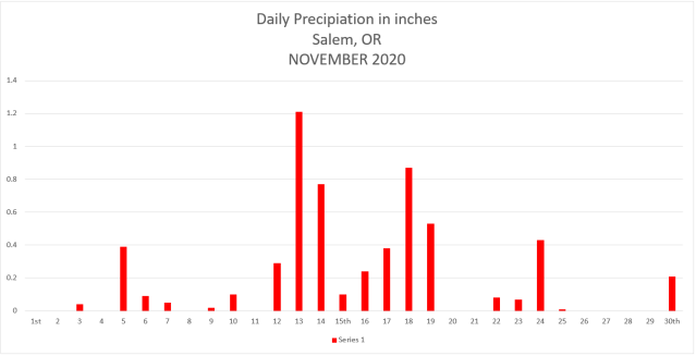
November 2020 was not real exciting in terms of weather events. We had several days of wind & rain including a peak wind gust of 43mph on the 13th, but very few really wet storm systems. Perhaps the biggest highlight of the month was the good start to the mountain snow season up in the Cascades. It’s been several years since we have seen an early start like this. As of Monday, Hoodoo had 34 inches of snow which is well above normal for the end of November!! The final thing worth noting from the month would be the higher than normal amount of dry days (both foggy and sunny) which helped to keep our precipitation for the month slightly below normal.

Temperature

Warmest high temp was 68°  November 4th   

Coldest high temp was 39°  November 27th  

Warmest low temp was 58°  November 4th

Coldest low temp was 24°  November 9th

8 days with lows at or below freezing.

It’s been awhile, but we finally had a cooler than normal month.  November 2020 was 1.1° below normal.

Salem had 19 days with measurable precipitation with most of the action taking place mid month, but as mentioned, not very many wet storm systems at all. The wettest day of the month was the 13th with 1.21” of rain.   We ended November with 5.89″ of precip which is 90% of our average for the month, so yet another drier than average month.

Looking ahead

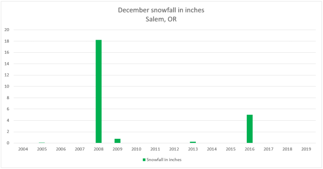
December is typically our wettest month of the year and one of our coldest. We will see what happens, but early indications are hinting at a cooler than normal month. As far as snow goes, December has not exactly been a big snow producer around here as of late. In fact, over the past decade February has actually been our snowiest month on average. Curious to see if that stays the same this year or if we get some good snowfall during December or January instead. Anyway, check out this graph of December snowfall going back to 2004.

Really only 2 years with any decent snowfall on this chart. I’m sure a lot of you remember 2008 when it snowed and snowed and snowed leading up to Christmas.  More recently in 2016 we had a nice December snowstorm, but overall December snowfall has not been all that common lately.  With that said, our chances seem to increase slightly during a La Nina.  Take it for what its’ worth, but I’m thinking we see some snow this December.  Just my gut feeling…   😉

Happy December!!!

October 2020

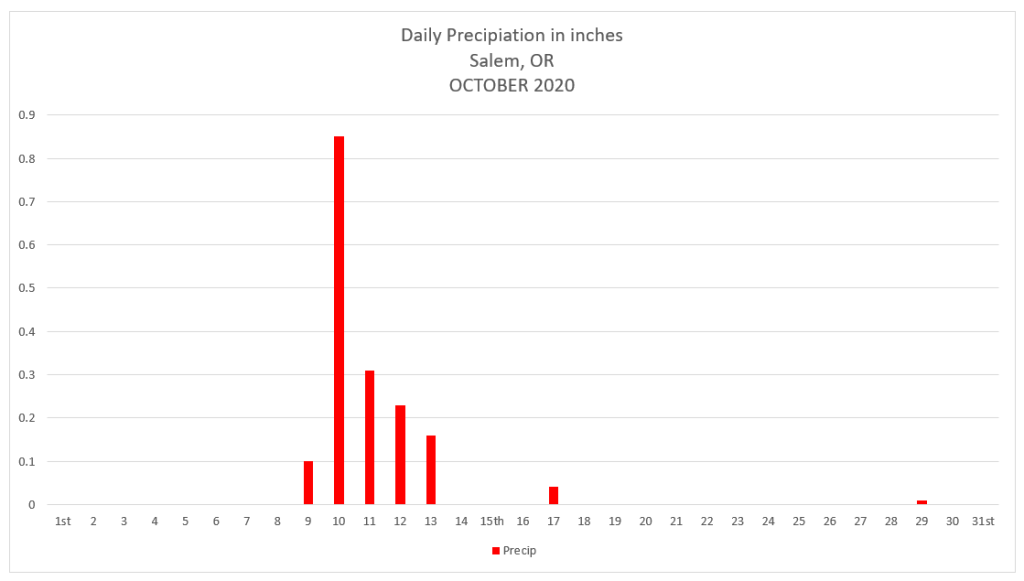
October 2020 is done. Just two months to go before 2020 is also in the bag… The highlights for the month would probably be the consistently dry weather we saw (24 dry days this month), and to a lesser extent, the couple of storms we had early in the month which brought wind gusts of 35 to 40mph.

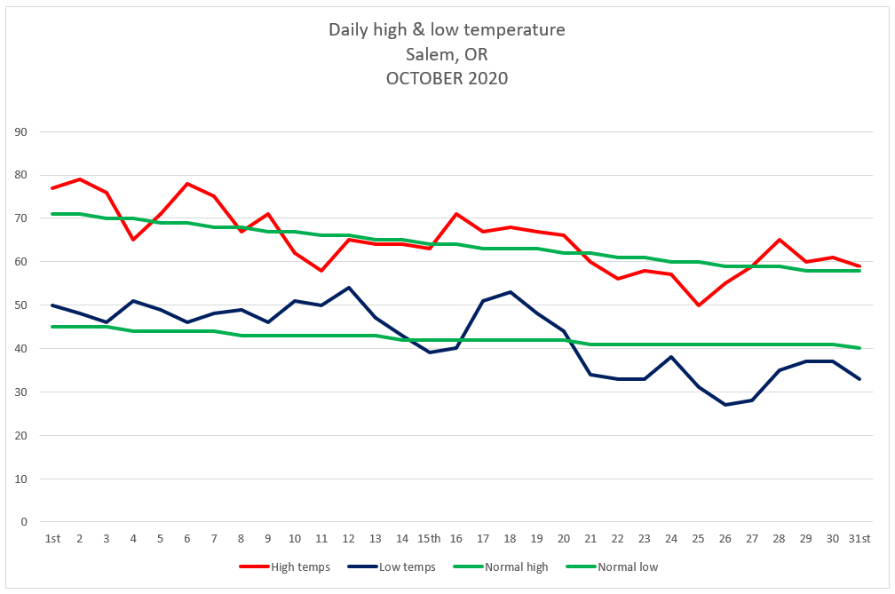
This graph shows Salem’s actual high and low temps per day along with the average high and low temps for October.

Temperature

Warmest high temp was 79°  October 2nd   

Coldest high temp was 50°  October 25th  

Warmest low temp was 54°  October 12th

Coldest low temp was 27°  October 26th

3 days with lows at or below freezing.

Precipitation

Salem saw rainfall on 7 days during October with .85” of rain falling on the 10th making that the wettest day for the month.

October 2020 Summary

Despite having a number of warmer than normal days with lots of mild afternoons, October ended at only 0.77° above average thanks to the cooler weather, and more specifically the cold mornings we experienced the last several days of the month. As far as precipitation goes, October 2020 saw only 56% of our normal precip making for a much drier than normal month.

Looking ahead

November is our first real month of our winter/storm season. It’s the second wettest month of the year beat out only by December. As far as valley snow goes, November snow is quite rare. In fact, 2010 was the last time Salem recorded sticking snow in November, and the time before that was in 2006, so perhaps one could say we are due for a little this year. 😉

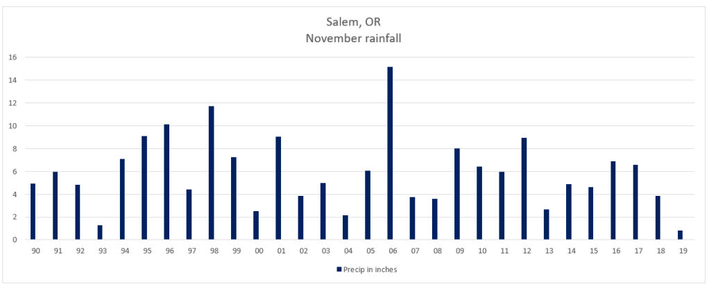
Even more overdue and more likely than November snow is a wet November. The last really wet November occurred back in 2012. Every November since then has been either right around average or drier than normal. Last November was one of the driest on record with less than one inch of rain for the entire month! I have a feeling this month will be a bit more active….

November rainfall per year for Salem, OR going back to 1990.

May 2020 and look ahead

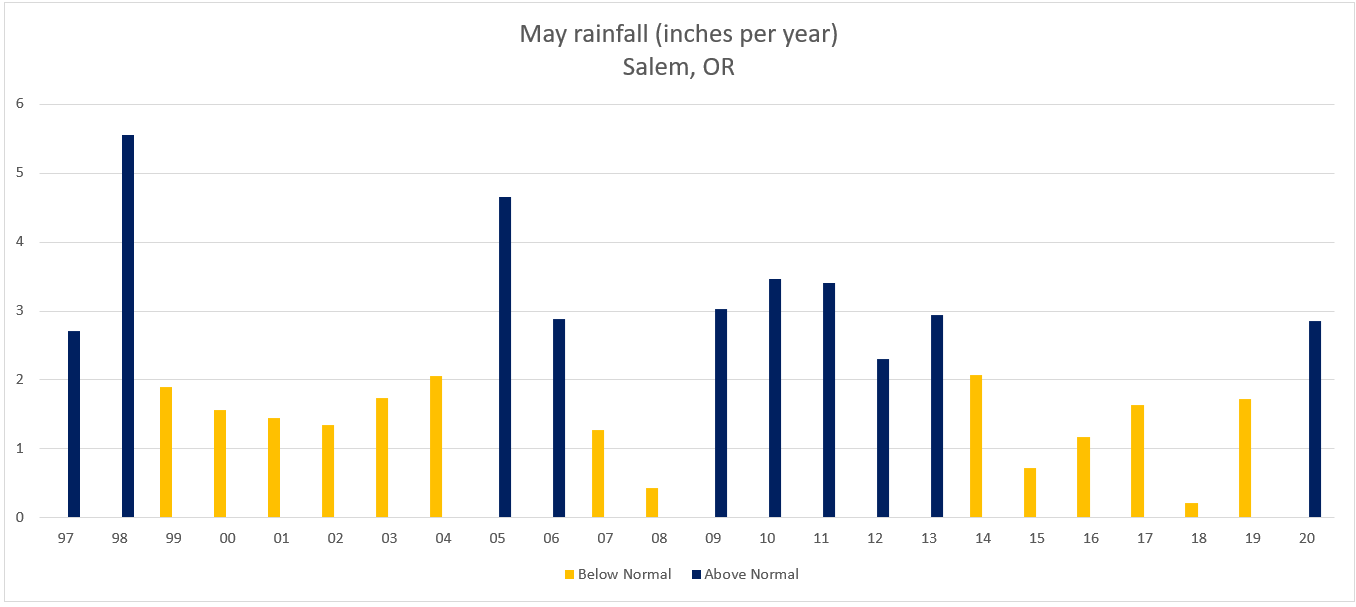
May 2020 is over and it ended up wetter than average, and despite the extra rain, Salem was still 1.6°F warmer than average for the month.  I graphed out the total May rainfall for each year going back to 1997.  The dark blue bars are years when May ended with above normal precipitation, so by process of elimination you should know what the yellow bars mean.  😉

May Salem rainfall graph

One could say that Salem was “overdue” for a wetter than average May considering our last wetter than normal May occurred back in 2013.

Look ahead

Unfortunately, I have bad news for those of us who prefer/enjoy sunny weather this time of year.  Keep in mind this week will still be mostly dry; however, it won’t be all that warm.  Nicest days this week will be Wed & Thu. 

Details 

Mon:  Basically dry with lots of clouds around.  Slight chance of a sprinkle/quick shower.  Highs in the mid – upper 60s.

Tue:  Gray and wet – especially during the afternoon.  Highs around 65°.

Wed:  Partly cloudy with highs in the mid 70s.  Very slight chance for a shower.

Thu:  Partly cloudy.  Highs around 77°.

Fri & Sat:  Showers return along with cooler temps.  Highs 63 – 67°.

Peace out and have a good week!

A quick throw back and a wild wintry weekend

Greetings!  It’s been quite some time since I last posted.  Being a first year teacher has been a wonderful experience, but it sure does take up a lot of time.  Anyway, before looking ahead to what should be an exciting weekend, I want to take a minute to review some highlights from January.  January 2020 has gone down as one of the warmest ones we have ever seen here in Salem.  The month ended 4.2 degrees above normal which is significant.  For a comparison on the other side of the scale, the cold February we had last year was 4.39 degrees below normal.

And how strange that for the 3rd year in a row we have seen a warmer than normal January only to have some sort of snow event in February or March.  2017 was the last time we had snow in January.  I’m currently working on a couple of graphs and I’m not finished with the data yet, but it appears as though February has been a snowier month than January during this past decade.  Interesting don’t you think???

Now onto something I think you will find far more interesting – we have a chance for snow now through Sunday night.  Details below:

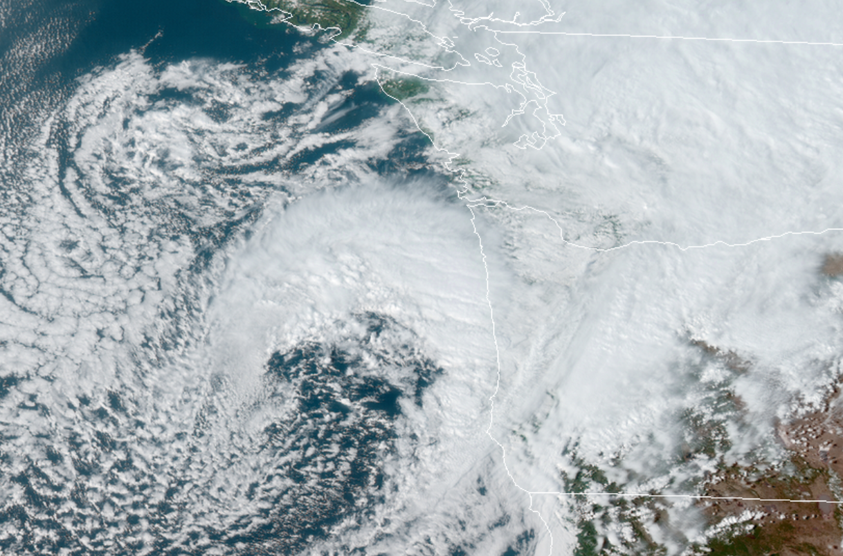
Tonight through Saturday morning:  Here’s what the satellite from around 4:40pm looked like.  You can see a nice comma shaped storm off the Oregon coast.  This sucker is going to send moisture over us tonight while pulling in cold air in through the Gorge.  If things come together just right there is no reason why anyone couldn’t wake up tomorrow morning to a coating of snow.  Lows around 32 degrees.

March 13.20

Saturday:  I expect snow showers (maybe some ice pellets and rain mixed in during the afternoon) on and off through the day.  Sunbreaks at times should help “warm” us up into the low 40s.

Saturday night – Sunday morning:  Similar to tonight’s weather only colder and slightly drier which means anyone could see a dusting of snow.

Forecast Summary

I like our odds for seeing a little bit of snow (better than anything we have seen this winter), but around here even when the odds are good it’s still not a slam dunk.  Finally, like the vast majority of our snow events this one is very marginal.  We could easily end up with nothing, or things could come together just right for a “surprise” 2 or 3 inches.  It’s the weekend, and there is no school next week which means I’ll be on top of this storm with updates should things change.

I’m personally hoping for snow as it would be a nice break from all this virus stuff going on, plus who doesn’t like a good snow event???

You can use this link to track the satellite:

https://rammb-slider.cira.colostate.edu/?sat=goes-17&z=3&im=12&ts=1&st=0&et=0&speed=80&motion=loop&map=1&lat=0&opacity%5B0%5D=1&hidden%5B0%5D=0&pause=0&slider=-1&hide_controls=0&mouse_draw=0&follow_feature=0&follow_hide=0&s=rammb-slider&sec=conus&p%5B0%5D=geocolor&x=6725&y=2674

Click on this image from Mark Nelson’s weather page to see the regional temps:

Have a fantastic evening!!!!!!!!!!!!!!!!