Wet week in review and a look ahead

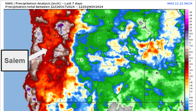
As promised, this week has been very winter like with lots of rain, chilly temperatures, and at times, gusty winds. Below is a county map of Oregon showing total rainfall over the past 7 days. Most of the Willamette Valley has picked up around 3 inches of rain since last Saturday!

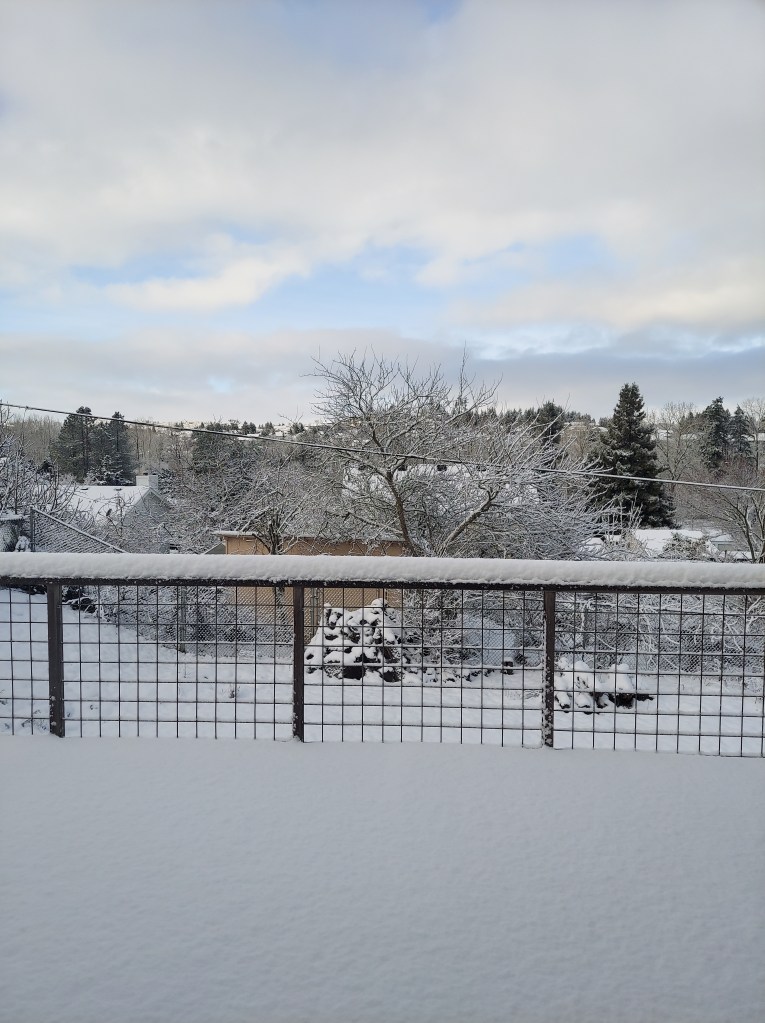
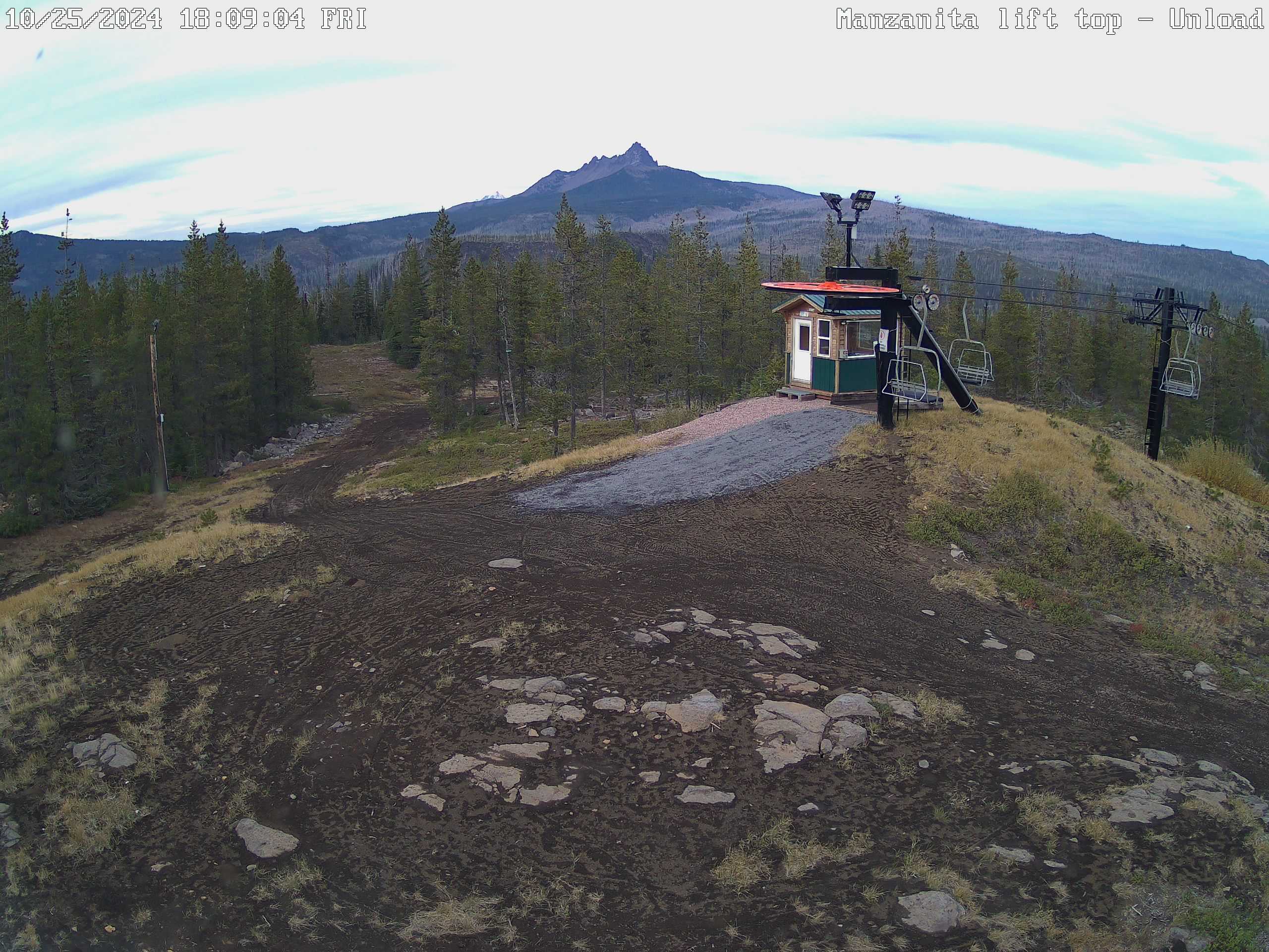
The other big change over the past week has been the well advertised increase in mountain snow. Hoodoo had a 15 inch base early this afternoon with 4 to 8 inches of new snow expected this evening through Sunday morning.

Looking ahead

Tonight: Showers increasing through the evening. Lows tonight in the mid 40s.

Sunday: Mostly dry with some a little bit of sun, and only a slight chance of a shower. Highs into the upper 50s.

Monday: Rain returns as a quick moving cold front sweeps in from the northwest. PM sunbreaks and showers. Highs in the mid to upper 50s.

Tuesday (Election Day): Highs around 57° with a fair amount of sunbreaks, and a slight chance for a brief shower or two.

Wed – Fri: Lots of fog. This time of year can be incredibly foggy, especially after having so much rain. Expect widespread fog each of these three days. Lows will likely bottom out in the 35 to 38° range and highs 49 to near 50 degrees assuming we get some afternoon sunbreaks. Lows could dip to freezing for areas that receive a little more clearing at night.

Next weekend: Rain appears likely, but obviously subject to change being several days out.

No big storms on the horizon at this time, and nothing real out of the ordinary for early November. No signs of any big warm rainstorms to wash away our early snowpack either as temperatures remain a little cooler than normal in the coming days.

October 2024

October may have ended on a cooler note, but overall it was quite mild being 2.8 degrees warmer than normal. As far as precipitation goes, we finished the month above average with a total of 3.8″ to kick off our new water year. Average for October is 3.47″. Over 2 inches of that rain fell during the final week of the month.

Have a great and safe rest of your weekend!

Soggy weather update and April in review

What a soggy and wet weekend we just had. Salem has picked up nearly two inches of rain between Friday and Sunday, and actually Salem set a new rainfall record back on Saturday for the most rain recorded on that date with a full inch falling just on that day alone.

My previous forecast for Monday and Tuesday remain on track with Monday standing the best chance for thundershowers and big downpours, and Tuesday standing the best chance for some dry weather. We dry out and warm up for the remainder of the week. More on that at the end of this post.

April 2024

April 2024 was a drier month, but with almost perfectly average temperatures. Nothing really exciting happened. We had our usual brief downpours of heavy rain and in some instances – hail, but that is to be expected, and it was far less than we have seen in past Aprils. In the end we had just 60% of our average total precipitation for the month. For temperatures, we ended -0.1° cooler than average, so basically right on the dot. Salem did have a late season freeze on April 17th the official airport temperature reading recorded a low of 32°. Our warmest temp of the month was a high of 75 degrees which took place both on April 2nd and April 23rd.

Thunderstorm info and look ahead

Things to watch for in the coming months include thunderstorm threats, heatwaves, the annual end of our spring showers and storms, and the beginning of our extremely stable warm and dry summertime pattern.

I do have a fun thunderstorm chart for you all which is curtesy of Mark Nelson over at Fox 12 Oregon. It’s true we don’t see very many thunderstorms in the Willamette Valley, and when we do experience them it’s often times a quick rumble or two and nothing more. Despite that, we do have a thunderstorm season here, and this chart below illustrates those seasons (circled on here) by showing the percentage of years lighting was observed in Multnomah County for any given hour of the year per week. For example, 7% of the years analyzed had lighting in Multnomah County during the 9pm hour in the first week of February. Check it out and click for a larger view.

As you can see, there are two distinct thunderstorm seasons here – albeit not very impressive seasons when compared to say Arizona or Florida. Nonetheless, we are currently in our peak thunderstorm season, and will be through most of June.

A second thing which caught my eye is the slight uptick in lightning occurrences during the overnight hours in summer. Salem’s best shot at nighttime lightning goes from roughly July 1st through the first week of September and you can see that represented on the chart.

I’m definitely curious and a little excited (as always) to see how much – if any thunderstorm action we get over the rest of this spring and summer season. Right now we have a shot at some brief thundershower action Monday, and maybe Tuesday before drying out and warming up with no rain or thunderstorm threats afterwards for at least several days. I’ve upped our high temperatures for Friday and Saturday with daytime temps reaching 83 to 85°. Highs on Sunday should still be back into the low 80s. The dry weather should dominate most of next week as well, but if any rain threats pop up I should have adequate time to inform you all.

Have a great Monday, stay safe, and keep an eye out for any lightning you might be lucky enough to spot. 🙂

November 2022 and the weekend

The forecast

Periods of rain and breezy conditions will prevail through Sunday. This is typical northwestern Oregon rain. Nothing real wild.

Temperatures will stay chilly though which means the incredibly healthy Cascade snowpack will continue to grow. Check out this image showing our current water equivalent snowpack percentages by region.

The entire state is running well above normal for early December. Hoodoo Ski Area currently has 42″ of snow at its base. I was just up in the Cascades last weekend and I can attest to the fact that there is a lot of snow up there already. The storms this weekend will dump another 18 to 24 inches of snow through Sunday night. Snow levels will also stay below the passes the vast majority of the time, so expect snow covered roads if you’re heading up there.

Next week is going to be cold. No clear signs of moisture interacting with the cold yet; however, this will almost certainly be the coldest weather we have seen this winter. I’m watching things closely for sure! 🙂

November 2022

November stood in stark contrast to the extremely warm weather we saw in October. Check out this comparison between October and November for temperature departures from normal.

Highlights from the month include the little bit of wet snow which fell on the evening of the 6th. Slushy accumulations of less than an inch were reported in the higher hills south of Salem as well as areas near Corvallis.

The wettest day of the entire month actually took place just two days prior on the 4th with 1.65″ of rain falling in just 24 hours.

For almost 3 weeks nothing really happened through the majority of the month other than it was freezing cold, and dry.

The month closed out with a bang as a strong cold front moved through. Salem recorded a wind gust of 44mph and picked up another inch and a half of rain while the mountains received a couple feet of snow. For you guys who enjoy statistics, here’s a quick recap of November 2022.

That’s all for now. Have a fantastic weekend and stay safe out there!

Our Extremely warm fall

I admit I’m stating the obvious when I tell you that our fall season so far has been both extremely warm and dry; however, the part which sticks out the most is the warmth. We have been in record setting territory, but does this mean we might have a warm and mild fall/winter season too, or is there any correlation at all? We’ll take a look in this post. If you’re hoping for a forecast I can tell you that basically it’s looking dry for at least the next 7 or 8 days, so nothing new or exciting, and sadly nothing to really help put out the fires which continue to burn across the PNW.

This past September ended up 3 degrees above normal with only .29″ of rain (just 20% of normal) making for an extremely dry month! In addition to that, September 2022 also recorded seventeen 80+ degree days making the past month feel like an extension of summer. Look at how warm the western half of the country was during September.

Much of the western U.S. was 3 to 5° for the month.

October has also started out extremely warm with 6 out of the first 10 days reaching the 80 degree mark vaulting Salem to 6 degrees above normal for the month! Here’s the temperature anomaly map for the month so far:

The entire state of Oregon and Washington are currently running 6 to 10 degrees warmer than normal for October.

What’s really bizarre though is we have seen years in the past with extremely warm and dry Septembers and even Octobers during La Nina conditions only to flip to stormy weather. Currently we are experiencing (for a third year in a row) La Nina conditions – something to keep in mind.

Let’s look at September 1974. It was a La Nina year and a mere .28″ of rainfall for the entire month which is almost identical to the amount we saw this September. September 1974 was also extremely warm with a whopping 21 days above 80 and 11 days at/above 90°!

So what happened in 1974 after such a warm and dry early fall? Well over 14 inches of rain fell in November and December alone coupled with tons of mountain snow. Let’s look at a few more examples.

Exactly one year later in 1975 (La Nina year), Salem recorded its driest September on record. Not a single drop of rain fell the entire month. It was also very warm with eighteen 80+ degree days. The second half of October through December brought over 16 inches of rain though, and even some pre Christmas snowfall.

How about one more example? September 1998 was very dry as well with only 0.68″ of precip and plenty of mild days to boot. The following November and December dumped 20 inches of rain here in Salem resulting in widespread flooding. Worth noting that this was also a La Nina winter…

Bottom line is a warm and dry first half of fall can easily switch to a very wet, cool, and stormy second half. To be honest, that’s exactly what I expect will happen this year within the next 2 weeks. Watch for updates as the rainy season draws near and enjoy the warm and dry weather while it lasts, because it won’t last for much longer. Winter and the rainy season is coming, it’s just taking it’s sweet sweet time to arrive, but remember this post and know that you’ve been warned. It is coming…. It won’t be long before everything is all soggy, puddles everywhere, the rivers flowing high, and we will start wishing for sun again.

January 2022

January was a bipolar month with extremely wet conditions the first 7 days before abruptly switching to a mostly dry pattern for the remainder of the month. 3.71″ of rain fell in just the first week, but less than an inch fell in the remaining 24 days of the month.

January 2022 started off with a major rain and mountain snow storm January 3rd. This storm brought 2.34″ of rain in only 24 hours to Salem causing local flooding along creeks and on some streets. Heavy snow fell with this storm in both the Coast Range and the Cascades where nearly 3 feet of snow accumulated. The Willamette River in Salem topped out at 22.12′ which was the highest level in a few years. Flooding was extremely minor though and was limited to some parks and a few rural areas.

Things calmed down and stayed calm the rest of the month. Overall it was an incredibly “boring” month with very little weather action.

The only other highlight worth mentioning was the number of days with very chilly mornings. Salem reached the freezing mark 13 days in January. The coldest temp occurred on the 29th with a frosty low of 23°. Our warmest temp was 60° on the 12th.

Precip ended at 4.5″ which is 74% of normal making for a drier than average month. January 2022 ended just 0.1° above normal which is basically as close to average as you can get. Both the really chilly nights and the “mild” afternoons all balanced out quite well to give us an average month.

Looking ahead

So far February has been extremely tame and calm as well. We will be dry through Sunday (at least) with highs approaching 60 degrees several days later on this week and into the weekend. Of course this is nice for being outdoors, but terrible for the snowpack, and it only makes the continuing drought conditions worse than they already were. We really need a wet and cool second half of February and March to make up for the lost ground. The cooler weather in January helped preserve the snowpack fairly well despite the lack of precip, but I noticed more areas are beginning to slip below the 100% mark, and with mild temperatures in the forecast and no additional mountain snow coming for at least the next 7 days, these numbers will only drop more.

No need to freak out yet, but if we need to see a pattern change fairly soon…

That’s the scoop on January 2022.

Enjoy your evening and take care!

December 2021

It was a wild ride through December. I’ve got a timeline of the major events followed by a look at how we stacked up in the precip and temp departments.

Believe it or not, we had a high of 65° the very first day of the month. This image from Fox 12 Oregon shows a compilation of just some of the record high temps set on December 1st.

Nothing else interesting happened the first 10 days of December. We gradually cooled down and the snowpack very slowly began to build. Then on the 11th and 12th a powerful storm rolled in bringing gusty winds (a peak gust of 47mph to Salem), heavy rain, and mountain snow – tons of it. Within 4 days Hoodoo went from just a few inches of snow to almost 40!! Snow also fell down into the Coast Range.

Heavy rain showers lasted through the 13th. Skies cleared up and temps dropped quickly that night leading to widespread black ice Tuesday morning (the 14th). Many area schools had a 2 hour delay that day due to the icy roads. The picture below shows fresh snowfall up at Mount Hood after the storm had passed.

A second powerful and extremely dynamic storm system moved in on the 18th. Heavy precip on the cold side of the front dragged the snow level down to the valley floor in the Portland metro area dropping a couple of slushy inches of snow. Salem missed out on the snow and saw nothing more than a cold rain for this storm. Heavy rain continued through the 20th with a grand total of 4.78″ of rain in only 3 days! Lots of localized flooding along ditches, small streams and creeks.

Cold and snow dominated the final 8 days of the month. A storm system dropped straight down from Canada bringing with it cold temperatures and snow showers. Neighborhoods around Salem picked up anywhere from 5 to 10 inches over a 3 day span. This cold snap gave Salem 4 days in a row with highs only reaching the 30s. A couple of pictures of the snow cover over at Western Oregon University in Monmouth and some neighborhoods in Salem.

A heavy snow shower rolls through Independence Oregon Dec 26th, 2021.

Salem ended the month with 9.90″ of precip which is well above our average rainfall for December. This made it one of the rainiest Decembers in years coming in at 142% of normal for the month! This map shows total precip in inches for December across the region.

From looking at this you can see it was a great month for the entire west coast in terms of rainfall/precip. The graphic below shows just how far our snowpack came over the month of December.

Our warmest temp for the month was 65° on the 1st, and our coldest temp was 26° on the 31st. Salem only dropped to or below freezing 6 days this month even with the cold snap. Overall we ended December 2021 just 0.8° above average.

That officially wraps up December 2021. It was wild, but we made it! Things have really calmed down for now and they look to stay calm for the foreseeable future. Expect a small chance for just a couple of light rain showers both Tue & Wed. Thursday could end up being a little bit wetter during the morning hours, but then we dry out for Friday through at least next Monday. No sign of any big storms or snowy/icy weather.

Extremely mild and November 2021 recap

The second half of October and the first half of November were both quite stormy and active with several small to moderate wind events, plenty of rain, and mountain snow. Since then it has basically been a blowtorch around here. November 2021 ended up being 3.5° above normal which is fairly significant. We still managed to dip below freezing once on the 21st with a low of 30°, but overall it was quite mild with 9 days reaching at least 60°! In the precip category we came up a little bit short despite the very rainy and wet start to the month. 5.50″ was our grand total for the month which is 92% of the monthly average.

November is actually one of the months which became slightly drier when the new averages were updated this past year. Between 1980 and 2010 the normal rainfall for Salem during the month of November was 6.5″. When the 1980s were dropped and the 2010s were added, our average rainfall for November dropped by a little more than half an inch down to 5.95″. Meanwhile, both March and October have turned wetter over the past decade. Interesting don’t you think? The maps below show the changes in average precip for each of these months.

Total Salem rainfall for November going back to 1990.

1995, 1999, 2008, and 2016 all had really mild Novembers as well with temps very similar to what we have seen this year. All 4 of these years were also La Nina winters, and 3 of the 4 years listed ended up delivering at least one good snowstorm here in Salem. I’m sure some of you remember all the snow we had before Christmas in 2008, and then the winter of 2016/2017 had several snow events too, so a warm November does not at all mean a warm winter. It doesn’t guarantee a cold one either, but don’t be too worried about the lack of cold or mountain snow just yet. In fact weather maps are indicating this may be the last week of mild weather for quite some time, so get out there and enjoy it! 🙂

Quick forecast and look ahead

1.) Mild weather continues through Sunday; although today will likely be the last 60 degree day – finally…

2.) A few sprinkles are possible both Thursday and Saturday, but honestly it won’t amount to hardly anything.

3.) The nice weather ends Monday as a significant storm system rolls in bringing a good amount of rain. This storm will be the first of several storms bringing multiple rounds of showers, rain, and mountain snow for the rest of next week.