Our first heat wave

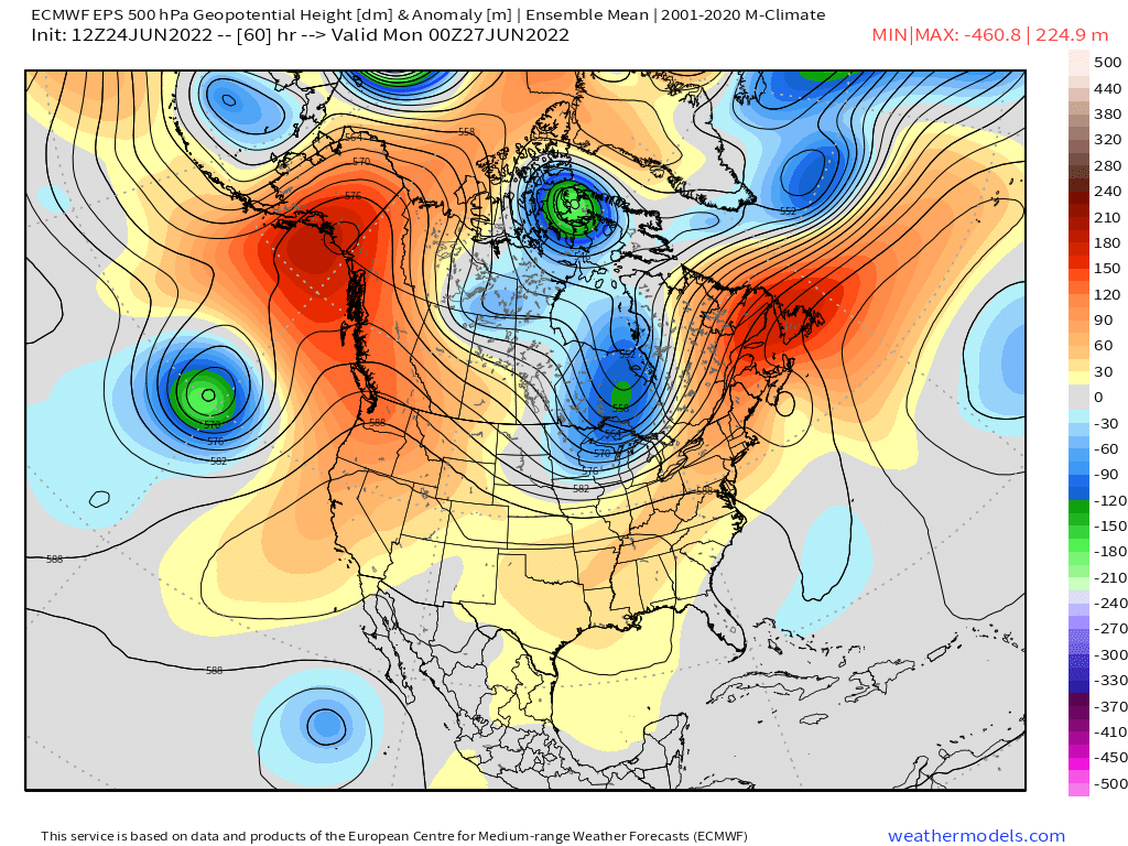
So far summer 2022 has started off much slower than last summer, but we are finally going to see things change (briefly) as a dome of hot air builds up towards us from the desert southwest. You can see the dome of heat is pretty much right over the Pacific Northwest by Sunday. The map below essentially shows temperature anomalies up around 18 thousand feet in the atmosphere.

Here’s what I’m expecting:

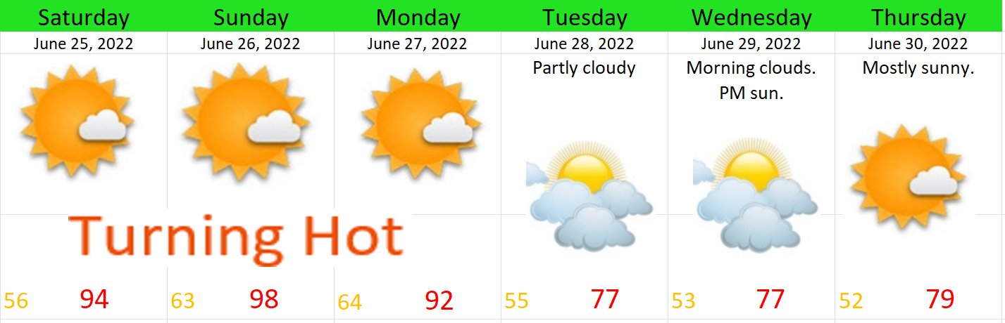
This will be a very typical heatwave with temps spiking close to 100° on Sunday before cooling back down on Tuesday. In fact, most of next week will stay close to average. No sign of any long term hot spells like we’ve seen far too often over the past several summers.

A question I’ve been getting is “will Oregon see a wet summer?” Based off of long range maps, my very best guess is yes, probabilities seem to favor a “wetter” summer. Problem is, this statement can be very misleading and here’s why. Take July for example, on average Salem only sees rainfall between 1 and 2 days each July which means 3 rainy days technically equals a wetter than normal July by that metric. However, if you do the math, this still leaves us with 28 days or 4 full weeks of totally dry weather for the month, so can we really just call 3 rainy days a “wet month?” My answer there is no. If you want to know what a truly wet month looks like then think back to April or last December lol. Hopefully my point is coming across here okay… To help illustrate this further, check out this chart showing total rainfall in Salem for July going back to 1970.

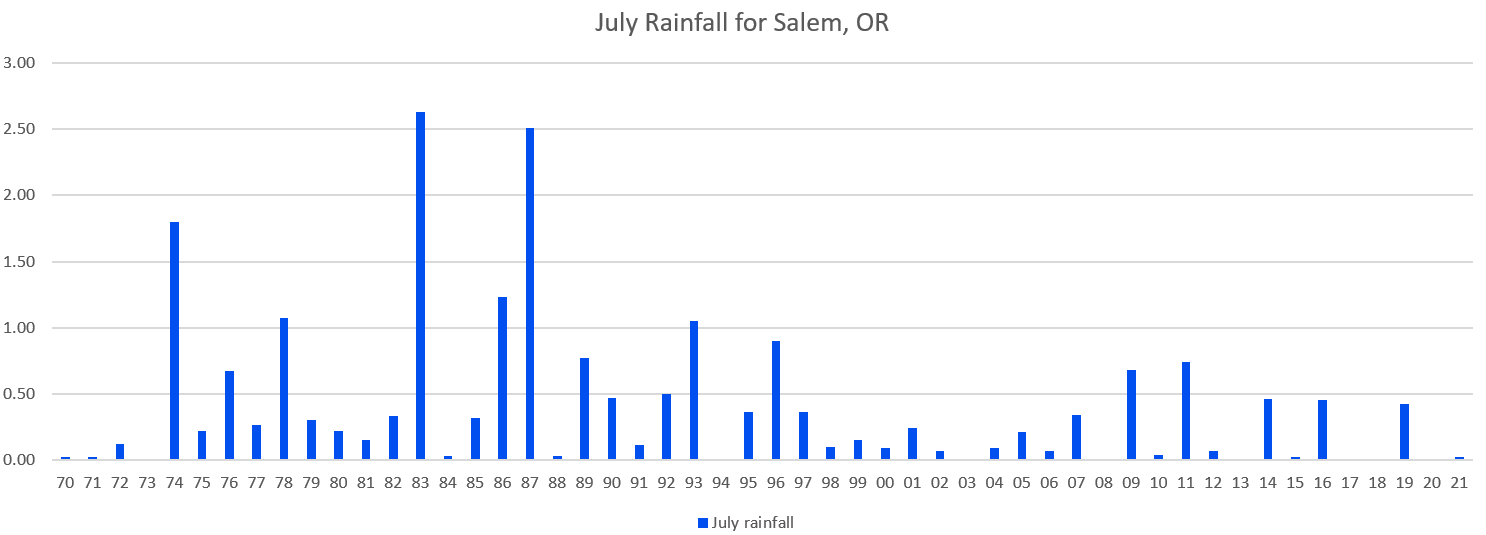
For the record, the average rainfall for July is just under half an inch. 1993 is the last time we saw more than an inch of rain in July. Goes to show just how reliably dry this month is for us. If we do manage to receive half an inch of rain this July, it will make it the wettest one in 11 years!! Similar story for August and the first half of September too. Our summers are reliably dry and that’s what I like about our climate. It’s so awesome having a 2 – 3 month period of warm mostly dry weather for getting outdoors.

Bottom line is, it doesn’t take much rainfall to make it a “wetter than normal summer” around here. Long range charts do show the potential for rain and showers sometime between July 4th and July 7th. Poor timing if it interferes with Independence Day celebrations, but we should quickly return to dry summer like weather afterwards as we head further into the month.

My best guess is this will not be one of those summers where we go nearly 2 months without any rain as we have seen many times in the past decade. I expect showers will pop up a few times through the next couple of months; however, just remember that should we see showers, the warm, sunny, and dry days will still far outnumber the “wet” days.

I will keep a close eye out for any rain chances, but unless we have more big heatwaves or a rare summertime rainstorm (or thunderstorm outbreak) on the horizon, I probably won’t be posting a whole lot as this is our quiet time of year – not to mention it’s the one time of year I get to recharge before heading back into the classroom. 😉 🙂

Have a wonderful weekend.

Be careful and be kind to each other. 🙂

Tame and mild January

After an active December and first few days of January, the weather has really really slowed down. Tame and uneventful weather looks to continue for the next 2 weeks! There is no sign whatsoever of any cold or snowy weather, nor is there any sign of a big rain or wind storm. This image showing 24 hour rain totals illustrates this calm weather pattern quite well.

As you can see, no big rainstorms in sight.

What you can expect over the next 2 weeks:

Now through Monday: Mostly sunny and dry. A few clouds here and there, maybe some patchy fog, but totally dry. Highs 48 – 52° and lows in the low to mid 30s.

Tuesday – Thursday of next week will feature a few light showers. Enough to wet everything down a bit, but nothing more than that. These will all be very weak systems with no real impact on our daily lives.

Next Friday through much of the following week will be mostly dry, lots of sun with highs in the upper 40s to low 50s, and lows in the low to mid 30s still. Like I said, very uneventful, and extremely tame.

What does this calm weather mean for the rest of winter? Well nobody can know for sure; however, I looked back at previous La Nina winters that also had slow/tame weather in January, and just about all of those years had big switches back to cooler and wetter weather in both February and March. So, I would say we are far from done with winter here. Sea surface temperature anomalies also indicate that both La Nina and the cold pool of water south of Alaska (both of which affect our weather) are still going strong. These areas of cooler water show up very well on this map.

There you have it. Calm and fairly “mild” weather will rule the day for the foreseeable future. Enjoy it while it lasts because history tells us February often times brings much different weather to our region…

Extended forecast

There are multiple items peaking my interest this evening on the weather models. I have forecast details below including an update on the Cascades. Here’s our 7 day forecast for all of us visual people first. 😉

Details and Highlights

1.) Chilly showers tonight through Friday evening with snow levels dipping close to 1000′. Could see some ice pellets and or wet snow mixing in with the heavier showers.

2.) A powerful storm is set to move in on Saturday. Saturday will be a complete washout all day long. Winds will be strong during the early morning hours with gusts around 40 to 45mph. This storm will have quite the impact across the region with even stronger winds on the coast Friday night and Saturday morning (gusts up to 65mph), plus heavy mountain snow, and heavy rain in the lowlands. Expect some really terrible travel conditions this weekend.

3.) Very low snow levels Monday – Thursday of next week with several storm systems rotating through the region all while cool air is in place. What is certain is the Cascades are going to get hammered with a ton of snow. I’m fairly confident the Coast Range will see a quite a bit of snow as well.

4.) Notice I don’t have any snowflakes on the forecast yet. Right now I’m thinking it will be a little too “warm” for snow next week with the snow level staying above 1000′, but watch for new updates in case anything changes.

5.) Watch for black ice on roads this coming week as we flirt with below freezing temperatures, especially if we have some clearing during the nights.

The Cascades

There was absolutely no snow at Hoodoo Tuesday afternoon. Mount Hood had a little in the upper most elevations, but all of this is just now beginning to change. First off, checkout just how awful our current snowpack is. As of Dec 6th the entire state was running way behind in the snow department. Fortunately, it is very early in the winter season, and as I mentioned things are changing.

Now look at how much snow is expected to fall between now and Monday night.

Some 40 – 50 inches of snow up on the mountains in only 5 days!! That is a significant amount of snow in a fairly short timeframe. Travel across the mountain passes looks terrible this weekend, so use extreme caution if you find yourself headed that way.

This parade of storms will bring much needed rain to both Oregon and California – even southern California. Meanwhile, the Sierra Nevada will see feet and feet of snow along with many of the mountain ranges out west. Overall a wonderful pattern for building the snowpack, restoring groundwater, and replenishing the drought stricken regions out here in the western US. This map shows snowfall for the entire west coast now through Wednesday.

The downside to this will be the adverse impacts on travel. I suspect we will hear of highway closures in the coming week as heavy snow blankets the mountain passes across the region. This will effect travel and the delivery of goods – another reason I am all about staying prepared with food and supplies at home. Okay, have a great evening, and keep an eye out for more updates as the weather is looking to stay active!

Extremely mild and November 2021 recap

The second half of October and the first half of November were both quite stormy and active with several small to moderate wind events, plenty of rain, and mountain snow. Since then it has basically been a blowtorch around here. November 2021 ended up being 3.5° above normal which is fairly significant. We still managed to dip below freezing once on the 21st with a low of 30°, but overall it was quite mild with 9 days reaching at least 60°! In the precip category we came up a little bit short despite the very rainy and wet start to the month. 5.50″ was our grand total for the month which is 92% of the monthly average.

November is actually one of the months which became slightly drier when the new averages were updated this past year. Between 1980 and 2010 the normal rainfall for Salem during the month of November was 6.5″. When the 1980s were dropped and the 2010s were added, our average rainfall for November dropped by a little more than half an inch down to 5.95″. Meanwhile, both March and October have turned wetter over the past decade. Interesting don’t you think? The maps below show the changes in average precip for each of these months.

Total Salem rainfall for November going back to 1990.

1995, 1999, 2008, and 2016 all had really mild Novembers as well with temps very similar to what we have seen this year. All 4 of these years were also La Nina winters, and 3 of the 4 years listed ended up delivering at least one good snowstorm here in Salem. I’m sure some of you remember all the snow we had before Christmas in 2008, and then the winter of 2016/2017 had several snow events too, so a warm November does not at all mean a warm winter. It doesn’t guarantee a cold one either, but don’t be too worried about the lack of cold or mountain snow just yet. In fact weather maps are indicating this may be the last week of mild weather for quite some time, so get out there and enjoy it! 🙂

Quick forecast and look ahead

1.) Mild weather continues through Sunday; although today will likely be the last 60 degree day – finally…

2.) A few sprinkles are possible both Thursday and Saturday, but honestly it won’t amount to hardly anything.

3.) The nice weather ends Monday as a significant storm system rolls in bringing a good amount of rain. This storm will be the first of several storms bringing multiple rounds of showers, rain, and mountain snow for the rest of next week.

October 2021

This past October was odd in a few ways. Salem received rainfall 18 days this October; however, the vast majority of that rain was not heavy enough to give us a “wet month.” We ended up with 78% of our normal rainfall at 2.71″.

As far as temperature goes, it was a near average October. at 0.3° below normal. There was no widespread freeze this month with our coldest temp only being 35° on the 12th. We have had some cold October weather in recent years, but not this year. There were no significant warm spells either. In fact, our warmest temp was just 73° on the 3rd.

On October 24th and 25th a powerful low pressure spun up several hundred miles offshore. There were no historic impacts right here as it was several hundred miles away; however, the storm still brought some locally heavy rain and a solid 24 hours of south/southwest winds which gusted between 30 and 45mph right here in Salem. This lead to some power outages and a few downed tree branches and limbs. Massive waves were also common along the coast during this storm. Below is an image from Mark Nelson over at Fox12 Oregon. It shows the strength and path of both “bomb cyclones” which effected the Pacific Northwest. Had the storms moved up the coast “inside” (east) of the red line then we would have seen significant damage, so I guess you could say we dodged a couple of big bullets with these two storms.

Satellite image of the first big storm on the 21st.

SUMMARY

All in all it was a fairly typical October with a mostly dry first half, and then the rainy season showed up right on cue the second half of the month. Those two big cyclone storms were hands down the highlights of this month otherwise nothing too crazy.

2021/2022 Winter Outlook

If you’ve been outside at all over the past couple weeks then you know it’s definitely that time of year again. Time to take a peak into what our winter weather season might have in store for us. My “forecast” for this coming winter is more of a statistics based outlook than an actual forecast. I looked at and reviewed past years which had similar sea surface temperatures and similar weather patterns to make my prediction. Years with similarities are called analog years. Based off of analog years (years with similar conditions), current forecasts, and recent sea surface temperature trends, it seems clear we will experience a La Nina this winter.

What is La Nina, and what are the effects here in Oregon? In short, La Nina is a cooling of the sea surface temperatures in the Pacific Ocean off the coast of South America. I used arrows in the the image below to highlight that cooling. I also pointed out the cooling south of Alaska as this too can directly effect our weather.

Basically you can count on a La Nina winter being active with more weather action taking place than in a typical winter. The primary impacts being wetter than normal, cooler than normal, a good mountain snowpack, higher chance for major flooding, and increased chances for valley snow. Let’s break those down in detail.

1.) WETTER THAN NORMAL Perhaps the number one thing which stands out to me is how wet La Nina winters typically are in the valley. All 9 analog years I reviewed in detail gave Salem either near average or above average precip. This lends pretty solid confidence we will end up with a fairly wet/rainy winter with plenty of rain and mountain snow which is great news for our ground water and drought conditions. As is the case every winter, Salem should still see a number of dry days mixed in. The key thing to remember is that overall between now and March we have a higher chance of ending up wetter than average.

2.) SOLID MOUNTAIN SNOWPACK Odds significantly favor an above normal mountain snowpack this year which is great news for skiers/snowboarders and very good for our water supply with a solid above average snowpack occurring in all 9 analog years! One caveat is a few of these analog years got off to a slow start in the snow department meaning Nov and Dec weren’t necessarily real good in terms of mountain snow; however, all of the years analyzed ended up with an excellent second half of the ski season as snow ramped up nicely in Jan and Feb. Bottom line is whether it starts early or takes its time, a good mountain snowpack this winter is a safe bet. This image from Mark Nelson over at Fox 12 Oregon does not include last winter’s La Nina; however, the point seems clear that La Nina winters tend to bring really good snowfall totals to our mountains which is why I’m feeling confident we see a good mountain snow season this year.

3.) FLOODING  This next one is not good news. Keep in mind I’m strictly talking odds here by looking at what happened in past La Nina winters, but for this one the odds are not in our favor. Of the 9 years surveyed, 5 saw a notable (either moderate or major) valley flooding event. The percentage of La Nina years with significant flooding events is high when compared to non La Nina winters. Below is a list of historic flood events on the Willamette River in Salem. This list only contains floods occurring since flood control dams were built in the 50s. It’s no coincidence 10 of Salem’s 13 worse floods occurred in La Nina winters, and it makes sense. It’s a natural consequence of having lots of mountain snow and more rain than normal. So while it’s far from certain, one would be wise to keep this in the back of their mind as the odds of seeing some sort of flooding event this year are higher than normal.

4.) COOLER THAN NORMAL 8 of the analog years ended up as either average or cooler than average. Basically don’t expect a “mild” winter.

5.) VALLEY SNOW  Perhaps the most anticipated question is whether or not it’s going to snow here in the valley. Well, all 9 analog winters produced at least some snow here in Salem. 😉 Breaking it down further this is where it gets tricky. 5 of the 9 analog winters I reviewed in detail gave Salem a legit snowstorm with several inches of snow. The other 4 only saw minor accumulations of a slushy inch or so which is not really enough to enjoy in my humble opinion. So take it for what you want, but odds are quite high we at least get a dusting of snow at some point this year, and more importantly, odds are somewhat higher than normal we see a respectable sized snowstorm this winter bringing us several inches of snow. Far from a slam dunk as I like to say, and we are talking statistics, but it does provide some extra hope for us snow lovers.

So yes, may the odds be ever in our favor. Here’s a quick recap for you:

1.) Odds favor a wetter and stormier than normal winter overall.

2.) Odds favor a good mountain snowpack and good year for ski resorts.

3.) Increased odds for a significant valley flooding event.

4.)  Cooler than normal weather (overall) is likely.

5.) Higher than normal odds for a more significant snow event here in the valley.

The odds definitely favor a more active winter, but only time will tell, so be ready for anything. If you have been reading my posts over the past year then you know I’ve really hit hard the idea of having supplies on hand at home for when a disaster strikes. Look at the severe impact Covid-19, last year’s wildfires, and the major ice storm all had on our community. You want to be prepared. For example, even if you don’t live in a flood plain it’s still a good idea to be ready for a major flood as such an event would likely effect the supply chains to our local stores. Something to think about.

Okay, I’ve laid it all out there. I really hope you all have a nice fall and winter season. I personally really enjoy the extra time with family and friends fall and winter brings along with the holidays and festive activities which accompany this time of year. Focus this season on what is important in your life and enjoy the people around you God has placed in your life. Regardless of what happens weather wise I enjoy being your forecaster and and I hope it’s a safe, enjoyable, and fun season for you all!!