I figured it was time to bring back the monthly reports. These are definitely a fun way of documenting the month just in general as well as highlighting any major weather events from the month. If you are looking for the forecast then skip down to the bottom. 😉
September 2021 Summary
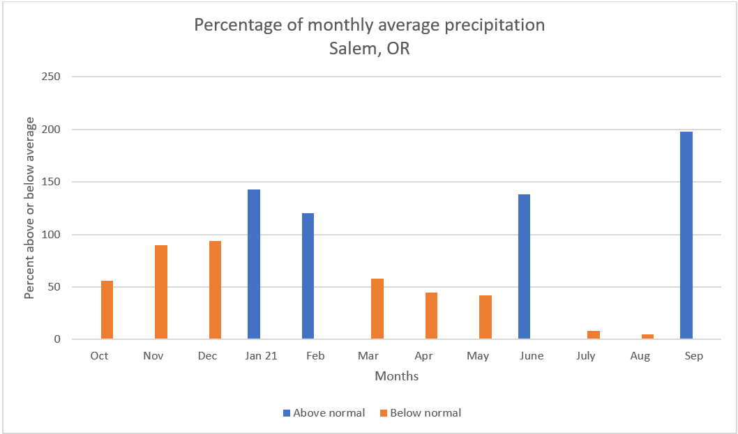
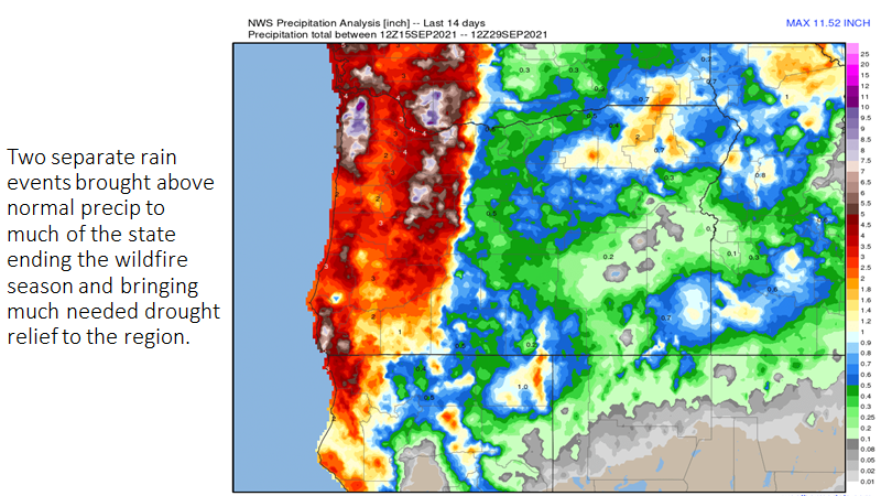
Much of September 2021 was actually very warm and summer like which is common for September; however, a few good soakings during the second half of the month gave Salem a rainfall total of 2.89″ which is a whopping 198% of our monthly average! This chart below shows the percentage of total precip for each month here in Salem going back to last October.
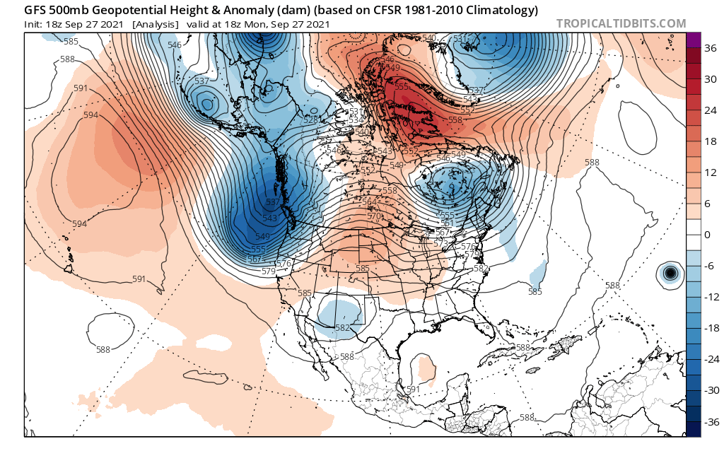
This image above shows the upper level pattern which brought Salem steady rain on the 27th.
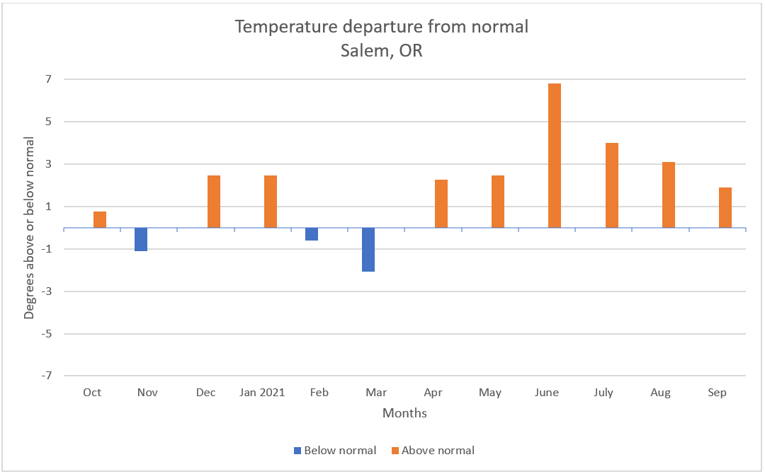
At 1.9° above normal, September ended up being Salem’s 6th warmer than average month in a row in what has been a fairly warm year. This chart shows the number of degrees above or below normal each month has been since last October.
Looking ahead
October is off to a fairly cool and dry start. As of today (Saturday), Salem is sitting at 3.7°F below normal for the month, but with only .19″ of rain. From looking at the long range charts, it seems obvious the cooler weather is here to stay.
FORECAST HIGHLIGHTS
1.) Sunday’s going to be a typical shower and sunbreak type of day with small hail and brief downpours possible. Very cool air with this storm will bring a few inches of snow to the Cascades Sun night and Monday morning.
2.) Plan on Monday being mostly dry with just a very slight chance of a PM shower. The cool airmass behind this system will set us up for our coldest lows of the year Tuesday morning with frost in some of the outlying areas around the valley.
3.) A weak storm system moves though Tuesday night and Wednesday bringing a few showers here and there, but nothing big.
4.) Besides the nice weather we are seeing today, next Tue, Thu, Fri, and Sat all look dry for outdoor projects and adventures. No sign of any late season warmth to go with that dry weather unfortunately as we seem to be locked into a cooler pattern for the foreseeable future.
This past summer has been a “blockbuster” with numerous records set. In addition to seeing the hottest temperature ever recorded two days in a row back in June, we’ve also seen record warm low temps, the highest number of 100+ degree days ever recorded in a single year, and on top of that, a record number of 90+ degree days!! It’s truly been a historic and extremely hot summer. In fact the June, July, August period will go down as Salem’s hottest summer since records began in the late 1800s!
June will be remembered for the historic and record breaking heatwave which took place at the end of the month; however, it was hot even earlier in the month as well with near record high temps occurring on June 1st.
The heat continued through the month with several more 90+ degree days before the big heatwave hit. Here were the temperatures at 4PM that Sunday. Incredible heat for this region!
Then even hotter high temps the very next day before cool marine air rushed in from the southwest.
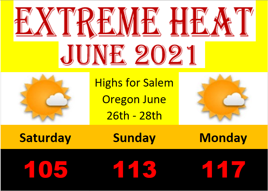
After the heatwave I shared this graphic to help document the historic heatwave.
The heat continued through July and the first half of August with Salem hitting 103° on the 11th and 12th. When all was said and done by mid September, Salem had recorded an astonishing 41 days at or above 90 including 6 days at or above 100° which is also a new record! Nothing like that in any other year!
It was a hot one, and it was dry. This was the US drought monitor map for Oregon as of September 7th before the rains started.
Believe it or not the wildfire season was nearly as bad as it could have been, nor was it as bad as some predictions suggested with around 290,616 acres burned so far versus the 1.1 million acres burned in 2020. A big improvement!
There are many reasons for this drop, but perhaps the biggest two reasons, okay three reasons were: A very inactive thunderstorm season. A lack of lightning strikes significantly reduced the amount of fires started especially east of the Cascades. Two, we had just enough pushes of cooler marine air and even a couple shots of light rain in July and August which helped conditions west of the Cascades. The third reason was the lack of a strong east wind event like we saw last year in September. All in all it was a dodged bullet if you ask me. Goes to show that drought conditions, snowpack levels, and the weather conditions in spring are not nearly as important as what actually takes place during the summer and wildfire season. Something everyone should keep in mind for in the future.
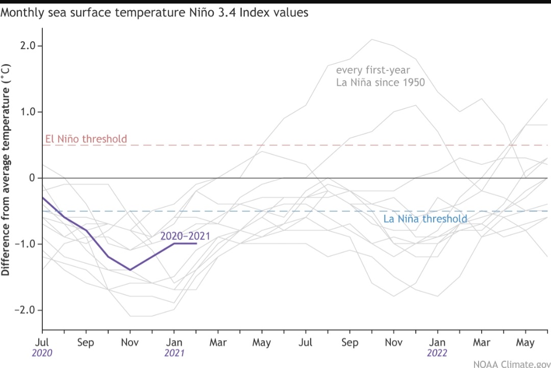
There you have it, summer 2021. Switching gears I’ll have a fresh forecast Sunday plus I’m currently working on my winter outlook. With a La Nina on tap and looking at the current sea surface temperatures & overall weather trends it appears we have a good shot at seeing a very wet & active fall/winter season…. More on that in the coming week.
Number 1.) The sizzling hot start to the month. Salem set a new record for June 1st with a high of 97°! The heat didn’t last long before we cooled off quite a bit. Then the rain came…
Number 2.) After such a dry spring we finally saw a good soaking with 1 to 2 inches of rain falling between June 11th – 15th. Our wettest stretch of days since the February ice storm.
Number 3.) June 2021 hands down will be known for the insanely hot heatwave near the end of the month which brought record shattering high temperatures three days in a row.
Those high temps were 27, 35, and an incredible 39° above our usual highs for those three days!! Truly remarkable. Here were the high temps across the entire region from Monday (June 28th).
You can see the sharp cutoff in temps out along the coast. Of course this was the day we had that 40 to 45 degree drop in temperature in a matter of hours as the cool ocean air finally flooded the valley ending our unprecedented heatwave.
There are three things which really made this heatwave historic. The first is (of course) the insanely hot temps. Prior to this event Salem had never in recorded history been above 108°. We blew through the record on Sunday with a high of 113 and then we blew through that new record the very next day with a high of 117!!
The warm nights were also a major aspect of this heatwave. Salem’s low temp Monday morning was 76° and there were parts of the Portland metro that never fell below 80° that night. YIKES!!! The warm starts to the days allowed us to warm up quickly which leads me to the third and final aspect of this heatwave and that was the duration of the heat.
The length of time it was hot each day added to the oppressiveness of the heat. Temps topped 90 degrees by 8AM on Monday! I’ve never seen that here before ever… Typically on a really hot day we reach 100 degrees right around 3:30 or 4PM and will stay there for just a couple of hours at most. This time though we experienced 100 degree weather for much longer all three days. For example, on Sunday many valley locations were above 100 degrees for 7 to 8 hours.
June 2021 Summary
Overall we ended the month an astonishing 6.67° above normal!!! An incredibly hot month with 10 days above 90 and of course our three back to back to back 100 plus degree days. We just lived through one of the hottest months on record! I imagine you all (like myself) are tired of these “once in a lifetime” weather events. In less than a year we have had a historic fire and smoke disaster, a historic ice storm – which left many people without power for days and even weeks, a historically dry spring, and now a historic heatwave. Leaves us wondering what the next “historic” weather event here will be as we seem to be on a roll unfortunately….
What’s funny and odd is how June 2021 ended up being a wetter than normal month. Yes! I know it may not seem like that could be possible, but if you recall we had 5 very wet days right in a row earlier in June putting us at 1.72″ (138% of normal for the month). Goes to show how statistics can be misleading. Everyone will remember this month, and rightfully so, for the intense and historic heat, but few will recall that for the first time since February we had an above/wetter than normal month.
Forecast
Tuesday will be hot with highs in the low 90s.
Wed & Thu will be the nicest and coolest days of the week with AM clouds both days and highs only around 80 or 81°.
Fri & Sat will be hot again as we climb back into the mid 90s!
Next week should feature more typical summer weather with lots of 80s. Still no sign of any rainfall.
First off I would like to recognize the brief, but major heatwave we just experienced. Very rare to see temps so hot this early in the season. Check out the scorching high temperatures we experienced on Tuesday. Lots of new records!
Another nice little graphic I’m borrowing from Fox 12 Oregon showing some of the new records set around the region this past Tuesday.
A significant warm spell for so early in the season, and for those of us who work either outdoors or in buildings with no AC it has been a brutal few days!
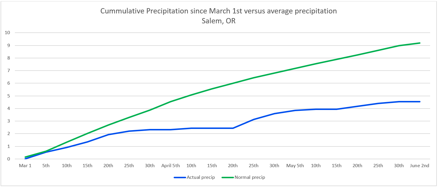
Moving on, let’s recap May 2021. Some things just don’t change with yet another very dry month here in Salem. A lack of significant rainfall kept us at 42% of our normal precip for the month (.94 inches). We also ended on the warmer side of things at 2.48° above normal. In the meteorological community, the official spring season is from March 1st through May 31st. This spring will go down as the 8th driest on record here in Salem!
Below is a graph I made showing total rainfall since March started (the blue line) versus our normal cumulative rainfall (the green line). It’s easy to see that since March begun we have fallen further and further behind normal, and until we get some significant rainfall, this gap will continue to grow.
Unless we have a crazy wet summer, our drought conditions will only continue to worsen. Again, keep in mind a drought does not equal or guarantee a bad fire season, but it definitely helps set the stage for one. As much as it kills me to say this, hopefully we can manage a few summertime soakings to help minimize the fire threat.
Extended Forecast
Not a whole lot to report on. We do have some much cooler weather on tap for Saturday through most of next week. We even have a chance for some really light rain/drizzle Saturday.
Main points to know:
Light rain/drizzle is possible Saturday, but don’t let it stop you from going outdoors. This will not be a washout type of day at all. Wetter up in the both the Coast Range and Cascades though if your plans take you there…
No sign of a rainy or real wet day at all. Sure we will see a few sprinkles, but nothing which will really make a dent in our drought.
Most of next week will be cool with highs in the low to mid 70s and lows dipping back down into the upper 40s at night!
No sign of another heatwave anytime soon…
Take care, stay safe, and have a fantastic rest of your week!!
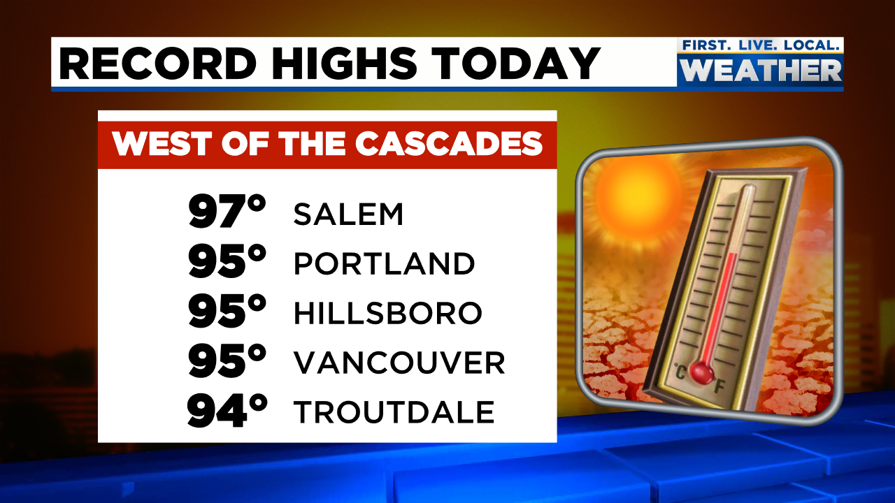
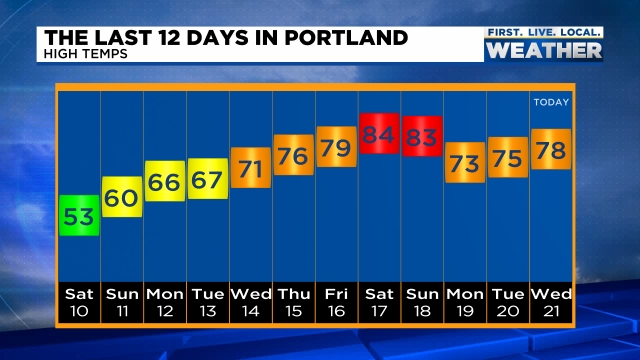
Interesting month so far. We started the month off with some very chilly – even record cold low temperatures, but wow how it has switched and turned around! We just had an incredible stretch of warm April weather with a new record high occurring this past Saturday with a high of 85° – a whopping 24 degrees above normal!!! This graphic from Mark Nelson with Fox 12 Oregon shows high temps in Portland and gives a good visual of our accent from very chilly weather earlier in the month to the record warmth we recently experienced.
The other record we are currently working on is a record dry April. Do you realize we have only picked up 5% of our typical rainfall for this point in the month? We are running way behind average! I have some good news though as rain looks to arrive this weekend. Okay, so rain on the weekend is not necessarily the best timing lol, but we need the rain; otherwise it’s going to be one heck of a summer.
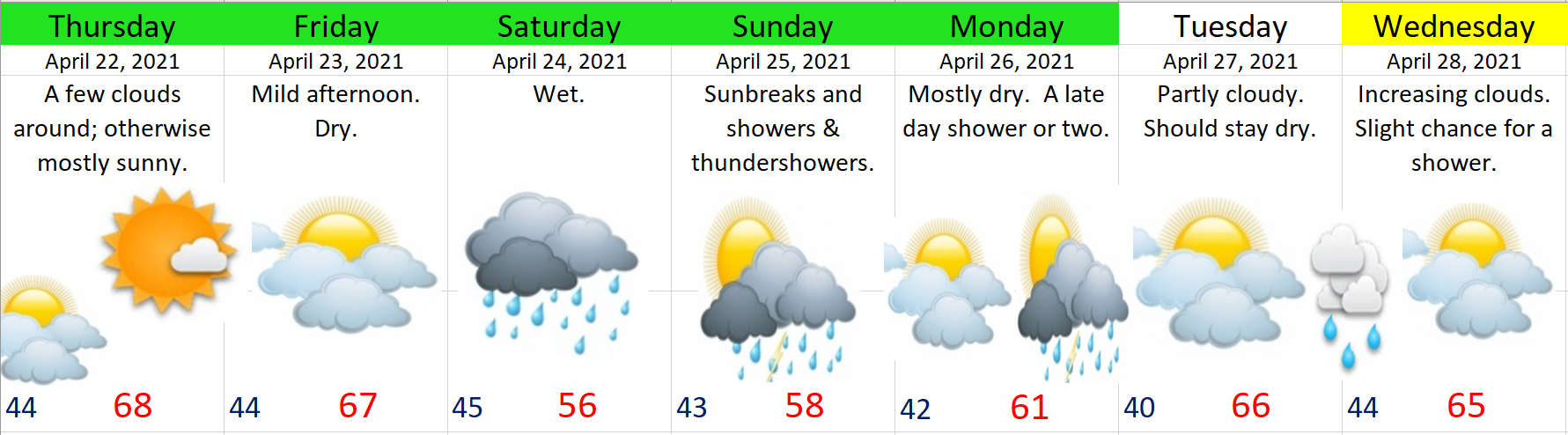
The next 7 days and forecast highlights
Basically rain continues on and off through much of next week, so hopefully we make up some of that deficit.
The wettest days will be Saturday and Sunday. We do have a shot at seeing a few thundershowers on Sunday. Monday should be mostly dry with showers late in the day, and as it stands now, Tuesday looks to be a fairly dry.
There you have it. Have a great rest of your work week and stay safe!
The sunshine outside is making it feel like a distant memory, but it doesn’t change the fact that we have seen some really chilly nighttime lows (for April) lately. Sunday morning Salem tied its record low of 29°! This nice graphic from The National Weather Service in Portland shows how record lows were widespread this morning across western Oregon.
Despite having a few mild afternoons (our average high this time of year is 60°), Salem is actually running1.8 degrees below normal for the month thanks to these very cold morning lows. Change is coming this week as much warmer weather moves in.
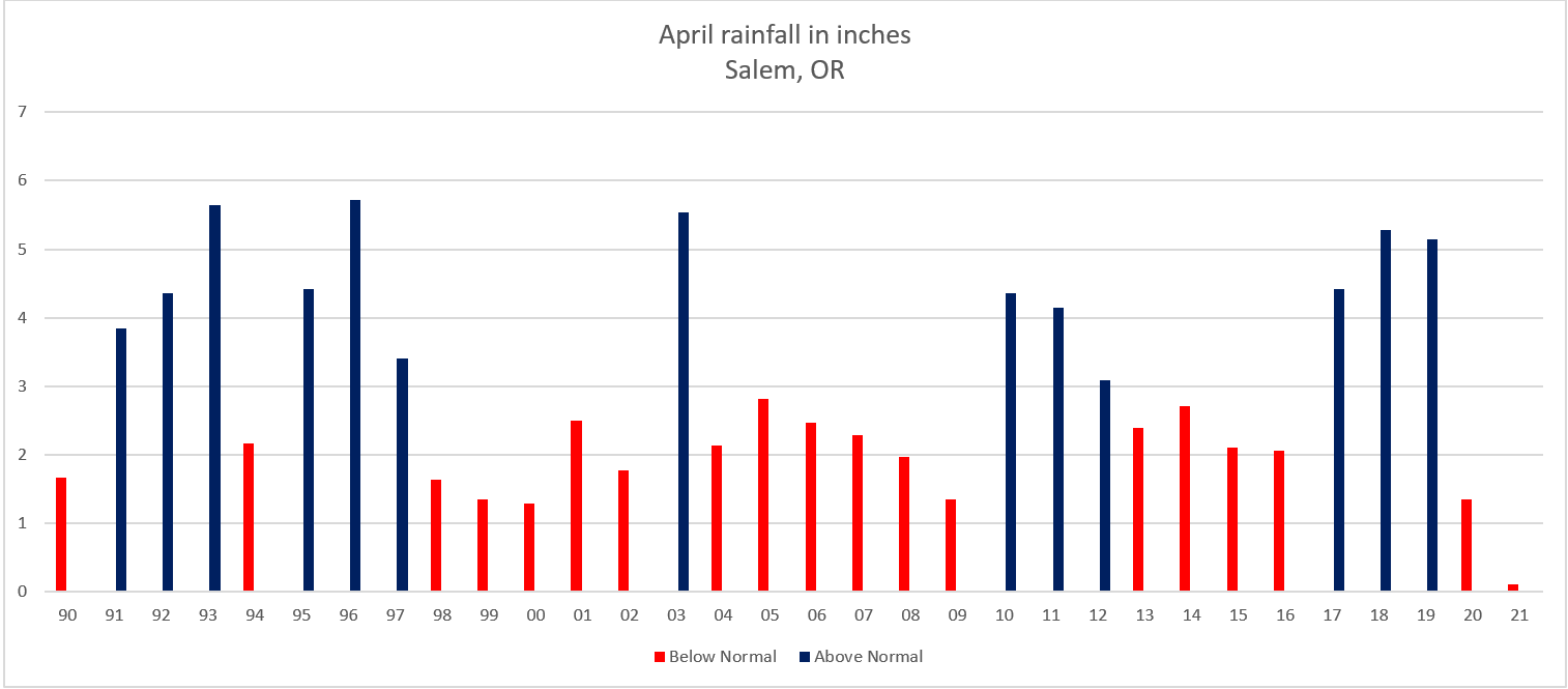
The other interesting thing this month has been the unusually dry weather. Very odd for April to be this dry. Do you realize that we’ve seen a mere 9% of our typical rainfall for this point in the month?!? It’s going to be a long summer if we don’t get a few good soakings later this spring. This graph shows the total rainfall for each April since 1990. Red years were below average while blue ended up with wetter than normal rain totals.
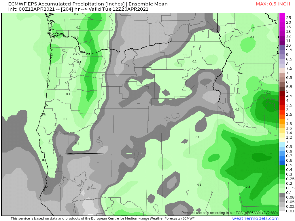
This next map shows estimated total rainfall in inches through next Monday. Basically nothing more than maybe a tenth of an inch falling on next Monday which means our extremely dry April is going to continue.
Might as well make the most of the dry weather though. For all we know May could be gloomy and wet. This whole week and coming weekend will be dry – no question about it with the next chance of rain being (as stated above) next Monday at the soonest. The warmest days will be Thursday – Sunday with highs in the 70s and maybe even low 80s Saturday and Sunday!!
There you have it. Enjoy the sunny and warm weather!
Winter is done and it’s time to see how my outlook faired when compared to reality. This is the full meal deal with lots of info, so make sure you’re sitting comfortably for this one lol 🙂 . If you’re looking for a forecast just know that we have a few showers coming in tonight through Thursday morning and then one more cool and showery day on Saturday before we dry out and warm up setting the stage for a very mild and sunny stretch of weather next week.
WINTER 2020/2021 REVIEW
Back in October it appeared as though we had a moderate La Nina on tap and I laid out several things that were more likely to occur during a La Nina winter based off of similar winters in the past. In case you wish to travel back in time to see what my thoughts and predictions were you can check out my 2020/2021 winter outlook here: https://bryanweatheralert.com/2020/09/28/winter-2020-2021-outlook/
1.) Wetter than normal: (OKAY). Nov and Dec were both slightly below normal, Jan was fairly wet, Feb came in a little above normal, but March finished out well below average. When all was said and done, Salem ended up right around average in the precip category. I stated in my winter outlook that a dry winter was very unlikely, and that part held true. This winter was definitely not a dry one, but to call it a wetter than normal winter would be a little bit of a stretch.
2.) Above normal mountain snow: (GOOD). We started the season off strong with above normal snowfall in November, but a warm and slightly drier than normal December brought the snowpack below normal by the time we rolled into January. Fortunately a few well timed storms in December kept enough snow on the ground through Christmas break to keep most of the ski areas operational – something we did not have the previous December.
The snowpack didn’t really increase much though until the end of January when we saw our brief snow event, and again with the colder weather during mid February. The cooler and wetter weather in February brought tons of snowfall to the mountains and pushed us above normal again. Occasional cool systems through the month of March maintained a very healthy snowpack as we headed into spring. With all things considered I call this forecast a hit with the snowpack being at or above normal for the majority of the winter.
3.) Flooding: This was not as much a forecast as it was more of a warning or heads up. I’m more than happy to have not had a big flood this year – something I think everyone could agree on… Flooding events are significantly more common during La Nina winters and that’s just a fact. We had no flooding on the Willamette River this year; however, we did have some localized flooding on several of our smaller rivers and streams in the region with a wet system in mid December, and then on a larger scale again in the first half of January when the valley saw 2 inches of rain in 24 hours with a storm on the 12th. Odds favor we see another La Nina next winter which means I would again sound the alarm for the potential for major flooding as this seems to be a trademark of La Nina winters around here.
4.) Snowfall. (GOOD). If you recall, I mentioned how the odds of seeing at least a little bit of snow increases with La Nina winters. Sure enough we saw some with our surprise snow event on January 26th which dumped a quick 1 to 4 inches of snow (depending on location) across Salem, and of course we also had our historic ice storm in February. So while the snow was short lived right here in Salem, we still picked up both snow and ice this year reinforcing the statement that La Nina winters tend to deliver at least some snow or ice. The official snowfall total I’m going with is 2.5″ and 1.25″ of freezing rain.
As far as wind goes, right here in Salem we had no major windstorms (widespread 50mph+ gusts). That said, the region did experience several minor to moderate wind events which brought scattered power outages to the Willamette Valley each time with the January 12th storm being the strongest windstorm
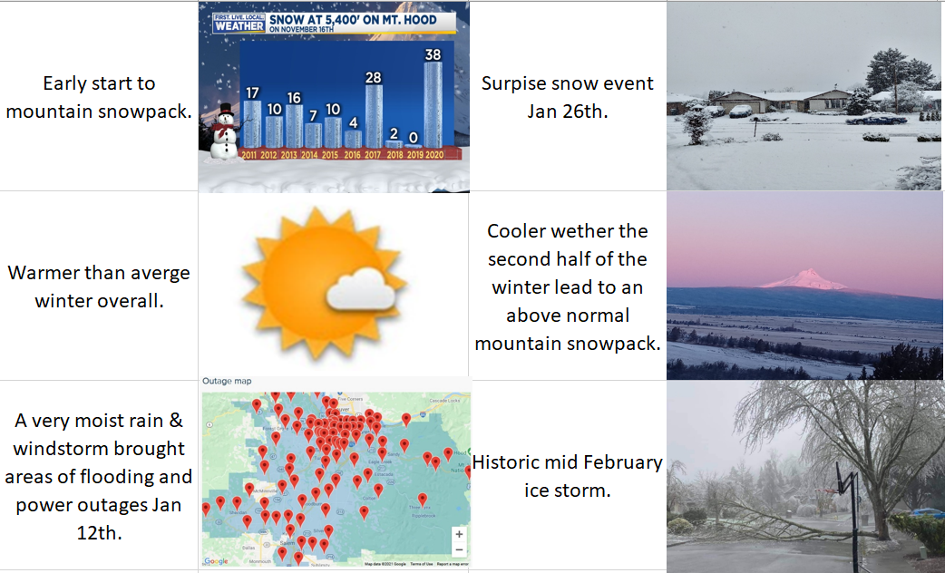
Next I have a graphic with the biggest highlights from this past winter.
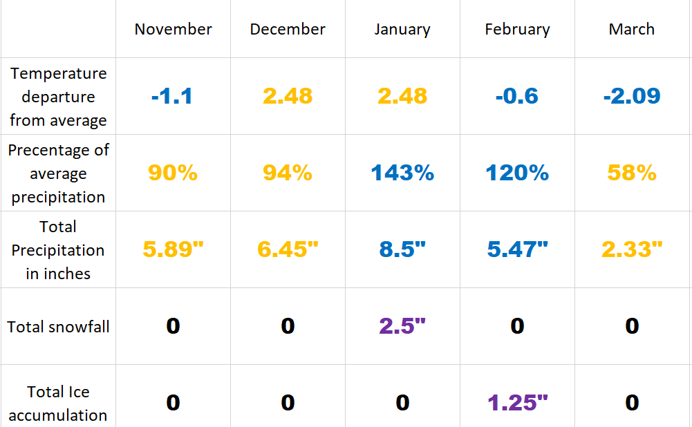
This second graphic shows how each month stacked up compared to average in both temperature and precipitation. I also included total rainfall per month, snowfall, and ice accumulation. Kind of a nice and neat way of seeing how each month faired.
Having both December and January on the much warmer side of things is unusual for a La Nina. As far as the precip went, the wet January and February balanced out pretty well the three drier months leaving us right at average for the whole period. Looking ahead, early indications are La Nina will return in the fall. This is represented on the chart below which shows how most first year La Nina winters are usually followed by a second La Nina winter.
If next winter is indeed a La Nina, I would put my money on a more active year with a decent chance of a wetter than normal winter. I would also expect at least some valley snow again, a higher than usual chance for major flooding, an increased risk of a significant windstorm, and a healthy mountain snowpack. But let’s not get too excited or ahead of ourselves lol. I enjoy every season and the weather each one has to offer. I’m looking forward to some beautiful sunny spring weather – maybe a few thunderstorms mixed in (if we are lucky), and then hopefully a nice and warm, but wildfire free summer. 🙂