Summer 2019 update, a look ahead, and special announcement

This summer has no doubt been cooler than a number of our more recent summers, but all & all still plenty of warm & sunny days, and there’s a benefit to our cooler and slightly wetter summer, and that’s the lack of wildfires.

I’ve noticed, and I imagine many of you have noticed the lack of thick smoke in the air both at the surface and far overhead like we have seen on so many occasions over the past few summers.  Definitely a lot more blue skies and a lot less haze this year.  Also, to the very best of my knowledge there are no major wildfires burning in the Cascades or Central Oregon for that matter which is a huge change from recent summers.

So a “cooler” summer really isn’t too bad with all things considered.

Extended Forecast

8.19


Details

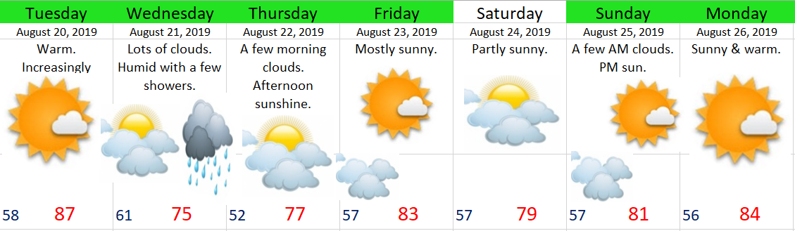
Tuesday:  Sunny with increasing clouds & humidity later in the day.

Wednesday:  Lots of clouds around, muggy with a few showers.  Some showers could be rather vigorous.  Maybe even a clap or two of thunder.

Thursday:  A fairly cool start to the day with lows dipping close to 50°.

Friday:  Warm & sunny.

Saturday:  Slightly lower confidence Saturday (as noted by the lack of green highlighting).  For now I’m leaning towards a partly sunny day with highs around 80°.  There’s a weak little “storm” (or more accurately a batch of clouds) I’m watching which could ruin that forecast and keep temps down closer to the low 70s.

Sunday & Monday:  Warm with sunny skies!

Beyond next Monday:  Looks warm & dry as we head towards the end of August.


Special announcement…

I’m sure you all are waiting at the edge of your seat for this 😉

Are you ready?!?!?   I’m pleased to announce that Bryan Weather Alerts is expanding to the world of Instagram and Facebook!!!!!!!

LOL….  Okay, so it’s maybe not that exciting to you, but I’m thrilled!!  The Facebook Page in particular will be a great place for all of you, my incredible followers, to post awesome weather related photos for the purpose of sharing with others, for using right here on the website in updates, and on occasion, use on the Instagram Page.  This will be especially fun and useful during storms and snow events.  🙂   You can find the page right here:  https://www.facebook.com/Bryan-Weather-Alerts-105605014141422/


A very wet April

There has been a lot going on lately with the weather and I figured it was past time to get all caught up.  We are looking at one of the wettest Aprils on record, snow in the mountains, and intense flooding across the area.  Flooding in the Willamette Valley has been the worse since January 2012, and in some places all the way back to November 1996!  Right now Salem is 3 inches above normal for rainfall at this point in the month.

This picture was taken on Wednesday.  It shows highway 34 crossing the Willamette River on the eastern edge of Corvallis.  Very high water levels will continue for another day or two.

river flooding 4.10.19

This is a chart of the Willamette’s river level in Corvallis.  It crested at 32.8 feet.  For reference the February ’96 flood crested at 33.5 feet down there.  Pretty incredible!

Corvallis river level


Extended Forecast

I’ve got an updated extended forecast here for you as I’m sure you’ve all been struggling through life without one over the past several days 😉

April 11

Details

Fairly high confidence with the exception of Tuesday and Wednesday.  Both those days could be wetter or drier than currently forecast.  Right now I’m sorta splitting the difference and banking on Wednesday being a drier day while Tuesday stays on the showery side of things. 

High confidence that we enter into a dry spell stating next Wednesday/Thursday, and there are indications that this dry spell will last through Easter weekend 🙂

In the meantime we have several more cool and showery days ahead.  I’ll leave you with this snowfall map showing a solid 10 to 20 inches of new snow for the Cascades by the end of Tuesday with the highest amounts above 5000′.  Winter is trying hard to hang on. 

mountain snow mid April


Snowy central Oregon and cold start to March

Happy Friday!!  I’ve revised the forecast for today as we should be dry the rest of the day, but staying chilly.  This will kick off a multi-day stretch of dry weather with the next chance for precipitation not showing up until Wednesday.


Next I wanted to share a few images with you all to help convey just how much snow is on the ground east of the Cascades. 

First up is a satellite pic from yesterday before the clouds moved in all the way.  Some of the white you see are clouds especially along the edges, but for the most part it’s all snow cover from the Cascades eastward.  Have I told you how much I love the clarity of this new satellite?  Notice how you can easily see both the Columbia and Snake Rivers as they flow through the frozen landscape.  Pretty neat ehh?!?

snow cover 2.28

Next I have several images saved from various traffic cams over the past few days.  Most of these come from Central Oregon where 25 to 35+ inches of snow have fallen this week alone!


Lastly I have a few pics from Bend, OR taken Thursday morning where they have received over 30 inches of snow over the past several days.  Absolutely incredible!!!  Photos taken by Darius Marvasti.


Speaking of snow, check out these images showing how the snowpack in Oregon has progressed from early December to now.  A major turnaround from where we started!


Looking ahead I see several dry days headed our way.  This dry weather will be accompanied by some very cold temperatures.  It will be the battle of the seasons with the early March sun versus the very cold air mass.  As a result I expect morning lows to dip all the way down into the low to mid 20s Saturday through Wednesday.  For the afternoons I’m banking on the early March sun getting us up close to 50° despite the very cold mornings.  You may not think upper 40s/close to 50 is all that warm, and it isn’t, but keep in mind that if we had this very same air mass in January we would be talking about highs in the mid to upper 30s instead.  Just a little perspective for you 😉


PS.  No lengthy snowstorm recap, but I was happy with how everything turned out Tuesday night/Wednesday morning.  It appears as though everyone recieved about 1 to 2 inches of snow here in the Salem area.  Felt nice to have a snow forecast pretty much work out 🙂

Feb 25th storm recap & forecast

Time for another addition of “The Good, the Bad, & the Ugly!”

The Good, the bad & the Ugly!

I’m sitting here tonight happy that everyone got at least a little bit of snow (good).  My forecast of 3 to 5 inches was too high (bad).  Totals ended much closer to 1 to 3 inches.  The higher hills in south Salem received 3 inches (good).  Everyone else ended up closer to the 1 inch range (bad).

The Eugene and Springfield area received some very heavy snowfall with 8 to 14 inches for most locations south of roughly Junction City and Brownsville (good).

The temperature last night in Salem was a couple degrees warmer than I anticipated which resulted in a longer and slower than expected transition from rain/snow mix to all snow last night (bad).

It’s been a cold day.  The sun never came out and we stayed in the 30s all day long (good).  In fact our high temp today was 38° recorded just after midnight before the rain, snow, and colder air moved in.  Our “daytime high” temp was only 36°.

It wasn’t a huge storm or even close to it for the immediate Salem area, but as you can see we were not far from receiving much higher totals had the snow band stalled just a little closer to us.  See how a little distance can make a huge difference??


All things considered I feel good about how the forecast turned out.  A little bummed it ended up being another mediocre snow event here in Salem as we yet again managed to avoid the heavier snow, but I’ll take 1 – 3 inches over nothing almost any day. 🙂  😉

Here’s some pics from around the region to help give an idea of the different conditions experienced.  This first set is from the hills of south Salem.

This pic comes from the hills of Eugene courtesy of Micah Sardell where 16 inches fell!!

Eugene 2.25 Micah Sardell

And last, but not least, from my own backyard 😉


A look ahead, and sorry, but no super fancy graphic tonight 😉

Tonight:  Cold & dry.  A very chilly night with lows getting into the mid to low 20s.  Icy roads likely in spots.

Tuesday:  Very cold start, but should stay dry.  Highs in the upper 30s.

Wednesday:  Light snow during the morning hours transitioning to flurries or even some sprinkles during the afternoon.  For now I’m leaning towards just a dusting to an inch tops.  I expect no real travel issues Wednesday unless this storm ends up being stronger than current forecasts are predicting.

Thursday & Friday:  The threat for snow & rain showers continues with highs in the upper 30s to low 40s and lows generally between 29 and 32°.

Saturday – Monday:  Lots of sunshine, very cold mornings, and dry.  Lows 22 – 26°, and highs 44 – 50°.

Will be watching late Tuesday night through Friday for any changes, but as of right now I’m not seeing any major snow events during this time frame.


The Cascades and Beyond

Up in the mountains, and basically everywhere east of the Cascades it’s been ridiculously snowy, and with more snow on the way I don’t expect easy travel condions in those parts anytime soon.