Snowy central Oregon and cold start to March

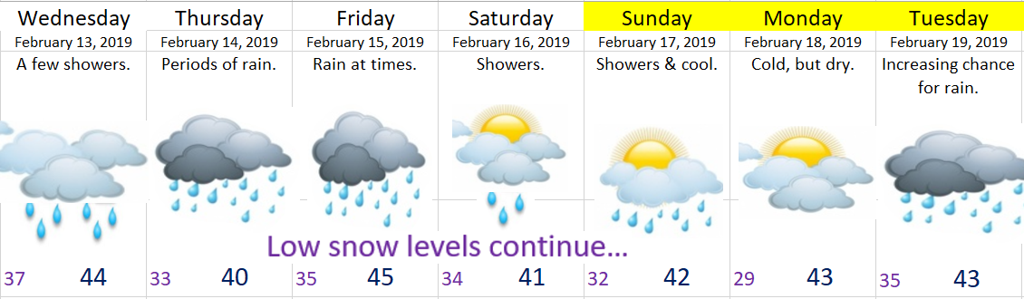
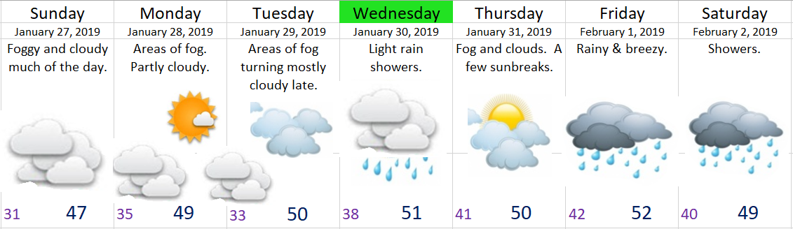
Happy Friday!!  I’ve revised the forecast for today as we should be dry the rest of the day, but staying chilly.  This will kick off a multi-day stretch of dry weather with the next chance for precipitation not showing up until Wednesday.


Next I wanted to share a few images with you all to help convey just how much snow is on the ground east of the Cascades. 

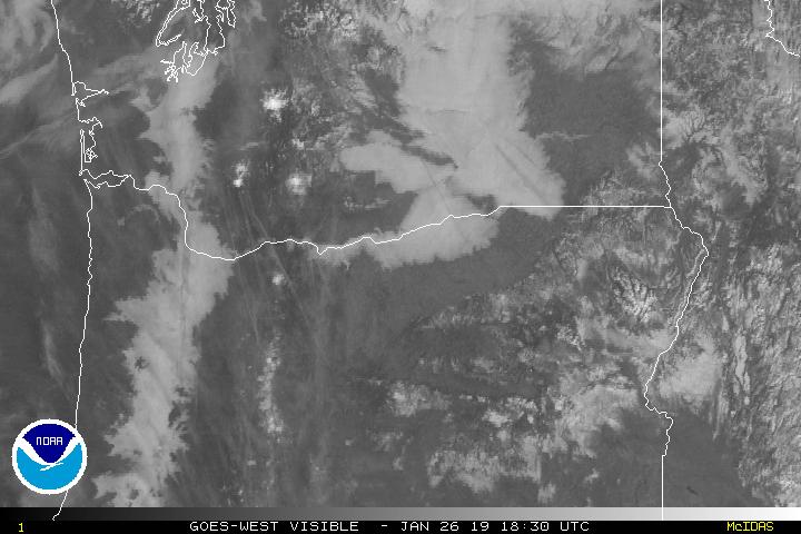
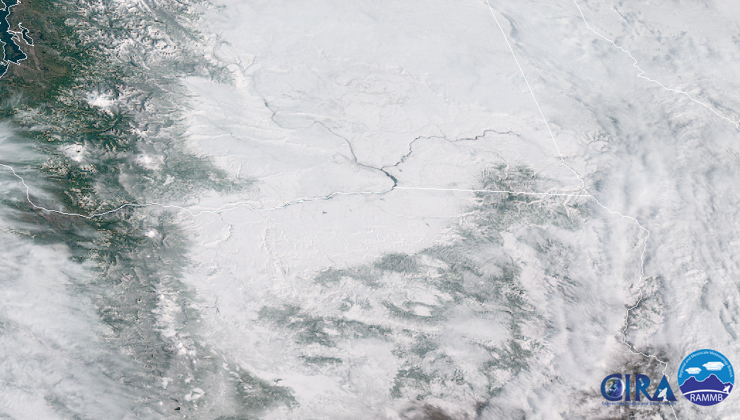
First up is a satellite pic from yesterday before the clouds moved in all the way.  Some of the white you see are clouds especially along the edges, but for the most part it’s all snow cover from the Cascades eastward.  Have I told you how much I love the clarity of this new satellite?  Notice how you can easily see both the Columbia and Snake Rivers as they flow through the frozen landscape.  Pretty neat ehh?!?

snow cover 2.28

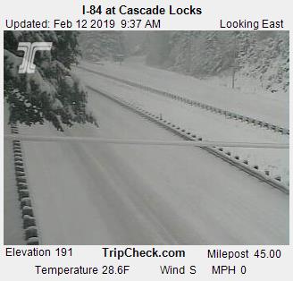
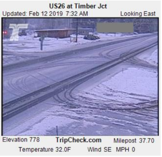
Next I have several images saved from various traffic cams over the past few days.  Most of these come from Central Oregon where 25 to 35+ inches of snow have fallen this week alone!


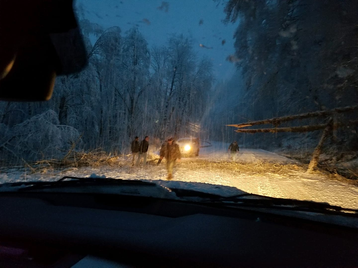
Lastly I have a few pics from Bend, OR taken Thursday morning where they have received over 30 inches of snow over the past several days.  Absolutely incredible!!!  Photos taken by Darius Marvasti.


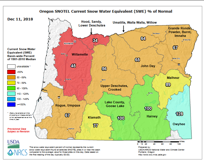
Speaking of snow, check out these images showing how the snowpack in Oregon has progressed from early December to now.  A major turnaround from where we started!


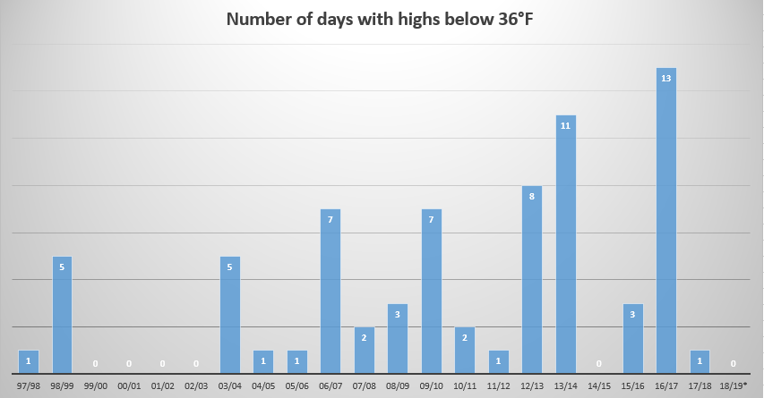
Looking ahead I see several dry days headed our way.  This dry weather will be accompanied by some very cold temperatures.  It will be the battle of the seasons with the early March sun versus the very cold air mass.  As a result I expect morning lows to dip all the way down into the low to mid 20s Saturday through Wednesday.  For the afternoons I’m banking on the early March sun getting us up close to 50° despite the very cold mornings.  You may not think upper 40s/close to 50 is all that warm, and it isn’t, but keep in mind that if we had this very same air mass in January we would be talking about highs in the mid to upper 30s instead.  Just a little perspective for you 😉


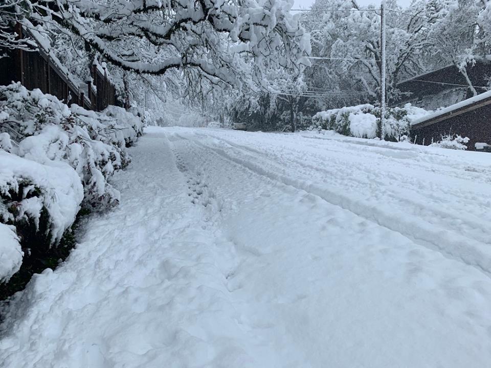
PS.  No lengthy snowstorm recap, but I was happy with how everything turned out Tuesday night/Wednesday morning.  It appears as though everyone recieved about 1 to 2 inches of snow here in the Salem area.  Felt nice to have a snow forecast pretty much work out 🙂

Feb 25th storm recap & forecast

Time for another addition of “The Good, the Bad, & the Ugly!”

The Good, the bad & the Ugly!

I’m sitting here tonight happy that everyone got at least a little bit of snow (good).  My forecast of 3 to 5 inches was too high (bad).  Totals ended much closer to 1 to 3 inches.  The higher hills in south Salem received 3 inches (good).  Everyone else ended up closer to the 1 inch range (bad).

The Eugene and Springfield area received some very heavy snowfall with 8 to 14 inches for most locations south of roughly Junction City and Brownsville (good).

The temperature last night in Salem was a couple degrees warmer than I anticipated which resulted in a longer and slower than expected transition from rain/snow mix to all snow last night (bad).

It’s been a cold day.  The sun never came out and we stayed in the 30s all day long (good).  In fact our high temp today was 38° recorded just after midnight before the rain, snow, and colder air moved in.  Our “daytime high” temp was only 36°.

It wasn’t a huge storm or even close to it for the immediate Salem area, but as you can see we were not far from receiving much higher totals had the snow band stalled just a little closer to us.  See how a little distance can make a huge difference??


All things considered I feel good about how the forecast turned out.  A little bummed it ended up being another mediocre snow event here in Salem as we yet again managed to avoid the heavier snow, but I’ll take 1 – 3 inches over nothing almost any day. 🙂  😉

Here’s some pics from around the region to help give an idea of the different conditions experienced.  This first set is from the hills of south Salem.

This pic comes from the hills of Eugene courtesy of Micah Sardell where 16 inches fell!!

Eugene 2.25 Micah Sardell

And last, but not least, from my own backyard 😉


A look ahead, and sorry, but no super fancy graphic tonight 😉

Tonight:  Cold & dry.  A very chilly night with lows getting into the mid to low 20s.  Icy roads likely in spots.

Tuesday:  Very cold start, but should stay dry.  Highs in the upper 30s.

Wednesday:  Light snow during the morning hours transitioning to flurries or even some sprinkles during the afternoon.  For now I’m leaning towards just a dusting to an inch tops.  I expect no real travel issues Wednesday unless this storm ends up being stronger than current forecasts are predicting.

Thursday & Friday:  The threat for snow & rain showers continues with highs in the upper 30s to low 40s and lows generally between 29 and 32°.

Saturday – Monday:  Lots of sunshine, very cold mornings, and dry.  Lows 22 – 26°, and highs 44 – 50°.

Will be watching late Tuesday night through Friday for any changes, but as of right now I’m not seeing any major snow events during this time frame.


The Cascades and Beyond

Up in the mountains, and basically everywhere east of the Cascades it’s been ridiculously snowy, and with more snow on the way I don’t expect easy travel condions in those parts anytime soon.

A look ahead & storm recap

Forecast

Looking ahead I don’t see a good setup for snow still.  I don’t see a big warmup either as we continue to stay in this cold and wet pattern for the foreseeable future.  That part of the forecast has worked out very well as February is currently running far below average for temperature.

Feb 12


Storm recap

The past 36 hours have been wild and interesting to watch unfold at least from a weatherman’s perspective.  We had gusty south winds all Monday night and through Tuesday morning.  I’m sure you noticed them.  Gusts to 40mph were reported four separate times at the Salem airport.  Meanwhile areas to our northwest have been pounded by heavy rain causing flooding on many creeks and streams specifically up in Washington, Clatsop, and Tillamook counties.  Here’s what the radar looked like Tuesday morning.  Two things stand out.  First is the heavy rain just to our north, and the second is the heavy snow (in blue) just west of the Portland Metro area.

radar 2.12

I work very hard writing my own forecasts and making my own graphics, but I just don’t have a fancy studio or programs to create nice graphics which means today I’m borrowing from a local professional.  This image is brought to by Mark Nelson over on Fox 12 Oregon.  These precip totals were only through 10am, so I imagine much more fell as the day went on!!  You can clearly see locations to our north and west received far more rain this morning which led to the flooding issues up there.  I’ll try to have some official rain totals later.

Fox 12 precip 10am 2.12

Then there was the gorge where cold air kept snow falling along I-84 all day long.  Here’s I-84 at Cascade Locks from Tuesday morning.

CascadeLocks 2.12

No snow today as you might have noticed here in the Salem area, and that’s primarily a result of just not enough cold air and the rain band stalling a little too far north of us as the previous images revealed.  If the precip band had been directly over us it could have been a different story.  The locations where it did stall saw heavy wet snow fell below 1000′ causing trees to fall and messes like this scene from highway 6 early Tuesday morning in the northern Coast Range.

highway 6 2.12

Some additional proof that snow fell to low elevations Tuesday morning.  Here’s US 26 west of the Portland metro a little ways.  You can see snow had no trouble here sticking down to 778′ and even a bit lower in surrounding areas.  All in all a crazy day!

US 26 snow 2.12

I am sorry about the lack of a good snowfall here, but I’m thinking there’s nothing I can do about it.  Trust me I’m just as sad, and I keep telling myself this must be setting us up for an incredibly huge amount of snow sooner than later.  I mean that’s got to be how it works, right???  After all, Portland has received several inches so far this winter, Seattle is looking at historic snowfall for February, and even as I write this, it’s snowing and 32° in Redding California right now!!!  Sooner or later Salem has got to receive its “fair share” of snow.


Fog for the win

All week long I’ve mentioned my concerns about fog developing this weekend keeping our temps cooler than they would otherwise be.  Turns out the fog won.  You can see the entire valley cloaked under the blanket of fog on this visible satellite image from this morning.

fog 1.26

If we had stayed free of the fog (say that 3 times fast) we could easily be in the 50s right now.  Just look at the temp at the top of Santiam Pass right now.  It’s a balmy 54° with more daytime to come.  It will get up to almost 60 up there today!!  Back here in Salem it’s a nice cool 39° thanks to our fog 😉

santiam pass warm 1.26

I see no reason why Sunday and possibly Monday won’t also end up foggy.  In fact there’s a chance for fog almost every single day this next week.  The only exceptions are the days it’s supposed to rain lol…  Here’s a look at the next 7 days.  Notice the lack of green highlighting indicating the variability in our temps which all depend on how much or how little fog we end up with.

jan 26

  • Dry through Tuesday
  • Showers on Wednesday
  • Dry Thursday
  • Wet for next weekend

Last, but not least I have some food for thought.  This graph shows the number of days with highs below 36°F per winter for Salem, OR.  It goes back to the winter of 1997/1998.  In the scheme of things this is a very short time frame, so don’t draw too many conclusions from it.  I just thought it was a fun bit of info to share.

salem cold high temps


Low snowpack

OR snowpack 12.11

This map depicts the percentage of water stored within the snowpack relative to normal.  You can see most of the state is well below normal.  A combination of mediocre storms and lots of dry days (think back to just last week) and we end up with this low, below average snowpack.

Notice how the southern regions are reporting close to and even above normal conditions.  Above average precip in southern Oregon is common during El Nino winters (like the winter we are in now), and I expect that trend to continue.

To give you an idea of how low the snowpack is, the current base at Hoodoo ski area is 18.5″ of snow.  Not very good.


Forecast

In the meantime I see 5 to 12 inches of snow coming for the mountains tonight and tomorrow.  More the higher up you go in elevation, but even a few inches as low as 2500′ are possible.

Beyond tomorrow I don’t see very much snowfall in the forecast unfortunately.  Hopefully later in the month we can get a series of colder and wetter storms to really build the snow up a bit more.

Historic Dry Streak

As of September 4th we have gone 85 days straight with no measurable rain at the Salem Airport.  In the weather world “measurable rain” is one hundredth of an inch (.01″) or more which means “trace” amounts do not count.


Putting our drought & historic dry streak in perspective

1.)   Long periods without rain here in Salem is nothing new.  85 plus days in a row is no doubt a heafty streatch of days, but 3 of our top 5 longest dry streaks in recorded history took place before the Great Depression, and all 4 runner ups took place over 50 years ago.

dry graphic

2.)   Keep in mind that summer in Oregon is always dry with the exception of a rare thunderstorm or light shower.  This year we just so happened to not get any of those at all.

3.)   Winter is when we typically receive most of our precipitation and snowpack up in the mountains which is why having a dry winter is much more worrisome than having a dry summer.  Our wet fall/winter seasons usually have little trouble erasing summer drought every year with the exception of eastern Oregon which relies heavily on rain from springtime thunderstorms in addition to winter rain & snow.

4.)   For comparison I put together this graphic showing statewide drought conditions centered on the end of August from recent years, and it shows quite well that drier than normal conditions in summer is nothing new.  Most of these years the drought in the western half of the state was completely gone by the following spring.  It’s amazing what our rainy winters can do!!

fun drought map chart

5.)    One final thing to help us gauge where we are at with this drought.  Take a look at the water level of Detroit Lake.  This chart goes back to September 2015.  You can see we are in the ballpark of where we ought to be this time of year and a lot better than where we were at in September 2015 which was a very bad drought year.  So all in all no major concerns here for now.

Detroit Lake stats

6.)   Lastly, I understand that many of us get tired of our winter rains, but we all know it’s the rain that keeps this state going.  With that in mind, let’s hope we have a nice rainy winter so this drought can become a thing of the past and nothing worse.