Wed – Fri: Cooler with lots of clouds and chances for sprinkles/light showers.
Sat – Mon: Warmer again with mostly sunny skies.
Wet weather recap
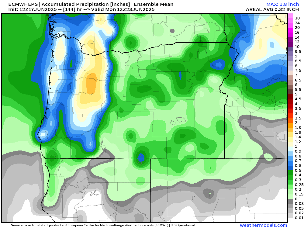
The rainy weather did not disappoint. In fact, Friday and Saturday were the rainiest back to back days since the first week of April! The map below shows rainfall totals from the weekend.
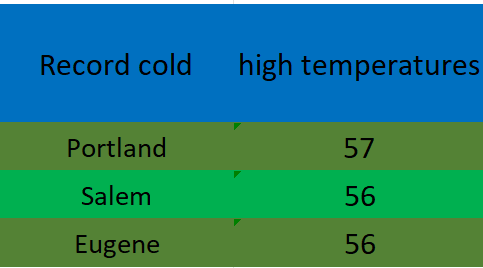
A solid half inch to inch in the valley and over an inch to two inches up in the foothills and mountains. The low pressure and steady rain was accompanied by chilly temperatures too. Record low high temperatures were set on Saturday all over the valley.
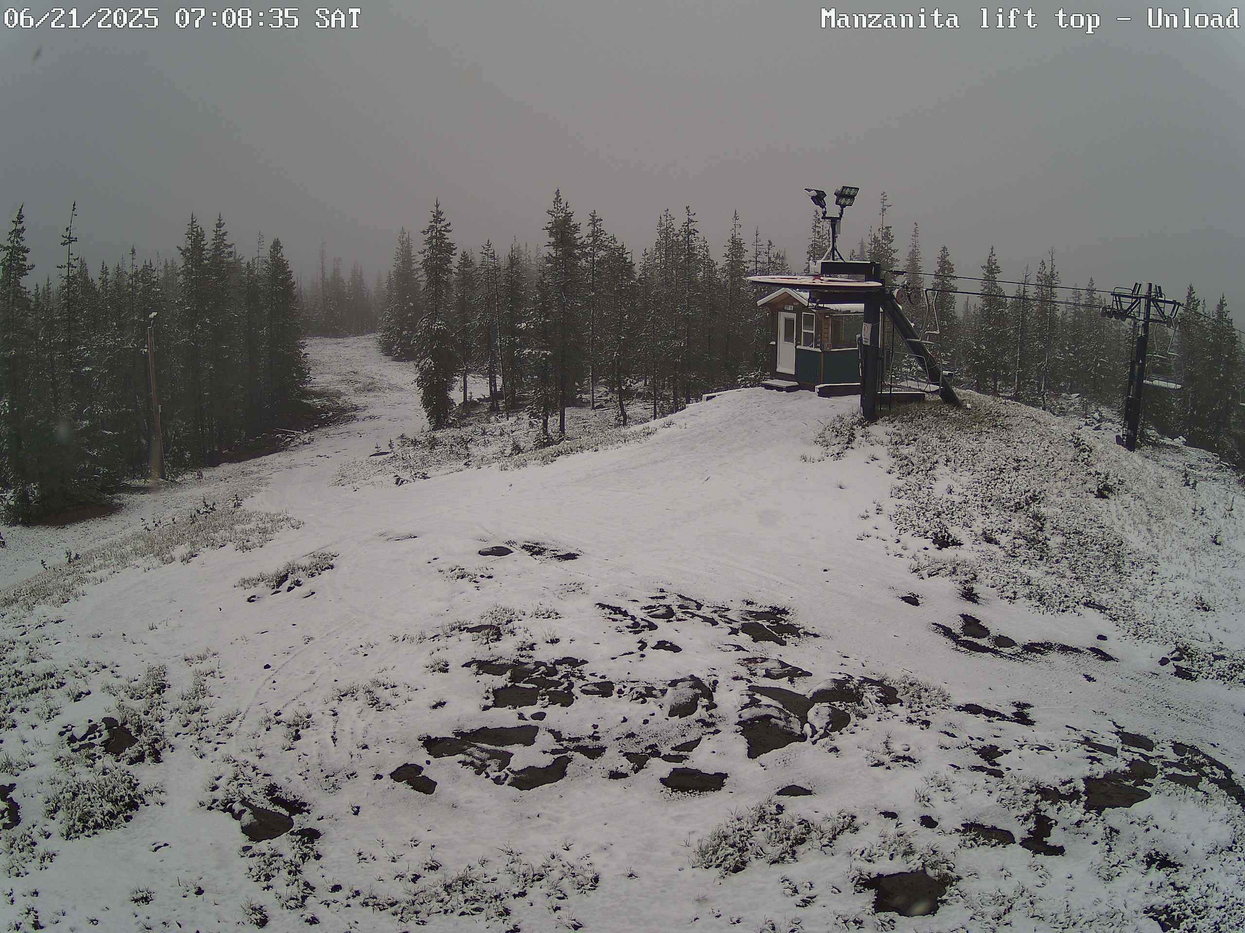
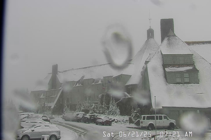
Snowfall also made it’s way to the Oregon Cascades. These two images show snowfall on Hoodoo and up at Timberline Saturday morning. Fun to see snow falling up there on the first full day of summer!
Forecast details
Tue: Very similar to the weather we saw today. Highs in the low 80s.
Wed – Fri: Each day will feature a very slight chance of drizzle or a few light sprinkles. Nothing widespread or heavy. Lots of cloud cover with sun breaks mixed in at times. Highs in the low 70s and early morning lows 53 – 55°. Best chance for any light showers or sprinkles looks to be Wednesday and Thursday with a lower chance on Friday.
Sat: Sunshine returns with highs in the lower 80s and mostly sunny skies. A real nice day after a refreshing start that morning with lows in the low 50s.
Sun & Mon: Sunny and warm with highs in the mid to upper 80s.
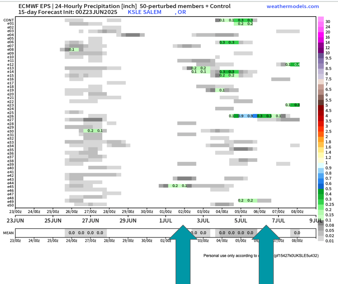
Looking further out to the first week of July it still appears we could have another shot at a few showers. Too far out to say with certainty, but there are enough individual members (horizontal lines) calling for rain at some point during the first week of July that it has my attention.
The biggest take away I see is that there is no sign of hot weather the next two weeks. Some upper 80s, but nothing prolong or real significant. I’ll keep an eye on that 4th of July forecast, but in the meantime enjoy the nice weather.
It’s been a long time since I posted. The weather has generally been extremely uneventful, plus I’ve been busier than usual with work and side projects (including the garden). Regardless, I figured it was time for an update.
The forecast
Wed & Thu: Onshore flow increases pushing in a stronger marine layer along with a very weak front. This will result in highs in the low to mid 70s. Expect plentiful AM clouds with PM sun breaks. We could see a sprinkle Wednesday morning; otherwise, these two days will remain dry.
Fri: PM showers. A cold atmosphere up above will result in the possibility of thundershowers too. Some of the downpours could be quite heavy. Highs right around 60°.
Sat: Additional showers and thundershowers with a more steady rain likely during the late afternoon and evening hours. This will produce a widespread soaking rain for areas west of the Cascades. Downpours will have potential to be heavy. Highs will struggle to reach 60°
Sun: Showers wrap up with much of the day being dry. Just keep in mind that showers could still take place during the day on Sunday. Highs into the lower 70s again.
Mon – Wed: Partly cloudy to mostly sunny skies. Highs around 80° each day. Lows will start out chilly right around 50 to 53°.
Rain totals look to range from half an inch to just over an inch of rain here in the Willamette Valley. This will bring much needed precipitation to our region!
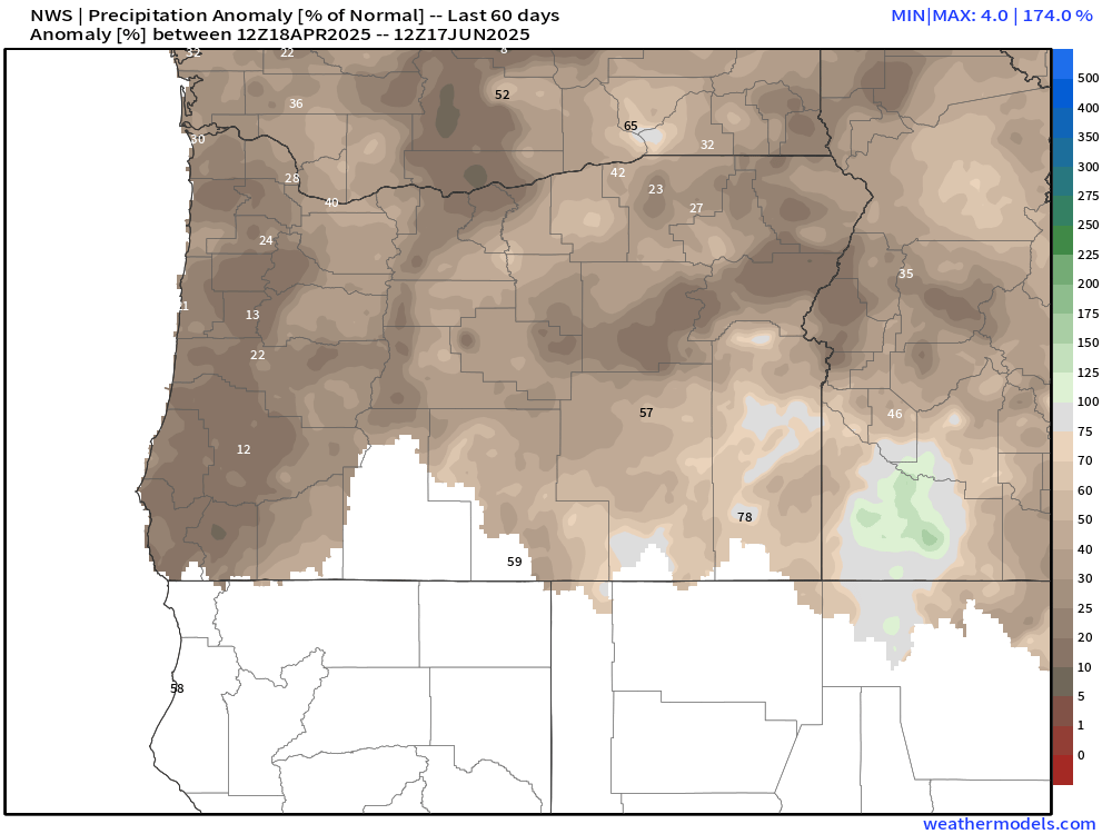
Aside from the first week of April, we have been unusually dry this spring. The few “rainy” days we have seen the past 8 weeks have not produced more than a third of an inch on any given day. The map below shows percent of normal precipitation locations have picked up between April 18th and June 17th. Many valley locations are running at a mere 15 to 25% of average.
We are running slightly better precipitation wise than the dry and hot spring of 2021. That year brought our most intense heatwave ever with temperatures soaring above 110° throughout the Willamette Valley. That was an awful experience. Luckily, no signs of hot weather.
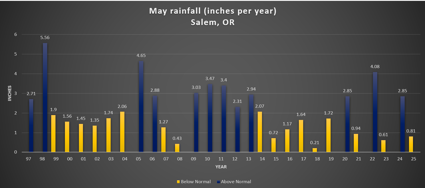
As far as temperature goes, May 2025 went down in the history books as only being 0.2° above normal. For all practical purposes that’s considered average. At the moment, June is running 3.5 degrees above normal, a special thanks to the hot spell last weekend. That number will fall dramatically by this time next week due to the much cooler weather moving in.
For reference, I added a chart showing total rainfall for Salem during the month of May going back to 1997.
There is no clear trend here. The only notable thing I could see was the tendency for totals to range more drastically over the past several years, but in the grand scheme of things, several years is hardly a trend.
We’ll see where we end up for rainfall in June. For now enjoy the continued dry weather, and keep in mind that Friday through Sunday will be generally wet.
The Cascades
Planning on hiking or camping up high? Well, plan on some snowfall Friday night through Saturday night. Snow levels will dip down low enough for the volcano summits/peaks to pick up several inches of snow. Timberline, the tops of the sisters, Jefferson Park, Crater Lake, and any other peaks above roughly 5500 feet could see snow this weekend. Keep this in mind. Spots along the PCT (Pacific Crest Trail) could also see snowfall impacting hikers and backpackers this weekend. By Sunday afternoon the summer sun returns and the snow up there will quickly begin melting off again.
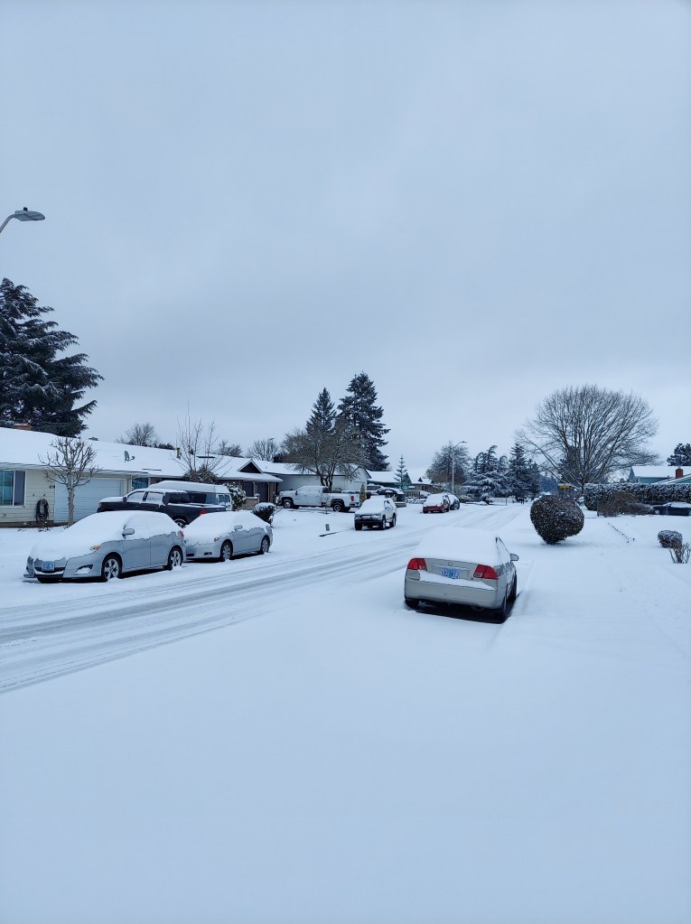
Woo hoo! Snow has been widespread across the entire mid Willamette Valley! It’s clear now that we have either hit the upper end of my forecasted snow totals or surpassed them for this point in our winter storm with more on the way tonight through Friday morning.
At the moment we are currently in between the rounds of heavier precip, and the “heating of the day” has helped major roads clear up a bit, but conditions go down hill tonight as temperatures drop and as round #2 moves in, so don’t get stuck out there thinking all is well.
What’s ahead?
More snow tonight with freezing rain and sleet mixing in. This second wave of moisture still looks quite “juicy” lol with a solid half inch of melted down precip (or more) with round #2. I currently expect at least a little bit of freezing rain or sleet to mix in tonight before changing back over to all snow; however, models have already been trying to push the cold air out of here too quickly, and so for the moment I’m leaning towards more snow and not as much in the way of ice.
Either way, winds continue to breeze out of the north, and temperatures will be plenty cold enough that whatever falls from the clouds will be frozen or will freeze on contact (freezing rain). My best guess is an additional 2 to 5 inches of snow with some freezing rain. If this storm continues to overperform I could see us surpassing those totals too! There are always little twists and turns with our winter storms here…
Snow will come to an end Friday morning, but with the colder than expected temperatures and increased snowfall, we should plan on road conditions improving very SLOWLY through the day on Friday with side roads remaining in rough shape.
Refreezing Friday night with clearing skies will lead to more issues again on side roads and less traveled streets through early Saturday morning before finally thawing out the rest of the way.
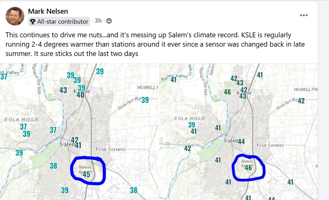
One additional thing I want to mention is how the Salem Airport temperature sensor has been regularly reporting a bit warmer than surrounding stations. Even warmer than weather observation spots in downtown and east along Lancaster Drive. Mark Nelson posted this graphic from the other day showing just how off it’s been and that he has tracked this for a couple years now. He does excellent work for Fox 12 and I appreciate his attention to details and to locations outside the PDX metro if you ever need a good forecaster to watch on TV.
So if you’re curious why your weather sensor at home has you in the upper 20s, but your weather app says otherwise, well now you know! Even right now you can see it is way off compared to the rest of the city and local area sitting at 34° while the rest of us are in the upper 20s to around 30°.
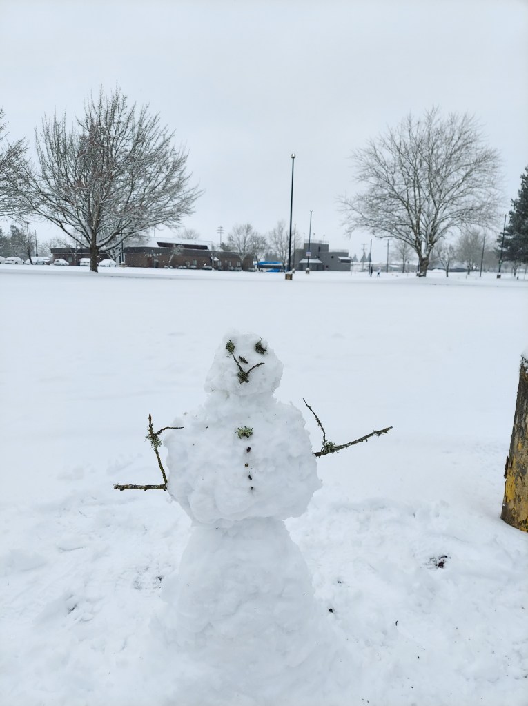
Stay safe, and keep on enjoying the snowy and wintry weather!! 🙂
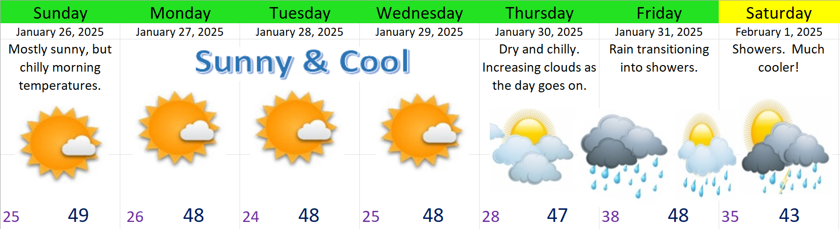
We have about 5 more days of dry weather before rain finally returns to our region Thursday night or Friday. Mostly sunny skies, cold nights, and highs in the upper 40s will continue through Wednesday. Thursday should be dry, but with increasing clouds, and actual rain returns late that night. Showers should continue through next weekend with lowering snow levels. Colder and possibly snowier weather is possible as we head into February. More on that at the end of this post. 🙂
Details
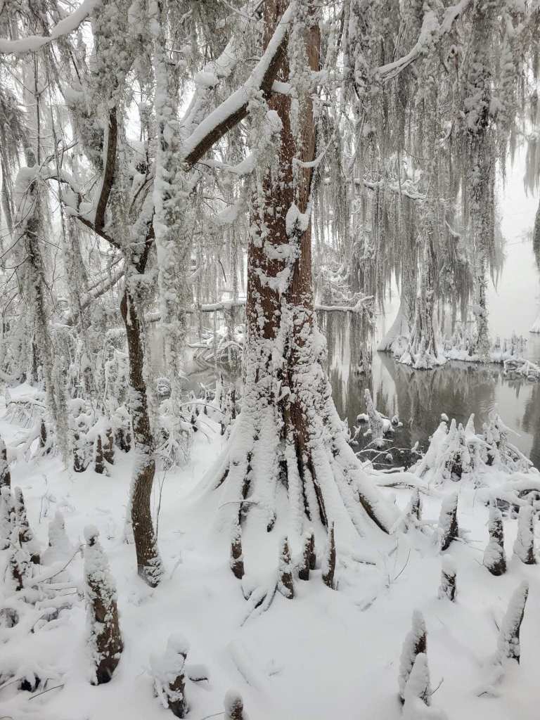
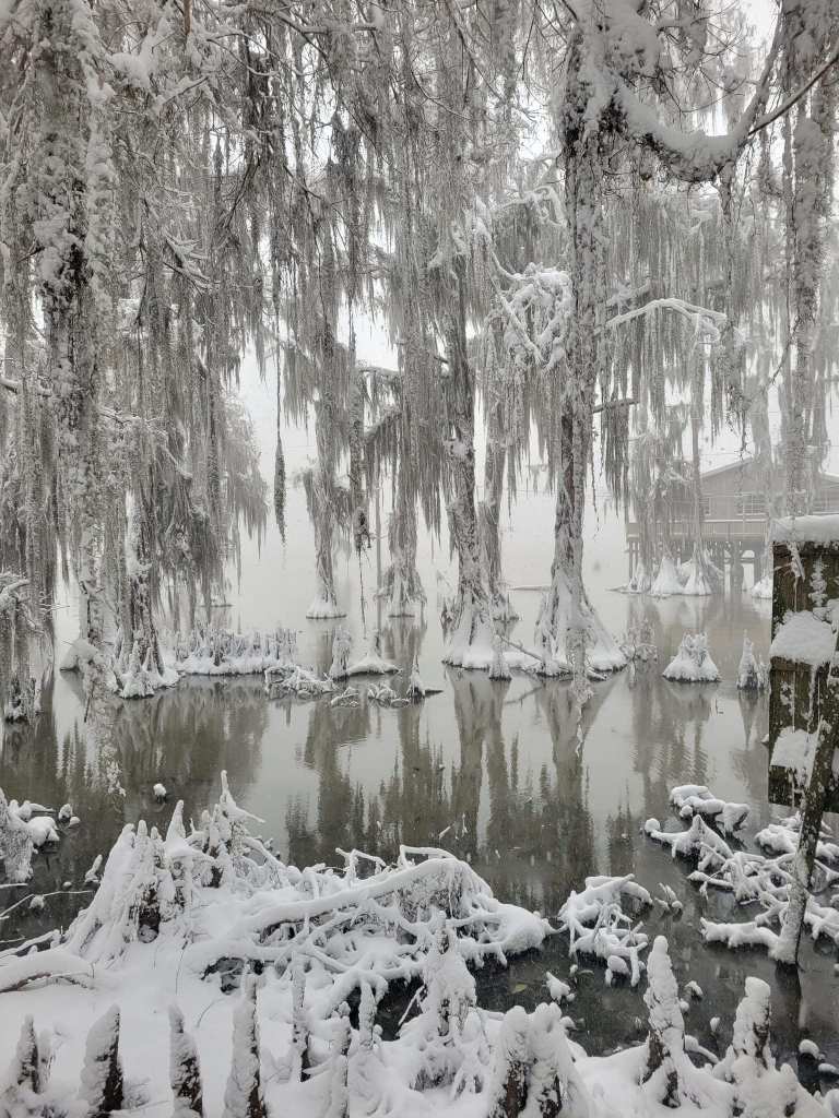
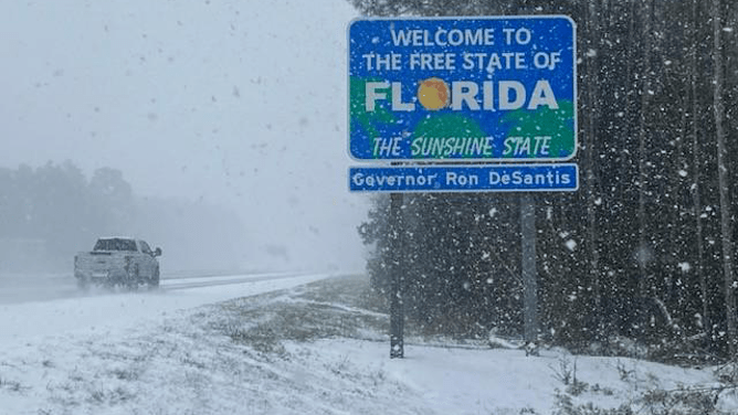
As you all know by now, the deep south had an extremely rare and historic snowstorm this past week. Actual blizzard conditions where observed in many locations from Louisiana to Florida. These photos of the snow covered and frozen bayou and blizzard like conditions along the freeway heading into Florida are just amazing and almost unbelievable.
Here in Salem we got gently brushed (again) by that large mass of frigid arctic air. That is why our air has been dry, our days have been sunny with no more fog, and our nighttime lows have dipped well into the 20s several degrees below average. This weekend we are again getting brushed by a weak lobe of colder air. That’s the cause of the breezy winds we are seeing today out of the north. The result is colder lows well into the 20s with dry and sunny days.
This satellite image shows just how sunny and clear the entire pacific northwest is at the moment. The snow cover in the mountains and higher elevations also really stands out.
Here’s the next 7 days
Looking ahead
Ten days ago I put out a forecast mentioning the potential for colder (possibly snowy) weather later in the month. I was fairly vague because it was still a long ways off plus the weather models had a large spread of outcomes (disagreement) regarding where the cold air would end up. We now know it dove through the middle of the nation.
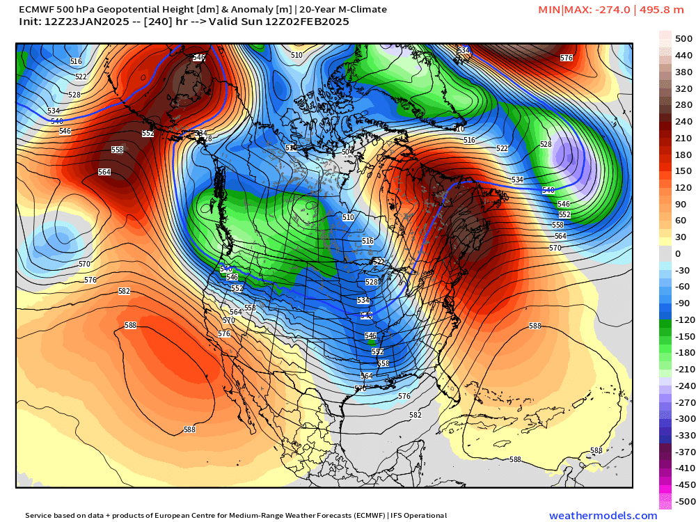
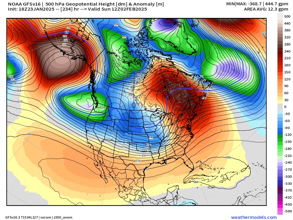
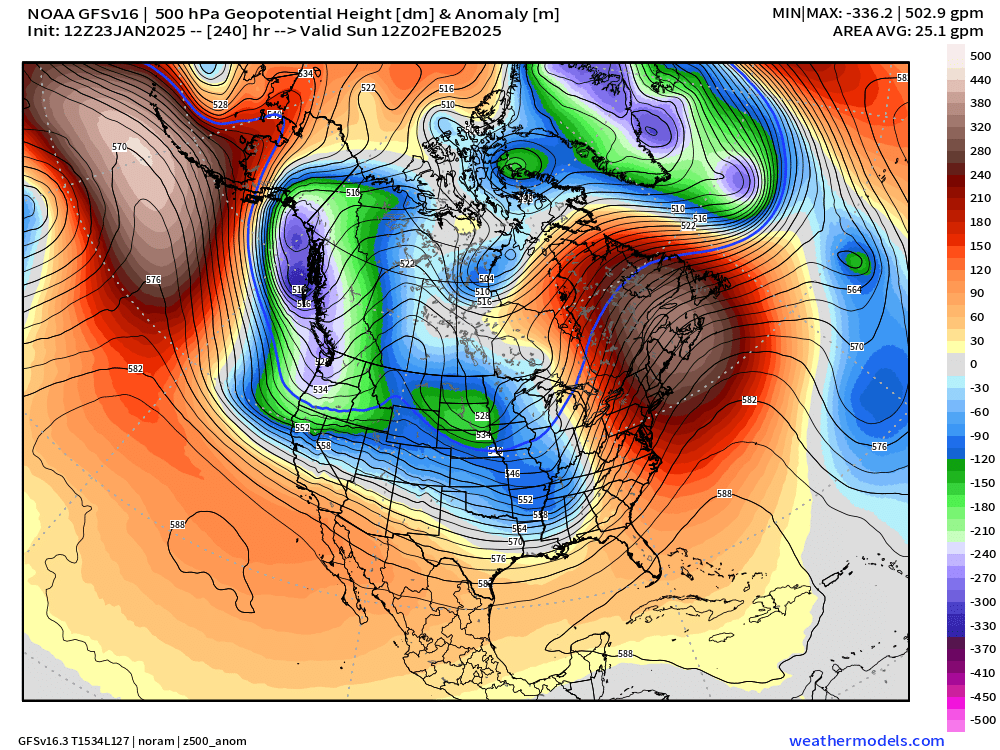
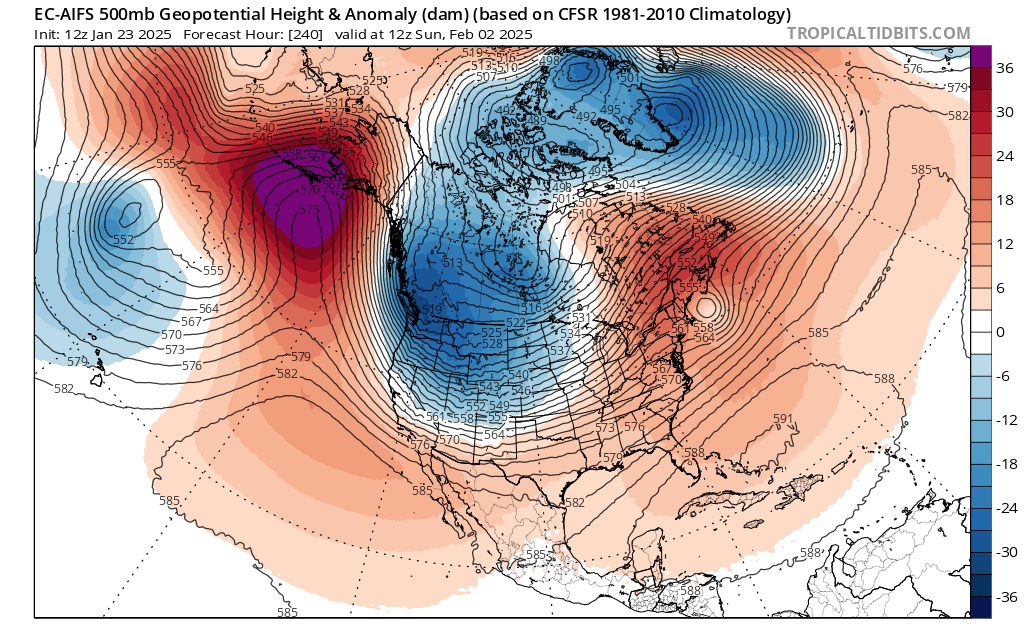
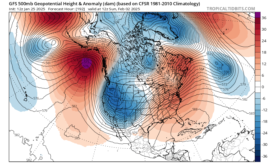
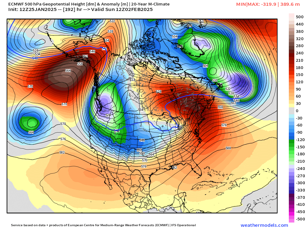
Next Sunday (Feb 2nd) models seem to be honing in on the colder arctic air moving MUCH closer to us, and possibly directly over us. When it’s more than 7 days out like it is at the moment, we look for consistency and trends. Below is a compilation of multiple model runs from the past few days showing the weather pattern up around 18,000 feet up in the atmosphere for Sunday morning February 2nd. Blue and or green shading is much colder than average, and the warm red and orange colors are just that – warmer than average lol… 😉
Definitely a clear trend for colder air here in Oregon, but how far south and how far west or east it goes will have a profound effect on our weather. Some of the solutions you see above would give us nothing but cold rain. Many of those solutions would put us in one of those tricky snow shower setups, and some of those would give us a full on snowstorm and or arctic blast. Odds are increasing that we will see something wintry, but still a little too early to get overly excited.
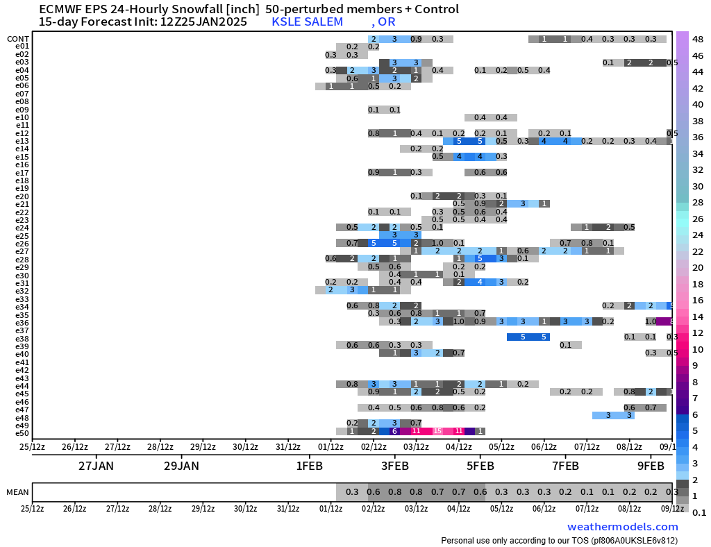
One more little piece of evidence telling us that something snowy might be heading our direction is this final chart which I’ve shared before. Each horizontal line going from left to right is a possible outcome for how many inches of snow Salem could see on those dates (the dates are located along the bottom). This model tends to overdue precip totals a little bit, so pay attention to lines showing 2 or more inches of snow.
Typically during wintertime I will see maybe one to three lines showing snowfall, but when I start counting 20+ then I really start paying attention. Lots of time for things to change of course, but keep this one on your radar. In the meantime, stay safe, and enjoy the sunny and chilly weather!
As promised, this week has been very winter like with lots of rain, chilly temperatures, and at times, gusty winds. Below is a county map of Oregon showing total rainfall over the past 7 days. Most of the Willamette Valley has picked up around 3 inches of rain since last Saturday!
The other big change over the past week has been the well advertised increase in mountain snow. Hoodoo had a 15 inch base early this afternoon with 4 to 8 inches of new snow expected this evening through Sunday morning.
Looking ahead
Tonight: Showers increasing through the evening. Lows tonight in the mid 40s.
Sunday: Mostly dry with some a little bit of sun, and only a slight chance of a shower. Highs into the upper 50s.
Monday: Rain returns as a quick moving cold front sweeps in from the northwest. PM sunbreaks and showers. Highs in the mid to upper 50s.
Tuesday (Election Day): Highs around 57° with a fair amount of sunbreaks, and a slight chance for a brief shower or two.
Wed – Fri: Lots of fog. This time of year can be incredibly foggy, especially after having so much rain. Expect widespread fog each of these three days. Lows will likely bottom out in the 35 to 38° range and highs 49 to near 50 degrees assuming we get some afternoon sunbreaks. Lows could dip to freezing for areas that receive a little more clearing at night.
Next weekend: Rain appears likely, but obviously subject to change being several days out.
No big storms on the horizon at this time, and nothing real out of the ordinary for early November. No signs of any big warm rainstorms to wash away our early snowpack either as temperatures remain a little cooler than normal in the coming days.
October 2024
October may have ended on a cooler note, but overall it was quite mild being 2.8 degrees warmer than normal. As far as precipitation goes, we finished the month above average with a total of 3.8″ to kick off our new water year. Average for October is 3.47″. Over 2 inches of that rain fell during the final week of the month.
The coming week is going to feel extremely winterlike as three separate storms move through bringing periods of widespread rainfall, mountain snow, showers, a few thundershowers, and highs in the 50s all week long.
Below is a map showing the 500mb heights compared to normal for Sunday through Thursday of this coming week ( a five day average). Basically, this is a reflection of the weather 18,000 feet up in the atmosphere. Blue means lower pressure and colder than usual, and the orange and red colors indicate higher pressure and warmer than average conditions.
This is a classic La Nina pattern with the cold trough centered directly over the pacific northwest, and it’s the reason why we tend to see more snow opportunities during La Nina. Here we see a large ridge of high pressure over the Pacific Ocean to our west, and on the backside of that ridge (where Oregon is located at) cold storm systems slide down from the gulf of Alaska. This same pattern in December through February would bring snow chances to Salem, but since it’s still October, we are “off the hook” for them moment. Just watch for this pattern to reoccur as the winter goes on. For now, let’s focus on the week ahead. Here’s the next 7 days with additional details below:
Saturday: Lots of clouds with showers at times all day long. High of 64°. A much stronger cold front moves through Saturday night bringing steady rain (heavy at times), some gusty winds to 30mph, and colder temperatures. Sunday night could be a real soaker!
Sunday: Showers and sunbreaks. A few showers could be quite heavy. A brief thunderstorm is also possible along with small hail.
Monday: A second day of showers and sunbreaks as we remain under a cold upper level low. An chilly unstable airmass coupled with sunbreaks will provide more opportunities for downpours and thundershowers.
Tuesday: Perhaps one of the driest days of the coming week, but no less winterlike. Lows will start out in the upper 30s. Brrrrrrrrr!! Widespread fog is also fairly likely. Fog or no fog, some afternoon sunbreaks should pop through. While the vast majority of Tuesday should be dry, I can’t rule out a stray shower or two, especially near the Coast Range or Cascade foothills.
Wednesday: The day begins chilly and dry, but with increasing clouds. Steady rain moves in during the afternoon.
Thursday: Another day of showers and sunbreaks with a few stronger thundershowers mixed in.
Impacts on day to day life
This coming week will be soggy, cold, gray, and very winter like and that may feel like quite a change from what we have seen lately. The second impact this week is the potential for localized street flooding with some of the stronger thundershowers and downpours this week. I looked back at my own personal weather records and I see October is one of the top months for localized flooding due to the combination of both heavy rain and clogged street drains. This week could feature more of that.
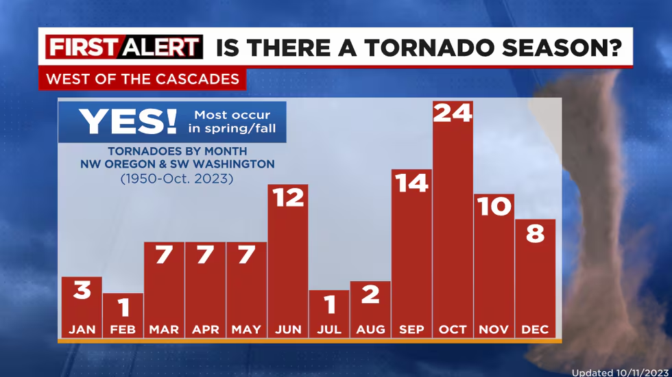
Third, don’t be surprised to see a report or two of a funnel cloud or weak tornado between now and this time next week. Oregon is not known for tornados, but we do have a sort of “tornado season” when weak tornados or funnel clouds become more likely. The active and chilly pattern we will be in this week is conducive to seeing funnel cloud activity.
The image below is barrowed from Mark Nelson over at Fox 12 Oregon (the best weather team in Oregon other than yours truly haha). It shows our “tornado season” (if we can call it that) peaks in October. Keep in mind the tornados we have are almost always extremely weak compared to those found in Texas and the Midwest, but still, I found this a little interesting.
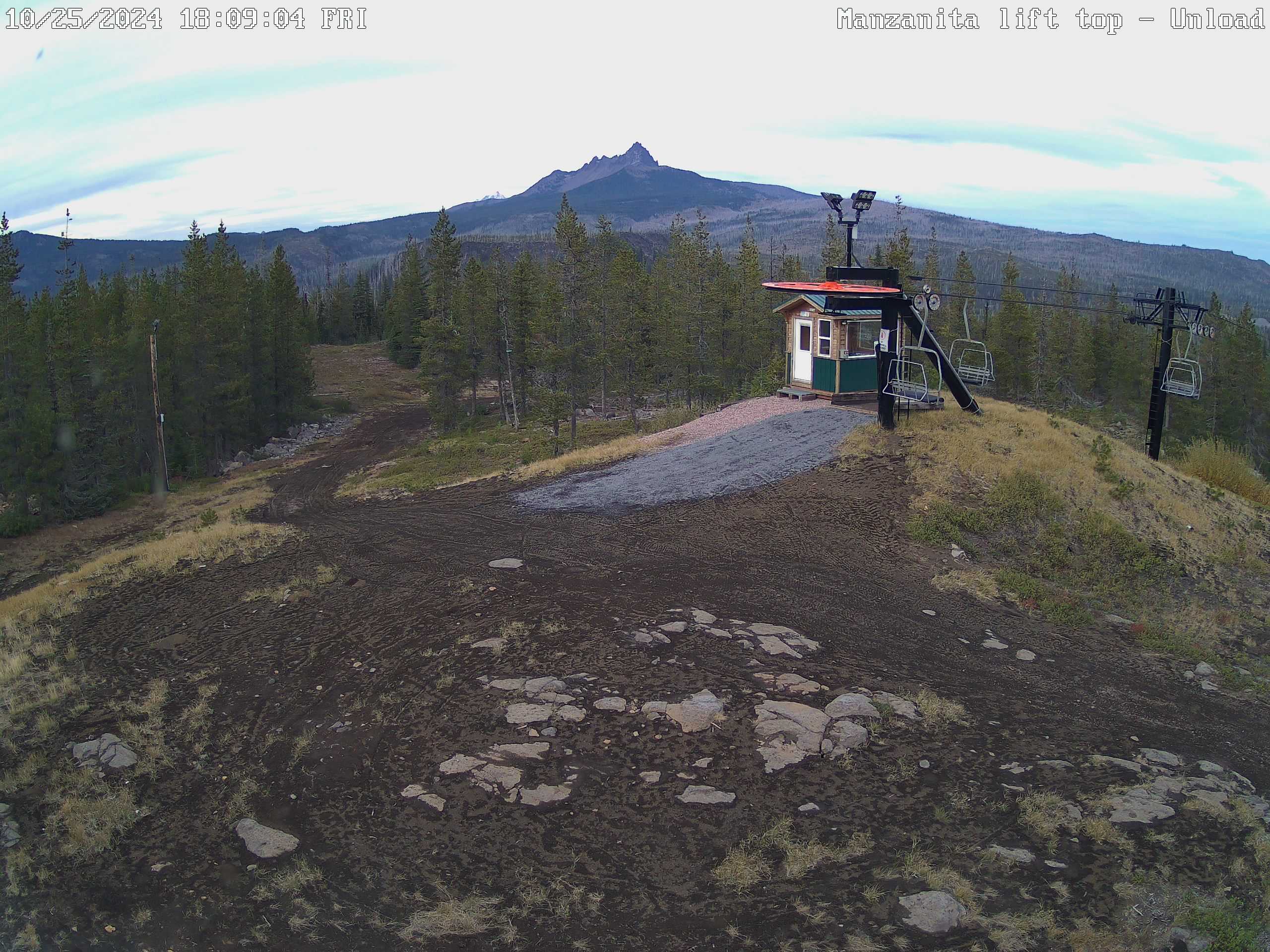
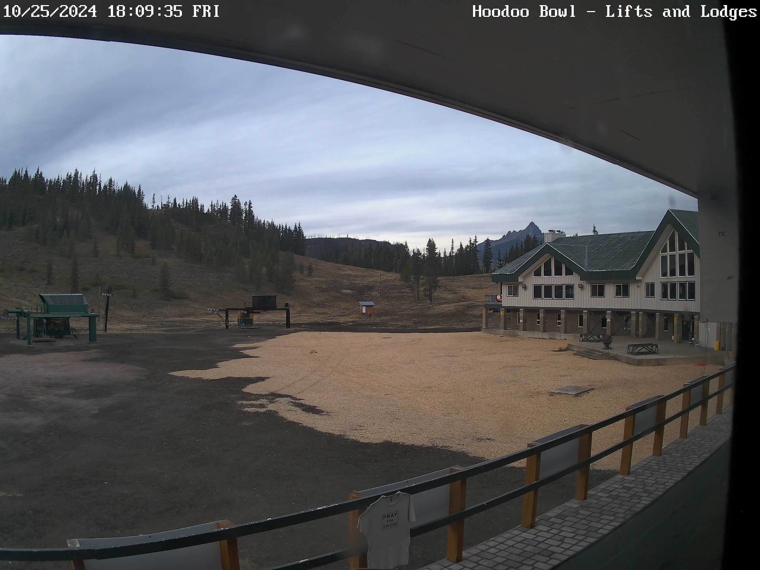
Finally, the Cascades will see multiple rounds of snow this week. Monday and Thursday will probably be the snowiest days up in the passes with 4 to 8 inches Sunday night through Monday, and an additional 4 to 8 inches Thursday. Let’s check on how these locations look a week from now, but imagine they will be pretty wintry by then!! 🙂 The image on the right is the lodge at Hoodoo, and the left image is the top of the Manzanita chairlift at Hoodoo.
If you want the forecast, then read this top portion, but if you’re in a reading mood than check out the rest of this post. It’s always an exciting time of year as a forecaster around here. Fall is upon us, we are entering into our storm season, and soon we will be entering into the time of year when snow and cold also become possible. I have a wide gamut of details and fun facts below, but first, the forecast.
Expect showers and sunbreaks on Thursday with increasing amounts of sun later in the day. Highs in the upper 50s to 60°.
Friday looks dry and partly cloudy. High of 59°. Saturday should be a super nice fall day. Patchy fog to begin the morning followed by afternoon sunshine and highs in the low 70s.
Sunday should also be quite mild and nice, and will likely top 70 degrees again. This weekend will probably be our final set of 70 degree days for the season, so enjoy them!! Rain moves in Sunday evening and lasts through Monday. Highs on Monday in the mid 60s.
Tuesday and Wednesday of next week look dry, with sunny afternoons, but chilly and possibly foggy mornings. Lows will also be the coldest they have been all fall down to the upper 30s.
No big storms, no major cold spells, and nothing unusual for the time being.
Weather statistics and the winter ahead
October 1st is the beginning of the new “weather year,” also known as our “water year” for most locations in the western US. It makes sense to have our rainy season fall into one “year” for record keeping as opposed to interrupting our rainy season every January 1st at the start of our calendar year.
To begin with, I wanted to see how this past year compared with previous years in regards to both precip and temperatures. I also wanted to provide a few thoughts for our upcoming winter season.
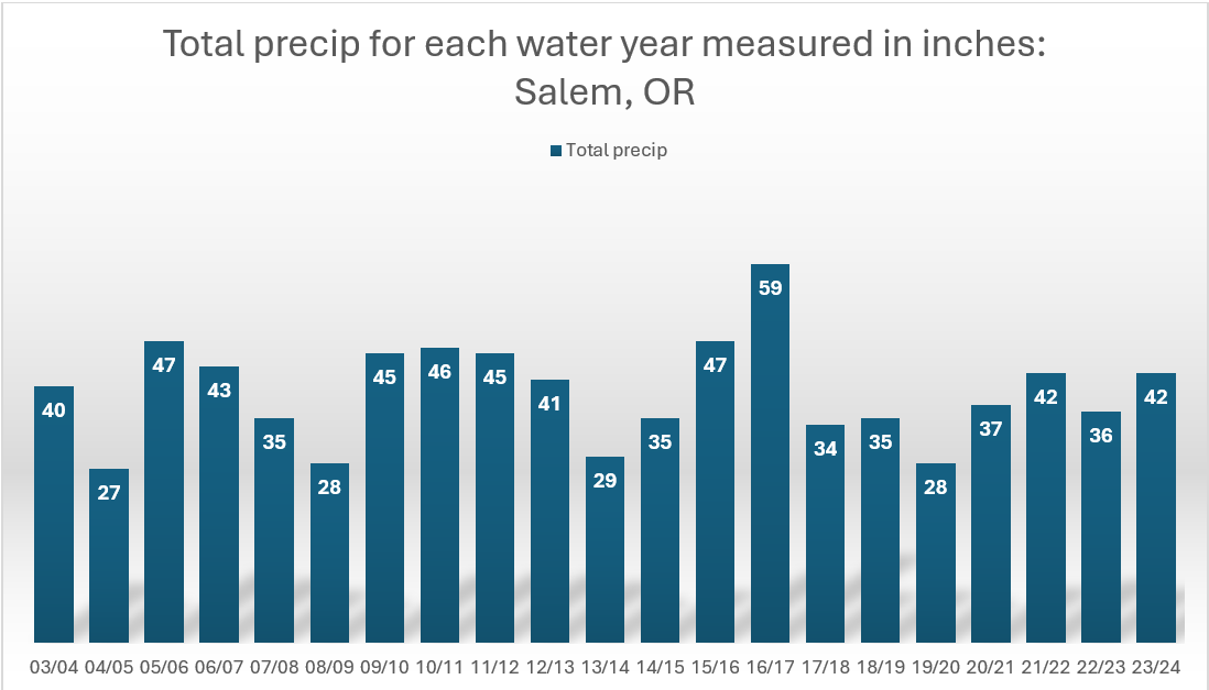
Let’s start with the precipitation. Check out this graph showing total precipitation for each water year in Salem Oregon going back to the winter of 2003/2004.
The primary take away is that Salem is rainy lol! It is interesting though how we get our rain one way or another year after year after year regardless of how much the climate may be changing. In fact, one could go back to the late 1800s and early 1900s when our official records began, and you would see extremely similar totals.
For the time being, there is no trend in any direction with precip. There are a few dry years mixed in where we didn’t reach 30 inches, but notice how they are always proceeded by and or followed by a wetter year. Our rain is what keeps this area so beautiful, so remember that later this winter when the rain starts to grow old.
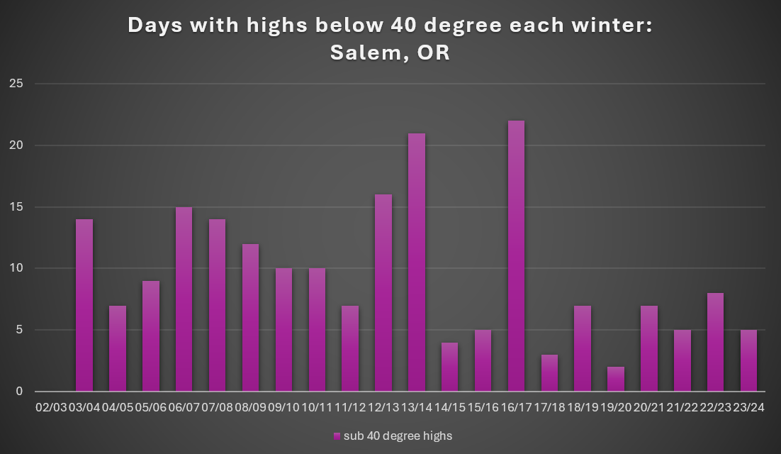
Next let’s look at the total number of days per winter where highs stayed below 40°.
The first thing to point out is the data for 02/03 is not missing. That sad, sad winter really did not have even a single sub 40 degree day. I remember that pathetic winter as a kid. Not even one snowflake fell at our house the entire winter. A huge disappointment for someone who loves snow so much.
The second thing I noticed was how it’s been awhile since we have had a really cold winter, and by that I mean a winter where we experience at least 10 or more days below 40 degrees. Sure, last winter provided us with some extreme cold; however, looking at the total number of days below 40 reveals just how brief and isolated the cold spell was in what was actually a very mild winter. Compare last winter to the winter of 2016/2017 which delivered snow and ice multiple times from December through March, and had a grand total of 22 days with highs below 40°. Perhaps this winter is the year we finally see some prolonged cold again.
The third item I wish to point out is the fact that three of the four lowest totals on the chart were El Nino winters. Currently, we are entering a weak La Nina (more on that below), so I believe we will see at least several days this winter where the thermometer does not reach 40 degrees.
Overall there’s definitely more variability when it comes to cold weather around here than with the precip, but now it’s time to unburden ourselves from what has been. Did I use that phrase correctly??? Anyway, time to talk about what could be in store this coming La Nina winter.
Our up coming winter
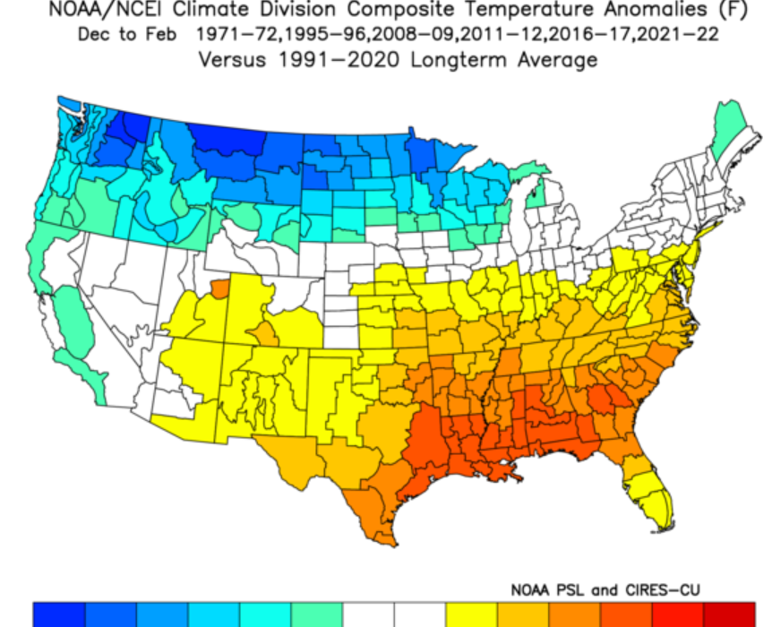
We are entering a weak La Nina which means the waters off the west coast of South America are cooler than normal. There are a few other regions of the ocean I look at when finding analog years to compare to. Generally, I look for past winters which had similar ocean conditions as it’s the oceans which really drive our weather.
The map below is a composite of surface temperature anomalies for all the years which had similar ocean surface temperatures. Darker blues are much colder than normal areas, and the red and oranges are much warmer than normal areas.
There is a clear signal for colder weather in the pacific northwest during December through February. This tells me we have an elevated chance for colder weather and longer lasting cool weather too. No guarantees, but the deck is stacked in our favor for cooler weather.
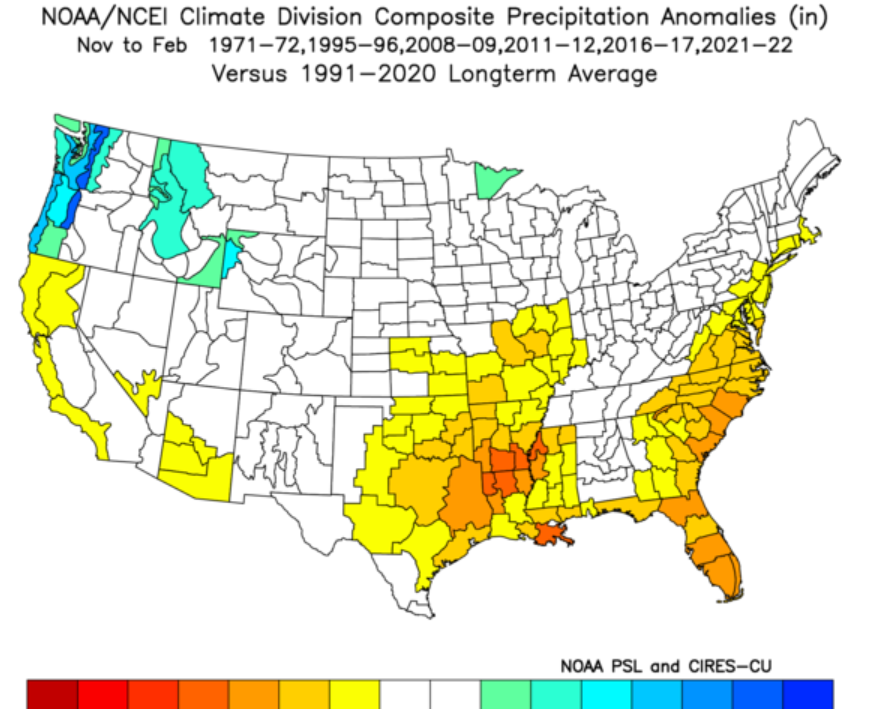
Next we have precip anomalies for the same set of previous winters. There is a clear trend for western Oregon to experience a wetter winter when all is said and done.
Big take aways
I expect our upcoming winter to provide more opportunities for lowland snow. This is something which can be misleading. More opportunities doesn’t always equal lots of snow for a given location in the Willamette Valley. It just means you will likely see snow in the forecast more often than compared to last winter (an El Nino winter), and with those increased opportunities comes increased chances of scoring some decent snowfall.
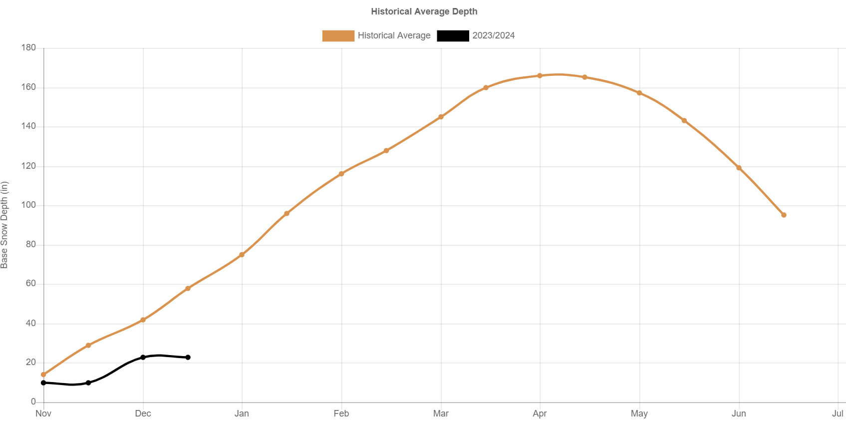
Last winter really was quite mild with only one big exception. That exception of course being the extremely cold and intense winter storm we saw in January. For nearly 5 days our temperatures stayed below freezing. During that time frame we experienced the sleet/ice storm followed by a few days of very cold weather and then a brief freezing rain event that Tuesday; however, the rest of the winter was fairly mild both in the months leading up to that storm, and in the weeks to follow. I distinctly remember sharing this photo at the end of last December revealing the dismal snowpack at Timberline due to the warmer weather.
This leads directly into my second point which is I expect the ski season and mountain snowpack to do fairly well this winter. La Nina keeps us on the cooler side of the jet stream more often allowing the snowpack to build up at a better rate. The chart above reminds us just how awful the snowpack was for much of last winter, and that was due to us being on the warmer side of the jet stream for a majority of the ski season.
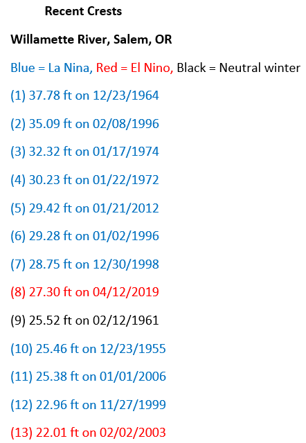
The final piece (which I’ve shared before) is how a La Nina winters often provide us with the correct setup for major flooding on the Willamette River. I’m not predicting it, but it’s also not a coincidence that the vast majority of our highest river crests on the Willamette have occurred during a La Nina winter. I have shared this before, and it’s still up to date I believe.
It’s also a really good reminder to be ready and prepared for a natural disaster as much as possible, and assume you may be on your own for a period of time following a flood or any other type of disaster for that matter.
The main message is expect more opportunities for snow, higher chances of seeing cold weather, a decent ski season and mountain snowpack, and an elevated chance at seeing major flooding.
Stay safe, stay healthy, and enjoy the weather regardless of what it brings! 🙂