Thunderstorms round two

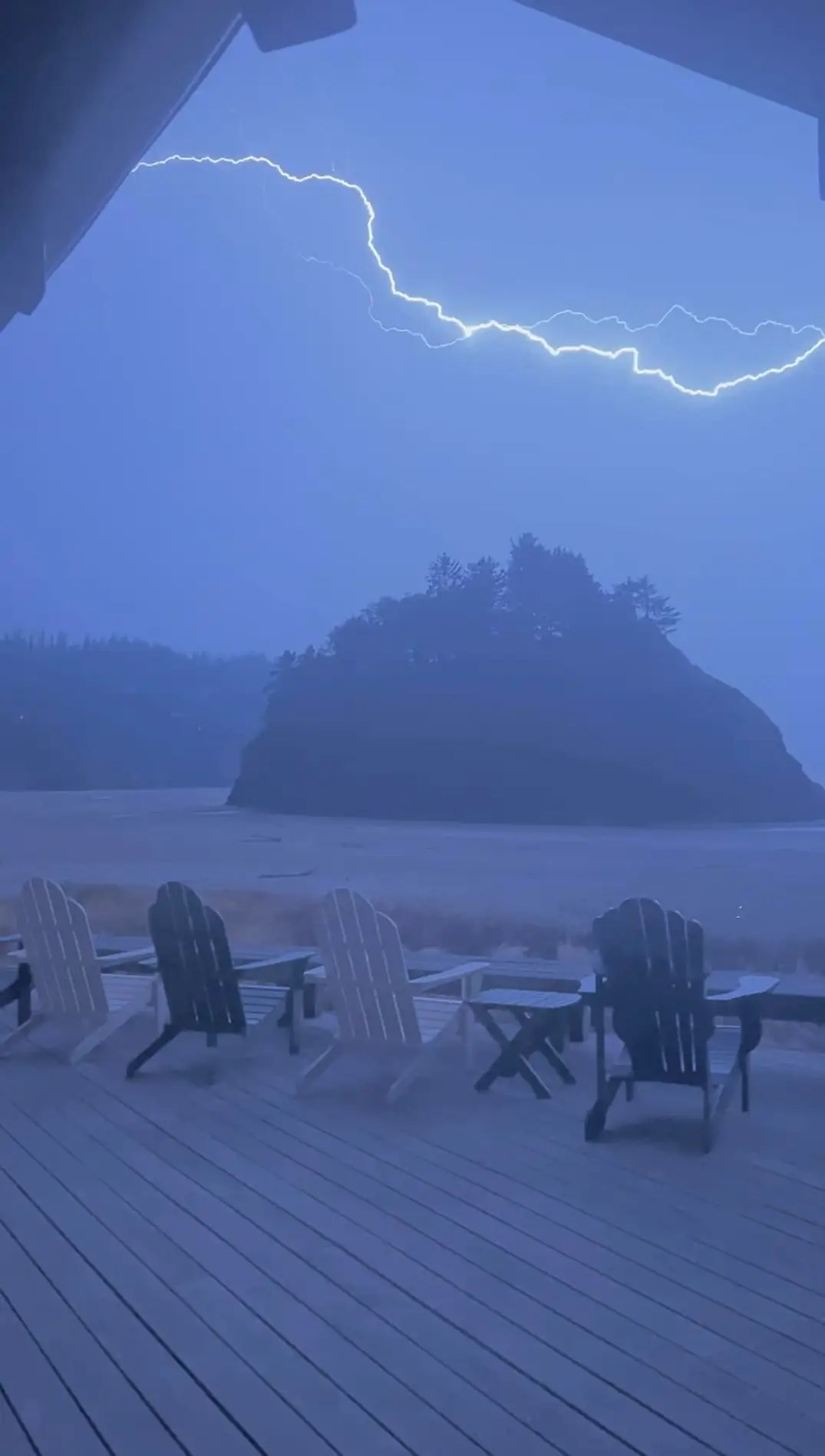
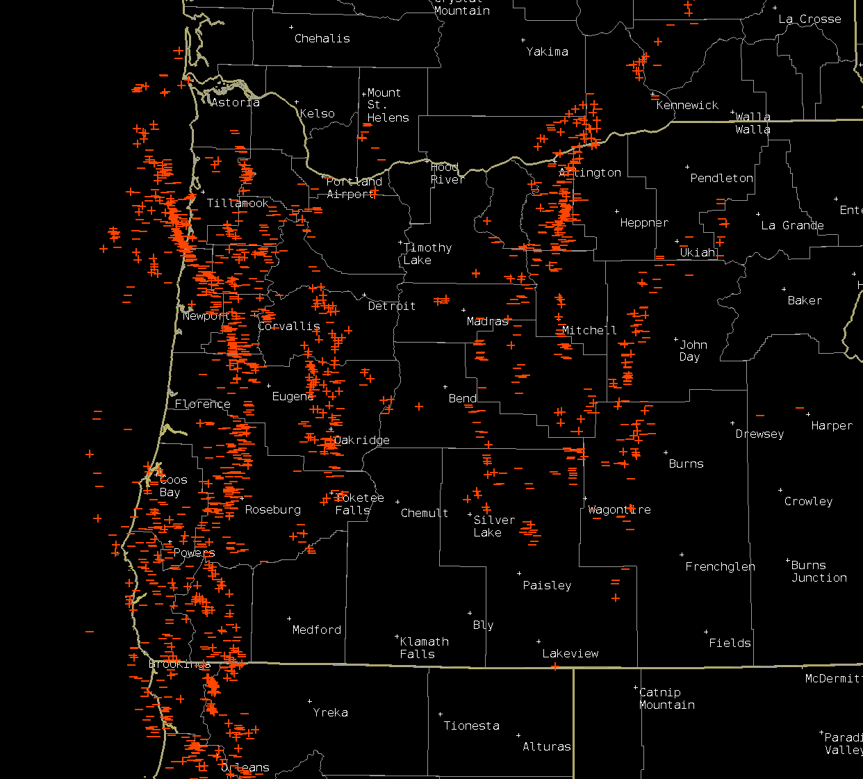
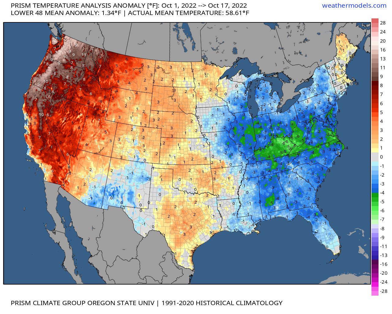
We have a fairly good thunderstorm pattern setting up this Saturday. It’s rare to see two decent thunderstorm chances within 10 days of each other around these parts. More on storm chances in a second. Before I move on, I want to acknowledge the significant rainfall we received with the storm Thursday. Check out the rainfall totals from over the past few days.

Remember you should be able to click on images for a closer view. 🙂

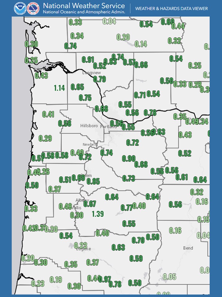
Well over half an inch of rain fell across western Oregon Thursday and Friday. It appears the hard working crews out there battling wildfires burning in the Cascades made a lot of progress just in the past 48 hours thanks to the soaking rain we received. Very good news!! Now we can move onto the forecast. 🙂

Highlights

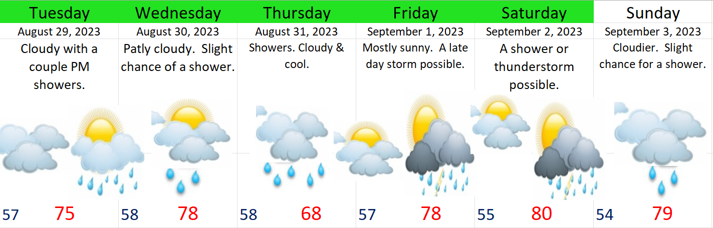
Saturday: A fairly warm and sunny day will eventually give way to some late day showers and thunderstorms. The majority of the action will take place later Saturday afternoon through Saturday night. Similar to last Thursday, not everyone will see a bunch of lightning and thunder, but chances are pretty good that at least some of us will experience stormy weather. These storms also have the potential to drop a lot of rain, and even some hail this time in addition to the lightning and thunder. This forecasted radar image shows some heavier showers and thunderstorms crossing the Mid Willamette Valley right around 9PM.

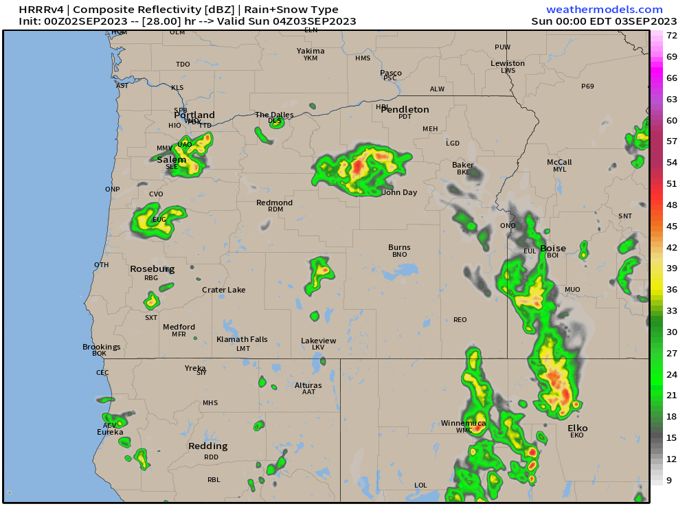
Don’t take the actual positions of the storms or time too literally. The main idea is some of us between Albany and Portland will see storms Saturday and Saturday night at some point between roughly 4 and 11PM.

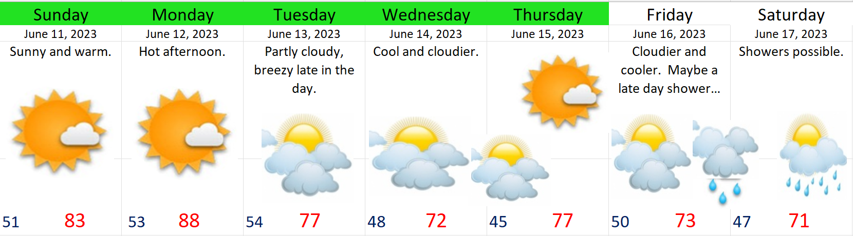
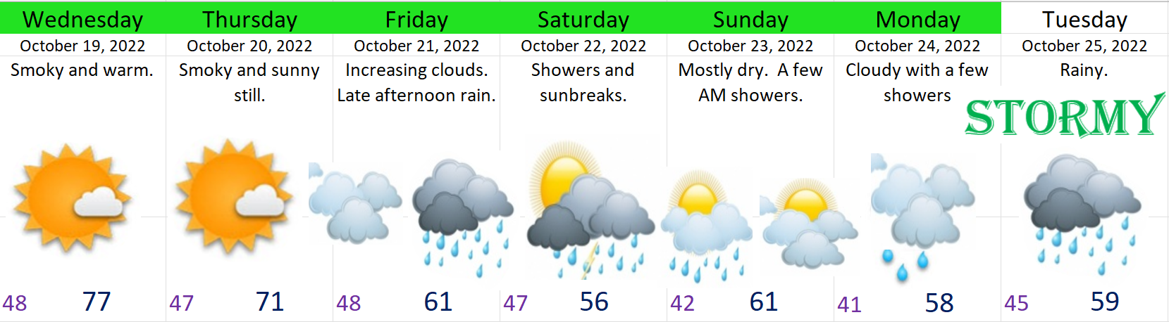
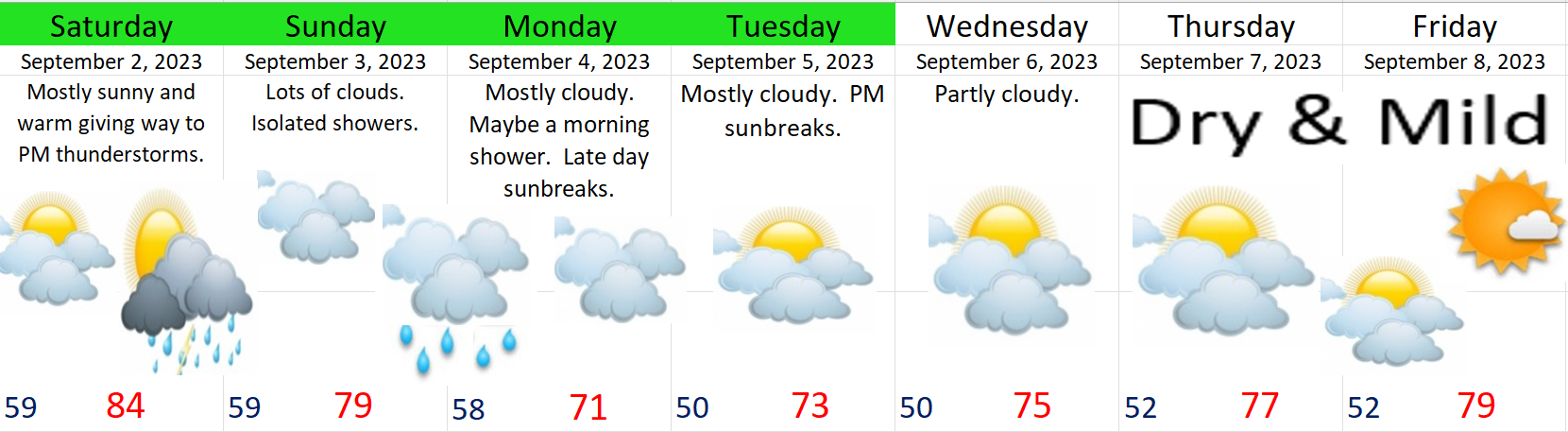
Sunday: Lots of clouds with a couple of showers late in the day.

Monday: Slight chance for an AM shower or two. Mostly cloudy with sunbreaks later in the day.

Tue – Fri: Varying amounts of clouds and sunbreaks with highs ranging anywhere from 73 – 79° depending on cloud cover each day. Pleasant late summer/early fall weather – albeit maybe a little on the cloudy side at times. Fall is definitely around the corner! Enjoy the exciting weather if you’re “lucky” enough to see a storm, and stay safe!

End of August forecast

For a number of us, this past Thursday night provided some of the best nighttime thunderstorms we have seen in a few years with numerous lightning strikes. Here is a great lightning strike which was caught by Jessica Ward looking over Proposal Rock in Neskowin last Thursday night

This map shows lightning strikes (both negative and positive) from Thursday night and Friday morning. It’s very typical for some of us to experience nothing while others see the storm of the decade. Generally speaking, the west side of the Willamette Valley saw the most action. You should be able to click on the image for a better view. If you are curious about the differences between negative and positive strikes, then follow this link for more info: Different types of lightning

Moving ahead, the next seven days feature multiple shots at precipitation (actual rain) as a cool and wetter pattern takes shape over us. In fact, today is already feeling rather fall-like with the grey skies and cooler temps. Here’s the extended forecast.

Highlights

Tuesday: Mostly cloudy with a few showers – especially late in the day.

Wednesday: Slight chance of a shower or two, but a mostly dry day. Drier than Tuesday. Highs close to 80°

Thursday: Showers and more widespread light rain. Will be the coolest day since June!

Friday: Warmer with more sunbreaks, but a chance for PM showers and thunderstorms.

Saturday: A near repeat of Friday, but with a tad more sun and slightly warmer high temps.

Sunday: Lower confidence. Currently, it’s looking cooler with possibly another shot at some rain.

No signs of the heat returning, but we all know September can feature pretty warm temps, so we will see what happens. Certainly much different than last year when we saw our dry summer heat and wildfires drag on right into the middle of October!

Oppressive heat

The heat is on, and we still have a few more days of intense heat to go. The pic below showcases the extremely hot high temperatures cities from around the northwest saw Monday.

The next 7 days

Highlights

1.) Brutal heat continues for a few more days. The yucky smoky/hazy skies will also stick with us for much of the week. Overnight lows tonight and tomorrow night will struggle to even reach 70°.

2.) The heat lets up a little bit on Thursday with highs in the mid 90s – which is still extremely hot. Friday will be a bit closer to normal summertime weather with highs in the upper 80s.

3.) Saturday should be quite a bit cooler with partly cloudy skies.

4.) Sun & Mon: We might have a shot at some actual rain! Yes, showers are possible for Sunday and Monday. I still have those days highlighted yellow due to a higher level of uncertainty, but as of right now, I’m forecasting at least the chance for showers those two days.

There you have it. Do the best you can to stay cool and safe!

The middle of summer

It may be hard to believe, but with the exception of a few brief rainy days, western Oregon has largely been dry and warm since mid April. We are now in the heart of summertime here in the Willamette Valley. We have one item to address and that is a chance for some light showers next Monday and Tuesday.

Summer in Salem is a reliably dry time, but it’s normal to have a drippy day mixed in every great once in awhile, and that’s pretty much what is happening for Monday and Tuesday of next week. Here’s our extended forecast:

I don’t have raindrops on Tuesday, but don’t be shocked if a few fall from the sky that day too. Monday however, will feature the primary shower threat. Notice it’s right back to summer afterwards.

Sometimes it can be interesting to look back into the past for a glimpse at the larger picture as it can offer us a different perspective. This first chart shows total rainfall for each July here in Salem going back to 1970.

The wetter Julys back in the 70s and 80s versus the consistently dry Julys since the 90s really stands out to me. If you are a long term resident of Salem, than maybe you remember Julys being a little bit “rainier” than what we have seen lately, and you would be right. Between 1970 and 1993, we had six years where our July rainfall topped the one inch mark, but we have not topped one inch since ’93 – going on 30 years of Julys having less than an inch of rain. Seems like a drying trend, and to it is, but were Julys always wetter in the past????

Check out this next chart which shows total July rainfall by decade:

Seems like the 70s and 80s were more of an anomaly, and not so much “the usual.” The Julys of the 1950s saw a cumulative rainfall total almost identical to the total saw in the 2010s. July has always been (in my opinion) the peak summer month. Days are long with daylight stretching well into the evenings (which I love), and the weather is reliably dry and warm. August of course is a great month too, but those late evenings start to shorten a bit, and of course there is the “well known” idea that it always rains during the State Fair. We really are in the heart of summer right now. The cool and possibly drippy downturn next week will be very short lived, and before anyone knows it, we will be right back into the 80s. Enjoy and stay safe! 🙂

Dry summer like weather

Summer arrived super early this year. We have hit or surpassed the 90 degree mark 5 times so far this spring with the first occurrence happening back on April 28th when we hit 91°. We reached it 3 days in May with two of those days topping out at 93°F. I remember those days well as we cooked in our classrooms at work, and then just last week we hit 91 on Tuesday. Overall May was a very warm month ending 4.2° above normal!

The more concerning issue has been the extremely dry weather. Since May 6th, we have only seen a sprinkle here or there, but nothing widespread. If we don’t see some good soaking rains soon, it could be a really tough summer. Salem ended the month of May with only 27% of our usual rainfall! Adding more evidence to the case, check out this map showing total rainfall over the past 30 days.

Western Oregon is one of the driest locations on this map. Heck, even Death Valley, California has picked up more rain than us during this span of time, so you can see why we could be in trouble if we don’t get some good rain soon.

Extended Forecast

We will see if it actually rains next weekend, but for now enjoy the warm and dry weather the best you can. 🙂

November 2022 and the weekend

The forecast

Periods of rain and breezy conditions will prevail through Sunday. This is typical northwestern Oregon rain. Nothing real wild.

Temperatures will stay chilly though which means the incredibly healthy Cascade snowpack will continue to grow. Check out this image showing our current water equivalent snowpack percentages by region.

The entire state is running well above normal for early December. Hoodoo Ski Area currently has 42″ of snow at its base. I was just up in the Cascades last weekend and I can attest to the fact that there is a lot of snow up there already. The storms this weekend will dump another 18 to 24 inches of snow through Sunday night. Snow levels will also stay below the passes the vast majority of the time, so expect snow covered roads if you’re heading up there.

Next week is going to be cold. No clear signs of moisture interacting with the cold yet; however, this will almost certainly be the coldest weather we have seen this winter. I’m watching things closely for sure! 🙂

November 2022

November stood in stark contrast to the extremely warm weather we saw in October. Check out this comparison between October and November for temperature departures from normal.

Highlights from the month include the little bit of wet snow which fell on the evening of the 6th. Slushy accumulations of less than an inch were reported in the higher hills south of Salem as well as areas near Corvallis.

The wettest day of the entire month actually took place just two days prior on the 4th with 1.65″ of rain falling in just 24 hours.

For almost 3 weeks nothing really happened through the majority of the month other than it was freezing cold, and dry.

The month closed out with a bang as a strong cold front moved through. Salem recorded a wind gust of 44mph and picked up another inch and a half of rain while the mountains received a couple feet of snow. For you guys who enjoy statistics, here’s a quick recap of November 2022.

That’s all for now. Have a fantastic weekend and stay safe out there!

Incoming

It’s awful that we are having to deal with fires and smoke in the middle of October, but here we are. Of course some of these fires were human caused, so they are not so “wild.” With that in mind, it is true that regardless of the cause, fires would not be burning out of control like this if our regular early fall rains had showed up on time.

I’ve been mentioning it for awhile now, and it’s finally almost here. The transition from warm, sunny, and dry weather to cool, stormy, and rainy weather will be quick and it’s coming this weekend! Before we dive into anymore details, take a look at how the entire country is doing in regards to temperature so far this month.

Map showing temperature departures for the month of October compared to average.

The pacific northwest is both metaphorically and literally on fire with the majority of locations running 8 to 10 degrees warmer than normal! Meanwhile the east coast has already started winter. Do you realize that parts of Florida dipped below freezing this morning? Back here in Salem we haven’t even cracked 40° yet…..

This next chart is one I enjoy using during the fall and winter months. Time moves from left to right with each horizontal line representing a possible outcome. In this case it’s showing how much rainfall is expected here in Salem. What really stands out is that after Thursday we are done with the days and days on end of reliably dry weather. The rainy season is definitely upon us meaning our prolonged summer is nearly over. There will be no gradual transition into wet season this year. It’s arriving late, but arriving in full force very soon.

Here’s the next 7 days

Highlights

Wed & Thu: Smoke will continue to plague our air quality both days as we continue to stay in a dry and warm pattern.

Fri: Dry with increasing clouds. Rain moves in late afternoon/early evening.

Sat & Sun: Showers and periods of rain with a few sunbreaks. Could see some hail and maybe a rumble of thunder too. Meanwhile the Cascades will actually see their first dumping of snow over the weekend with 4 to 8 inches falling by Sunday night. Sunday will be much drier with sunbreaks and just a few isolated showers around.

More storms roll in next week continuing the stormy weather pattern.

Lastly, it is going to be yet another La Niña winter meaning I expect our winter to overall trend wetter than normal with elevated chances for both flooding and valley snow. Not guarantees; however, La Niña winters favor rainier, snowier, and stormier weather than a typical winter. We will see what happens. Here’s a look at the current sea surface temperature anomalies. The classic La Niña signature of cooler than normal waters off the coast of South America really stand out on here.