October 2020

October 2020 is done. Just two months to go before 2020 is also in the bag… The highlights for the month would probably be the consistently dry weather we saw (24 dry days this month), and to a lesser extent, the couple of storms we had early in the month which brought wind gusts of 35 to 40mph.

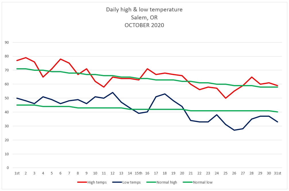
This graph shows Salem’s actual high and low temps per day along with the average high and low temps for October.

Temperature

Warmest high temp was 79°  October 2nd   

Coldest high temp was 50°  October 25th  

Warmest low temp was 54°  October 12th

Coldest low temp was 27°  October 26th

3 days with lows at or below freezing.

Precipitation

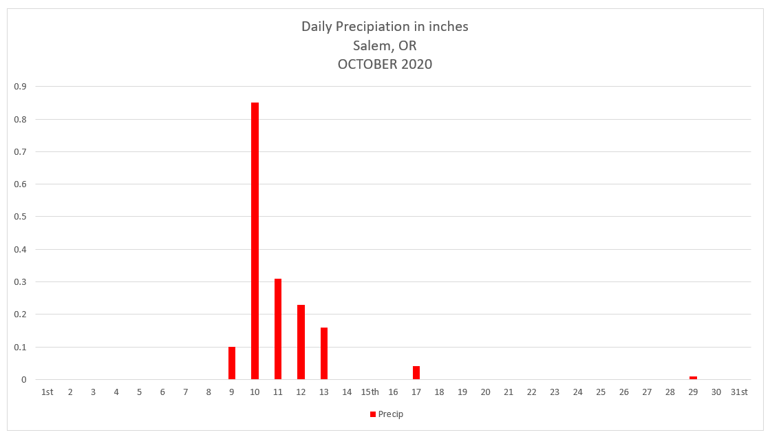
Salem saw rainfall on 7 days during October with .85” of rain falling on the 10th making that the wettest day for the month.

October 2020 Summary

Despite having a number of warmer than normal days with lots of mild afternoons, October ended at only 0.77° above average thanks to the cooler weather, and more specifically the cold mornings we experienced the last several days of the month. As far as precipitation goes, October 2020 saw only 56% of our normal precip making for a much drier than normal month.

Looking ahead

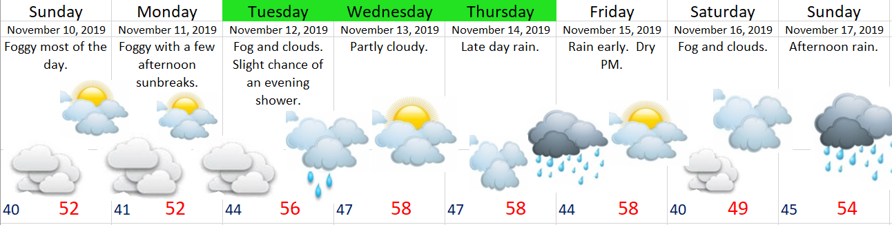
November is our first real month of our winter/storm season. It’s the second wettest month of the year beat out only by December. As far as valley snow goes, November snow is quite rare. In fact, 2010 was the last time Salem recorded sticking snow in November, and the time before that was in 2006, so perhaps one could say we are due for a little this year. 😉

Even more overdue and more likely than November snow is a wet November. The last really wet November occurred back in 2012. Every November since then has been either right around average or drier than normal. Last November was one of the driest on record with less than one inch of rain for the entire month! I have a feeling this month will be a bit more active….

November rainfall per year for Salem, OR going back to 1990.

May 2020 and look ahead

May 2020 is over and it ended up wetter than average, and despite the extra rain, Salem was still 1.6°F warmer than average for the month.  I graphed out the total May rainfall for each year going back to 1997.  The dark blue bars are years when May ended with above normal precipitation, so by process of elimination you should know what the yellow bars mean.  😉

May Salem rainfall graph

One could say that Salem was “overdue” for a wetter than average May considering our last wetter than normal May occurred back in 2013.

Look ahead

Unfortunately, I have bad news for those of us who prefer/enjoy sunny weather this time of year.  Keep in mind this week will still be mostly dry; however, it won’t be all that warm.  Nicest days this week will be Wed & Thu. 

Details 

Mon:  Basically dry with lots of clouds around.  Slight chance of a sprinkle/quick shower.  Highs in the mid – upper 60s.

Tue:  Gray and wet – especially during the afternoon.  Highs around 65°.

Wed:  Partly cloudy with highs in the mid 70s.  Very slight chance for a shower.

Thu:  Partly cloudy.  Highs around 77°.

Fri & Sat:  Showers return along with cooler temps.  Highs 63 – 67°.

Peace out and have a good week!

A quick throw back and a wild wintry weekend

Greetings!  It’s been quite some time since I last posted.  Being a first year teacher has been a wonderful experience, but it sure does take up a lot of time.  Anyway, before looking ahead to what should be an exciting weekend, I want to take a minute to review some highlights from January.  January 2020 has gone down as one of the warmest ones we have ever seen here in Salem.  The month ended 4.2 degrees above normal which is significant.  For a comparison on the other side of the scale, the cold February we had last year was 4.39 degrees below normal.

And how strange that for the 3rd year in a row we have seen a warmer than normal January only to have some sort of snow event in February or March.  2017 was the last time we had snow in January.  I’m currently working on a couple of graphs and I’m not finished with the data yet, but it appears as though February has been a snowier month than January during this past decade.  Interesting don’t you think???

Now onto something I think you will find far more interesting – we have a chance for snow now through Sunday night.  Details below:

Tonight through Saturday morning:  Here’s what the satellite from around 4:40pm looked like.  You can see a nice comma shaped storm off the Oregon coast.  This sucker is going to send moisture over us tonight while pulling in cold air in through the Gorge.  If things come together just right there is no reason why anyone couldn’t wake up tomorrow morning to a coating of snow.  Lows around 32 degrees.

March 13.20

Saturday:  I expect snow showers (maybe some ice pellets and rain mixed in during the afternoon) on and off through the day.  Sunbreaks at times should help “warm” us up into the low 40s.

Saturday night – Sunday morning:  Similar to tonight’s weather only colder and slightly drier which means anyone could see a dusting of snow.

Forecast Summary

I like our odds for seeing a little bit of snow (better than anything we have seen this winter), but around here even when the odds are good it’s still not a slam dunk.  Finally, like the vast majority of our snow events this one is very marginal.  We could easily end up with nothing, or things could come together just right for a “surprise” 2 or 3 inches.  It’s the weekend, and there is no school next week which means I’ll be on top of this storm with updates should things change.

I’m personally hoping for snow as it would be a nice break from all this virus stuff going on, plus who doesn’t like a good snow event???

You can use this link to track the satellite:

https://rammb-slider.cira.colostate.edu/?sat=goes-17&z=3&im=12&ts=1&st=0&et=0&speed=80&motion=loop&map=1&lat=0&opacity%5B0%5D=1&hidden%5B0%5D=0&pause=0&slider=-1&hide_controls=0&mouse_draw=0&follow_feature=0&follow_hide=0&s=rammb-slider&sec=conus&p%5B0%5D=geocolor&x=6725&y=2674

Click on this image from Mark Nelson’s weather page to see the regional temps:

Have a fantastic evening!!!!!!!!!!!!!!!!


Weird weather

It was cool and cloudy today with temps struggling to get much above 50 degrees here in the valley.  Meanwhile it was more like a late summer day east of the Cascades with temps in the low 70s in a few spots!  This temperature map tells the story pretty well.

2pm temps 11.9.19

And in case you needed more proof of the warm weather over there, check out these web cam pics from earlier today.

After a very wet September, we have been stuck in an unusually dry pattern, in fact Salem has had less than half an inch of rain over the past 20 days.  Very dry for this time of year.  Looking ahead we slowly return to a more typical wet pattern over the next 7 days.

11.9.19

Notice I don’t have very many days highlighted green which means I’m not as confident about this forecast.  The biggest issue is the fog.  I see The Weather Channel and a number of weather apps are calling for highs Sunday and Monday in the low 60s.  I’m more than willing to be wrong on this one if it means we see temps in the 60s with sunshine, but I’m not holding my breath, and experience tells me the fog more often than not wins out this time of year…

The rest of the week will be damp with a few weak storms bringing light rain to the area.  A sorta “meh” type of weather pattern.


In other news October was chilly, especially when compared to normal October weather.  Salem ended the month 3.58°F below normal.

Temperature

Warmest high temp was 71°  October 7th  

Coldest high temp was 50°  October 29th  

Warmest low temp was 52°  October 21st

Coldest low temp was 24°  October 31st


7 days with lows at or below freezing.


5 days above normal.

4 day right at normal.

22 days below normal.


Precipitation

Precipitation fell 11 days.

The wettest day was October 18th with .68” of rain.


Summary

October averaged 3.58°F below normal.

We ended the month with 2.52” of precipitation which is a bit drier the normal October amount of 3.03”.

February 2019 Stats

The February 2019 stats are in for the Salem Airport, and spoiler alert, they are cold! 😉  I will have to do some digging (so don’t quote me on this one), but I believe this month broke a long string of warmer than normal months going back to last March!!


Temperature:

Warmest high temp was 54°  February 1st  

Coldest high temp was 37°  February 5th

Warmest low temp was 41°  February 1st and 12th

Coldest low temp was 24°  February 6th


6 days with high temperatures below 40°.

16 days with lows at or below freezing.

Only 2 days reached 50°.  More on that later.


4 days above normal.

2 day right at normal.

22 days below normal.

February averaged 4.39°F below normal.


Precipitation:

Precipitation fell 23 days.

5 dry days.

The wettest day was February 11th with 1.15” of rain.  A new daily record for that day.

We ended the month with 7.09” of precipitation which is a whopping 155% of our normal February total of 4.56”.


Snowfall

Snowfall is tricky due to the sad fact that Salem no longer keeps official snowfall records and has not since 1995 “insert extremely sad face.”  The National Weather Service (to the best of my knowledge) relies on public reports from around the area when it comes to snowfall.  I tried finding the average of the various city-wide snow reports (including my own) to come up with our monthly total. 

As you know, Salem avoided any sort of big snowstorm.  Instead, through the course of February we had several minor snow events all adding up to a monthly total of 6.25” of snow (remember that’s the average from all parts of the city).  My home (at 475’ in elevation) located in south Salem was at the higher end with just over 8”.  Hard to believe we got that much when it only fell 1 or 2 inches at a time and it usually melted away by lunchtime.

Regardless, it all added up to an average of 6.25” giving us our snowiest February since 2014.


Summary

February 2019 goes down in the books as a much colder than normal month (4.39° below normal) with only 2 days with highs at or above 50°.  I’ve charted out February days reaching at least 50° over the past 11 years.  You can see just how remarkable it is to have so few 50+ degree days.

Feb days at or above 50 SLE

February 2019 also goes down as a very wet month with 155% of our normal February precip.  Additionally, February 2019 was a very big month for the mountain snowpack with several feet of snow falling in the Cascades.  As of today, Hoodoo ski area has a 105 inch base with a majority of that falling just over the past 5 weeks.  Overall, a very chilly and wet month!


January 2019 Stats

January 2019

(Salem, OR)

I’ve had these ready to post, but they sort of got put on the back burner with all I’ve had going on.  Anyway, better late than never.  🙂

Temperature:

Warmest high temp was 60°  January 10th

Coldest high temp was 41°  January 26th & 27th


Warmest low temp was 48°  January 3rd

Coldest low temp was 25°  January 1st


19 days above normal.

5 day right at normal.

7 days below normal.

11 days with lows at or below freezing.

January averaged 1.84°F above normal.


Precipitation:

Precipitation fell 14 days.

17 dry days.

The wettest day was January 18th with .75” of rain.

We ended the month with 2.93” of precipitation which is only 49% of normal and 3.03” below our normal total precipitation for January.

No snowfall.


A fairly “boring” month weather wise with one other notable highlight worth mentioning: the wind gust to 54mph on January 5th.  Otherwise a very quiet month for weather events.

In summary: January 2019 was slightly warmer than normal, and much drier than normal.

December 2018 Stats

December 2018

(Salem, Oregon)

Warmest high temp was 58°   December 18th

Coldest high temp was 40°   December 9th


Warmest low temp was 48°   December 18th

Coldest low temp was 25°   December 6th & 7th


Temperature:

22 days above normal

1 day right at normal

8 days below normal

7 days with lows at or below freezing.


Precipitation:

Precipitation fell 20 days.

11 days were completely dry.

The wettest day was December 18th with 1.27” of rain.

We ended the month with 6.04” of rain.  That equates to 0.82” below normal.

No snow again…


December 2018 was quite a bit warmer than average ending at 3.45° above normal.  In the precipitation category the Salem airport recorded 88% of it’s normal rainfall for December.  Much closer to average than what we had back in November. 

In summary: December 2018 was warmer than normal and slightly drier than normal.