
Author: bryanweather
Snow update
Super fast update since I’m not at home yet. Snow is looking much more likely than last night for multiple reasons. More in about an hour, so keep your eyes out for an update with more details!!

Forecast Disaster
Time to admit it. My forecast for Tuesday went up in flames. It was awful and hands down the most stressful day as weather forecaster I’ve had in a very long time. I think I had 3 or 4 dreams last night about Salem not getting any snow and then I woke up and remembered that it was actually true 😦 ugh!!!! What a terrible day. My gut instinct told me that we were never going to get the 2 – 5 or 2 to 7 inches that some forecasts (including the National Weather Service) were putting out, but I still would have thought we ended up with at least a dusting of snow and that just did not happen. Originally, I was betting on close to an inch for some with 2 or 3 inches for many of us. That did not happen.
I’m so sorry to all my “fans” and followers that I was so far off. Below I have some important take aways to keep in mind for future events and a recap of what happened yesterday.
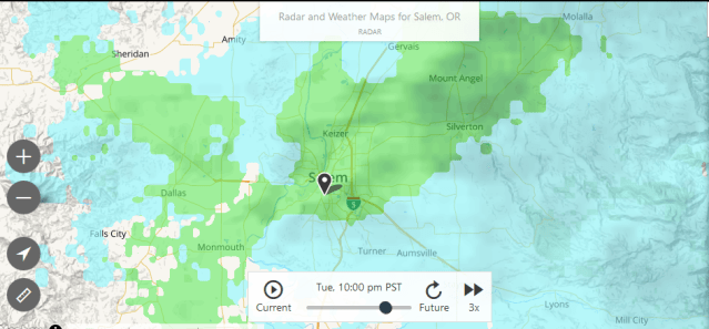
 Snow fell just about everywhere north of Woodburn, so we were actually not very far from snow at all. Snow also fell south of us in parts of Eugene, Springfield, and the area around Sweet Home. Check out this depressing radar image from last night. Take note of the rainy (green) blob centered over Salem and notice the snow (blue) to our north and to our south 😦 grrrrr how frustrating!!! I guess there’s always next time.
- Another point worth mentioning was how cold the temperatures were up in the atmosphere above us Tuesday morning. They were colder than what we had Sunday morning which gave me hope that snow would be on the way.
- We did have snow showers much of the morning, and some of you did have a dusting of snow right around 6 to 8am. So those two aspects worked out well.
- Roads froze up and the cold air did move in as expected. It just came in after the moisture left our region – how typical….
- For my viewers who live north of Woodburn the forecast stayed on track. Below are a few traffic cam pics from this morning showing the winter wonderland that came oh so close to Salem, but yet stayed so far away:
Some things to remember
- No matter how cold it is up in the atmosphere, it is tough to have sticking snow when precipitation is light and when winds are out of the south. It can be done, but those two factors make it much more difficult to achieve.
- I made my own website so I could have my own forecast for all of you, and that’s what I should have done. After all, they don’t pay me the big bucks just to copy and paste other forecasts right?? I have lots of fun, joy, and pride in making my own forecast every single time I update this website, and I go to great lengths to make sure it’s accurate. With so much on the line yesterday I went with a blend of my own personal take on what was going to happen combined with what the “professionals” were calling for. It’s time for me to call my own shots 😉
- Even if I had called my own shots, I still would have been wrong. We did not see any snow last night here in Salem which went against my original forecast.
- I learned some other things about how to better read weather soundings and a few other technical/nerdy weather charts that will help improve my forecasts in the future.
- I guess it’s on to the next storm!!!!
Quick 9:15 update
Snow is still on track to hit Salem soon. Amounts will vary based on location and elevation. In general it won’t be a whole lot; however, everyone should get at least some. Enjoy the evening!!!
The next 5 days.
With everything going on I have not kept this graphic up much. For now here’s what I’m thinking for Wednesday through Sunday. Highlights and additional thoughts below.

Highlights
TODAY/TONIGHT: We are still on track to see some accumulating snow in Salem tonight. As soon as I have a good idea of when it will switch over I will be sure to update the site. For now just plan on sometime after sunset. Keep in mind (assuming this forecast stays on track) that when we finally switch over to accumulating snow, the roads won’t take long at all to get messy. This switch to sticking snow should cover all of the Salem area.
WEDNESDAY: Dry, partly cloudy, but very chilly.
WEDNESDAY OVERNIGHT THROUGH THURSDAY MORNING: In my opinion, this storm gives us our best chance for snow out of all the chances we have had or will have this week. After tonight’s fun I’ll take a closer look at that storm in more detail.
FRIDAY: Very cold start to the day, but dry.
SATURDAY & SUNDAY: Rainy and breezy with very low snow levels. Still several days off, so I’ll also worry about details later.
THE MAIN MESSAGE IS: it will be staying unseasonably cold and wet with lots of mountain snow over the next week.
Tuesday 9am update
Highlights
Snow showers are falling across the area and will continue through the day.
Snow could likely change over to rain for a little while this afternoon and early evening before changing back to snow later tonight.
Roads will stay CLEAR of snow and ice all day today here in Salem, so no need to cancel your plans today.
Still expect snow to stick tonight, but timing and amounts are looking a little different at this point.
These snow events are always tricky and I’m struggling with tonight’s forecast a little. It still looks like we will switch over to sticking/accumulating snow this evening, but that might not happen until we are all in bed (9pm to 11pm). This is good if you have evening plans, but bad if you want a snow day tomorrow. The later time equals lower snowfall totals. We are only a few degrees away from a decent snowfall, so stay tuned as it could still change!!
- The entire Portland metro area is going to be a snowy mess most of the day, so avoid any travel up there if you can.
Snowy Tuesday
Highlights
There’s a small chance for a dusting of snow by sunrise.
Flurries and light snow showers Tuesday morning through the day.
Roads should stay wet during the daylight hours.
Snow will start sticking around 6pm – 8pm at which point roads will quickly ice up.
A slippery/icy commute seems very likely Wednesday morning,
Decent chance for a day off from school Wednesday.
Be prepared for the snow to arrive sooner than expected Tuesday.
The higher hills outside of town could easily see snow all day long.
Corvallis and Albany will see snow showers on and off through the day with some very light accumulations possible, but at this point I’m expecting less for all of you Beavers.
Some Extra Info
Snow totals are near impossible to forecast, but my best guess is that by the time the storm ends early Wednesday morning, I think everyone between Portland down through Salem will have at the very least close to an inch of snow. Many of you will have 2 or 3 inches, and there’s a somewhat decent chance for even a bit more.
Another snowstorm looks LIKELY Wednesday night into Thursday morning, and at this point I would bet on another snow day for schools come Thursday.
