Big time changes

I just performed some big time surgery to the forecast.  In the past 24 hours or so the nice cool down and chance for a good soaking rain next week has quickly been replaced with more hot & dry weather.  Yes, that means the heat will return sooner than previously expected.  Details below:

ALSO, I made some major changes to the website in an attempt to make it more user friendly and useful for my super awesome followers.  First, there’s an archive column on a couple of the pages which should make it easier to go back and reference old posts, you know, in case you need something  to read  for falling asleep quicker 😉  Then we have the new homepage.  This homepage is actually somewhat useful now with info such as snapshots of the current and extended forecasts.  I hope you all like the changes as much as I do and hopefully they make this site more valuable. Okay, now back to the weather…

New beg 1

New beg 2

Basically hot and dry for another 10 or more days with no rainfall in sight.  Enjoy these next couple of “cooler” days, cause by Monday we will be back in the 90s.


Nerdy weather stuff below only for the bravest of men, and women 😉

Now I understand this is a huge change from my previous forecast and I know I have much more to learn in the forecasting world, but with that said, take a look for yourselves at just how crazy it has been trying to give an accurate forecast for next week:  Below is a map from Monday of the estimated total precipitation for western Oregon valued through early next Wednesday morning.

12euro precip This is suppose to be one of the most accurate weather models in the world and here it’s showing around an inch of rain falling for the mid Willamette Valley along with a good soaking rain all across the region.

But, now look at what the same computer model is showing as of tonight:

uh oh

Basically no rain at all for any of us, and instead it has another hot air mass moving right over Oregon.  Thus the sudden change.  It looks like I still have more to learn if I’m going to be better than the pros… 🙂 

Have a wonderful day and be safe out there!!

About my Amazing website

The incredibly popular “Bryan Weather Alerts” are now featured on this stunning website.  Below is a guide to all the pages found on this website and the content/purpose of each page.

Home Page

Contains my latest posts, a link to the Instagram Page, and some forecast updates & highlights you need to know.

The Salem Area Forecast

Contains a nice overview of the day and week’s weather conditions, and sometimes a peak further into the future.

The Mountains and Beyond

Here is where you will find all the weather info you need to know for your Cascade adventures and travels.

WEATHER ALERTS

This page contains the very latest updates to the forecast, especially during big storms and or rapidly changing weather conditions.  In other words, this page is the true “Bryan Weather Alert” page. 😉 

Extra!!

Blog posts which take you beyond the forecast are found here.  These posts usually consist of extra details after a big weather event, graphs, charts, pictures, storm recaps, and other special reports.  Basically lots of “fun” info to be found here!  Posts are organized by our winter/wet season which begin on October 1st each year.  We are currently in the 2020/2021 wet season.

Archives

Monthly reports are found under this tab and are divided up by calendar year making it easy to review old reports whenever you feel like taking a trip down memory lane.

Monthly reports

From time to time I do an “end of month” report for Salem with a few highlights from the previous month along with statistics on how far above or below average we were, how much rain and snow we got, and occasionally some additional fun facts related to the month.

Contact

Contact the one and only Bryan Bowles by dropping a comment on any of my recent postings.  Also be sure to sign up for emails anytime I post a new forecast.  Just find the little “Follow” button in the bottom right corner and add your email.

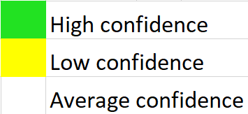
My Forecast Confidence Scale

On the extended forecast graphics you will notice either green, yellow, or no highlighting at all over each day.  This highlighting is one way of communicating confidence for that particular forecast.  This little chart explains what the colors mean, and is a nice visual tool for letting my wonderful viewers know when a forecast is more likely to change a lot or stay the about the same.

confidence scale

A fresh update

Some changes are finally on the horizon in regards to the weather.  Biggest change is the decent chance we have at seeing widespread rain next week.  Details below.

August 1

Thursday & Friday:  Morning clouds will be slow to burn off.  Afternoon sun.

Weekend:  Mild & dry.  Increasing clouds late in the day Sunday, but should still stay nice & dry.


Next week:

August 2

Monday – Wednesday:  Rain showers will dominate this time frame.  Looks like Tuesday could be the wettest day.

Thursday:  Warming up & drying out.

Next weekend:  Currently looks very nice.


Update on the heat

Our hot weather peaks this Sunday and Monday with highs close to 100 both days and lows only dipping down to the mid to upper 60s.  Humidity and smoke will also be on the increase through Monday.

Tuesday will still be quite warm: high 87.

We gradually cool through the week with highs by next Saturday and Sunday only getting into the mid 70s.

Still no rain in sight or any chance for mountain thunderstorms through at least the next 6 days.

Another week of 90s

The title just about says it all.  Sunday will kick off a 7 plus day stretch of high temps in the 90s.  This means the warm nights will return with lows staying in the 60 -67 degree range, so good luck staying cool this week … :/

Cascade Range and Central Oregon

Sunny & hot with no chance for thunderstorms in sight which is very good news for the wildfire threat.  This is also good news if you have recreational plans as it will stay high and dry for you.