A quick Tuesday morning update

Good morning!!  Brand new updated forecast here to help you make it through the week.  What would you do without me??  😉
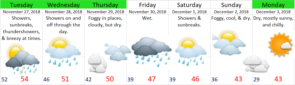
Nov 27.18

Highlights

Looking for a dry day?  Thursday, Saturday, and Sunday are your days this week for completely dry weather.


Day by day:

Tuesday:  A showery type of day.  Some showers will be quite heavy.

Wednesday:  Showers through the day.

Thursday:  Dry, but most of us will be stuck in fog or under low clouds the majority of the day.

Friday:  More showers.

Saturday:  Foggy starts for many of us again, but dry.

Sunday:  Some patchy fog; otherwise sunny & dry.  Cool.

Monday:  Sunny, dry, but quite chilly.


November 20th update

Here’s the latest forecast for Thanksgiving and the rest of the week.

Nov 5


Take away messages are: Thursday afternoon through Friday evening will be very wet, and if you are looking for a dry day than your best bet is Saturday and then again on Monday.

Details

Wednesday:  Light rain through much of the day, specifically the second half of the day.

Thursday:  Showers early turning to steady rain with increasing winds gusting 25 to 30mph.

Friday:  More rain and breezy conditions.

Saturday:  Mostly dry with just a stray left over shower possible.

Sunday:  Mostly cloudy with some light showers.

Monday:  Mostly cloudy, but dry.

Tuesday & Wednesday:  Looking quite wet at this time.

Also keep in mind the Cascades above 3000′ for the most part will be snowy from Thursday afternoon through Saturday morning.  Travel up there the rest of the week should be much better with just wet pavement.

The return of the mountain snow!

Mountain snow will be returning in full force Thanksgiving weekend.  This image shows the estimated total snowfall measured in inches by Saturday afternoon.   Looking at this we can see widespread 15 – 20 inches of snow for the Cascades.  It also shows a bit of snow for the Siskiyous down to our south.  This is great news for ski resorts, for our snowpack, and watershed.

EURO 11.17 mnt snow

To break it down in more practical terms: the best travel times will be any time before Thursday afternoon and then again any time after Saturday morning.  The time frame in between will be a snowy period with the snow levels generally 3000’ – 4000’.


In the gorge

Windy conditions will persist now through Wednesday.  The west end of the gorge will be the focus of these winds with gusts up to 60+mph near Troutdale and out towards Multnomah Falls.


Along the coast

Our storm Thursday evening and Friday will bring wind guests into the 50 – 65mph range, so very windy weather over there.

Thanksgiving Forecast

Thanksgiving is closing in on us and I have put together (just for you) a detailed look at the type of weather conditions we can expect between now through the end of the Thanksgiving weekend.

Remember the images are clickable, so if you want (or need) a closer view then feel free to click on them.  Pretty fancy right???  😉

Nov wetter weather


Sunday – Tuesday:  Dry & sunny with cold nighttime lows.  I expect frosty mornings all 3 days, so bundle up!!

Wednesday:  Increasing clouds through the day.  At this point I think it will be dry, but watching for the chance of some late day showers.

Thursday:  A shower or two early on.  Rain & wind moving in late in the day.  Winds gusting 30 – 40mph.

Friday:  Windy at times with lots of showers.  Gusts up to 40mph in the morning, dying down through the day.

Saturday:  A partly cloudy day with just a few scattered left over showers.

Sunday:  Chance for some light rain.

November 12th update

No fancy graphic this time.  The weather will remain very predictable for at least the next 7 days or longer.  Here are the details:

Today & Tuesday:  Mostly sunny, cool, and dry.  Highs: mid 50s, lows: 32 – 37°

Wednesday:  Lots more clouds with a very slight chance for a rain shower.  Highs: mid 50s.

Thursday – Monday:  dry with mostly sunny afternoons, cold mornings, and patchy fog.  Highs: 51 – 58° & lows: 28 – 36°