Low snowpack

OR snowpack 12.11

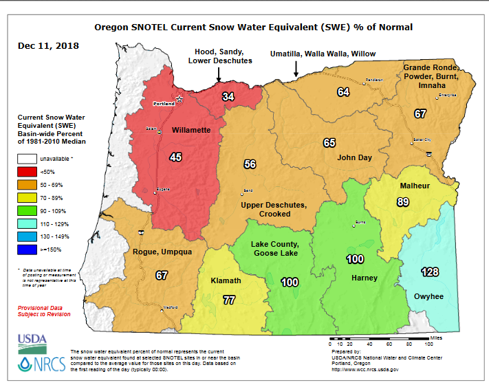
This map depicts the percentage of water stored within the snowpack relative to normal.  You can see most of the state is well below normal.  A combination of mediocre storms and lots of dry days (think back to just last week) and we end up with this low, below average snowpack.

Notice how the southern regions are reporting close to and even above normal conditions.  Above average precip in southern Oregon is common during El Nino winters (like the winter we are in now), and I expect that trend to continue.

To give you an idea of how low the snowpack is, the current base at Hoodoo ski area is 18.5″ of snow.  Not very good.


Forecast

In the meantime I see 5 to 12 inches of snow coming for the mountains tonight and tomorrow.  More the higher up you go in elevation, but even a few inches as low as 2500′ are possible.

Beyond tomorrow I don’t see very much snowfall in the forecast unfortunately.  Hopefully later in the month we can get a series of colder and wetter storms to really build the snow up a bit more.

Drippy Weather

Dec 3


Additional thoughts

Today’s storm as you might have already noticed has brought a fair amount of wind with it.  These breezy conditions will continue until tomorrow morning.  Rain will also pick up later today/tonight.

Another storm arrives Friday late in the day.

Sunday & Monday will be dominated by on and off periods of rain.

Tuesday looks very wet for now.

Our driest time will be Wednesday afternoon through Friday morning.  I suspect fog and clouds will dominate this dry time, so don’t expect very much in the way of sunshine. 

Maybe a few sunbreaks on Wednesday.

Final thought:  Thursday should stay dry, but showers will be lurking just to our north much of the day.  There’s a small chance a shower or two rolls down our way.  Just something to keep in mind if you require dry weather Thursday.


Cold rain ahead

You may be hearing rumors of possible freezing rain or ice, and I’m sure you were just hoping to find out what my thoughts were on the situation.  Luckily, I’ve got a brand new forecast just for you to help settle all those rumors.

Dec 2


Details

It’s cold out there right now and it’s been cold all week long.  No doubt about that.  Now we have clouds moving in.  The question is: will it get icy this weekend?  For the Salem area and most of the valley the answer is no.  Not in any way that should affect your travel plans.  It should be just “warm” enough here to keep us from getting any sort of freezing rain.  Instead we will be left with some very cold rain showers.  Lucky us!!! 😉

If you plan to travel through the Gorge it will be another story.  I expect some spots of ice and even a little bit of snow in the Gorge east of Multnomah Falls and more so out towards The Dalles.


The Cascades

Up in the mountains it looks like some light snow is on tap Saturday with steadier snow Sunday night & Monday.  Tuesday should be dry until evening when more snow will move in.

Snow totals by Thursday of next week should be around 10 – 16 inches for most of the ski resorts and mountain passes.


December 5th

Dec 1

This cold weather is going to last a few more days with lows in the 20s and highs in the 40s.

Moisture returns Saturday for some very chilly rain.  Freezing rain should not be a problem unless your travels take you into the gorge.  Will let you know if that ends up being different… 

More cold rain Sunday with the chance for ice in the Columbia River Gorge.

Monday:  Wet with valley rain and showers and mountain snow.

Tuesday:  Low confidence.  Leaning towards mostly dry with just a couple of showers possible.


Up in the Cascades

Spots of ice and a few inches of snow can be expected in the mountain passes Saturday afternoon through Monday evening.  It won’t be a lot, but enough to make travel a little bit trickier at times.

November Stats

November 2018 has come and gone and I thought I would share some fun (at least in my mind) weather stats for the month.  Feel free to show this knowledge off  to your friends, co-workers, and family members.  They will be impressed I’m sure!  😉  These stats are for Salem, OR and come from the Salem Airport.  They are available online if you wish to learn more.


November 2018

Warmest high temp was 67°   November 2nd

Coldest high temp was 43°   November 25th


Warmest low temp was 57°   November 1st

Coldest low temp was 25°   November 20th


For temperature we had:

17 days above normal

1 day right at normal

12 days below normal

7 days with lows at or below freezing.


Precipitation:

Precipitation fell 12 days.

18 days were completely dry.

The wettest day was November 27th with 1.06” of rain.

We ended the month with only 3.86” of rain.  That equates to 2.64” below normal.

No snow (of course).


November 2018 will go down in the record books as much drier than normal month with roughly 59% of our typical November rainfall, and slightly warmer than normal by about 1.87°.

That’s all the stats I have.  Now get out there and show everyone just how smart you are!!


For the deepest of learners:

The process for determining whether or not a day is above or below normal temperature wise is complicated, but works like this.  First add the high & low temps together, then divide the answer by 2.  For example, on December 2nd the high was 49° & the low was 38°.  Those two numbers added up equal 87°.  Divide 87° by 2 and we get 43.5°.  Round to nearest whole number, which in this case is 44°.   Do the same process with the normal high and low temps for the day.  The normal temps on December 2nd are 48° and 36° respectively.  Adding those together gives us 84°.  Divide 84° by 2 and we end up with 42°

The difference between these two numbers (44° & 42°) determines the answer.

44° – 42° =This means December 2nd, 2018 will officially go down as 2 degrees above normal.  

Hope that made at least a little bit of sense to you all.

Quick mountain update

A period of moderate to heavy snow looks likely Friday afternoon through Friday night.  Snow showers will continue Saturday (heavy at times).  The snow level should start up around 3500′ Friday afternoon before coming down to 2000′. 

Come Sunday morning most ski resorts will have accumulated a solid 6 to 12 inches of new snow.

Sunday through Thursday will be similar to the valley: dry, sunny, good travel weather, but cold!!

Nov 29th update

Cool Dec

Highlights

We have two wet days ahead of us before entering into a very cool and dry winter weather pattern.  Next week will be a chilly one with lots of very cool and frosty mornings.


Details

Friday:  Stormy with showers & rain.  Breezy at times.

Saturday:  Showers, some could be quite heavy

Sunday:  A couple lingering showers early on, then dry.

Monday – Thursday:  Clear & sunny, but cold.  Daytime highs in the low to mid 40s and lows in the low to mid 20s.


One last thing

There’s a small chance the showers on Sunday will stick around longer than I’m indicating on this forecast.  Perhaps into the evening.  This is the only real change or possible “surprise” I see in our forecast.  The rest of the days look good to go 🙂